The Journal Of Antiquities

Ancient Sites In Great Britain & Southern Ireland


Duddo Five Stones, Northumbria

Duddo Stone Circle This beautiful stone circle...

Duddo Stone Circle  (Photo credit: Andrew Curtis – Wikipedia)

OS grid reference NT 9305 4370. Three-quarters of a mile to the north of the village of Duddo in Northumbria stands the Bronze-Age monument known as Duddo Five Stones, which are actually the remains of a small stone circle. The five stone monoliths stand clustered together at the western side of Mattilees Hill beside a footpath in a field half-way between Grindonrigg and Felkington. Coldstream on the A698 is 6 miles to the south-west, while the nearest main road to the stone circle is the B6354. Scotland is 4 miles to the north.

The five stones stand upon a low, grassy hill (tumulus) and cover an area of 10 metres or nearly 33 feet. It’s likely the circle of stones marks the site of a prehistoric burial, dating from the Bronze-Age upto 4,000 years ago; the stones being erected over this as a sign that it was, and still is, a sacred place where a chieftain or some other notable person(s) lie buried, perhaps several members of an ancient tribe? The tallest of the stones is 2.3 metres high or 7 foot 6 inches; the other stones are less high and vary in size from 1.5 metres to 2.1 metres (5 foot to 6 feet 10 inches) high. Originally there were seven standing stones, but the other two were lost in c1850. During excavations in the 1890s and early 1900s two holes were uncovered indicating where the other two monoliths had stood and some bones and charcoal were found. One of the stones had  later toppled over which had led to Ordnance Survey recording on their maps that the site was called Duddo Four Stones. Luckily this stone was re-erected in 1903; and one or two of the other stones may not be (in situ) in their original places. Aubrey Burl, the well-respected English archaeologist, has visited the site on a number of occassions since the 1970s.

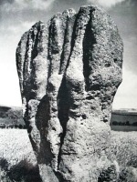
Duddo Stone, Northumbria.

Duddo Stone (picture credit Garry Hogg)

Over the centuries The Duddo Stones have aquired many strange names owing perhaps to the deep grooves that can be seen in all the stones – caused by 4,000 years of erosion due to rain and wind that often sweeps relentlessly across the hills and moors and, because the stones are made of sandstone rain running down the sides has made strange grooves or gulleys. The largest stone has been likened to “a clenched fist rising menacingly out of the rough turf,” according to Garry Hogg in his book Odd Aspects of England. One legend says that seven people working here on the Sabbath day were turned to stone as a warning to other locals. Other names include: ‘The Singing Stones’, ‘The Women’ and ‘The Seven Turnip Pickers’! The largest stone has possible cup-marks and there are said to be cup-markings on one or two of the other stones. Duddo Five Stones is said to be aligned with the Winter solstice. The circle is in the ownership of English Heritage.

Sources:-

Hogg, Garry., Odd Aspects of England, David & Charles, Newton Abbot, Devon, 1968.

Bord, Janet & Colin., Ancient Mysteries of Britain, p 208, Diamond Books (Harper Collins Publishers Ltd), 1991.

https://en.wikipedia.org/wiki/Duddo_Five_Stones

http://heritageaction.wordpress.com/2012/10/07/setting-of-duddo-stone-circle-saved-again-for-a-while/


Rebecca’s Well, Wargrave, Berkshire

OS grid reference SU 7993 8048. One mile north of Wargrave village in woodland on the side of Crazies Hill and a few hundred metres north-east of Gibstroude farm, stands a Victorian wellhouse covering a more ancient spring now called Rebecca’s Well, but before that time it had always been called Rebra’s Well. The curious name ‘Crazies Hill’ is locally said to mean Cray-wy-seath Hill or ‘the hill of the fresh clean water of the waterless place’, which obviously refers to the old well there. Rebra’s Well is apparently ‘the healthy water place on the hill’, being pronounced in the local dialect form ‘Reb bar yagh wylle’, and “perhaps” being named for Rebecca (Rebekah) the prophetess from the Old Testament. The well is located in the woods just a little to the south of Crazies Hill Lane on the way to Cockpole Green. The town of Reading is 8 miles to the south-west.

The ancient well of Rebra had become, over the years, a muddy pool in the woodland at Crazies Hill, but it had been a source of water for the folk of Crazies Hill for some considerable time, indeed they had apparently frequented it for its health-giving, healing properties. In 1870 the local parson Reverend Greville Phillimore ordained that his flock “should not be revering the water alone,” so he decided to build a proper wellhouse and honour a Biblical personage in the form of Rebecca, believing the original name Rebra to be a shortened form of her name? The good reverend designed the interior well-basin himself, but he commissioned Gertrude Jekyll (1843-1932) the celebrated English garden designer to design the wellhouse, and what a delightful job she did too.

The folly-like building made of plastered-over brickwork is 10 foot high and has a conical tiled roof with gabled frontage; the design plan is a semi-circular one. There is a circular arch at the front with an inscription ‘REBECCA AND THE SERVANTS OF ABRAHAM AT THE WELL OF NAHOR’. The colourful painting on the front depicts Rebecca and a servant, or Isaac her husband, standing beside the well of Nahor. Inside the wellhouse there is a large round-shaped stone basin where the water now collects, sometimes though not always in a good quantity, and at the rear of this a carved stone with another inscription and a cross all in segmented panels. The well usually has an iron gate in front of the water basin that can be opened for access.

According to the O.T. (The Book of Genesis) the servants of the Prophet Abraham ran to meet Rebekah and said “let I pray thee drink a little water of thy pitcher” at the well of Nahor. The actual Biblical well was at a place called Haran or Horan just outside the city gates of Nahor in Mesopotamia, which is today the land between the rivers Tigris and Euphrates, including parts of Iraq, Iran, Syria and Turkey. Rebecca was the wife of the Patriarch Isaac and granddaughter of Nahor, brother of Abraham. She was the mother of Jacob and Esau and great-niece of Abraham. Legend says the died at Haran (Horan) and was buried in the Cave of the Patriarchs at Machpelah, near Memre. But Rebecca is remembered for her great hospitality to travellers (guests) traversing the hot Mesopotamian desert with their camels and, for providing water for them at the well of Nahor, which she always did with much humility, kindness and graciousness, thinking only for the well-being of her guests at all times.

Sources:-

http://www.imagesofengland.org.uk/Details/Default.aspx?id=395246&mode=adv

http://www.britishlistedbuildings.co.uk/en-395246-rebecca-s-well-wargrave

http://people.bath.ac.uk/liskmj/living-spring/sourcearchive/ns2/ns2mb1.htm


1 Comment

St Matthew’s Churchyard Cross, Rastrick, West Yorkshire

Rastrick churchyard cross of (Wikipedia).

The Rastrick church-yard cross, drawing by Joseph Horsfall Turner, 1893 (Wikipedia)

    OS grid reference: SE 1383 2160. The cross-base stands near the entrance to St Matthew’s Church in the village of Rastrick, near Brighouse, West Yorkshire. It can be reached via the A643 Crowtrees Lane and Church Street at the south-western edge of the village; the church is an imposing building with a nice rotunda-like roof. The cross-base is located just inside the walled-churchyard enclosure, near the main entrance, and so can’t really be missed.

    This three and a half foot-high (1.06metre) cross-base is said to be Anglo-Saxon and probably dates from the 10th-11th century AD. It is all that now remains of a once proud Saxon high cross the shaft with its decorated cross-head would have stood inside the large, round socketed hole which measures 30cm by 25cm by about 15cm in depth. The rest of the cross has long since disapeared. The base-stone is of dressed gritstone which tapers away about three-quarters of the way up (75cm or 29′); the bottom of the base being square (52cms or 20′).
.
    There is a single line of roll-moulding running around the socket base and all four corners, one being edged with cable moulding. Some faint roll-moulding also runs around the top edge, just 5cm beneath the rim which, may also have faint traces of knotworking. Each of the faces of the base show more faint lines of roll-moulding from panels that have carved decoration. The south face has what is probably ‘The Tree of Life’ which comprises of scroll-like branches (interlacing) coming out in a sideways direction from the central stem. This type of decoration is repeated (but much eroded) on the west face, which was originally considered to be empty of any carvings. On the north face the panel is divided by a straight-rib flanked by interlacing – this too is probably a representation of ‘The Tree of Life’.
.
    It seems that the cross-base stands in it’s original position on or near to a Roman road that traversed the village – the cross would have no doubt marked what was originally an ecclesiastical boundary, or perhaps it was a graveyard marker for a Saxon cemetary. The cross-base is now a scheduled ancient monument listed as No 23376.  It is also grade II listed.
.
References:-
 .
Register of Ancient Monuments Calderdale Council / environment / conservation and ancient monuments.
The Northern Antiquarian – Ancient Crosses.
.


2 Comments

Malham Roman Camp, Low Stoney Bank, North Yorkshire

OS grid reference SD 9152 6542. On a high plateau of Malham Moor just above Low Stoney Bank, a few miles north of Malham and just east of the river Aire, are the large rectangular-shaped earthworks of Malham Roman Camp or Mastiles Roman Camp, dating from c71 AD. The earthworks cover 20 acres (96800 square yards). The camp was a temporary military camp built during the governorship of Quintus Petillius Cerialis (71-74 AD) in order to quell a rebellion by fearsome Brigantean warriors who inhabited that area and, whose leader had been Queen Cartamandua. She had earlier formed a rather ‘fragile’ alliance with the Romans in c52 AD – although this was only destined to last a short time.

The camp is quite well-defined and has an earthern bank 0.5 metres high and 5 metres wide with traces of an external ditch. There are four entrances, three of these at the north, east and south sides have an in-turned or curved inner bank, while the western entrance is damaged by a footpath and wall passing through the centre of the camp, left to right, which is known today by country walkers as Mastiles Lane.

English: Mastiles Lane Roman Marching Camp. Th...

Malham ‘Mastiles’ Roman Camp (Photo: John Illingworth – Geograph)

The camp was probably built by either the IX or XX legions who may have also had a hand in the building of the forts at Rey Cross beside the A66 at Stainmore Summit and, Stanwick, near Richmond. There are no traces of buildings inside the earthworks – it is presumed the soldiers lived in leather tents in the middle of the camp. Some 500 soldiers or more would have marched here at any one given time during the late 1st century AD, but the site was most likely abandoned when the tribal unrest subsided within a few years. We don’t know for sure whether the camp was ever re-occupied?

Sources:-

http://www.brigantesnation.com/SiteResearch/Roman/Malham/Malham.htm

http://www.outofoblivion.org.uk/record.asp?id=352


Trethevy Quoit, Tremar, Cornwall

Trethevy Quoit, Cornwall.

Trethevy Quoit,

OS grid reference SX2593 6881. Some 2 miles to the west of the B3254 road between Liskeard and Launceston and 1 mile east of Tremar Coombe, on the edge of Bodmin Moor, stands the prehistoric burial chamber or portal tomb called Trethevy Quoit. The monument stands in a field along a short footpath at the west-side of Tremar village, not far from Trethevy Cottage. The town of Liskeard is 5 miles to the south and the village of St Cleer is 2 miles to the south-west. Trethevy Quoit or ‘Dolmen’, to give it it’s other monument name, dates back at least 5,700 years. Locally it is called ‘The Giant’s House.

Trethevy Quoit is still quite an impressive prehistoric monument standing at 9-10 foot high with it’s huge sloping capstone that looks as if it is poised to slide down to the ground at any moment! It is the largest and most impressive in Cornwall. The massive capstone is 12 foot long and is said to weigh 10 tonnes. It is supported by five upright stone slabs all roughly nine feet high and one other slab that does not connect with the capstone; originally there were seven uprights. Near the top of the capstone there is a large round hole, but what this was for is uncertain, maybe for astronomical purposes or to catch the sun’s rays at cerain times of the year (soltices), or perhaps it was made in more recent times?

Trethevy Quoit - Liskeard - Cornwall - UK

Trethevy Quoit  (Photo credit: Wikipedia)

There is also some uncertainty about the age of the monument; some historians say that it is from the middle to late Neolithic Age around 3,700-3,500 BC (the middle Stone-Age), while others think that it dates from the Bronze Age (about 1,800-1,200 BC). The back of the burial chamber has now fallen inwards, while at the front there is a large portal stone and a flanking stone that stands clear of the monument. But it seems that the funery entrance was not at the front but at the side where there is a square-shaped opening at the bottom corner to enable bodies to be placed inside. Originally a huge oval-shaped mound of earth would have ‘probably’ covered the stone chamber and was thought to have been over 6 metres in circumference – there is still a slight raised bank around the sides and evidence of the mound is still visible today. This was almost certainly the burial place of a chieftain or some high-ranking individual from a prehistoric tribe that inhabited the area thousands of years ago back in the mists of time.

About 1 mile to the north-west stand ‘The Hurlers’, three early Bronze-Age stone circles.

Sources:-

Darvill, Timothy, Glovebox Guide – Ancient Britain, AA Publishing, Basingstoke, Hampshire, 1988.

Hogg, Garry, Odd Aspects of England, David & Charles, Newton Abbot, 1968.

Bord, Janet & Colin, Ancient Mysteries of Britain, Diamond Books (Harper Collins Publishers Ltd), 1994.