The Journal Of Antiquities

Ancient Sites In Great Britain & Southern Ireland


Dyffryn Ardudwy Burial Chamber, Gwynedd, North Wales

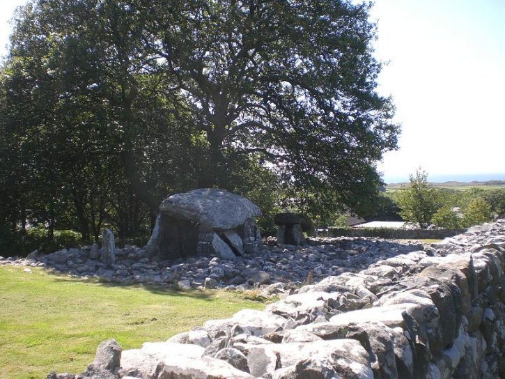
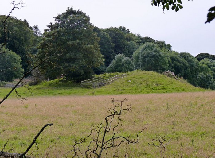
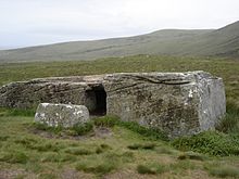
Dyffryn Burial Chamber outskirts. Pjposullivan (Creative Commons)

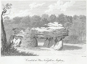
   OS Grid Reference: SH 5887 2284. Neolithic monument consisting of two independent burial chambers stands in a field, 200 feet above sea-level, at the east side of Dyffryn Ardudwy village, Gwynedd, on the western slopes of Moelfre Hill which rises to 1932 feet. Dyffryn Ardudwy is 5 miles north of Barmouth. The ancient monument from about 4000 BC is also known as a ‘chambered cairn’, ‘portal dolmen’ and ‘cromlech’; it goes by several other names including Arthur’s Quoit, Carreg Arthur and Coaten Arthur. These megalithic burial chambers or dolmens can be reached by way of a lane running east off the A496 (coast road to Harlech) just before, or after Bro Arthur, depending on which way you are walking, and then by a short footpath into the fields (passing close by the village school) for maybe 100 metres east of the village. It is marked by a large cairn of stones spread widely about and two burial chambers that are set-apart, each of them having upright slab-stones and huge sloping capstones.

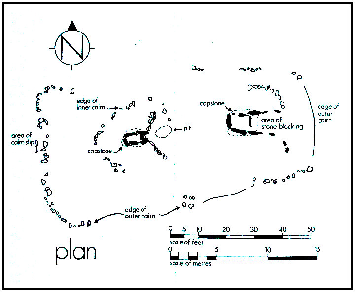
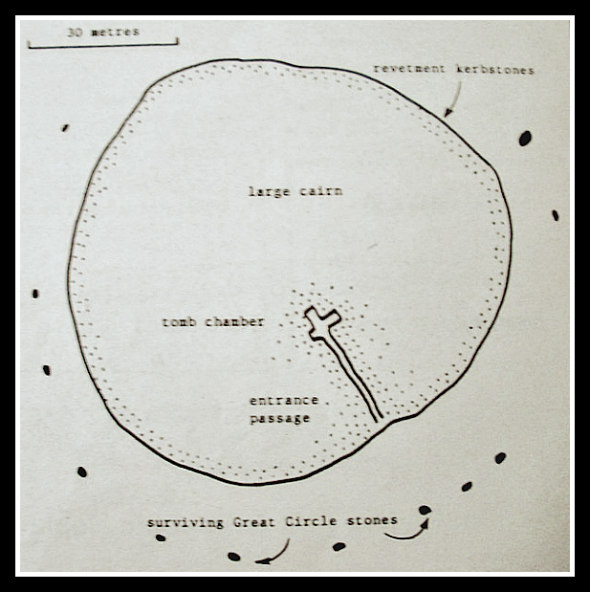
Dyffryn Ardudwy Burial Chamber, Gwynedd in North Wales. Plan.

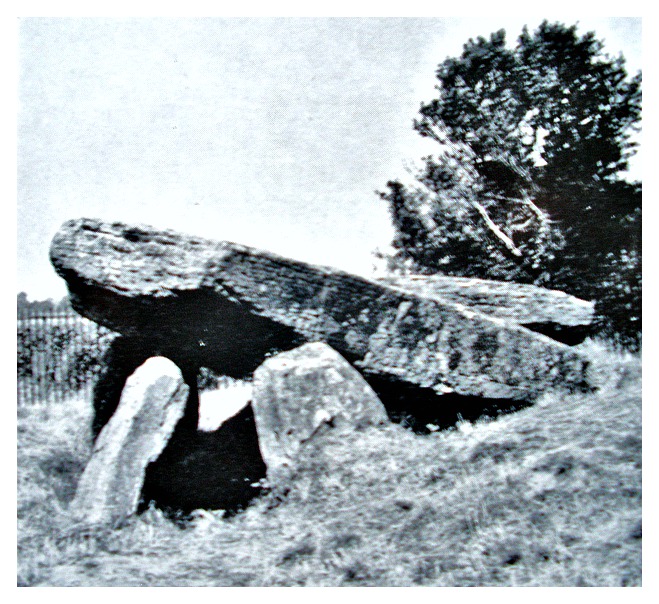
   Some very good information is given in the following description by T. G. E. Powell, MA, FSA (Reader in Prehistoric Archaeology, University of Liverpool), and here quoted in full. He says: “It will be understood that the cairn  had been used over a long period as a quarry for stones to build the neighbouring walls and perhaps older structures no longer visible. Only the basal layers of cairn stones therefore survived, but sufficient to show that it had been roughly trapezoidal in plan, measuring  about 100ft in length, and in width some 35ft at the eastern end and 54ft at the western end. The cairn had a rough edge of small boulders. It’s bulk was made up of loose stones of kinds that could have been collected nearby. The megalithic slabs of which the chambers were built come from grits and slates of the Cambrian series and could have been obtained on the hillside. Excavation disclosed that there had been two periods of construction at the site. First, the smaller, western, chamber had been put up and surrounded by a small oval cairn. Later, but at perhaps no great lapse of time, the larger, eastern, chamber had been erected; then the trapezoidal cairn had been built to envelope everything. Whether this final cairn covered the capstones of both burial chambers cannot be proven, but it is likely that the cairn reached at least as high as their edges.

   “The construction of the western chamber shows it to be of a type often called for convenience a ‘Portal Dolmen’. At the higher, eastern end there is a pair of massive forward projecting stones with a high blocking stone between. These form a portal although one that is blind or non-functional. Access to the chamber was doubtless over the low slab forming the southern side. The floor of the chamber consists of a single large flat rock probably found here in its natural position by the original builders. The markedly sloped position of the capstone resting on the two portal stones and on the end stone of the chamber should be noted as characteristic of the Portal Dolmen type.

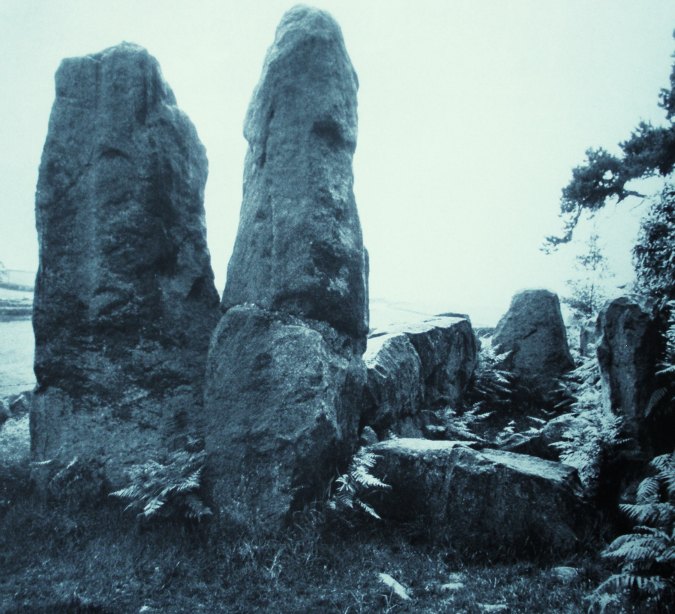
   “The eastern chamber was much more ambitious in construction, especially in the width to be spanned and in the weight of the capstone that was raised into position. It was found necessary in 1961-62 to provide additional support for this great roofing stone and a buttress was built on either side of the chamber for this purpose. This chamber stands some 28ft east of the other and is itself some 12ft long, splaying in width from 5 to 7ft. A low cross-slab with broken upper edge should be noted near the eastern end within the chamber. This may have stood to a greater height, thus acting as a partial closing stone. The gap between its free end and the southern side of the chamber was found to have been filled with blocks. A gap towards the rear in the walling of the north side of the chamber may have been intentional as it was spanned only by small flat slabs and no socket for a missing upright came to light. Eastwards of the cross-slab, the projecting walls of the chamber provided a kind of covered portico; then there was an open area bounded by small uprights of various heights, more or less continuing the shape of the portico. Finally, all this area the cross-slab outwards was sealed up with a massive blocking of sloped slabs and cairnstones. 

   “The original contents of the western chamber (Portal Dolmen) are unknown and had doubtless long been destroyed, but a pit under the cairn, just in front of the portal, produced a quantity of potsherds of a recognizable Neolithic ware. The original deposits in the eastern chamber had not been so much thrown out as thoroughly disturbed and mixed up with modern rubbish. Potsherds of several kinds were however found, as well as two polished stone pendants and some traces of cremation burials.”

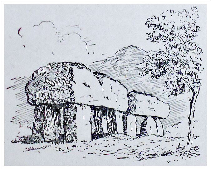
Dept of Environ-ment & H.M.S.O leaflet

   T. G. E. Powell in his conclusion of the site at Dyffryn Ardudwy says that: “This chambered cairn is a com-posite burial monument first having consisted of a small megalithic chamber of Portal Dolmen type surrounded by a small oval cairn. The  Portal Dolmen type is widely distributed in the coastlands of Wales, in Cornwall, and in Ireland. The Neolithic pottery found in the pit associated with this chamber at Dyffryn Ardudwy is related  to similar  wares known from Pembrokeshire and Cornwall. It was not possible to obtain any material during the excavation suitable for radio-carbon measurement so that only a suggestion based on other evidence can be given about date. On present information it seems likely that this Portal Dolmen was erected the middle of the third mill. BC. Subsequently, a larger megalithic tomb was built and the cairn proper to this chamber was extended so as to envelope the older monument to the west. The somewhat irregular shape of this cairn may be explained by this factor in conjunction with the slope of the ground. Pottery recovered from the eastern chamber belonged to various types and suggested a period of use beginning a little later than that of the Portal Dolmen, continuing perhaps to the opening of the second mill. BC. The general structural characteristics of the eastern  chamber, and its trapezoidal cairn, suggest a mixing of building practices owing something to the Portal Dolmen tradition, but more to influences coming by pastoral routes through the mountains from the Cotswolds and south-eastern Wales.”

   Chris Barber & John Godfrey Williams (1989) say of this site that: “On early Ordnance Survey maps they are marked as Cromlech and as Burial Chamber on later ones.” Bill Anderton (1991) says that: “As part of an outbreak of light phenomena, columns of light were seen issuing from the ground here in 1905. The site stands on the Morchras geological fault.” Christopher Houlder (1978) describes it as a “long cairn” and also adds that: “The cairn lies in an area of some of the finest Iron Age cultivation terraces in the country, visible on the hillside above.” And Jacquetta Hawkes (1975) informs us that: “The Dyffryn long barrow is approached through the iron gates of the village school and will be found alongside the playground not many yards from the highway. Hawkes goes on to say: “The barrow was excavated in the 1960’s revealing a long and complex history.”

Sources and related websites:-

Anderton, Bill, Guide To Ancient Britain, Foulsham, Slough, Berkshire, 1991. 

Barber, Chris & Williams, John Godfrey, The Ancient Stones of Wales, Blorenge Books, Abergavenny, Gwent, 1989.

Hawkes, Jacquetta, A Guide To The Prehistoric And Roman Monuments In England And Wales, Cardinal (Sphere Books Ltd.,) London, 1975. 

Houlder, Christopher, Wales: An Archaeological Guide, Faber & Faber, London, 1978.

Powell, T. G. E., Dyffryn Cairn – the megalithic chambered cairn at Dyffryn Ardudwy, Merionethshire, Dept of the Environment Ancient Monuments and Historic Buildings on behalf of the Welsh Office – for H. M. S. O, 1973.

https://en.wikipedia.org/wiki/Dyffryn_Ardudwy      The photo (above) from the Wikipedia website is displayed under the Creative Commons Attribution Share-Alike License.

http://cadw.gov.wales/daysout/dyffrynardudwyburialchamber/?lang=en

http://www.megalithics.com/wales/dyffryn/dyffmain.htm

http://www.megalithic.co.uk/article.php?sid=4449

                                                                                     © Ray Spencer, The Journal Of Antiquities, 2017.


1 Comment

Cashtal-yn-Ard, Near Glen Mona, Isle Of Man

Cashtal-yn-Ard, Isle of Man (photo by Chris Gunns (Wikipedia)

Cashtal-yn-Ard (photo by Chris Gunns – Wikipedia)

   OS Grid Reference: SC 46222 89226. The ancient burial chamber known as ‘Cashtal-yn-Ard’ stands on the edge of a hill to the northeast of Glen Mona, just to the south of Cornaa in the parish of Maughold, and close to the eastern coastline of Isle of Man. It is said to date back some 4,000 years to the New Stone Age (the Neolithic). It is quite a large megalithic structure at 130 feet in length. The name ‘Cashtal-yn-Ard is thought to mean ‘The Castle of the Heights’. However, today this megalithic burial cairn is minus its conical mound of earth and stones, but it still looks very impressive. From the A2 Laxey to Ramsey road at Glen Mona village: take the country lane towards Cornaa for 1 mile. Halfway along, and just after and opposite the entrance to Rhenab Farm on the left-hand side, walk northwest up the footpath for 180m to the southern edge of the hill – there in front of you stands the chambered burial cairn of Cashtal-yn-Ard.

   Cashtal-yn-Ard is a large, oblong shaped chambered cairn dating from the late Neolithic Age – roughly between 1,800-2,000 BC. It covers a large area some 40m (131 ft) long and 14m (46 ft) wide, and still has its outer kerb stones, forecourt, entrance and 5 burial chambers (compartments). The side stones (or slabs) of these burial chambers are angled inwards and some have jagged edges, though sadly all but one of the roof-slabs have been lost, although this long flat-slab might not be the original one. Some of the large standing stones at the entrance have been re-erected or replaced. However, its large conical mound of earth and stones, probably more stones than earth, has gone – the stones now lost to local walls and maybe farm buildings? The monument is very well-preserved and is said to be the largest of its kind in Britain.

   Here at Cashtal-yn-Ard it is thought chieftains of the New Stone Age (the Neolithic) were buried maybe with members of their close families. Indeed during excavations back in 1932-35 funerey urns and other artefacts were found. It was also excavated more recently in 1999. At the E. side there is a small grassy mound consisting of earth and stones.  The orientation of this monu-ment is said to be almost W-E. There are two more Neolithic tombs on the island – similar in size to this one.

   In the publication ‘The Ancient And Historic Monuments of the Isle of Man’, there is more information on this site. It says that this is an: “Outstanding example of a megalithic chambered cairn, of ‘Clyde-Carlingford’ type, burial place of chieftains of the New Stone Age, about 2000 B.C. A semi-circular forecourt at the western end gives access, through a ‘portal’ of two standing stones, to a burial chamber of five compartments, originally slab-roofed. Here unburnt bones, pottery and flints were found. East of the the burial chambers is a mound of earth and stones reddened and fused by heat. The whole monument, apart from the forecourt, was originally covered by a massive oblong cairn 130 feet long.”

Sources and related websites:-

Hulme, Peter J., More Rambling In The Isle Of Man, The Manx Experience, Douglas, Isle of Man, 1993.

The Ancient And Historic Monuments – of the Isle of Man, (Fourth (Revised) Edition, The Manx Museum And National Trust, Douglas, 1973.

The Viking Heritage – Isle Of Man – Millennium Of Tynwald, Shearwater Press, Douglas, Isle of Man, 1979.

https://de.wikipedia.org/wiki/Cashtal_yn_Ard

http://www.megalithic.co.uk/article.php?sid=5944

http://www.iomguide.com/cashtalynard.php

http://www.isle-of-man.com/manxnotebook/history/arch/aj16n4.htm

                                                                                       © Ray Spencer, The Journal of Antiquities, 2016.


1 Comment

Plas Newydd Burial Chamber, Llanfair P.G., Anglesey

Cromlech at Plas Newydd, Anglesey (Drawing)

Cromlech at Plas Newydd, in Anglesey (Old Drawing)

    OS grid reference: SH 5198 6972. Plas Newydd prehistoric burial chamber, cromlech or dolmen, stands just 300 metres north-east of the shoreline of the Menai Straits – at the south-side of the island of Angle-sey and, just opposite Plas Newydd House and Country Park – in whose “private” grounds it is situated. The site is 1½ miles south-west of Llanfair P.G. village and Menai Bridge, which links the Welsh main-land to the island. After the Menai Bridge and link-road take the A5 road, then the  A4080 (Ffordd Brynsiencyn) road to the south-west for 1 mile. Take the first lane that runs off this road (south) to the NT Plas Newydd House. The ancient monument is just 150m to the south-east of the carpark and on private land in front of the big house! And ½ a mile to the south, at the edge of the country park, is a second ancient monument, Bryn-yr-Hen Bobl, which is a chambered cairn.

Cromlech at Plas Newydd in Anglesey (engraving 1799 Wikipedia)

Cromlech at Plas Newydd, Anglesey by Caroline Metz, 1799, Wikipedia)

    There are actually two burial chambers next to each other here, the larger one having a gigantic oblong-shaped capstone weighing many tonnes and measuring 3.5m x 3m, which is supported by five large and sturdy uprights, whereas the smaller chamber’s capstone is 2m x 1.7m and is supported by three smaller, round-shaped boulders. It would seem that the smaller monument acted as an antechamber (passage-way) to the larger monument. These burial chambers are said to date from the Neolithic age. Nearby there are some boulders embedded in the ground – they are probably outliers – and maybe an indication that the burial site once covered a larger area than it does now. There is no sign today of the large earthen mound that would have originally covered these monuments, or did each burial chamber have its own separate covering mound?

    Author Christopher Houlder in his work ‘Wales: An Archaeological Guide’, says of the site: “In parkland overlooking the Menai Strait is a megalithic tomb consisting of a main chamber 3 m by 2.4 m and a smaller antechamber, each with its own capstone, but there is no mound or other feature to give cultural definition.”

    And likewise, author Jacquetta Hawkes, in her book ‘A Guide To The Prehistoric And Roman Monuments In England And Wales’, says of the site: “The Plas Newydd dolmen stands at the end of the drive between the mansion and a cricket field where it commands a view across the Straits. In such a place it at once suggests an eighteenth-century folly, an ornament to the house put up by some romantically minded peer. In truth, however, it is a genuine prehistoric monument of a rather unusual kind; thereare two adjacent chambers, one larger than the other, with very massive uprights and capstones, separated by a single upright. It is possible, though not to my mind likely, that the smaller chamber was originally a passage or antechamber giving access to the larger.”

    Plas Newydd burial chamber were first marked as a cromlech on the OS map of 1841 and as Burial Chamber on the 1947 map, and later ones. There was apparently an early reference and illustration in ‘Druidical Antiquities’ published by S. Hooper in April 1784, which shows two capstones with the larger one resting on five uprights, according to Chris Barber in his work ‘The Ancient Stones of Wales’.

Bryn-yr-Hen Bobl burial Chamber (phot credit: robinLeicester - Wikipedia)

Bryn-yr-Hen-Bobl (photo credit: Robin Leicester – Wikipedia)

    About ½ a mile to the south (OS grid ref: SH 5189 6900) and at the edge of the country park, there is another ancient monument. Again it is on private land. This is Bryn-yr-Hen Bobl, a kidney-shaped grassy mound with a couple of trees on it – and a chambered cairn and funnel-shaped forecourt facing E. There is a revetted terrace some 12m wide extending 100m to the S. This megalithic burial tomb was excavated back in 1929 at which time some ‘earlier’ Neolithic artefacts were found including stone axes, plain ‘western’ and Peterborough types of pottery. “The tomb contained the remains of at least twenty individuals”. (Houlder, 1978)

Sources:

Barber, Chris & Williams, John Godfrey., The Ancient Stones of Wales, Blorenge Books, Abergavenny, Gwent, 1989.

Hawkes, Jacquetta., A Guide To The Prehistoric And Roman Monuments In England And Wales, Cardinal, London, 1975.

https://commons.wikimedia.org/wiki/File:Bryn-yr-Hen-Bobl_Burial_Chamber,_Plas_Newydd,_Anglesey.jpg    This photo is displayed under the terms of the Creative Commons Attribution-Share Alike 4.0 International license.

https://en.wikipedia.org/wiki/Plas_Newydd_(Anglesey)

http://www.coflein.gov.uk/en/site/93829/details/PLAS+NEWYDD+BURIAL+CHAMBER/

Houlder, Christopher., Wales: An Archaeological Guide, Faber, London, 1978.


1 Comment

Maen Ceti (Arthur’s Stone), Cefn Bryn, Reynoldston, Gower, Wales

Maen Ceti (Arthur's Stone) illustration.

Maen Ceti (Arthur’s Stone) illustration.

    OS grid reference: SS 4914 9055. On the south-facing ridge of Cefn-y- Bryn, overlooking the village of Reynoldston, on the Gower Peninsula, stands the Neolithic burial chamber known as Maen Ceti, but more commonly known as ‘Arthur’s Stone’. Maen Ceti means just that – ‘The Stone of Ceti’. This well-known ancient, megalithic chambered tomb, with its huge capstone is variously known as a cromlech, a dolmen and a quoit, but they all mean the same thing in reality – a burial chamber. It is located 300 yards to the north of the main road that crosses Cefn Bryn – between Reynoldston and Cillibion  – ¾ a mile to the east of Reynoldston village.  There are many footpaths criss-crossing the 609 foot-high Cefn Bryn Hill, which is locally called ‘the common’, but at least two of these moorland paths head to Maen Ceti from the road; the ancient monument can quite easily be seen once you start to climb up onto the ridge itself. The village of Llanrhidian is a further mile to the north of Maen Ceti.

Plan of Maen Ceti (Arthur's Stone).

*Plan of Maen Ceti (Arthur’s Stone)

    The monument is a double chambered tomb that consists of a huge capstone, a glacial boulder of millstone grit measuring 12 feet across, which is supported on four small up-rights, with a large part of the capstone having fallen to the ground at the side and another bit partly lying beneath the capstone, and there are six other small stones lying around the monument and beneath it, which presumably were up-rights that “now” don’t support the great stone. Maen Cetti burial chamber is 8 feet high and dates from the Neolithic – 2, 500 BC, or maybe earlier. The capstone weighs as much as 25 tons, or it used to do, so it would have been ‘a great fete of strength’ on the part of the builders of the monument.

    “The raising of the huge stone onto its supports has also be summed up in ancient records as one of ‘the three arduous undertakings accomplished in Britain, the old proverb: Mal gwaith Maen Ceti – ‘Like the labour of the Stone of Ceti” supports that fact, according to Chris Barber ‘More Mysterious Wales’. The burial chamber has taken a battering from the elements on the high ridge of Cefn Bryn, being very exposed to high winds and driving rain, ‘causing the capstone to split in two places – though this feature is often put down to other things in legend including King Arthur’s sword Excalibur and, even St David, who took a dislike to the pagan stone. Long ago a large mound of earth and stones covered the burial chamber, but nothing much of that remains – although there are traces of a ring cairn.

    Barber in ‘The Ancient Stones of Wales’, says that: “It is marked as Arthur’s Stone on the first Ordnance Survey map of 1830 and later editions.” He says that in its Welsh name “It is first mentioned in a Triad of the 10th century.” And that: “There are over 70 literary references to Arthur’s Stone and it is better documented than any other prehistoric stone monument in Wales.” Maen Ceti is “one of the wonders of  the ancient isle of Britain” (The Gower Society, 1989).

    We know, however, that Maen Ceti pre-dates King Arthur and St David by thousands of years, but it is always a good thing to have a British king and a Welsh saint on-board. According to the legend: “When one day King Arthur was walking in Carmarthenshire he felt a pebble in his shoe and plucked it out and threw it into the air; it landed in Gower and became the capstone of Maen Ceti.  So does the historical Arthur become inflated to gigantic stature” (Jacquetta Hawkes, 1973).

Arthur's Stone near Swansea (depicted c 1840 by Henry G. Gastineau - Wikipedia)

Arthur’s Stone (as depicted c 1840 by Henry G. Gastineau – Wikipedia)

    Beneath the ancient monument there is “said” to be a spring called Ffynnon Fawr which apparently ‘ebbs and flows’ with the tide, although the sea is several miles south of Maen Ceti. However, one other legend says that the stone “goes down to the sea to drink on New Year’s Eve” (The Gower Society, 1989). Maybe St David, patron saint of Wales, ’caused the spring to flow when he came by here in the 6th century. In a sense then St David had attempted to Christianise the pagan stone, though of course, we know the spring was here long before Christianity was established in Gower. About 500 metres to the south-east there is, though, a holy well called Ffynnon Fair (St Mary’s Well), which was for a long time one of the main sources of water supply for the Gower. Chris Barber ‘Mysterious Wales’, tells us more about the myths and legends:

    At midnight on nights of the full moon maidens from the Swansea area used to place cakes made of barley meal and honey, wetted with milk and well kneaded, on the Stone. Then on hands and knees the girls would crawl three times around the stones. This was done to test the fidelity of their lovers. If the young men were faithful to their sweethearts they would appear. If they did not come, the girls regarded it as a token of  their fickleness, or intention never to marry them. The water (of Ffynnon Fawr).….. used to be drunk from the palm of the hand and one had to make a wish at the same time. On nights with a full moon a figure wearing shining armour emerges from under the stone and makes his way to Llanrhidian. Those who have seen this  mysterious spectre claim that it was King Arthur.”

    Arthur’s Stone (Maen Ceti) is regarded as one of the most magical stones in Wales, according to Bill Anderton ‘Guide To Ancient Britain’, and he goes on to say that: “the holy well (Ffynnon Fair) along Cefn Bryn, as well as a number of standing stones, are all involved in a complex of ley lines. And says Anderton: “The name Arthur is probably a corruption of a more ancient word, yet it is the same Arthur who was supposed to have split the capstone with his sword.” There are other ancient burial tombs, cairns, hill-forts and earthworks in this particular area.

Sources:-

Anderton, Bill., Guide To Ancient Britain, W. Foulsham, & Co. Ltd., Slough, Berkshire, 1991.

Barber, Chris., More Mysterious Wales, Paladin Books, London W1X, 1987.

Barber, Chris & Williams, John Godfrey., The Ancient Stones of Wales, Blorenge Books, Abergavenny, Gwent, 1989.

Barber, Chris., Mysterious Wales, Paladin Books, London W1X, 1987.

Hawkes, Jacquetta., A Guide To The Prehistoric And Roman Monuments In England And Wales, Cardinal, London, 1975.

https://en.wikipedia.org/wiki/Cefn_Bryn

*The Gower Society, A Guide To Gower, The Publication Committee of The Gower Soc., (orig. prepared 1965. Edt. 1989).


3 Comments

Newgrange Passage-Tomb, Co. Meath, Southern Ireland

Newgrange (photo by Shira - for Wikipedia).

Newgrange (photo by Shira – for Wikipedia).

    OS grid reference O 0073 7272. The ancient megalithic tomb complex of Newgrange in Co. Meath stands in the middle of a field, just north of the River Boyne (Bend of the Boyne), 3 miles south-east of Slane, and is said to date from the Neolithic period over 5,000 years ago. The tomb is surrounded by a large stone circle of a similar age, though many of the stones are missing. It can be reached on country lanes from the N51 Balfeddock road, east of the village of Slane, and via Knowth, where there is another megalithic tomb – along with a third ancient site at Dowth – they are all linked together and known as ‘the Boyne Cemetery Complexe’ (Brú na Bóinne). But the passage-tomb here at Newgrange is of great interest due to the many prehistoric rock carvings/petroglyphs – both inside and outside of the monument. Although the megalithic tomb has been partially restored to its original shape, it is still a big tourist attraction with up to 200,000 visitors coming from all over the world each year. The town of Drogheda is 5 miles to the east. Newgrange is now a UNESCO World Heritage Site

The Entrance To Newgrange in 1905 (QuartierLatin1968 - for Wikipedia)

The Entrance To Newgrange in 1905 (QuartierLatin1968 – for Wikipedia)

    The Newgrange passage-tomb is said to date from the Neolithic – around 3,300 to 3,200 BC, or according to some historians 2,500 BC, while the stone circle surrounding it ‘probably’ dates from about the same time, though some archaeologists have suggested 2,000 BC. The grassy, drum-shaped mound covering the chambered tomb is a staggering 250 feet (80) metres in diameter and 49 feet (15) metres high – originally it would have stood much higher than this, maybe up to 150 feet. Around the edge of the mound there are 97 large, revetted kerbstones, many displaying symbolic carved geometric designs: spirals, diamonds, lozengers, cup-and-ring and sun motifs, on all their faces. Author Rodney Castleden in his article ‘The Ring of Stone’ for ‘Exploring The Supernatural’ magazine says: “Can we claim this continuous wall of giant stones as a stone circle? Do we ignore it because it is the containing wall of a burial mound?

The Newgrange Decorated Entrance Stone.

Newgrange Decorated Entrance Stone.

    At the entrance to the tomb there is a highly decorative carved stone. This huge entrance stone is 10½ foot long and 4½ foot high and has beautiful spirals carvings; this is regarded “as one of the finest achievements of European Neolithic art”, according to Cathal Coyle in his article on ‘Famous Landmarks’ for the ‘Ireland’s Own’ magazine. Above the entrance a huge, flat slab-stone ‘seems’ to holds up the above facial walling. The authors Janet & Colin  Bord in their acclaimed work ‘Mysterious Britain’, say of Newgrange passage-tomb:

   “The mound consisted of a cairn of pebbles, with white quartz stones on the outer surface. The designs on the stones are probably symbolic, not just decorative, and the spirals may represent the maze of life.

   “The kings of Tara were buried here, according to the legend. Newgrange, which is one of the many burial mounds in the pagan cemetery of Brug-Na-Boinne, also has associations with the Tuatha de Danann, ancient rulers of Ireland, of whom Dagda, Lug the Irish sea-god, and others were buried in this important and remarkable area.”

Plan of Newgrange.

Plan of Newgrange.

    The passage-way leading into the tomb chamber is 60 foot (18.2 metres) long and is surrounded on all sides by large slab-stones, some of which are decorated with geometric symbols: triangles, chevrons and lozenges. This leads on into a cross-shaped chamber with massive stone basins that would have held offerings, or burials; above the chamber is a corbelled roof. No mortar was used, and the chamber is still waterproof – even after 5,000 years! But in fact there are three small chambers inside the mound. Author Cathal Coyle says that in order to construct this roof: “the builders overlapped layers of large rocks until the roof could be sealed with a capstone, six metres above the floor.” The corbelled roof contains the famous ‘triple spiral stone’ carved onto one of its stone slabs; the authors Janet & Colin Bord in (Ancient Mysteries of Britain) call these spiral-carved stones – ‘labyrinthine in concept’.

   “At dawn on the Winter solstice, the shortest day of the year and for a number of days before and after, a shaft of sunlight enters the chamber through an opening in the roof box and penetrates the passage, shining onto the floor of the inner chamber. The beam illuminates the inner chamber for just 17 minutes. To the Neolithic culture of the Boyne Valley, the winter solstice marked the start of the New Year – a sign of nature’s rebirth and promising renewed life to animals and humans” – (Coyle, 2015).

   Outside the tomb and surrounding it there is a circle of 12 stones, there would have originally been 35, and two of these lost stones would have stood at the south-side, opposite the tomb entrance, at either side of the so-called ‘surviving Great Circle stones’, and the others at the NW, N, NE and SE sides although there is great uncertainty about the exact number of missing stones. This circle of stones was probably built about 3,300 BC though some archaeologists suggest it dates from 2,000 BC. But is it a “true” stone circle? Author Rodney Castleden says of the circle:-

   “O’Kelley, who excavated the mound thought that some of the stones, missing from the circle, had been re-used in the ring of kerbstones, although he could not prove it. Maybe there was a change of plan and the Great Circle was never completed; there is a lot of uncertainty about the missing stones.

   “As far as we can tell this huge ring of stones at Newgrange, a hundred metres in diameter, is the earliest one of all. Most of them have not been radiocarbon dated, but from the evidence available the Newgrange Great Circle seems to be the ancestor of the British stone circles.

   “The custom of building stone circles spread rapidly as the country-wide trade in stone axes got under way. Axes made of distinctive and rare rocks can be traced back very precisely to the Neolithic factories where they were made. We can tell, for instance, that some axes used at Stone-henge were imported from Cornwall and that some came from Snowdonia and that others came from Great Langdale in the Lake District.”

    Author Cathal Coyle gives us more on the legends and myths of Newgrange. He say’s that: “According to the ancient mythology, the Tuatha Dé Danann (the People of the Goddess Danu, who according to tradition ruled Ireland before the coming of the Celts) were said to have built New-grange as a burial place for their chief, Dagda Mór, and his three sons. One of the sons, named Aonghus of the Brugh. It is believed that he was owner of the Brugh land, and that a smaller mound between Newgrange and the Boyne was owned by the Dagda.

   ” The highly renowned author, Geoffrey Ashe, in his great work ‘Mythology Of The British Isles’, says of the Tuatha De Danann that:-

   “The king of the Tuatha De Danann was Nuadu. He is the Irish equivalent of Nudd, Gwyn’s father, and, like him, is an embodiment of the Celtic god whom the Britons called Nodons. When the Tuatha De Danann fought their forerunners the Fir Bolg, Nuadu lost a hand in battle, It was replaced by a silver one, so that he became Nuadu Airgetlam, Nuadu of the Silver Hand. Later he had to contend with the sinister Fomorians as they inflicted various disasters. Their chief was Balor, who had an evil eye. To defeat them Nuadu temporarily resigned power to Lug, a hero of rare versatility and resource. Lug overwhelmed the Formorians with magic. Balor, however, had slain Nuadu in the battle. It was after this that the Milesians occupied Ireland, and the Tuatha De Danann faded into the Otherworld and the realm of faerie.”

Newgrange (Richard Gallagher 2003 - Wikipedia).

Newgrange (copyright Richard Gallagher 2003 – Wikipedia).

   Cathal Coyle goes on to say that: “Newgrange was ‘re-discovered’ in 1699 by the removal of material for road building. The landowner, Charles Campbell, needed some stones and asked his workers to carry some stones away from the cairn. When those stones were moved, the entrance to the tomb was uncovered. An extensive archaeological excavation took place at Newgrange from 1962 until 1975, and the roof was was re-discovered in 1963.” And, says the author: “An interesting phenomenon associated with Newgrange is the discovery of Roman coins over the past four centuries. Many have been found at the site, the first recorded find of a coin was in 1699. These Roman coins were still being found in the 1960s when Newgrange was being excavated — some of them in mint condition. Whether they were buried here by native Irish worshippers or pilgrims from the Roman world, remains a mystery” – (Coyle, 2015).

Sources:-

Ashe, Geoffrey., Mythology Of The British Isles, Methuen, London SW3, 1993.

Bord, Janet & Colin., Mysterious Britain, Paladin Books, London W1X, 1984.

Bord, Janet & Colin., Ancient Mysteries of Britain, Diamond Books, London, 1994.

Castleden, Rodney., Ring of Stones – Part 1 Key To An Ancient World, Exploring The Supernatural, March 1987.

Coyle, Cathal., Famous Landmarks, Ireland’s Own, Wexford, Ireland, (November, 2015, No 5,523 & various dates).

http://www.megalithic.co.uk/article.php?lat=53.69167&lon=6.47472

https://en.wikipedia.org/wiki/Newgrange

https://en.wikipedia.org/wiki/Newgrange#/media/File:Newgrange.JPG                                                                                                                               Photo Credit: Shira∼commonswiki (Creative Commons 2.5 Attribution).

https://en.wikipedia.org/wiki/Newgrange#/media/File:Newgrange_ireland_750px.jpg                                                                                                            Photo credit: copyright Richard Gallagher 2003.


The Dwarfie Stone, Hoy, Orkney Islands

Dwarfie Stone, Hoy (Photo Credit: Wikipedia)

Dwarfie Stone, Hoy (Photo Credit: Wikipedia)

Os grid reference: HY 2433 0042. In a rugged and rather windswept glacial valley just north of Dwarfie Hammars Plateau on the island of Hoy, Orkney, is an isolated block of stone called The Dwarfie Stone, or Dwarfie Stane, thought to date back to 3,000 BC and, which is in fact a burial chamber (passage grave) hewn out of a massive sandstone block that has two chambers and an adjacent blocking stone. There are other boulders lower down the slope which may have formed an alignment to the Dwarfie Stone. The island is 19kms (12 miles) in length and 10 kms (6 miles) wide, the highest point being Wards Hill (479 metres) at the north-side. Quoyness settlement is 2 miles east of Dwarfie Stone, and Rackwick settlement 4 miles to the west, while the nearest islands are: Graemsay, north-west side, Farra, Flotta and Cava to the east. Orkney Island is the next biggest island a few miles further to the east.

The Dwarfie Stone is a massive block of Old Red sandstone measuring over 8 metres (28 feet) in length, 13 feet wide and 6 feet high at one end tapering to 2 feet at the other end, which is probably a glacial erratic boulder that has been used by Neolithic people living on the island 5,000 years ago. They may have used it for shelter, but in the main they ‘saw fit’ to carve out the boulder and bury their dead in the ‘sanctuary’ of its rock-hewn chambers. There are two small cells or chambers running off from the short passage-way, the south chamber still bears the toolmarks from the hands of the people who carved it out. Above the passage is a strange opening, like a chimney, that used to link up in some way to the entrance blocking stone, something that looks as if it might have inspired film-makers! The square shaped entrance is 3 foot square with the passage being over 7 feet long to where the two cells have carved-out places for burials that would have been difficult to get into by anyone with an ordinary stature – hence the name, according to J Gunn in his book ‘Orkney The Magnetic North’ 1941.

A roughly-hewn stone, shaped like a stopper at one side, lies in front of the entrance and would have almost certainly acted as a blocking stone, rather than any close-fitting door. This smaller stone measures nearly 2 metres by just over 1 metre. Further down the slopes (10-20 metres) below Dwarfie there are a number of boulders scattered around, one in particular is at HY2437 0038. These are perhaps marker stones or outliers aligned to the rock-cut burial chamber back up the steep hillside. Unfortunately, there is some 18th and 19th century graffiti on the Dwarfie Stone, some of this in Latin and Persian, much of it from the Victorian age. There are are said to be signs of a Neolithic agricultural settlement, dating to 3,500 BC in the nearby Whaness Burn just south of Quoyness settlement, according to the author/photographer Charles Tait in his book ‘the Orkney Guide Book’ 1999.

Sources:

Photo Wikipedia: http://en.wikipedia.org/wiki/Dwarfie_Stane

Gunn, J., Orkney The Magnetic North, Thomas Nelson And Sons, Ltd., London, 1941.

Tait, Charles., the Orkney Guide Book, Edition 2.1, Charles Tait Photographic, St Ola, Orkney, 1999.

Ancient Monuments Scotland, Vol VI, H.M.S.O., Edinburgh, 1959.


Arthur’s Stone, Dorstone, Herefordshire

Arthur's Stone, Herefordshire

Arthur’s Stone, Herefordshire

SO3188 4313. On Arthur’s Stone Lane near the B4348 road about 1 mile north of Dorstone, overlooking the Golden Valley, stands the prehistoric monument known as Arthur’s Stone, a multi-chambered Neolithic burial tomb dating from 3,700-2,700 BC. The chamber stands upon a nearly circular low mound or bank 26 metres long orientated north to south, that is cut off by the country lane at the eastern side. The large capstone, now broken in two, is supported by nine upright stones or orthostats – the capstone is thought to weigh 25 tonnes.

The entrance passage-way at the north-west side is 4.6 metres long and inside there is the usual forecourt which consists of a series of stone slabs at intervals and an ante-chamber. There is a false entrance stone at the front side nearest the lane. Originally a mound of earth 3 metres high would have covered the whole chamber but this has eroded away over time.

Arthur's Stone, Herefordshire

Arthur’s Stone, Herefordshire

To the south of the chamber there is the Quoit Stone complete with cup-marks  and another stone, perhaps a peristalith – the cup-marks on the quoit stone were made, according to local legend, by King Arthur’s elbows. Other legends tell of Arthur killing a giant here or the famous king himself being buried in the chamber, and even Arthur fighting in a battle close by. Otherwise King Arthur has no real associations with the monument because it pre-dates him by many thousands of years. But almost certainly Arthur, if he did exist, would have seen the burial chamber and recognised its purpose – a burial tomb that was built for a person of greatness and reverance in more ancient times.

Copyright © Ray Spencer, The Journal of Antiquities, 2012.


The Bridestones, Timbersbrook, Cheshire

The Bridestones, Cheshire

The Bridestones, Cheshire

SJ 9062 6219. The ancient monument called ‘The Bridestones’ chambered tomb is located on a sandstone ridge 800 feet above sea-level 1 mile to the south-east of Timbersbrook and 3 miles east of Congleton on the Cheshire-Staffordshire border. It is referred to as a burial chamber, chambered tomb and long cairn that dates back to the middle Neolithic period 2,500-3,000 BC.

This very much damaged monument consists of a forecourt (semi-circular) in layout and two entrance stones 8-9 feet high that divide the main chamber and another with a hole called a “porthole stone”. The whole complex is now just over 100 metres in length with the cairn 11 metres in width. Originally two more cairns stood some 50 metres away but these have long since gone due probably to farming.

Over the last 200 years the monument has suffered from robbery of the stones. In the 1760s some of the stones were used for the nearby road (Dial Lane), while other stones were used in the building of Bridestones farm; other stones from the monument have ended up in Tunstall Park, Stoke-on-Trent. Sadly, stones that formed the forecourt have been taken away leaving a much smaller monument. Originally an earthen mound upto 300 feet (90m) in length running north to east covered the tomb making for a very grand burial mound. Today only one main chamber 6 metres in length remains – originally there would have been three chambers or compartments.

There is a legend that says the name ‘Bridestones’ came about because a Viking chieftain and his bride to be were buried here. But the name probably comes from ‘Briddes Stones’ or even ‘Brigante Stones’ from the ancient British tribe who inhabited the area in the 1st century AD. Today the monument is protected by fencing – with trees and shrubbery making the monument more secluded.