The Journal Of Antiquities

Ancient Sites In Great Britain & Southern Ireland


1 Comment

Aedmar’s Mound And Earthworks, Blacko, Lancashire

Aedmer's Mound at Admergill, near Blacko, Lancashire.

Aedmar’s Mound at Admergill, near Blacko, Lancashire.

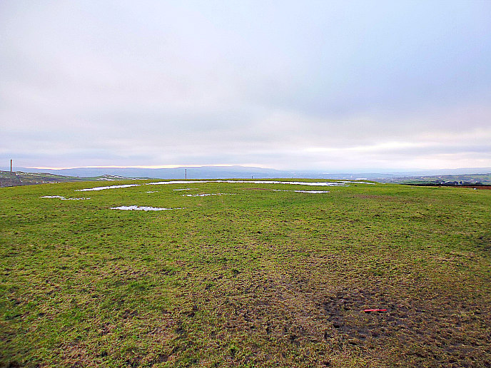
    OS grid reference: SD 84829 41718. For want of a better name I am calling this site ‘Aedmar’s Mound Earthworks’. These earthworks or ringworks are located down in a narrow valley, in a field above Blacko Water, near Wheathead Lane, just to the west of Blacko and Gisburn road, Lancashire, in the area called Admergill. A trackway heads off from Wheathead Lane at the bridge and then goes in a south-westerly direction for a short distance, and eventually through a wall stile – the earthworks are in the field (here) at the western-side of the beck – being noticeable by the grassy rectangular mound with its accompanying low ramparts, known as ringworks. These now rather forgotten earthworks may date back to the Iron-Age, or from the so-called Dark-Ages, or from the early Medieval period, but other than that we do not know when these earthworks were built or what they actually were; and they are not marked on any Ordnance Survey maps.

Aedmar's Mound / Earthworks viewed from the south-east.

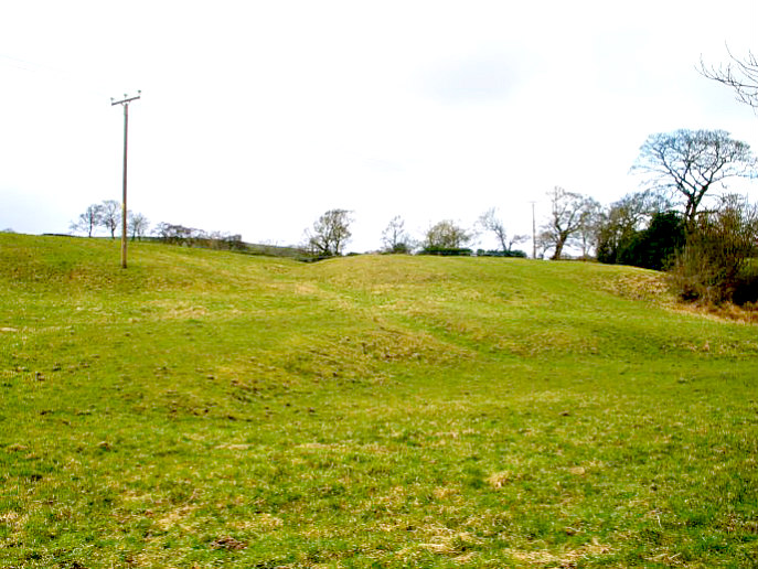
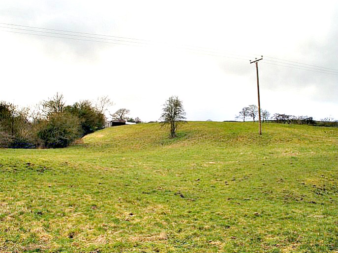
Aedmar’s Mound / Earthworks viewed from the south-east.

    The earthworks cover an area of approx. 94m across N-S and 60m diagonally W-S though the S and N sides are cut-off and damaged by the farmer’s ‘modern’ field system, while at the NW side of the site there is a continuation of the low ringwork ramparts. The rectangular-shaped low mound ‘with the telegraph pole’ is quite a distinctive shape, but there are actually two mounds here – both being intersected in the middle by a deep ditch, or entrance. So what was it exactly? Was it a camp, a hillfort, or a defended site? Or was there a settlement here or maybe a royal residence of some kind? There appears to be at least three circular ramparts or ring-works and, possibly a fourth ring by the looks of it, surrounding the low, grassy elevated mound, and the same again at the far NW side but in a sort of square-shape, which has been cut off from the main site, possibly due to farming, or that it was meant to be like this?

    Local author, John Clayton, in his fascinating book ‘Valley of the Drawn Sword’, says that Admergill could possibly take its name from: “the Welsh prince A’dd Maur who controlled certain British lands sometime in the Early Medieval period, it is very possible that this name has been shortened over time to Mawr….but equally, it could apply to the nearby settlement of Admergill…..which eventually leads to A’dd Mawr’s Gill.”

Aedmar's Mound, Blacko, with ditch through the middle.

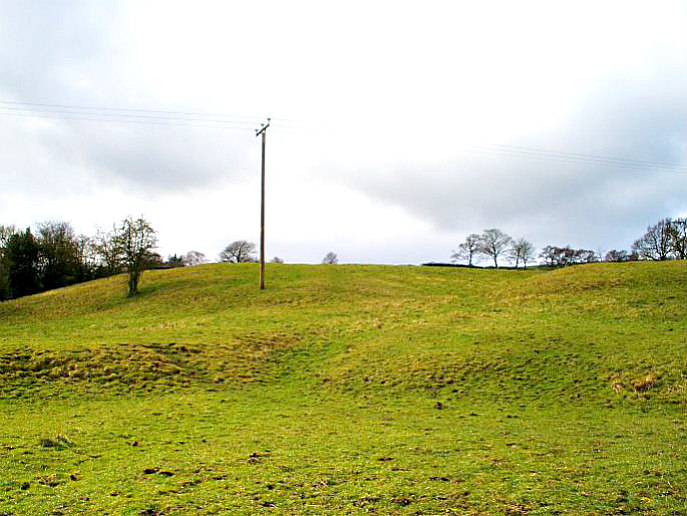
Aedmar’s Mound, Blacko, with ditch through the middle.

    But what of Aedmar and Eadmer two names that may be connected with this area, in which our ancient site lies.  St Aedmer or Eadmer was a bishop, ecclesiastic, and theologian who died in 1126, and was a friend of St Anselm. Was it “he” who gave his name to Admergill. And, there was a 7th century St Eadmer, a Northumbrian monk and disciple of St Cuthbert. But the truth is we don’t know, and probably never will – the name being lost in the mists of time. I think we should, therefore, say that the Welsh prince A’dd Mawr (Athmawr) is the more liklely contender here. He may have ruled over the Celtic (British) kingdom of Craven – Admergill being at the southern edge of this northern kingdom. And 2 miles to the north we have a farm called Craven Laithe!

    About 1 mile to the north on the southern side of Burn Moor a bowl-shaped quern stone was found, dating from 300-400 BCE (the middle Iron-Age). Grain would have been rubbed in the central depression with a small, rounded stone or pestle. In the vicinity of this discovery there were found to be a number of ancient boulders, some being built into walls (Clayton, John A, 2006).

Sources:

Clayton, John A., The Valley of the Drawn Sword – The Early History of Burnley, Pendle and West Craven, Barrowford Press, 2006.

Dixon, John & Mann, Bob, Historic Walks Around The Pendle Way, Aussteiger Publications, Barnoldswick, 1990.


2 Comments

Broadbank Earth Circle/Enclosure, Briercliffe, Lancashire

Broadbank Earth Circle / Enclosure looking through the centre N to S.

Broadbank Earth Circle / Enclosure looking through the centre N-S.

    OS grid reference: SD 90236 35225. A fairly large Iron-Age earth circle/enclosure and possible settlement, situated at 350m above sea-level, which is located at the northern end of Halifax road, overlooking Thursden Valley, near Briercliffe, in Lancashire. Sometimes called Burwains Camp. It is located at the northern end of Halifax road (High Ridehalgh), going out of Briercliffe, just before the World War II concrete pill-box. On the opposite side of the lane is a carparking area and picnic site, with beautiful panoramic views over Boulsworth Hill, but it is also easily reached coming over from Nelson past the Coldwell reservoir and Activity Centre, and turning right at the pill-box. There is not much to be seen of the earth circle/enclosure at ground-level – it is best seen from an aerial view and from that it is quite a well-defined earthwork. The site is on private farmland and is surrounded by a wall and barbed-wire. The town of Burnley is 3 miles to the south-west.

Broadbank Earth Circle / Enclosure viewed from S to E.

Broadbank Earth Circle / Enclosure viewed from  S-E.

    The large earth circle of Iron-Age date just beyond the wall measures approx. 45m vertically and 40m across, and around the perifery there is a narrow, possibly, defensive ditch-line and bank. At the NW and SE sides there has been some damage due ‘perhaps’ to farming methods, or something else. The ditch that runs through the centre of the circle and out from it may be quite recent; this was 3.5m deep when excavated, and 25cm across;  and there are still the ‘noticeable’ remains of a slight curved bank at the W, S and E sides. At the NW and N sides there are two small earth circles: 9m x 11m and 12m x 12m respectively, which could be hut circles? These connect with the large circle by way of short ditches or entrance ways, while at the E side there looks to be a “faint” outline of a medium-sized circle that is approx. 28m x 28m, but this has suffered some damage at its SE side possibly due to its closeness with the wall, past excavations, or something else.

    In 1950 the circle was excavated by The Archaeology Department of Liverpool University. A hearth was discovered at the E side, and there were numerous flint and chert flakes as well as a stone axe (4½ inches long) of Langdale origin which had a curved cutting edge and a thin rounded head and a smooth surface, but there was no evidence of polishing, according to John Dixon & Bob Mann in their book ‘Historic Walks Around The Pendle Way’.

World War II pill-box at Burwains Camp.

World War II pill-box at Burwains Camp.

    Further north along the lane at the side of a grassy mound (OS grid ref: SD 90454 35270) stands a World War II concrete pill-box, dating from about 1940. It would appear that here on this raised area of land there was some sort of camp or fort (Burwains Camp) of Iron-Age origins, and these low ramparts once formed part of that, although it is not marked as such on any OS map. The author, John Clayton, in his work ‘Valley of the Drawn Sword’, says that: “It is likely that this particular spot has been valued for its defensive nature by every culture to have graced our shores since the Neolithic period. Conflict and wars abide and over the wide span of history things do not change!”

Sources:

Clayton, John A., The Valley Of The Drawn Sword – The Early History of Burnley, Pendle and West Craven, Barrowford Press, Barrowford, Lancashire, 2006.

Dixon, John & Mann, Bob., Historic Walks Around The Pendle Way, Aussteiger Publications, Barnoldswick, 1990.

http://www.gridreferencefinder.com/

Broadbank Earth Circle, Thursden, Burnley, Lancashire.

Archaeology Department of Liverpool University, Report and Pamphlet, 1950.