Chysauster Ancient Settlement, Cornwall. B/W aerial photo.
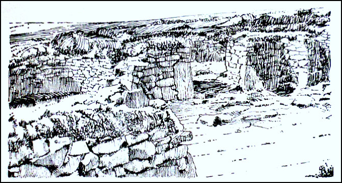
OS Grid Reference: SW 4723 3497. A few miles to the northwest of Gulval, Cornwall, lie the quite remarkably intact and restored ruins of Chysauster Iron Age settlement/village at Newmill. It is 3 miles north of Penzance. There are several oval-shaped houses with courtyards, a street and also terraced garden plots, and at the south-side a ruined underground passageway known as a fogou or souterrain. This very significant archaeological site is thought to date back, perhaps, to the 1st century BC (the Late Iron Age) and was probably still inhabited until at least the 3rd century AD (the Romano-British period). Some of the granite walls of these round houses are ‘still’ quite high and very solid despite their great age. To reach this ancient site travel northwards from Gulval village onto the B3311, and then take Chysauster Road northwest for a mile or so – looking out for Chysauster cottage on the right-hand side and the Iron Age village. There is a car park beside the lane (northwest-side of the cottage) and, a ¼ mile further up hill where the roads bends to the left, is the English Heritage site shop. There is an entry charge.
Author Jacquetta Hawkes (1975) gives us some interesting information on Chysauster. She says that: “on the west slopes of the hill [Castle-an-Dinas] is the Late Iron Age and Roman village of Chysauster, meticulously excavated and now carefully maintained. It is laid out in an orderly way with nine houses opening on a slightly curved lane in opposing pairs. The houses are of an unusual kind, known in Wales and further north but believed to be of Mediterranean origin. The principal of this domestic architecture is so utterly unlike our own that it is not easy to describe. The external outline is a rough oval, but the oval wall is immensely thick and contains within itself all the rooms, their doorways opening on to a central courtyard. In nearly all the houses the ‘best room’, oval or round in shape, is exactly opposite the narrow, roofed passage that leads into the courtyard from the lane. This larger room appears to have been thatched or turfed, but a few of the smaller cells were corbelled. Most of the floors were paved, and the larger rooms were usually furnished with hollow granite basins, presumably used as mortars; fragments of rotary querns or handmills were also found. There were serviceable drains, usually laid below the paving stones.
Chysauster Ancient Settlement, Cornwall. (Illustration).
Behind each house was a private garden, skilfully terraced and secured by an outer retaining wall of large blocks. A much-worn road led down from the village to the tin-deposits in the valley below as well as to the nearest stream. Where so much is preserved one longs to see it peopled; to know how many of them worked in the mines and how regularly; how much time they gave to their gardens: how far they were their own masters and how they marked their produce, getting the ore to the merchants who, as we are now fairly confident, shipped it from St. Michael’s Mount as the first step on the long route across France to their Mediter-ranean customers. At least it is not difficult on going into one of the Chysauster houses to see it in an Iron Age summer, the sun glaring in the courtyard where the dogs lie on the paving, the rooms dark as caves, a woman sweating as she pounds away with the heavy grindstone, small children kept safely in sight by the closed door of the passageway. All a little smelly and untidy, but not too uncomfortable and wonderfully companionable, with the eight neighbouring families, every detail known of their affairs—of expected births, betrothals, deaths; scandals, failures and achievements.”
Lord Harlech writing for H.M.S.O (1970) says of the site that: “Chysauster seems to have originated in the first century A.D., and it continued in occupation under the Roman Empire up to the third century A.D. The houses consist of oval enclosures of thick dry-built masonry, forming an open court from which various rooms open: the shape is common to other Cornish villages of this type. Chysauster and Carn Euny, like other such villages, contain a curious underground chamber known locally as a “fogou” and possibly used for food-storage. Parallels to these are found in Scotland and Ireland.”
Timothy Darvill (1988) says that Chysauster: “is an Iron Age settlement comprising a series of eight houses arranged in pairs along a street. Each house has an entrance facing east or north-east — away from the prevailing wind — thick outer walls, a courtyard immediately inside the entrance, and from three to six rooms opening from the courtyard. It is thought that animals were kept in the courtyard. The village also contains a fogou which is a long, narrow underground chamber possibly used for storing food and as a hide-out in times of unrest.” Janet & Colin Bord (1984) with regard to Chysauster say the site was occupied from the second century BC. They also say of the fogou or souterrain that “…..there is speculation regarding their purpose. Food storage or places of refuge are the most widely accepted answers; but we should not dismiss the possibility of there being some religious or spiritual reason for their construction.”
Sources and related websites:-
Bord, Janet & Colin, Mysterious Britain, Paladin Books, London, 1984.
Cunliffe, Barry, Roman Britain, The British Broadcasting Corporation, London, 1966.
Darvill, Timothy, Ancient Britain, (AA Glovebox Guide), Publishing Division of The Automobile Association, Basingstoke, Hampshire, 1988.
Hawkes, Jacquetta, A Guide To The Prehistoric And Roman Monuments In England And Wales, Cardinal, London, 1975.
Lord Harlech, Southern England, (H.M.S.O. Illustrated Regional Guide to Ancient Monuments No.2), London, 1970.
Michell, John, Prehistoric Sites in Cornwall, Wessex Books, Newton Toney, Salisbury, Wiltshire, 2003.
http://www.english-heritage.org.uk/visit/places/chysauster-ancient-village/
http://www.historic-cornwall.org.uk/a2m/rom_british/courtyard_house/chysauster/chysauster.htm
https://en.wikipedia.org/wiki/Chysauster_Ancient_Village
© Ray Spencer, The Journal Of Antiquities, 2017.
 - Grotte...")
