The Journal Of Antiquities

Ancient Sites In Great Britain & Southern Ireland


Greenberfield Lane Cup-Marked Stones, near Barnoldswick, Lancashire

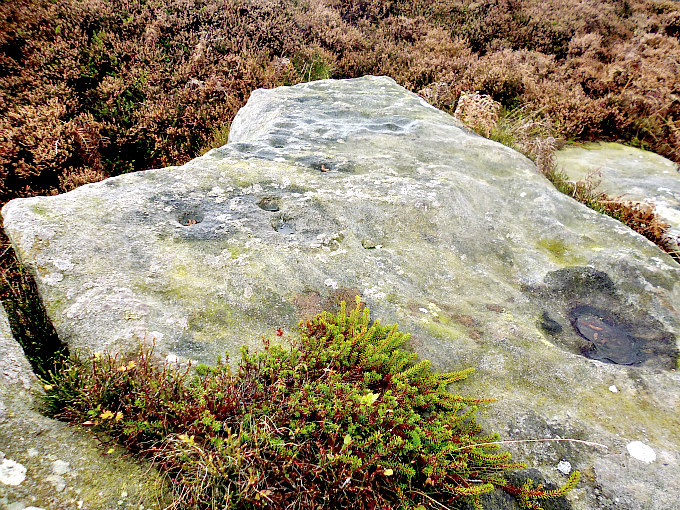
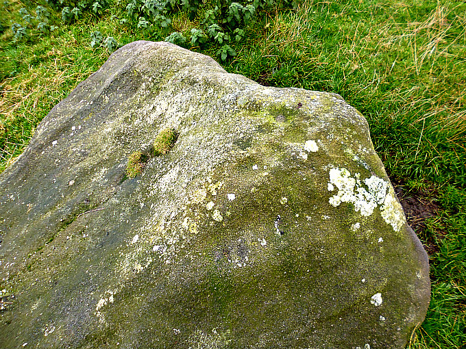
Cup-marked stone on Greenberfield Lane. Red arrow marks the spot.

Cup-marked stone beside Greenberfield Lane, Barnoldswick.

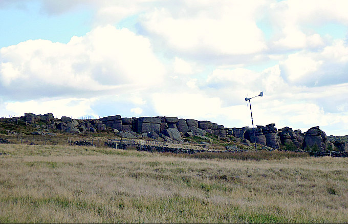
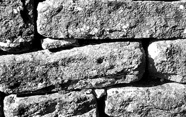
NGR: SD 8852 4806. A “new find” and “an unrecorded carving” in the wall at the side of Greenberfield Lane, near Barnoldswick, Lancashire. It is a tiny cup-mark, but it is very easily missed; and there is another “possible” cup-marked stone in the wall further along the lane on the opposite side. There is a carpark at Green-berfield Locks on the Leeds & Liverpool Canal. So where did these carved stones come from? The tiny cup-marked stone is located just past Greenberfield farm (with the large glacial erratic boulder by the side of the entrance) and the nice farmhouse (with a smaller boulder in front of it). There doesn’t appear to be a ring carving around this tiny cup-mark but, if there is it’s very, very faint, though the more I look at the photo the more I think there might be!

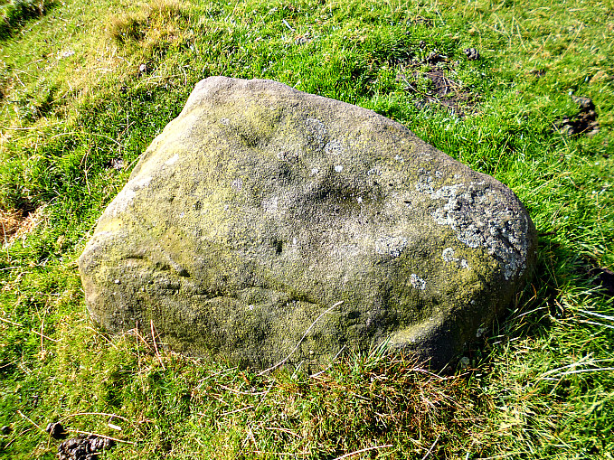
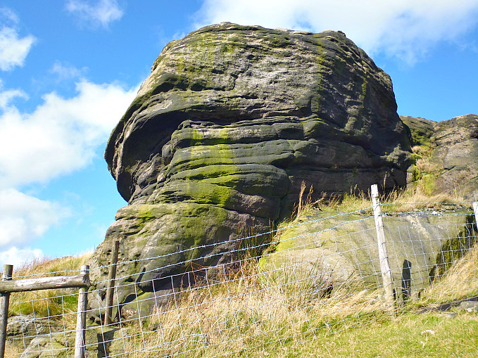
Glacial boulder beside the entrance to Greenberfield farm.

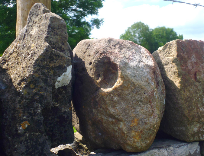
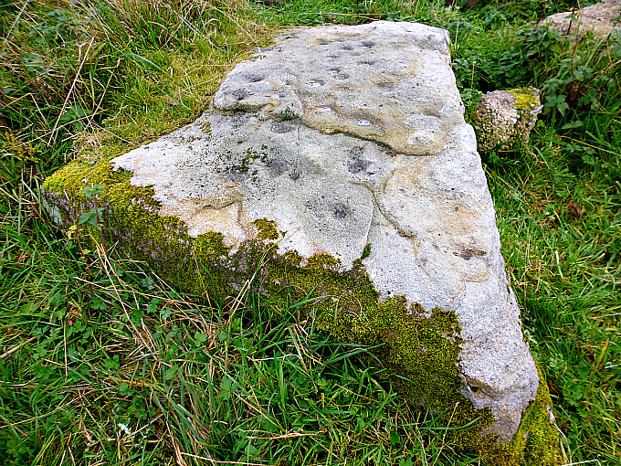
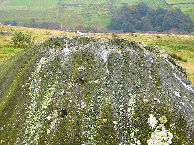
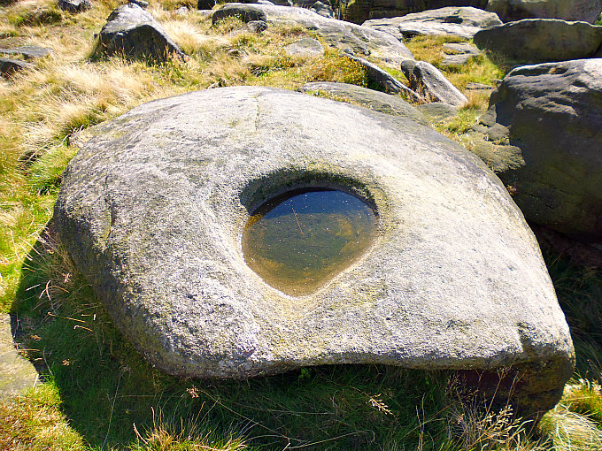
“Possible” cup-marked stone beside Greenberfield Lane,

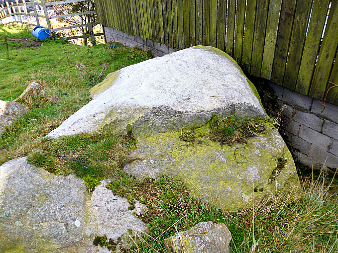
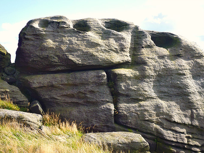
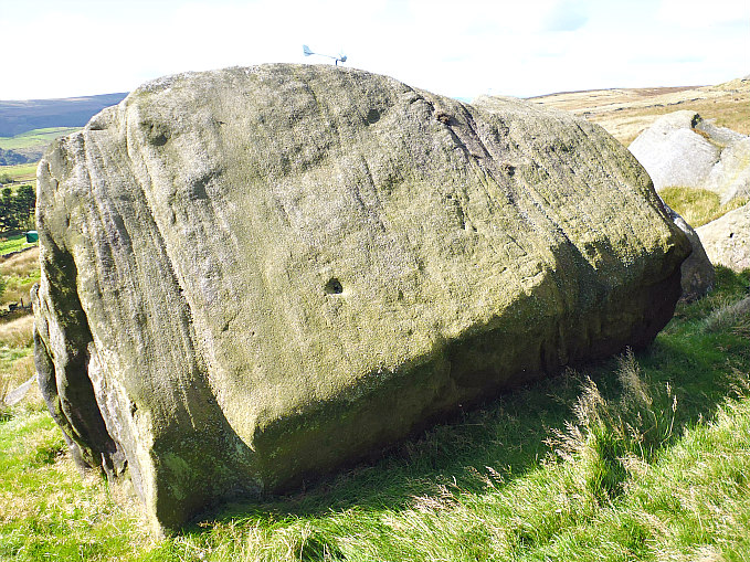
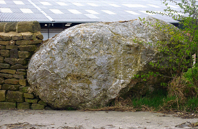
The second stone is located a little to the southwest at (NGR: SD 8847 4802) and is on the top of the wall further along on the op-posite side of the lane. This is a smooth round-shaped stone with   a well-pronounced circular hole, but whether it is a cup-mark carving is uncertain. It could be a hole left by a fossil that has dropped out, or it could be some Geological feature? At certain angles though it does look like a prehistoric cup-mark. Whatever it is, it is a very interesting stone. There are other round-shaped stones along the top of the wall. The large glacial erratic boulder (mentioned earlier, above) is between 4 and 5 foot high, and was dug out of the boulder-clay (10 foot deep) by a 13 ton digger when the new farm building (where the cows are milked) was under construction, and had not seen the light of day since the last Ice Age. The smaller boulder (in front of the farmhouse) was probably dug out of the ground around the same time. Greenberfield lies within ‘the Craven lowland drumlin field’, according to Nick Livsey.

Thanks to Nick Livsey for the above information.

https://www.visitlancashire.com/things-to-do/greenberfield-picnic-site-p561340

© Ray Spencer, The Journal of Antiquities, 2019.


Barton Cross Cup-Marked Stone, Near Preston, Lancashire

Barton Cross, near Preston, Lancashire. North-side.

OS Grid Reference: SD 53500 37332. About 1 mile to the east of Barton village on Barton Lane, near Preston, Lancashire, and at the north-side of a country lane or track running up from Barton House, is the ‘Barton Cross’, which is, sadly, an early 20th century cross that now sits in the middle of some very old stone pavings. One of these flat paving stones has prehistoric cup-marks! There are some strange lumps of stone at the side of, and also at the edges of, the surrounding base stones – which are probably from an older cross that had stood on this site in the 19th century – and which may have been of a Late Medieval date? We must though ask where did the cup-marked stone come from? Did it originate on the moors to the north, or did it come from somewhere else? You can reach the cross from Barton Village, a few miles to the north of Preston. Head east onto Barton Lane, going under the M6 Motorway, in the direction of Little Westfield and Goosenagh; the cross can’t be missed as its at the cross-roads, where the lane from Barton House emerges. 

The south-side of the cross.

The present-day ‘Barton Cross’ dates from 1901 and is a pyramidal-shaped stone on a square stone block – with a plain, chunky stone cross on top, which looks to be more recent probably in 2000. But there was at least one older cross on the site prior to this one, which might have been a late Medieval cross? We can see the original socket hole, a strange and curious lump of stone at one side, and four square stones at the edges of the flat stone-paved surround. Were these four stones, at some point in the past, supports or footings for stone posts which would have had iron chains attached to them – thus acting perhaps as a protective surround for the cross? The north-side of the monument has an inscription recording its erection in 1901 by a Preston councilor, whereas the inscription on the south-side records its refurbishment by Barton Parish Council in 2000. I understand that the large lump of stone at the side of the monument could have been an old cheese press, according to the Historic England website. The Historic England list entry number is: 1073555.

Cup-marks on one of the paving stones.

B/w photo of cup-marks on one of the paving stones.

Of much more interest, though, are the ancient cup-markings on one of the flat paved stones around the base of the Barton Cross. This has obviously been fashioned to fit into this position. There are at least 5 small but well-defined cups-marks and maybe 4 or 5 now quite faint ones.  But where did this cup-marked stone originate? Did it come from the moors to the north or northeast, or did it perhaps come from nearer to home? That we will probably never know unless someone living round here can answer that question. It is with thanks to Paul T. Hornby & TNA (The Northern Antiquarian) for discovering this ancient stone with its carvings in 2017. See TNA websites (below) for their site pages.

Sources and related websites:-

https://megalithix.wordpress.com/2017/10/12/barton-cross-barton-near-preston-lancashire/

https://megalithix.wordpress.com/2017/10/12/barton-cross-barton-near-preston-lancashire/

https://historicengland.org.uk/listing/the-list/list-entry/1073555

https://en.wikipedia.org/wiki/Barton,_Preston

© Copyright, The Journal of Antiquities, 2019.


Fish Stone (Pancake Ridge 14), Ilkley Moor, West Yorkshire

Fish Stone, Ilkley Moor, in West Yorkshire.

OS Grid Reference: SE 13468 46176. Fish Stone is a cup-marked rock on Ilkley Moor, in west York-shire, located close to Pancake Stone, and on the footpath that runs along the ridge high above Hangingstone Lane and the Cow & Calf Hotel. For want of a better, proper name, which it might have, but at the moment I can’t find it – I have given it the name: ‘Fish Stone’.  However, I “now” know it to be called ‘Pancake Ridge 14’ because it is to be found on that ridge of high ground and opposite the curiously shaped ‘Pancake Stone’, which also has some cup-markings on its top surface. The stone is, at a certain angle, shaped like a fish though I’m sure there are other rocks on the moor that bear that same similarity. The stone has been recorded by Boughey & Vickerman as (338) and by Era as (Era-2564). For directions to the Fish Stone (Pancake Ridge 14) please see the site page for ‘Haystack Rock’: https://thejournalofantiquities.com/2017/10/27/haystack-rock-ilkley-moor-west-yorkshire/

Fish Stone, Ilkley Moor, from a different angle.

Fish Stone, Ilkley Moor, from yet another angle.

The ‘Fish Stone’ is one of three flat stones here, only the middle one having well-defined pre-historic cup-marks (petroglyphs) on its surface; if there are any on the other two stones they are now faint and worn. There looks to be around 17 cup-markings in the middle and towards the edges of the stone although a some of these may be natural as is the depression at the far side which is due to erosion. Most of the cups are quite small and now fairly worn but they are still visible. There don’t appear to be any rings? But nobody seems to know what these cup-markings are meant to signify – could they be just the idle doodlings of our Bronze Age ancestors, or could they actually be maps showing stars in the night sky, or maybe maps showing burial sites, springs, settlements and other nearby carved rocks; we don’t know with any certainty, so they must therefore remain something of a mystery and ‘an enigma’. If we could travel back in time we could ask the carver of the cups-and-ring markings what he was doing, why he was doing it, and what they were meant to signify. But that’s one for the future!

Sources and related websites:-

https://www.megalithic.co.uk/article.php?sid=48988&m_distance=0.0

https://archaeologydataservice.ac.uk/era/section/panel/overview.jsf?eraId=2564

https://archaeologydataservice.ac.uk/era/section/panel/media.jsf?eraId=2564

https://megalithix.wordpress.com/2009/01/25/pancake-stone-ilkley-moor/

© Ray Spencer, The Journal of Antiquities, 2019.


3 Comments

Farnhill Moor Cup-Marked Rocks, Near Skipton, North Yorkshire

Cup-Marked Rock on Farnhill Moor, near Skipton, North Yorks

Cup-Marked Rock on Farnhill Moor with 40 cup-markings.

OS Grid Reference: approx. SE 0064 4710. On Farnhill Moor above the north Yorkshire villages of Farnhill and Kildwick, 3 miles to the southeast of Skipton, there is a little cluster of ancient cup-marked carvings on some gritstone rocks. These carvings or petroglyphs are rather hidden away by the undergrowth at the south side of Jubilee Memorial, a white monument with a stone cross. One of these large rocks has four large cup-marks while the rock above it on the craggy ridge has forty or so quite distinct cup-marks. From Main Street in Farnhill take the narrow Crag Lane uphill for a little while, then when reaching the wooded area on the right take the path going east. After a short distance veer off to the north to meet up with a well-defined footpath heading towards the Jubilee Monument. Just downhill from the monument walk east into the often dense undergrowth towards the craggy ridge. Here amongst these gritstone rocks you will have to search around to find the carvings, but it will be well worth it in the end!

Cup-Marked rock on Farnhill Moor, near Skipton, North Yorks.

Farnhill Moor Cup-Marked Rock showing 4 cups on the side and 2 more cups above.

On the edge of a large gritstone rock, just below the craggy ridge, are four large distinct cup-marks (petroglyphs) and above those possibly a couple of tiny cups. These cup-marks are very easily missed and not that easy to photograph, unless the sunlight is just right and not shining right at you. You will notice the gritstone rock has turned almost white which is due to rain over thousands of years. On the ridge above, another large rock jutting out from the crag has on its face forty or more very well-defined cup-marks, some small cups and some larger ones, which have ‘become larger’ maybe due to erosion over 4,000 thousand of years or more. There are a few small cup-marks away from the main panel. We don’t really know what these cup-marks mean, or why they were carved, and so they must remain something of an enigma. It’s very likely, however, Bronze Age people had their settlements on these very moors at a time when the climate was much milder in winter than it is nowadays. To the northwest on Low Bradley Moor lie the stone-strewn remains of two cairns where the Bronze Age people buried their chieftains.

Jubilee Monument.

The Jubilee Monument also called Jubilee Tower or Pinnacle was erected in 1887 to celebrate Queen Victoria’s Golden Jubilee. This white painted, bottle-shaped monument is 12 foot high and atop the edifice there is a carved stone cross. The monument is covered with Victorian inscriptions, but there is also more recent graffiti. It is thought to have replaced an earlier cairn indeed some think this was a burial cairn, similar perhaps to those that date from the Bronze Age which can still be seen over to the northeast on Low Bradley Moor, although there are now only large piles of stones strewn around in a sort of circular fashion. (See below for further details).

Sources and related websites:- 

https://en.wikipedia.org/wiki/Farnhill

https://thejournalofantiquities.com/2016/04/10/bradley-long-cairn-farnhill-north-yorkshire/

http://www.farnhill.co.uk/farnhill-history.html

© Ray Spencer, The Journal of Antiquities, 2017.      


Dragon Stone, Near Steeton, West Yorkshire

Dragon Stone - cup-marked rock near Steeton, west Yorkshire

Dragon Stone (cup-marked rock) near Steeton, west Yorkshire

    OS grid reference: SE 03604 03695. In a farmer’s field above Little Snowden Hill, near Steeton, west Yorkshire, there is a cluster of rocks in an area of rough ground which have prehistoric cup-marks, one of these rocks being locally known as ‘Dragon Stone’. And in the next field along there is another cluster of rocks which also look to have faint cup-marks. This so-called ‘Dragon Stone’ has several quite prominent little cups and there are also some grooves which may be part of the carvings here. However these carved rocks are on private farm-land and there is no designated footpath. To reach the rocks you “might” be able to walk along the overgrown track leading off from Hollins Bank Lane, nearly opposite the entrance to Tower Farm, if the wooden gate opens? Walk along the track past the house and barn of Hollins Bank Farm, then soon after the wooded area you’ll need to via off across the field to the south for 90m beyond the first field wall. Otherwise, you’ll need to find another way of reaching the site from the lane, if that’s possible?

Dragon Stone, near Steeton, west Yorks.

Dragon Stone, near Steeton, west Yorks.

Cup-marked rock opposite Dragon Stone.

Cup-marked rock opposite Dragon Stone.

    In the corner of a farmer’s field above Little Snowden Hill there is an outcrop of gritstone rocks, or a cluster of rocks maybe. One of these known as ‘Dragon Stone’ bears many ancient cup-markings (rock-art). There are as many as 20 cup-marks on the this worn, flat rock, and around the sides and in the middle there are faint grooves running in a sort of circular fashion, but whether these were caused by erosion, or whether they are part of the carving, is not really known; and there is a crack in the rock which adds to the strange look of the stone. And why it is locally called ‘Dragon Stone’ is not known, although the rock might take on the look of a dragon at certain angles. On another rock, just opposite, and close by the wall there are a few more cup-marks, maybe up to 4 or more, although these can only be seen in a certain light and at an angle. This rock also has one or maybe two faint bowl-shapes made by erosion though these are often hidden away under a layer of lichen and grass. In the field beyond the wall (at SE 0354 4360) another cluster of rocks, one of which at least shows signs of a few faint cup-marks?

Sources and related websites:-

https://megalithix.wordpress.com/2010/09/04/dragon-stone-steeton/

https://megalithix.wordpress.com/2010/04/10/bowl-stone-steeton/

https://en.wikipedia.org/wiki/Steeton,_West_Yorkshire


Cob Stone, Near Far Slippery Ford, Newsholme Dean, West Yorkshire

Cob Stone near Grey Stones Lane, Far Slippery Ford.

Cob Stone near Grey Stones Lane, Far Slippery Ford, west Yorkshire.

    OS grid reference: SE 00549 40890. In a field beside Grey Stones Lane and below an outcrop of rocks called Grey Stones Hill, near Far Slippery Ford, west Yorkshire, is a gritstone rock that is locally called Cob Stone. Whether it takes its name from a small round loaf of bread, or some-thing else, I don’t know with any certainty, but I am also told that the word “Cob” means ‘Devil’ in this part of the country, so it could mean “Devil’s Stone”. The rock has a cluster of quite well-defined cup-marks on top and maybe a few fainter cups-marks lower down. To reach the stone you can take the footpath going east from Long Gate Lane at Far Slippery Ford. This will bring you to the bottom of the field. Other than that, you could see if the wooden gate opens on Grey Stones Lane next to the track going down to Grey Stones Farm. If it opens, then please make sure it is secured after entering, and on going back out again!

Cob Stone, beside Grey Stones Lane (cluster of cup-markings).

Cob Stone, beside Grey Stones Lane (cluster of cup-markings).

Large boulder near Cob Stone (with pos- sible cup-markings)

Large boulder near Cob Stone (with “possible” cup-markings).

    Cob Stone or Devil’s Stone is a glacial erratic gritstone rock that was deposited by a retreating glacier many thousands of years ago at the end of the last Ice Age. On top of the stone there is a cluster of 7 or 8 small cup-marks and further down a few fainter cups can just be made out. However, these faint cup-marks might have been caused by erosion – it’s often difficult to tell one way or the other, and the rock itself is now very smooth on its side due to thousands of years of weathering. Some 68m to the south-west there is an even larger boulder; maybe it’s another Cob Stone?, and this is indeed roughly shaped like a loaf of bread! This large boulder looks to have a few cup-marks on top and on its side, or are these due to erosion? And there are a few other rocks in the same field that have “possible” cup-markings; it’s just a case of walking around and looking closely at the many small and large rocks, and there are indeed “many” to look at. Cob Stone is recorded in Boughey & Vickerman’s  2003 survey.

    And of further interest to the lover of rock-art is another large rock some 80 metres to the south-east. This can be found at the north side of the large barn belonging to Greystones Farm. See the link below:-

Cup-Marked rock in the field near Cob Stone.

Cup-Marked rock in the field near Cob Stone, Grey Stones Lane near Far Slippery Ford.

Stone near Cob Stone (possible faint cup-marks)

Stone near Cob Stone at Grey Stones Lane, Far Slippery Ford (possible faint cup-marks)


Sources and related websites:-

https://megalithix.wordpress.com/2008/09/29/cob-stone/

https://thejournalofantiquities.com/2016/10/13/greystones-farm-cup-marked-rocks-near-newsholme-dean-west-Yorkshire/

                                                                            © Ray Spencer, The Journal Of Antiquities, 2016.


Greystones Farm Cup-Marked Rocks, Near Newsholme Dean, West Yorkshire

Greystones Farm Cup-Marked Rock (beside the large barn).

Greystones Farm Cup-Marked Rock (beside the large barn).

    OS Grid Reference: SE 00621 40844. Located beside the large barn of Greystones Farm, on Greystones Lane, is a gritstone rock which has several prehistoric cup-marks. A few other rocks is the same field also appear to have faint cup-marks, and one of these large rocks, locally called Cob Stone, also has “possible” cup-marks. Just above the farm there is an outcrop of gritstone rocks called Greystones Hill. The farm is a ¼ of a mile north of Far Slippery Ford, and the hamlet of Newsholme Dean is about 1 mile to the east on Todley Hall Road. To reach the site travel down Long Gate, then onto Coppy Lane and then Greystones Lane. Walk down the rough farm-track towards Greystones Farm, making sure the wooden gate is secured behind you. Via off the track to the large barn on the left – the cup-marked stone is beside this barn. You can also reach it via the footpath from Long Gate at Far Slippery Ford.

Greystones Farm Cup-Marked Rock (beside the large barn).

Greystones Farm Cup-Marked Rock (beside the large barn).

Greystones Farm Cup-Marked Rock (close up)

Greystones Farm Cup-Marked Rock (close up)

    Located at the north side of  Greystones Farm barn is a  large, weathered gritstone rock bearing several well-defined ancient cup-marks: as many as 15 tiny cups on the flat face of this soft rock. What these carvings represent we don’t really know: maybe they represent a sort of map of the stars, or they are just ancient graffiti or doodlings, or they are a map showing ancient springs, caves, or trackways.  Or do they perhaps represent something  else.  The whiteness, or greyness, of the rock is caused by weather related exposure over thousands of years – the exposed parts of the rock have been washed by rain to the colour that we see today, and so we have “greystones” which is sometimes spelt as “graystones”. A few of the larger rocks up the slope of the same field appear to also have cup-marks, although now very faint. One stone in particular called Cob Stone, near the top of the field at the other side of the track (SE 00553 40888) has eroded cup-marks on top. These cup-marked rocks were recorded and numbered by Boughey & Vickerman in their survey of 2003. (See The Northern Antiquarian link below).

Sources and related websites:-

https://megalithix.wordpress.com/2008/09/29/cob-stone/

http://www.pastscape.org.uk/hob.aspx?hob_id=1084602

                                                                   © Ray Spencer The Journal Of Antiquities.


1 Comment

Hawks Stones, Stansfield Moor, Near Todmorden, West Yorkshire

Hawks Stones (as seen from Kebs Road, near Todmorden).

Hawks Stones (as seen from Kebs Road, near Todmorden).

Hawks Stones, near Todmorden (strange shaped rocks).

Hawks Stones, near Todmorden (strange shaped rocks).

    OS grid reference: SD 9233 2735. A gritstone outcrop at the western edge of Stansfield Moor above Kebs Road, near Todmorden, in west Yorkshire. Like its near neighbour, Bride Stones, Hawks or Hawk Stones has many strange-shaped weather worn rocks and boulders that were first laid-down many millions of years ago, and then fashioned by a retreating glacier during the last Ice Age – some 13,000 to 15,000 years ago. There are the usual naturally-formed rock basins, and a few of the larger boulders appear to have ancient cup-marks, although it is often hard to differentiate between erosion-related holes and man-made rock-art. To reach Hawks Stones take the footpath from Kebs Road going east up the slope near the “old” Sportsman public house, then after 60m follow the ridge – going north-north-east to where you will soon reach the gritstone outcrop. However, the farmer has put up a lot of barbed-wire fencing, which makes it difficult, if impossible, to access some parts of the site.

Possible cup-marked rock at Hawk Stones, near Todmorden.

Possible cup-marked rock at Hawks Stones, near Todmorden.

Rock basin at Hawks Stones, near Todmorden, west Yorkshire.

Rock basin at Hawks Stones, near Todmorden, west Yorkshire.

    Hawks or Hawk Stones over to the east of Todmorden is an outcrop of millstone grit rocks and boulders that have taken on the form of some strange and odd shapes over many thousands of years; the erosion caused by weathering has added to the general eerie look of the place, which has, perhaps, been associated with the druids and their ritual and sacrificial worship back in the mists of time. The many rock pools and basins that are worn into the rocks maybe adding to that strange, mysterious feeling that one gets when visiting these lonely, moorland places. Some of the larger rocks and boulders look to have “possible” prehistoric cup-marks, some being more pronounced, while others are much more fainter. Or could these have been made by weather-related erosion over thousands of years? The place-name Hawks or Hawk Stones is thought ‘not’ to be associated with, or named after, the bird of prey!

    The Local author Geoff Boswell in his book ‘There and Back’, thinks that Hawk Stones are well-named: “because this area is the natural habitat of many moorland birds.”

Hawks Stones (naturally formed rock basins).

Hawks Stones (naturally formed rock basins).

Hawks Stones (possible cup-marks, or something else).

Hawks Stones (cup-marks, or something else).

    Author Paul Bennett in his outstanding work ‘The Old Stones of Elmet’, says that Hawk Stones are: “Illustrated on the 1717 Greenwood map, this huge outcrop of rocks was first described as “druidical” by Watson (1775), by inference to the local folklore of them being sites of ancient worship—which they may well have been. These sentiments were later echoed by Crabtree (1836). Then in 1864, the historian and folklorist, Thomas Wilkinson, gave a lecture to the Lancashire and Cheshire Historical Society, where he drew attention to the folklore of  these rocks. He was particularly interested in the “druidical rock basins” carved atop of some of them—or cup-and ring stones. The etymology of the site relates to “hollows” and not hawks as its name implies, which may be a description of such basins.”

Sources and related websites:-

Bennett, Paul, The Old Stones of Elmet, Capall Bann Publishing, Milverton, Somerset, 2001.

Boswell, Geoff, There and Back, Delta G, Todmorden, 2000.

http://www.walkingenglishman.com/westyorkshire02.htm

https://thejournalofantiquities.com/2016/08/31/the-bridestones-near-todmorden-west-yorkshire/

                                                          © Ray Spencer, The Journal Of Antiquities.