The Journal Of Antiquities

Ancient Sites In Great Britain & Southern Ireland


Boadicea’s Grave, Hampstead Heath, Greater London.

Queen Baodicea and her daughters riding their chariot into Roman Londinium.

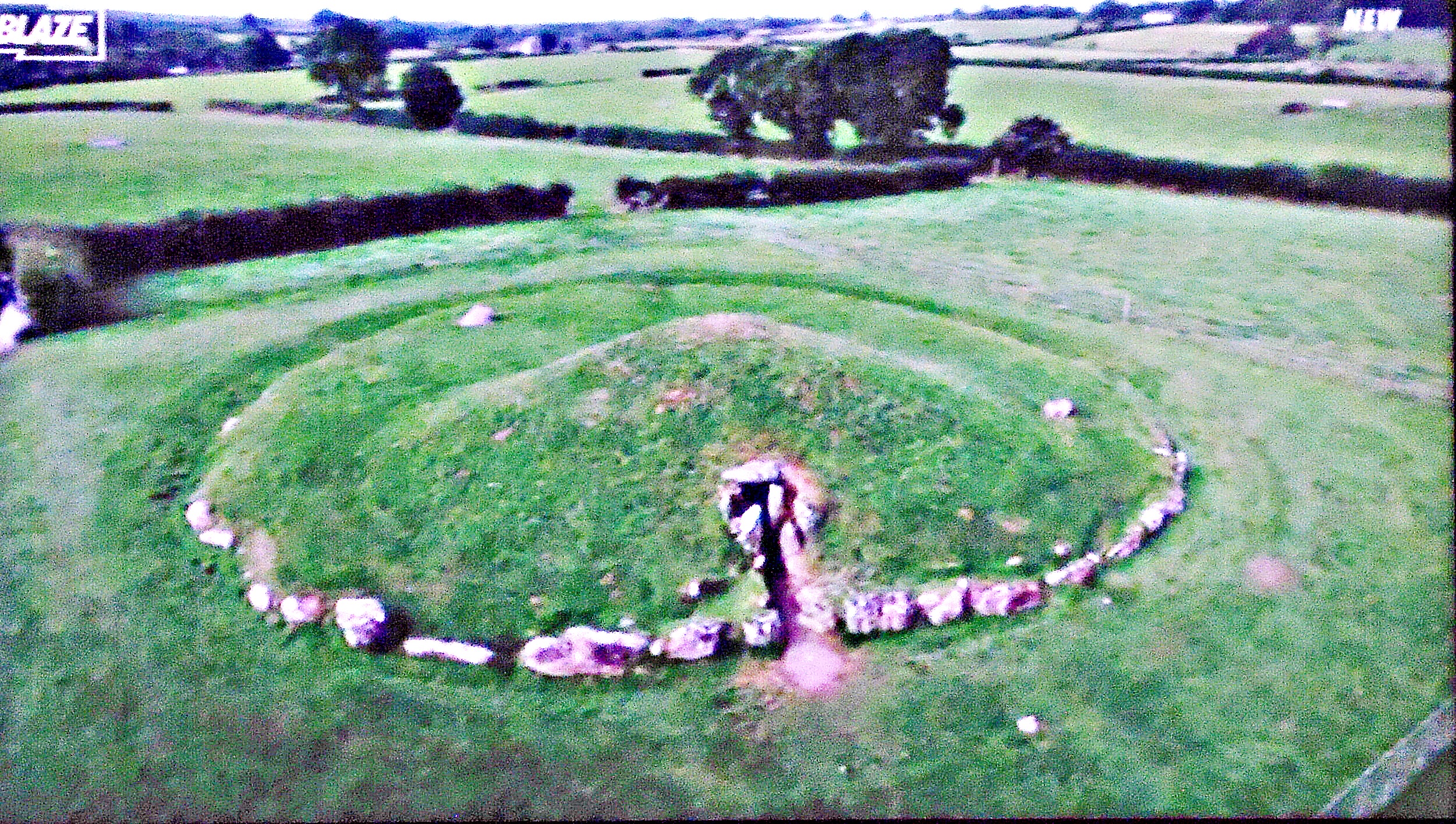
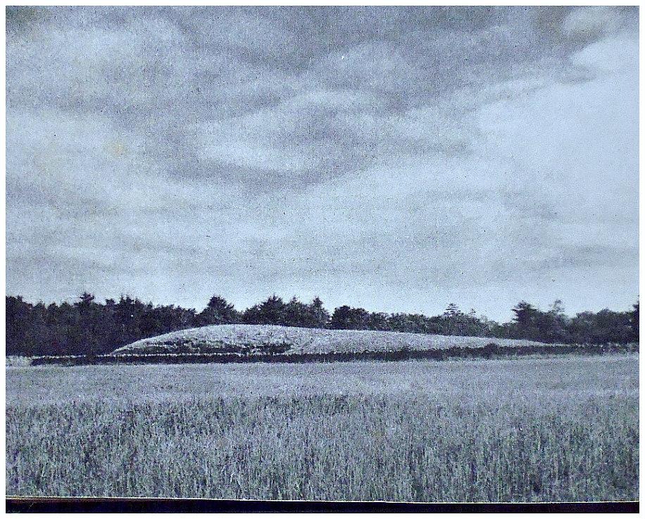
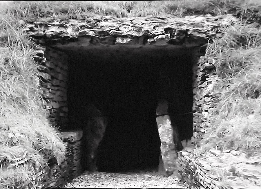
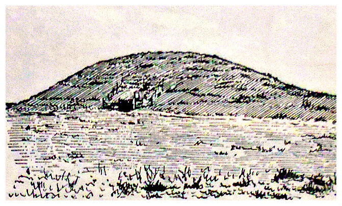
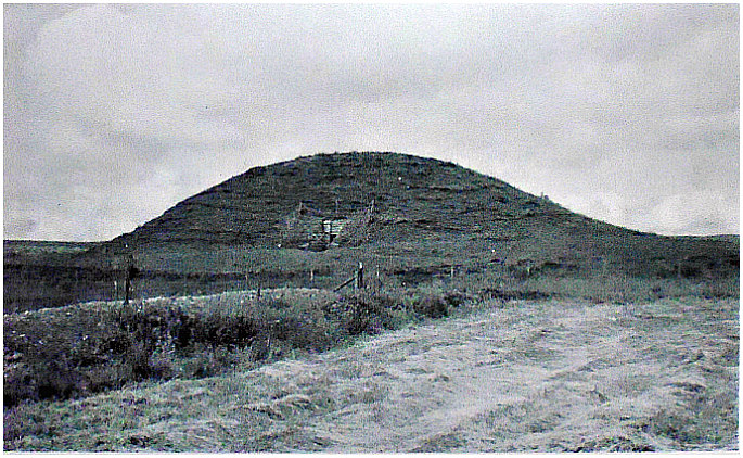
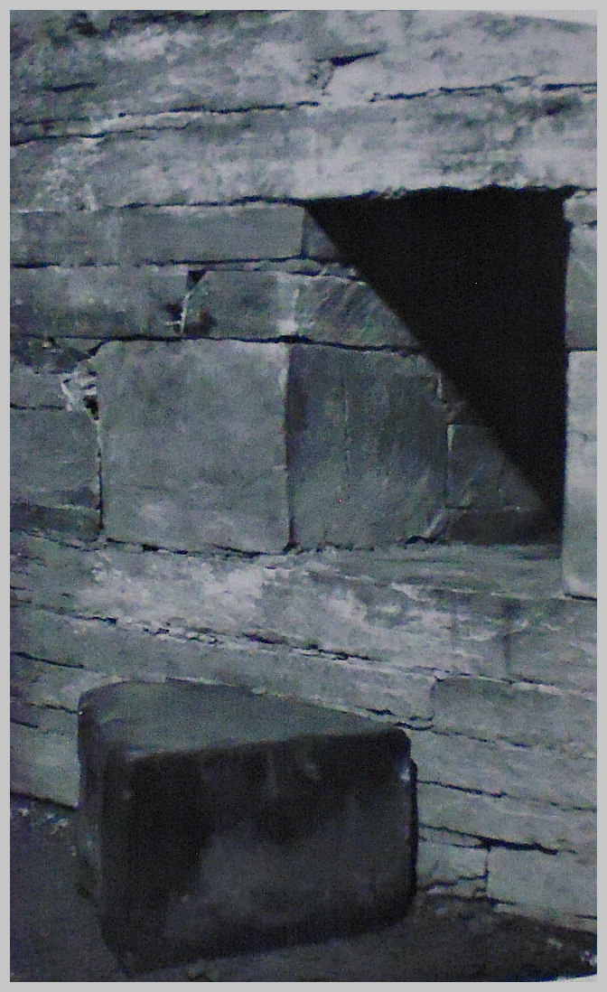
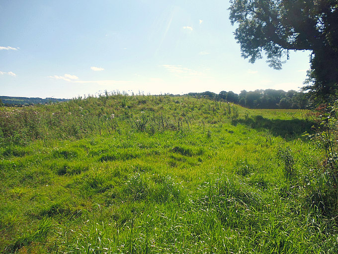
NGR: TQ 27382 86518. A large Bronze Age bowl burial mound on Hampstead Heath, Greater London, which has trees and bushes growing from it and railings surrounding it, was tradi-tionally called ‘Boadicea’s Grave’, however, this often given assumption is considered to be a myth and has no historical association with Boadicea or Boudicca, Queen of the Iceni. She was the widow of King Prasutagus, who died in late 59 or early 60 AD. The circumstances of Boadicea’s death, the place of her death, and the place of her burial sometime around 61 AD is not known (some historians put her death a few years later on) although several theories have been put forward as to where she was buried in Londinium and further afield, though without any real evidence to back up those claims. Did she: take her own life? was she killed by a Roman soldier? was she poisoned? did she succumb to ill health or did she escape alto-gether, never to be seen again? – in truth though, these questions cannot be answered and probably never will be answered, but she is almost certainly not buried in the ancient tree-covered mound on Parliament Hill (Hampstead Heath) which predates her by 1,000 years or more. A second mound close by was built in the last few hundred years and was probably the site of a fire beacon.

Hampstead Heath is 4 miles northwest of the city. A very splendid bronze monument-cum-statue of the Celtic warrior Queen Boudicca stands on the Embankment close to Westminster Bridge in London, where she is shown riding her horse-drawn chariot with her two daughters at her side, and scythes on its wheels! This statue group was made in the late Victorian age, but not erected until 1902. The Latin form of her name was always written by Roman writers as BOUDICCA.

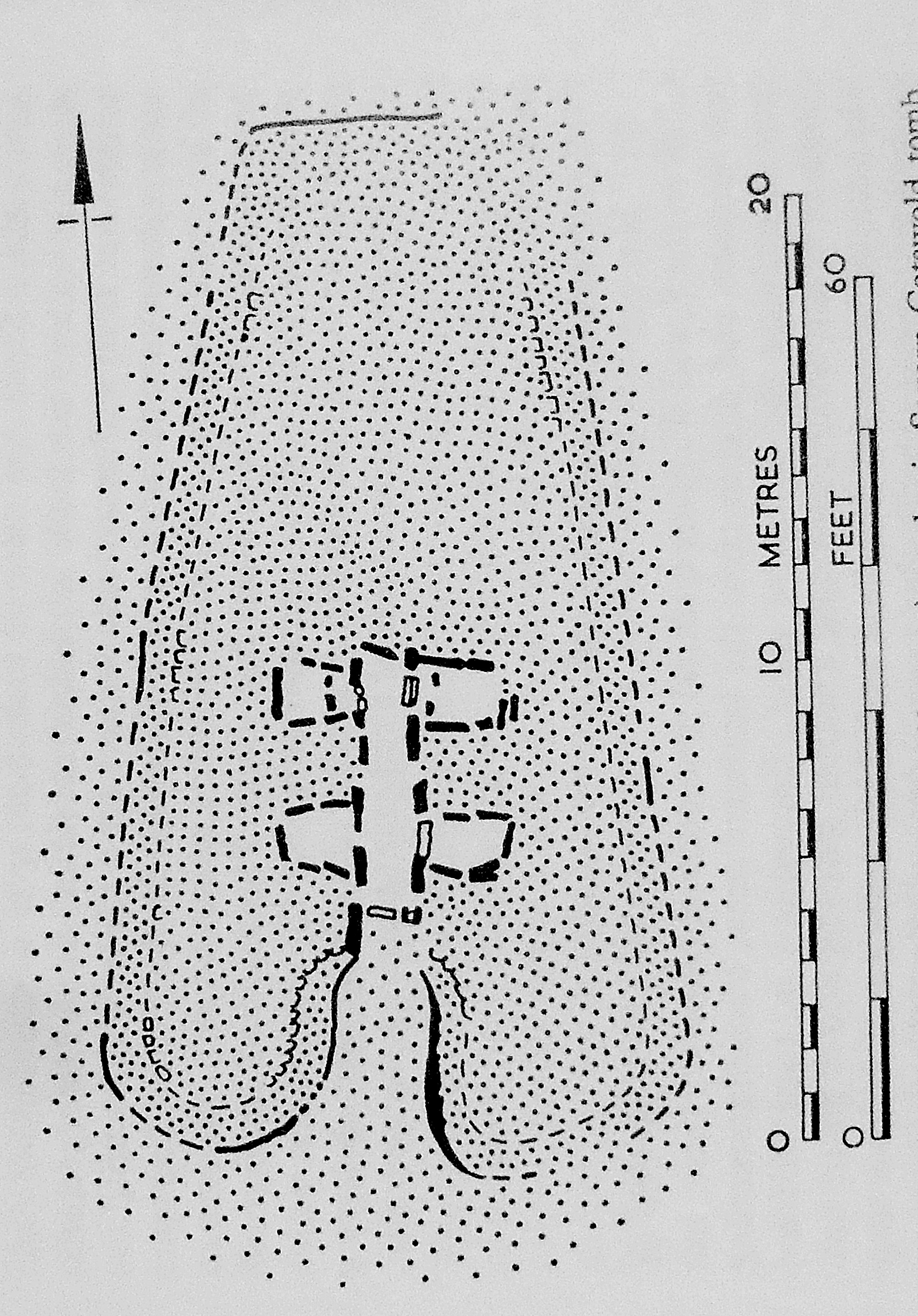
James Dyer writing in 1977 says of the barrow on Parliament Hill, Hampstead Heath, that it is: “Covered by bushes, halfway between Hampstead Ponds and Highgate Ponds. This barrow, now obscured by bushes and enclosed by iron railings, is about 41 m in diameter and 2.4 m high, with an encircling ditch about 4.9 m wide. In 1894 Sir Hercules Read trenched the mound but found nothing in it.  Some doubt has been cast on its antiquity, but a sketch made by Stukeley in May 1725 leaves little room for scepticism. His drawing clearly shows a causeway across the ditch on the north side, and another is reported on the south.”

Similarly, perhaps, ‘The King’s England — London’ tome from 1949 gives the following information on Boadicea’s Grave: “To the north stretch Parliament Hill Fields, the glorious extension of Hampstead Heath with hundreds of acres of grassy parkland. From the top of the hill, 320 feet high, is an extensive all-round view. with the churches of Hampstead and Highgate, and the Surrey hills across the Thames. A short distance from the summit is the little artificial hill called Baodicea’s Grave, now hidden in trees and undergrowth. It is 10 feet high and nearly 40 yards across, and is surrounded by a dry ditch. It is thought to be a grave of the early Bronze Age, and thus about 4000 years old. The mound on the north side has been added in the last two centuries, and was probably formed by beacon fires.”

Geoffrey Ashe wrote in 1993: “Boudicca’s campaign was not an act of resistance to conquest, but a reaction after the event. Her career illustrates the equality of Celtic queens, and their ability to take charge and command armies. Her name, perhaps an assumed one, means ‘Victory’, and her attachment to the war-goddess Adraste may hint at a religious quality in her leadership. She is described as tall, fierce-looking, and harsh-voiced, with a mass of red hair down to her waist.

“Her personal grievances are obvious, and so are her public ones, since the Romans made it plain that they were annexing her territory and not letting her continue as queen. She could enlist the Trinovantes – no longer subject to the Catuvellauni — because of the Romans’ treatment of Camulodunum in the course of its transformation into Colchester. Army veterans seized land by evicting Britons in possession, and the authorities extorted money and labour for a building programme such as no Briton could have foreseen……”

Ashe goes on to say: “Boudicca, therefore, exploited the indignation of the whole of East Anglia, a populous area. Late in the year 60 AD, probably, a horde of Britons under her leadership destroyed Colchester. The Roman forces in Britain were divided, and she captured London and Verulamium, burning both to the ground and massacring thousands, not only Roman but British collaborators. Rome’s historians take her triumphs no further, but there are archaeological hints of outbreaks beyond. 

“The governor, Suetonius Paullinus, was away in Anglesey stamping out Druids. During 61 he managed to assemble ten thousand men, and stationed them in a well-chosen spot, partly enclosed by hills and woods that nullified the Britons’ advantage in numbers. Its location is doubtful. One suggestion puts it near Towcester, in Northamptonshire; another near Mancetter between Nuneaton and Atherstone. The queen attacked, but Roman discipline prevailed and the Britons were routed. Her suicide may well be historical, and there is certainly no clue to her grave. The King’s Cross theory is due to Lewis Spence, who conjectured that she fought her last battle on the future site of the station.

“Paullinus carried out ruthless reprisals. However, his treasury officer Classicianus was a Gaul with ideas about Romanisation. Under his influence the regime grew milder, and the Britons, those of the upper classes at least, were largely reconciled and assimilated.” 

The idea that Queen Baodicea was buried at Stonehenge in Wiltshire is a myth as is King’s Cross railway station in London, where it has been suggested by some that her body lay beneath platforms 8, 9 or 10! It’s possible the Queen’s body was taken back to her native East Anglia and cremated and buried somewhere in Norfolk.

Sources/References & Related Websites:-

Ashe, Geoffrey, Mythology Of The British Isles, Methuen, London, 1993.

Dyer, James, Southern England — An Archaeological Guide, Faber And Faber Limited, London, 1977.

Richmond, I. A., The Pelican History Of England — Roman Britain, Penguin Books Limited, Harmondsworth, Middlesex, 1963.

The King’s England, London — Heart of the Empire and Wonder of the World,  Hodder And Stoughton, London, 1949.

https://www.megalithic.co.uk/article.php?sid=4724

https://en.wikipedia.org/wiki/Boudica

https://www.historic-uk.com/HistoryUK/HistoryofEngland/Boudica/

More info here:  https://www.visitnorfolk.co.uk/post/romans-boudicca-and-the-iceni-in-norfolk

Copyright © Ray Spencer, The Journal of Antiquities, 2024.


Parc Le Breos Long Barrow near Parkmill, Gower, South Wales

Parc le Breos (Parc Cwm) Long Barrow, near Parkmill, Gower.

NGR: SS 5373 8984. At the southern side of the wooded Green Cwm (valley) close by a public footpath, ¾ of a mile to the northwest of Parkmill (Melin-y-Parc), Gower Peninsula, South Wales, is the Neolithic chambered long barrow called ‘Parc le Breos’, which is also known locally as ‘Parc Cwm Long Cairn’ and ‘the Giants’ Grave’. This particular long barrow has long since lost its earthen mound and now only its inner structure is displayed with a stone-lined passageway and two pairs of burial chambers or cells open to the skies. There is a bell-shaped, deep-horned forecourt at the front of the monument, while at the sides of the passageway there are upright stone slabs, although a few of these at one side now lean slightly inwards at angles. Around the sides of the monument traces of the tomb’s earthen mound can still be seen. The long barrow was excavated twice in the 19th century at which time the bones of many individuals were recovered. A  partial restoration by the Ministry of Works took place in the early 1960s. This 60-foot-long ancient barrow is described as bearing the structural features of the Severn-Cotswold Group of monuments from the Neolithic Age. The site, which is 2 miles to the southwest of Ilston and around 2½ miles north of Penmaen, is in the care of CADW (Welsh Historic Monuments).

Timothy Darvill writing in 1988 about the site in Gower says: “This partly restored middle Neolithic long barrow constructed in the Cotswold-Severn tradition stands on the floor of a narrow leafy valley well away from the busier parts of the Gower coast. The most striking feature of the site is the characteristic wedge-shaped cairn, reverted all round by a fine dry-stone wall. It is constructed of limestone rubble and today looks very much like it must have done in Neolithic times because the bare rock has not yet been colonised by grass and flowers.  At the southern end of the cairn is a bell-shaped forecourt flanked by broad horns. Part of the eastern horn was disturbed by a river flowing past the site at some time since the Neolithic period. The entrance to the burial chambers lies at the back of the forecourt; there are two pairs of side chambers leading off a central passage. Large orthostats form the walls of the passage and chamber but unfortunately the roof was removed in antiquity and has not been restored. Excavations in 1869 recovered the remains of between 20 and 24 individuals from within the chambers.” 

Plan of Parc le Breos Chambered Tomb, Gower, South Wales.

Jacquetta Hawkes writing in 1973 tells us that: “The Gower Peninsula. a charming piece of coast beyond the infernal industrial regions of Swansea, is for its size well endowed with antiquities. Of these the most important and the most spectacular is Parc Cwm, Penmaen, near the centre of the promontory. This monument has a deep forecourt and a gallery with two pairs of side cells very much like the early Cotswold long barrow; the cairn on the other hand is a stumpy oval and appears never to have been long. It has been suggested, therefore, that Parc Cwm is a hybrid architectural form between the Cotswold style and that of the megalith builders of the western Atlantic coasts who, as we shall see, often covered their chambers with round or oval cairns. There are, indeed, two other burial chambers with rounded covering mounds on the Gower Peninsula—the two Sweyne’s Howes, sometimes incorrectly called Swine Houses, on the Rhossili hills near the western extremity. There are two other tombs in the Peninsula which are well worth seeing; one, a gallery with side cells like a smaller version of the Parc Cwm chamber, is masked by the blown sand of Penmaen Burrows behind Oxwich Bay; the second, Maen Cetti or Arthur’s Stone, Reynoldston, is an exposed megalithic chamber with an enormous capstone weighing some twenty-five tons.”

Bill Anderton writing in 1991 says: “This passage tomb is in an excellent state of preservation and is one of the finest to be found in Wales. Excavated in 1869 and again in 1960-1, the remains of twenty bodies were found in the various chambers along with some fragments of Neolithic pottery. The tomb is approached along a track from Parkmill. It is oval in shape, measuring approximately 18 metres by 15 metres. The passage inside is about 5 metres long with small chambers on each side. Take the main road from Swansea , the A4118, and turn north to Parkmill shortly before reaching Penmaen”  Also, Chris Barber (1987) adds more to the above, saying: “It was excavated by Sir John Lubbock in 1869 and by Professor R. J. C. Atkinson in 1960-1…. It is oval in shape, measuring roughly 60 feet by 50 feet. Inside is a passage about 17 feet long and 3 feet wide with small chambers on each side.” 

About 180 metres north of Parc Le Breos Long Barrow is Cathole (Cat’s Hole) Cave where there have been many finds from prehistory from within this bone cave, but you have to climb 50 feet up the steep slope to actually reach it! And 2½ miles south of Parc le Breos on Penmaen Burrows can be found the remains of a second megalithic tomb (NGR: SS 5315 8812) known as ‘Pen-y-Crug’, however, this ancient monument has always been partly buried in the sand dunes and now only one chamber is visible along with its passage; the tomb here is said to date back over 5,500 years, according to the Gower Society publication (1989).

Sources / References & Related Websites:

Anderton, Bill, Guide To Ancient Britain, Foulsham, Slough, Berkshire, 1991.

Barber, Chris, More Mysterious Wales, Paladin, London, 1987.

Darvill, Timothy, AA GloveBox Guide – Ancient Britain, Publishing Division of the Automobile Association, Basingstoke, Hampshire, 1988.

Hawkes, Jacquetta, A Guide To The Prehistoric And Roman Monuments In England And Wales, Cardinal, London, 1975.

The Gower Society, A Guide To Gower, Publication Committee of the Gower Society, (Reprint) 1989.

https://cadw.gov.wales/more-about-parc-le-breos-burial-chamber

https://www.megalithic.co.uk/article.php?sid=4473

https://en.wikipedia.org/wiki/Parc_Cwm_long_cairn

http://www.stone-circles.org.uk/stone/parclebreos.htm

https://heritagerecords.nationaltrust.org.uk/HBSMR/MonRecord.aspx?uid=MNA132599

Copyright © Ray Spencer, The Journal of Antiquities, 2024.


Hades Hill Barrow, Near Whitworth, Rossendale.

Hades Hill Barrow and more recent cairn. Photo is courtesy of Stephen Oldfield.

NGR: SD 9082 2010. Hades Hill is 3 miles to the east of Shawforth, near Whitworth, in Rossen-dale.  Roughly about halfway between Hades Hill  and Rough Hill  and close to the footpath running northeast there is a Bronze Age barrow or cairn, though it is not easy to make out today as nearby there are a number of bell pits and mounds caused by past mining and quarrying operations. The barrow is today marked by a stone cairn – these stones most likely coming from the burial cist at the centre of the low mound. In 1982 the barrow was excavated by (GMAU) Manchester University,  but they didn’t say what they found and they left the barrow in a pretty bad state.  However, it was excavated further back in 1898 and their findings were published, thankfully. Hades was the Greek god of the Underworld, so this place is known as “The Hill of the Underworld”, a very apt name indeed. There are also a group of barrows on the western slope of the hill and a large cairn, or cairn circle, on the summit that was described by the 19th century antiquarian, T. D. Whitaker, as a beacon. From Facit take the footpath for 3 miles heading E, then NE, to reach a track also going NE halfway between Hades Hill and Rough Hill – the barrow is at the N side of the track, next to some bell-pits.

Hades Hill B.A. Barrow.  Photo is courtesy of Stephen Oldfield.

The Hades Hill barrow is 15 metres long and 134 wide, with evidence of the excavations back in 1898 and 1982, and it overlooks an ancient settlement. It is situated on the west side of the depression between Hades Hill and Rough Hill, above Whitworth, and close to the road to Crook Hill Wind Farm. Excavated in 1898 by Mr J.T. Hill of Shawforth, in appalling weather conditions, it contained an inverted urn over the cremated remains of a female, with a barbed arrow head, a flint scraper, a finely pointed borer, animal bones and charcoal. The urn and its contents are now in the archives of the Touchstones museum, Rochdale. Hades Hill literally means ‘hill of the dead’ and there are depressions nearby which were thought to be late medieval coal mining, but may actually be Bronze Age ‘pit’ dwellings. A fascinating area with incredible views and not a soul in sight, says my friend Stephen Oldfield, who has researched this area.

“All online resources give a slightly different grid reference for Hades Hill Barrow.  Having studied the maps and the accounts – and been up there – this is the barrow – with evidence of a quarter of it being dug out.  It looks like stone dug at the recent 1982 excavation has been used to build a cairn nearby.  It’s a great site – lined up with Knowl Hill, Hamer Hill SW, Blackstone Edge SE  and Broadclough Dykes/Hogshead Law NW with the basin stone at Todmorden at NE. Cleverly situated”, says Stephen.

“This small, low barrow or cairn — a couple of miles north of the little-known Man Stone — measures 15 metres north to south, 13 metres east to west and is 0.9 metres high (about 3 feet in height)” – The Northern Antiquarian.

There is a site page in “Lancashire Archaeological Bulletin”, Vol. 10, No. 2/3, May and July, 1984. This says: “PARISH: Wardle. SITE NAME: Hades Hill. N.G.R. SD 908 202. PRIMARY REFERENCE: *Sutcliffe 1900. DISPOSITION OF FINDS: Barrow, excavated December 1898. Contained urn with cord decoration in chevrons, burnt human bones, burnt flint implements, burnt flint flakes and “a broken nodule of jasper flint” (?) Central cairn and peristalith. Further excav. 1982 by GMAU.” *On page 29 of the Bibliography it adds: “Sutcliffe W.H. (1900) Hades Hill Barrow. Trans. Rochdale Lit. & Sci. Soc. 6 (1900) 56-63).”

There is also a circular feature on the summit of Hades Hill, which looks like a round barrow or cairn circle. Described as a circle within a circle by Stephen Oldfield. However, the noted Antiquarian Thomas Dunham Whitaker (1759–1821) described this as a beacon. On the western slope of the hill there’s a group of round barrows that can be seen on aerial views and as circular, grassy mounds at ground level. This is probably a Bronze Age cemetery.

The circular feature on the summit of Hades Hill, which might be a cairn circle or maybe a beacon. Photo courtesy of Stephen Oldfield.

One of several Bronze Age barrows on the western slope of Hades Hill, near Whitworth. Photo is courtesy of Stephen Oldfield.


Sources & References & Related Websites:-

Many thanks to Stephen Oldfield for the use of his photos and for the information he has provided. These photos are Copyright © Stephen Oldfield 2021.

Edwards, Margaret & Ben, Lancashire Archaeological Bulletin, Vol. 10, Nos. 2/3, May & July, 1984.

Hades Hill, Whitworth, Lancashire – (thenorthernantiquarian.org)

Prehistoric – Archaeological Discoveries in South-East Lancashire (wordpress.com)

Whitworth – Archaeological Discoveries in South-East Lancashire (wordpress.com)

Copyright © Ray Spencer, The Journal of Antiquities, 2021.


1 Comment

Stoney Littleton Long Barrow, Near Wellow, Somerset

Plan of Stoney Littleton Long Barrow, Som.

NGR: ST 73494 57213. On a steep hillside just to the east of Littleton Lane and ¾ of a mile southwest of Wellow, in Somerset, is the ‘Stoney Littleton Long Barrow’, a gallery-grave monument dating from the Neolithic period (3700 to 3500 BC), which was built in the Cotswold-Severn tradition; this barrow being the northern-most of the series. It is also known as Bath Tumulus and Wellow Tumulus. In 1858 it had to be restored following damage caused by the robbery of stones almost one hundred years previously from inside the mound, but, it had been properly excavated before that in 1816-17 when a number of finds were found including bones, some of them burnt; these artefact were later deposited in the Bristol City Museum. There are seven burial chambers inside the barrow including the one at the far end of the 13 metre long passageway or gallery which is reached through the entrance and vestibule! The monument is in the care of English Heritage. You can reach the site from the south. From Stoney Littleton walk NE on the footpath for a mile, then head NW along the Limestone ridge for a short while to the monument, which is in front of you, or park in the small carpark opposite Stoney Littleton farm, and join the foot-path.

Timothy Darvill (1988) tells us that it is: “Approached across fields from the south along a signposted path, this Neolithic long barrow was constructed in the Cotswold-Severn tradition about 3700 BC. The cairn, edged by a neat drystone wall, measures about 30.5m long by 15.2m wide at the south-eastern end. At the front are two projecting horns flanking a forecourt, in the back of which is the entrance to the chambers. As you enter the chamber look for the cast of an ammonite fossil on the left-hand door jamb. The burial chambers, which occupy only a small proportion of the mound, open from a central passage — three on each side and an end-chamber. When excavated, these chambers contained confused heaps of bones representing many individuals. Details of the burial rites at other Cotswold-Severn barrows suggest that corpses were first placed in the entrance to the passage and that later, as each body decomposed, it was moved further into the passage until ultimately, as dry bones, it was left to rest in one of the side chambers. The construction of the chamber and passage is of interest, not only because of the techniques used — upright wall stones carrying a partly corbelled roof — but also because the stones themselves were brought to the site from outcrops over 5 miles away.” 

Jacquetta Hawkes (1975) says that: “By far the most important of the northernmost of the group, the chambered long barrow of Stoney Littleton which lies on a hill slope three-quarters of a mile south-west of Wellow church. Like Fairy Toot, this is an outlier of the finest and supposedly earliest type of the Cotswold megalithic barrow; like them the imposing entrance portal is approach-ed through a forecourt, or recess, in the large end of the mound, and itself leads into a passage with cells opening off it on either side. Here at Stoney Littleton there were six side cells in all, skilfully built of megalithic uprights packed with drystone walling and with a roughly but effectively corbelled roof. Although it was plundered of its skeletons and grave-goods in the eighteenth and early nineteenth centuries,  the architecture is itself unusually complete,  and other than the Cotswold Hetty Pegler’s Tump there is nowhere in England or Wales where one can better experience the ancient character of these earth-fast sepulchres, where the bodies of the Stone Age dead were returned to the Great Goddess.”  

Janet & Colin Board (1991) add to the above, saying: “A low passageway penetrates almost halfway into the 100-foot mound, and this is therefore a particularly exciting burial chamber to visit, not recommended to the claustrophobic! (Take a torch, there is no light inside.) Three pairs of chambers lead off the passage, and burnt bones have been found, with fragments of an earthen vessel. A stone with a fine fossil ammonite cast was used to decorate the entrance, its beauty obviously being appreciated by Neolithic man; but did they realise its age and the means whereby it was formed?” 

The HE (Historic England) list entry no is:- 1007910. See Link, below.

Barrow at Stoney Littleton Somerset – Section And Plan. Taken from ‘The Story of Prehistoric and Roman Britain – Told in Pictures’ by C. W. Airne, M.A. (Cantab.), Sankey, Hudson & Co. Ltd, Manchester.

Transverse Section of Gallery And Chambers, Stoney Littleton, Som. From ‘The Story of Prehistoric and Roman Britain’ – Told in Pictures’ by C. W. Airne, Sankey, Hudson & Co. Ltd, Manchester.


Sources / References & Related Websites:-

Airne, C. W., The Story of Prehistoric and Roman Britain — Told in Pictures, Sankey, Hudson & Co. Ltd., Manchester, 1935.

Board, Janet & Colin, Ancient Mysteries of Britain, Diamond Books (Harper Collins Publishers Ltd., 1991.

Darvill, Timothy, AA Glovebox Guide — Ancient Britain, Publishing Division of The Automobile Association, Basingstoke, Hampshire, 1988.

Hawkes, Jacquetta, A Guide To The Prehistoric And Roman Monuments In England And Wales, Cardinal (Sphere Books Ltd.,), London, 1975.

Stoney Littleton long barrow, Wellow – 1007910 | Historic England

Stoney Littleton Long Barrow | English Heritage (english-heritage.org.uk)

Stoney Littleton long barrow, Wellow, Bath and North East Somerset (ancientmonuments.uk)

Stoney Littleton Long Barrow – Wikipedia

Stoney Littleton Long Barrow (Archeological site) • Mapy.cz

Photo by Rick Crowley:  Entrance to Stoney Littleton Long Barrow © Rick Crowley :: Geograph Britain and Ireland

Copyright © Ray Spencer, The Journal of Antiquities, 2021.


17 Comments

Bryn Celli Ddu Passage Grave, Llanddaniel Fab, Anglesey, Wales

Plan of Bryn Celli Ddu, near Llanddaniel Fab, Anglesey, Wales.

Bryn Celli Ddu, near Llanddaniel Fab, Anglesey, and the entrance (portal).

NGR:- SH 50764 70187. One of the finest and best-preserved of the Neo-lithic monuments on Anglesey is the Bryn Celli Ddu passage grave  or chambered cairn, which is situated in a field ¾ of a mile to the southeast of Llanddaniel Fab. The monument is  recognisable with its truncated circular grassy mound and stone-built entrance (portal) at the E side leading into a roofed passageway and then into two polygonal burial chambers near the centre of the structure. The ritual pillar stone in the chamber is a replica and a stone in the walling has rock-art. The burial mound was excavated between 1925-29 at which time evidence of cremations were found in the chambers and elsewhere. At the base of the mound a circle of stones forming the kerb, while outside in the forecourt a standing stone with incised decoration; the outer ditch was possibly a henge and may predate the mound. Two cremation pits visible at front of the entrance, and at the side two hearths. To reach the site head SE from Llandanniel Fab towards Llanedwen, then after ½ a mile go left on the footpath NE and E to the monument, or from the A4080 head W on the footpath.

Bryn Celli Ddu, Anglesey, and a close-up of the entrance.

Passage-way into the burial chambers.

Bryn Celli Ddu’s burial mound measures 26 metres (85 feet 3″) in diameter and is formed out of a supporting revetment of large stones at its base, while the stone roofed passageway is 7.5 metres (26 ft 6″) in length and the inner chamber is 2.5 metres (8 ft 2″) in width. The total measurements of the mound across including the outer, partly buried ditch, are roughly 19 metres (62 ft- 0° deg) by 20 metres (65 ft – 279° deg). There is a circle of fourteen stones in front of the mound at the centre of which a pit is covered-over by a recumbent slab-stone; beside this pit is the decorated standing stone. The outer ditch, which was possibly an earlier henge, is partly buried and filled. Five stones standing at the front of the entrance mark where there were originally five socket-holes for stones, while just behind these the pit that had contained the skeleton of an ox.

Jacquetta Hawkes (1975) tells us that: “The imposing tomb is the finest representative in England and Wales of a type of monument well known in Ireland and Scotland, in which a large polygonal chamber is approached along a much narrower passage, the whole being covered by a round cairn or mound. Bryn Celli lies near a farm road just south of Llanddaniel Fab; since its excavation and restoration it has been protected by a Department of the Environment railing, and the key must be fetched from the farmhouse. As now restored a passage and chamber built of large uprights with drystone fillings are covered by a mound with a kerb of quite large stones. Inside the chamber is a pillar stone, almost perfectly circular in cross-section and with an artificially smoothed surface; a monolith of this form and in this position can be assumed to have had a phallic significance. Another most unusual feature is a stone now standing upright immediately beyond the end of the chamber at a point which would originally have been at the centre of the mound. This slab, which the excavator found prone above a ritual pit containing burnt bones, is covered with an incised design of wavy lines and spirals which meander over both faces and the narrow upper edge. The pattern makes one think of the magical maps of the journeyings of the spirit before birth, drawn by some aboriginal Australian tribes. There are many other details to see, but I have described enough to suggest the fascination and importance of Bryn-Celli-Ddu and the hints concerning the religious beliefs and ritual practices of its builders with which it tantalizes us.        

Harold Priestley (1976) says: “This is one of the rare examples of a passage grave under a circular mound, originally 160 ft (48.8 m) in diameter, but now little more than half that. The polygonal chamber almost at the centre of the mound is entered from a forecourt by means of a passage. The mound is ringed by a circle of large stones which at one time were buried under it.  Bryn Celli Ddu contained the only other stone in Britain besides Barclodiad y gawres on which were Neolithic designs. This is now in the National Museum of Wales at Cardiff and a plaster cast has been put in its place.  Some skeletons were found when the chamber was opened many years ago and the remains of fires and an ox burial were discovered in the forecourt.”  

Barber & Williams (1989) say regarding the prehistoric markings on stones at this site: “It is not surprising that the finest examples of these kind of markings are those that can be seen on the inside of a dolmen or burial barrow and have consequently been well protected from the elements. The finest example in Wales of such markings is inside dolmen called Bryn Celli Ddu, which is situated in the parish of Llandaniel Fab, Anglesey. The earliest book reference to Bryn Celli Ddu is in Archaeologia Cambria (1847), which is the first page of the old and well respected Welsh archaeo-logical journal. This and later yearly editions up to 1985 have a great deal of information, with plans and photographs relating to the site. An earlier reference, however, of little consequence can be found in The Journeys of Sir Richard Colt Hoare Through Wales and England (1793-1810), where it is mentioned as a carnedd overgrown.

“There are varying descriptions and photographs of the markings at Bryn Celli Ddu, which are formed by incised lines about ¼-inch deep and are considered to have been made by a pointed tool. One of the markings is an incised spiral on a pillar stone about 5 feet high which stands inside the chamber and some of the illustrations show other curious snake-like spirals. There has been no valid attempt at explaining the meaning of these markings, which are similar in form to those found at the ancient stone monument at New Grange in Meath, Ireland…..known as the Cave of the Sun.”

Bryn Celli Ddu is in the care of Cadw. Before setting out to visit the ancient monument, please check the Cadw website, as it may be closed due to the Covid-19 restrictions and also National guidelines.

Sources / References & Related Websites:-

Barber, Chris & Williams, John Godfrey, The Ancient Stones of Wales, Blorenge Books, Abergavenny, Gwent, 1989.

Hawkes, Jacquetta, A Guide To The Prehistoric And Roman Monuments In England And Wales, Cardinal (Sphere Books Ltd.,), London, 1975.

Priestley, Harold, The Observer’s Book of Ancient & Roman Britain, Frederick Warne & Co Ltd., London, England, 1976.

Wood, Eric S., Collins Field Guide To Archaeology,  Collins, St James’s Place, London, 1968.

https://cadw.gov.wales/visit/places-to-visit/bryn-celli-ddu-burial-chamber

https://cadw.gov.wales/more-about-bryn-celli-ddu

https://en.wikipedia.org/wiki/Bryn_Celli_Ddu

https://www.anglesey-history.co.uk/places/prehistoric-monuments/Bryn-Celli-Ddu/

https://bryncellidduarchaeology.wordpress.com/

Copyright © Ray Spencer, The Journal of Antiquities, 2021.


3 Comments

Belas Knap Long Barrow, Cleeve Common, Near Winchcombe, Gloucestershire

Belas Knap Long Barrow on Cleeve Common, near Winchcombe, Gloucestershire.

Plan of Belas Knap Long Barrow, Gloucestershire.

NGR: SP 02093 25434. Standing at the western side of Humblebee Wood on Cleeve Common, 1¾ miles south of Winchcombe, Glou-cestershire, is the ancient Megathlic monument known as ‘Belas Knap Long Barrow’,  a Neolithic chambered tomb of the Severn-Cotswold type and dating from 3,800 BC. The monument can be found on the Cotswold Way footpath – with Cleeve Hill over to the northwest. It is certainly the best known of all the Cotswold long barrows and, now that it has been restored, it is an amazing sight with its 51m long wedge-shaped mound, and its height of 4.3m. There are four burial chambers, three of these along its sides, and the fourth chamber at the south side. The N. end has a false entrance (portal). These chambers, excavated in the 1860s and 1920s, were found to contain the bones of at least 31 people. From Winchcombe in the N. take the B4632 road SW., then      the country lane S.E. over river Isbourne (watch out for signposts to Belas Knap) toward Corndean Hall, and then a steepish climb S. through the woodland to meet the Cotswold Way path heading E. to the ancient Long Barrow on a ridge of land.

Timothy Darvill (1988) tells us that it is: “Perhaps the most well known of all the Neolithic long barrows constructed on the Cotswolds, this site lies on a windswept ridge above the town of Winchcombe.  Now fully restored, Belas Knap displays many classic features of barrows constructed in the Cotswold-Severn tradition. The wedge-shaped mound, now grassed over, measures more than 50m long and stands nearly 4m high. At the north end is a deep forecourt between two rounded horns, and in the back of the forecourt is a false portal resembling the H-shaped setting at the front of a portal dolmen. The dry-stone walling in the forecourt is partly original Neolithic workmanship; only the upper portions have been subject to restoration.

“Three chambers, all of which can still be entered, open into the mound from its long sides, while a fourth chamber which lacks a roof opens from the narrow southern end. Although heavily restored, the three side chambers still preserve the gloom and dampness that must have pervaded them when in use. The remains of about 30 people were found in the burial chambers during excavations which took place early this century. The name Belas Knap derives from the Old English words bel meaning a beacon and cnaepp meaning a hilltop. In addition to Belas Knap itself, a small round barrow is visible in the ploughed field to the west of the site.” 

Belas Knap Long Barrow near Winchcombe from above in black & white.

Belas Knap Long Barrow in black and white and seen from above.

Jacquetta Hawkes (1973) tells us that after Notgrove Long Barrow: “The  second  notable long  barrow  is  called  Belas Knap  (it is worth noting that not very many of the Cotswold barrows have folk names attached to them) and it lies far to the west of the rest, about two miles south of Winchcombe and not more than half a dozen miles from the centre of Cheltenham. Luckily the mound is well preserved and judicious restoration has made a monument which gives at least some idea of what these tombs and holy places  looked like four thousand years ago.  It shows well the oblong form of the mound held within a low retaining wall of fine drystone masonry and it possesses the characteristic ‘horns’ or recessed forecourt at the larger end. This court makes the approach to a dignified megalithic portal with a pair of large jambs, transverse slab or door stone between them, and a large lintel across the top. But whereas at Notgrove an entrance in just this position must have led into the gallery and its cells, this construction at Belas Knap is a sham, it is built against the solid mass of the barrow and has never at any time given access to anything. It is, in fact, a classic example of the ‘false entrance’ for which we have already seen close parallels in the south-west and

Belas Knap Chambered Long Barrow. Entrance to the chambers.

in Kent. The true burial-chambers open from the long sides of the mound and are infinitely smaller and meaner than the central chambers of the Notgrove, Hetty Pegler and Nympsfield kind.  Some have compared these dummies to the false entrances to Egyptian pyramids, claiming that they, too, were made in an attempt to mislead tomb-robbers and keep the burial chambers; others have attributed the device to human laziness, seeing them as a degenerate form which kept the portal, essential for ritual purposes, but shirked the construction of a large and complex megalithic chamber. For myself I do not find either explanation satis-factory; primitive peoples do not violate their own sanctuaries and here in the Cotswolds there is no evidence to suggest the presence of alien invaders in any force at a time while long barrows were still being built; nor were these New Stone Age peoples in the habit of burying precious grave-goods with the dead which could provoke cupidity. On the other hand if the builders were still willing to raise tons of stone and earth to make the mounds.  I cannot think that the small amount of extra labour needed to make the dignified central chamber would have been found burdensome enough to promote such a radical change of plan. I believe that the false entrance was intended to mislead not human beings but supernatural creatures—spirits—but more than that I will not attempt to guess.”

Harold Priestley (1976) says Belas Knap is: “A very good example of a barrow with a false entrance and with entries to its chambers in the sides, reached by means of short passages. The barrow, more than 170 ft (51.8m) long, is orientated N–S; it had a revetment, a false entrance and a forecourt with two horn-like extensions at the N end. This may have been designed either to ward off evil spirits or to fool possible tomb robbers.  Two of the chamber entrances are let into the E side, one half-way along the W side and a fourth at the S end. The barrow had a revetment of stone all round it.”

A few miles to the northwest on Cleeve Hill (NGR SO 9847 2659), near Woodmancote, there is the ‘Ring Settlement’ which was probably an Iron Age or Romano-British village and, below the hill at the southeast side, is the ‘Cross Dyke’ earthwork. 

Sources / References & Related Websites:-

Darvill, Timothy, AA Glovebox Guide — Ancient Britain, The Publishing Division of the Automobile Asssociation, Basingstoke, Hampshire, 1988.

Hawkes, Jacquetta, A Guide To The Prehistoric And Roman Monuments In England And Wales, Cardinal (Sphere Books Ltd), London, 1973.

Priestley, Harold, The Observer’s Book of Ancient & Roman Britain, Frederick Warne & Co. Ltd., London, 1976.

Wood, Eric S., Field Guide to Archaeology, Collins, London, 1968.

https://en.wikipedia.org/wiki/Belas_Knap

https://www.english-heritage.org.uk/visit/places/belas-knap-long-barrow/

http://www.stone-circles.org.uk/stone/belasknap.htm

https://ancientmonuments.uk/106414-belas-knap-long-barrow-600m-ese-of-hill-barn-farm-sudeley#.X0ajwVLsZjo

https://www.pastscape.org.uk/hob.aspx?hob_id=327811

https://www.megalithic.co.uk/article.php?sid=18

Copyright © Ray Spencer, The Journal of Antiquities, 2020.


Lexden Burial Mound (Tumulus), Near Colchester, Essex

Old Map of Colchester and Lexden Areas with Tumulus & Celtic town.

NGR: TL 97537 24712. In the back gardens of a row of houses on Fitzwalter Road at Lexden, 1 mile southwest of Colchester town centre, in Essex, is an ancient barrow (tumulus) with trees growing out of it. The area where the mound is located was originally called Lexden Park. It was con-sidered by historians and antiquarians to date from the late Iron Age period of pre-history and, probably constructed just before, or at, the Roman occupation of 43 AD. Traditionally, it has also been thought that the mound was where the British prince, Cunobelinus, was buried, although whether there is any truth in that remains to be seen. Colchester was originally called Camulo-dunum after Cunobelinus, King of the Catuvellauni. To the north of the tumulus is the site of a Celtic cemetery and, further to the northeast at Sheepen Farm the site of the Celtic town, which would have been inhabited in the time of Cunobelinus. When the tumulus was excavated in 1924 many artefacts were dis-covered, some of which were bronze. The 4-5 foot high barrow with its outer ditch is at the far south-western end of Fitzwalter Road (Handford Place), just before St Clare Road.

Benham’s (1946) tells of the site, saying: “The Lexden Tumulus is a burial mound situated in what was formerly Lexden Park, and was excavated in 1924. It has long been a local landmark, in fact Dr. William Stukeley (1687-1765) had noted it in 1758 as ‘“Prasutagus’s grave,”’ a fanciful and unfounded ascription. Morant, though not mentioning the mound in his History of Colchester, left a plan of it with manuscript notes. The Rev. Henry Jenkins (c.1860) called it a ‘”Beacon,”‘ regarding it perhaps as a mount or mound in the vicinity so described in Speed’s Map of Essex (1610). Roman remains were found in the mound in 1860 (an amphora and pottery). Though surrounded (at some distance) by a circular ditch the mound itself was ovoid in shape.”      

Lexden Burial Mound (Tumulus) bronze artefacts.

Benham’s goes on to say that: “The excavation in 1924 indicated that the mound was the burial place of some noted personage, probably before the Roman Conquest in A.D. 43. The objects discovered included : (1) fragments of burnt human bones; (2) fragmentary pottery, described as ‘“pre-Flavian,”’ or, at latest, of the first half of the first century; (3) masses of iron, of which several portions are apparently parts of a litter; (4) iron chain-mail (many fragments); (5) a bronze table about 13 in. long by 9¾ in. broad and about 3¼ in. high, standing on four small ball-footed legs, and adorned with pendent scroll-work (it is thought that this table may have been the base of a standard lamp); (6) bronze pedestal about 3½ in. square and 2 in. high; (7) small bronze foot, sandalled (part of a figure of which the remainder was not found); (8) bronze figure of Cupid, holding a bird, found near the pedestal; (9) neck and head of a bronze griffin originally the attachment (or handle) for a bowl; (10) a small bronze bull, lying down; (11) a small bronze boar (tusked); (12) other bronze objects and fragments, bosses (with traces of red enamel), large numbers of bronze studs of various sizes, some of which are supposed to have decorated harness, a bronze palstave (an implement or weapon devised  to fit in to a wooden handle, dating from the late Bronze Age, already at least 900 years old at the time of burial), etc.; (13) remains of leather clothing, with a buckle; (14) fragments of horn; (15) remains of fine gold tissue; (16) many trefoil-shaped silver ornaments, remains of silver buckles and silver studs; (17) silver medallion with head of  Augustus (Gaius Octavius, 65 B.C.—A.D. 14) said to be identical with that on denarii issued 17 B.C., cut out from an actual coin and soldered on a silver disc, enclosed in moulded silver frame. It is inferred that this must have been the burial of a personage of importance, and it has even been supposed that it may have been the funeral mound of Cunobelinus, the British King. The absence of all coins of Cunobelinus is significant.”       

Benham’s adds more, saying that: “Colchester has claims to be the oldest recorded town in Great Britain. It occupies the site of the British Camulodunum, the ‘“fort of Camulos,”’ the Celtic war god, and the “‘royal seat”’ or capital of the British King Kunobellinos, according to the historian Dio Cassius. The coins of Cunobelinus, with their legends CAMV for Camulodunum and CVNO for Cunobelinus, found in hundreds in Colchester, are substantial evidence in conformation of this statement.

“Cunobelinus is the Cymbeline of Shakespeare, though beyond the name the poet borrowed nothing of his story—either legendary or historical. Cunobelinus resigned from about 5 B.C. till his death about A.D. 43. He is described on his coins as son of Tasciovanus, whose coinage is also plentiful, and who was perhaps descended from Cassivellaunus (Caswallon), who resisted Julius Cæsar’s invasion of Britain in the year 54 B.C. Cassivellaunus made terms with the Romans and continued to reign after there departure. He is reputed to have seized Camulodunum about 50 B.C., taking it from Man-dubratius, who was restored to his sovereignty by Julius Cæsar. These latter details, however, cannot be accepted as authentic.

“The Celtic settlement was discovered to be a large area of wattle-and-daub huts, dotted over the hill now occupied by Sheepen Farm, from the river marshes on the north up to the plateau towards the south, very much in the manner of native ‘“kraals”’ in Africa. Great quantities of pottery were found, as well as moulds for the striking of Cunobeline’s coins. The pottery included native (British) ware and Roman ware imported from the Rhineland, N. and S. Gaul, and Italy. Brooches and bronze objects and coins were also discovered. The coins were mainly of Cunobelinus, but one of his predecessor, Tasciovanus, was unhearthed. Over 50 Roman coins were found, ranging up to Claudius (A.D. 41—54). The evidence showed that the Celtic site had been occupied by the Roman soldiers for many months, or even a few years, before the Roman Colony had been established to the S.E., thus changing the position of the town to that which it now occupies on the hill adjoining.

“The Celtic cemeteries were on the south side of the main settlement, many burials having been found in the Lexden Park area. Several lines of massive earthworks, including Gryme’s Dyke, protected Camulodunum on the west, running from the river Colne in the north to the Roman river in the south, thus cutting off the peninsula formed by those two rivers.”

Hawks (1975) regarding Colchester, says: “The town stands, as it were, at the junction of British history with prehistory. Cunobelin or Cymbeline, who united south-east Britain into a single powerful kingdom during the early years of our era, established his capital here in about 10 A.D. He chose a slope above the Colne just to the south-west of the present town at a place where now there is little for the visitor to see beyond a huge notice by which the Corporation have obligingly announced that this is the site of Camulodunum, capital of King Cymbeline. The outer dykes defending the settlement —comparable to those we have seen at Chichester and St. Albans……are still visible within the area of Lexden Park. These long lines of bank and ditch are typical of Belgic military ideas in contrast with the enclosed hill-fort of their immediate predecessors. The faint remains of the scattered city of Camulodunum are now under fields, houses and roads on the outskirts of Colchester. Excavation showed that Cunobelin, and after him, no doubt, his ill-fated sons ruled there until the time of the Roman conquest.” 

Darvill (1988) telling of the inhabitants of Camulodunum, says: “The Lexden Tumulus………contained the burial of one of their leaders, possibly King Addedomaros. Accompanying the cremation were many ritually broken objects including fine tableware, wine amphorae and jewellery. Following the Roman Conquest, Camulodunum became an important colonia for retired Roman army veterans.”

Priestley (1976) tells us Colchester is: “One of the earliest Roman towns to be founded in Britain. Colchester has a great deal to show the visitor. In days before the Roman conquest, Cunobelinus (Cymbeline) King of the Catuvellauni ruled the whole of SE England from his capital here. It was situated on flat land to the W and NW of the modern town and defended by an elaborate system of earthworks and dykes between 2 and 3 miles (3.2 and 8 km) distant from the town. Traces of these may still be seen and followed with the aid of an Ordnance Survey map.”

There is a second tumulus, though this one is not so well known, 665m to the northwest of the Lexden burial mound, on a grassy area in the middle of a modern housing estate (Marlowe Way) at NG: TL 96877 24882. This tumulus, known as ‘The Mount’, probably dates from around the same time as the one at Fitzwalter Road, Lexden.

Sources / References & Related Websites: 

Benham’s, Benham’s Colchester — a history and guide, Benham And Company Limited, Colchester, 1946.

Darvill, Timothy, AA Glovebox Guide — Ancient Britain, The Publishing Division of The Automobile Association, Basingstoke, Hampshire, 1988.

Hawkes, Jacquetta, A Guide To The Prehistoric And Roman Monuments In England And Wales, Cardinal (Sphere Books Ltd), London, 1975.

Priestley, Harold, The Observer’s Book of Ancient & Roman Britain, Frederick Warne & Co Ltd., London, England, 1976.

https://en.wikipedia.org/wiki/Lexden

https://colchesterheritage.co.uk/monument/mcc1356

https://historicengland.org.uk/listing/the-list/list-entry/1019967

https://www.heritagegateway.org.uk/Gateway/Results_Single.aspx?uid=MEX34083&resourceID=1001

Lexden Tumulus, Colchester, Essex

© Ray Spencer, The Journal of Antiquities, 2020.


1 Comment

Maeshowe, Orkney Island, Scotland

Maeshowe chambered cairn, in Orkney Island.

NGR: HY 31830 12762. At the southeastern edge of Loch Harray (north side of the A965 Strom-ness to Kirkwall road) on Orkney Island, Scotland, stands ‘Maeshowe’ or ‘Maes Howe’, a well-preserved Neolithic chambered cairn and passage-grave from 2800 BC, which is the largest megalithic tomb in Orkney and the finest of its kind in the British Isles; the masonry in this tomb being far better than any of the prehistoric burial monuments in the rest of Europe! This large and imposing grassy mound is around 24 feet high, over 100 feet in diameter, and is surrounded by a ditch that is more than 40 foot wide. At the southeast side of the mound there is a slab-built entrance with a long passage-way leading inside the monument to the inner chamber that is over 12 feet in height. Inside the chamber there are 30 runic inscriptions and other carvings. Mawshowe is located about 1 mile east of ‘Stones of Stenness’ and 4 miles west of Finstown. A footpath leads of the A965 road (opposite Tormiston Mill) in a northwesterly, then northeasterly direction, for 300m to the monument.

Maeshowe Chambered Cairn, Orkney Island. (Photo: T. Kent).

J. Gunn (1941) on his visit to Maeshowe tells us: “We enter the mound by a low and what seems a very long passage, at first barely2½ feet high, but for the second half over 4 feet, and are glad to reach the central chamber, where we can stand upright once more. The floor of this chamber is 15 feet square. The walls are vertical for the first 6 feet of their height, and then begin to curve inwards, not by an arch structure but by each course of the masonry over-lapping the previous one, and so producing the effect of a vault, until at the height of about 13 feet only a small opening is left to be covered by a single slab. The angles of the building are strengthened by heavy buttresses of stone. In the wall opposite the entrance, and on either side, are recesses some 3 feet above the ground, built as if for burial chambers.

“The mound was broken into, perhaps in search of treasure, by the followers of Earl Rognvald II., who wintered in Orkney in 1151 before setting forth on his famous pilgrimage to Jerusalem. In 1861 it was reopened and carefully examined, the passage was opened out, the interior cleared of rubbish, and the roof restored.” 

Gunn goes on to say: “The mound which covers and protects the building is still some 35 feet in height, and 300 feet in cir-cumference. It stands on a level platform of nearly three times this diameter, surrounded by a trench about 40 feet wide, and from 4 to 8 feet deep. The entrance passage to the chamber is fully 50 feet long. Regarding the builders of the chamber, its purpose, and its date, nothing is known.” And Gunn goes on to say “There is thus no doubt that their original purpose was sepulchral, and this is true also of Maeshowe itself, as is shown by the fragments of human skulls which were found in it when it was examined in 1861.” 

Burial recess & blocking stone

Childe & Simpson (1959) tell us that: Maes Howe covers the finest “megalithic tomb” in the British Isles, the masonry of which is surpassed nowhere in Western Europe. The tumulus rises from a flan plain at the south-east end of the loch of Harray, and belongs to a great complex of monuments to which we shall return. The imposing mound is 115 feet in diameter and still 24 feet high. It is encircled, 50 feet to 70 feet from its base, by a great penannular ditch, 45 feet wide. From the south-east edge of the barrow a passage now over 36 feet long leads to a chamber 15 feet square and now 12 feet 6 inches high. (The original corbelled roof is preserved to that height only, the gap being covered by modern vaulting). In the middle of each side wall save the southern rectangular “window” some 3 feet above the floor gives access to a small rectangular cell, 3 feet 6 inches high, and roofed by a single lintel slab. These cells, the actual depositories of the deceased, could be plugged with stone blocks, still lying near them on the chamber floor.

“The masonry of the passage and chamber is of outstanding excellence. Most of the stones used have been dressed. The walls and roof of the inner part of the passage are formed of monoliths, on an average 18 feet 6 inches long, 4 feet 4 inches wide and 7 inches thick. The joints are so finely adjusted that it is impossible to insert a knife-blade between them. Projecting piers in the chamber’s four corners, ingeniously designed to support the corbels, are each faced on one side with upright monoliths that attain a height of 9 feet 8 inches. 

“Maes Howe was presumably designed as the burial place of a potent chief and recalls in several details some famous tombs on the Boyne. It was opened by Farrer in 1861, who found he had been anticipated  by Vikings in the 12th century. These had left nothing of the original burials nor their furniture, but a record of their violation in the form of Runic inscriptions and engravings of a lion, a walrus, and a serpent-knot. The inscriptions mention the removal of treasures and record various visits by Christian Vikings and crusaders about A.D. 1150.”   

Bill Anderton (1991) says of the Maes Howe Tomb: “Near Stromness, on the island of Orkney can be found the remains of a magnificent chambered tomb. The tomb lies beneath a 7-metre-high mound of clay and stones, the entrance being through an 11-metre-long passage lined with huge slabs of stone. The chamber of the tomb measures 4½ metres square. The wall opposite the entrance and the two side walls each have a recess leading into the body of the earthern mound. Burials may have been placed within these recesses. The tomb was sealed in about 1500 BC, and remained thus until AD 1150 when it was broken into by some Norse pirates who were spending the winter on the island. Nothing was left in the tomb except for some runic inscriptions testifying to their presence. These inscriptions were carved by Vikings over 800 years ago, but the beautifully constructed cairn is dated to about 2750 BC. It is orientated so that the mid-winter sun shines down the 11-metre-long entrance passage to light up the inner beehive chamber. Among the carvings on one of the uprights is the famous Maes Howe Dragon.”    

Further to that Charles Tait (1999) says: “Maeshowe has the distinction of having one of the largest groups of runic in-scriptions known in the world. Inscribed artefacts are common all over Scandinavia and the Norse colonies, with the earliest dating from about AD 200. The younger futhark was developed about AD 700 and was the form of runes used by the Vikings. Many inscriptions are on artefacts and tell who carved the runes while runic memorial stones are also common, often using existing boulders. These epitaphs often commemorate the exploits of the dead.

“The Vikings left much runic graffiti, but none have so far been as rich and interesting as in Orkahaugr – the Norse name for Maeshowe. These runes were carved in the 12th century and are a development of the characters used by the earlier Vikings. Runes developed as a simple way of carving letters into wood, bone or stone using a blade or similar implement. They represent most of the Latin alphabet as required by Old Norse. There are many variations in the runic alphabet, but most of the characters have Latin equivalents. Runes were used throughout the Germanic lands, but probably developed in Scandinavia.

“At Maeshowe there are about 30 inscriptions, many of which are of the style “Thorfinn wrote these runes”. Some gave their father’s name, or a nickname, some are by women and one intriguing inscription says “these runes were carved by the man most skilled in runes on the Western Ocean with the axe that killed Gaukr Trandkill’s son in the south of Iceland”. This rune carver may have been Thorhallr Asgrimassom, Captain of Earl Rognvald Kali’s ship when they returned in 1153 from the Crusades. Clearly the Vikings were interested in Maeshowe and left inscriptions on at least one other occasion, when stories about treasure were being told, as in “Haakon singlehanded bore treasures from this howe”. Women were also discussed, as in “Ingigerd is the most beautiful of women” and “Ingibiorg the fair widow”, or “Many a women has come stooping in here no matter how pompous a person she was”’.

Charles Tate adds that: “Some of the runes are cryptic tree runes which are easily deciphered by a numeric code based on the futhark – the runic alphabet. Little could the Viking graffiti writers of 1153 have realised how interesting their runes would be today! In the magnificent setting of the 5,000 year-old tomb, the Viking visitors seem not so distant.”

Sources / References & Related Websites:

Anderton, Bill, Guide To Ancient Britain, W. Foulsham & Co. Ltd., Slough, Berkshire, 1991.

Childe, Gordon & Simpson, Douglas, Ancient Monuments—Scotland—Illustrated Guide, H. M. Stationery Office, Edinburgh, 1959.

Gunn, J., Orkney—The Magnetic North, Thomas Nelson And Sons, Ltd., London, 1941.

Tait, Charles, the Orkney Guide Book (Edition 2.1), Charles Tait photographic, Kelton, St. Ola, Orkney, 1999.

The AA, Illustrated Guide Book Of Scotland, The Automobile Association, London, 1963.

https://en.wikipedia.org/wiki/Maeshowe

https://www.historicenvironment.scot/visit-a-place/places/maeshowe-chambered-cairn/

https://canmore.org.uk/site/2094/maes-howe

https://stonesofwonder.com/maeshowe.htm

http://www.orkneyjar.com/history/maeshowe/index.html

https://sites.google.com/a/umich.edu/from-tablet-to-tablet/final-projects/runic-graffiti-at-maeshowe-orkney-katie-rokakis-13

© Ray Spencer, The Journal of Antiquities, 2019.


Tinkinswood Burial Chamber, St Nicholas, South Glamorgan, Wales

Tinkinswood Burial Chamber, Wales. Photo: FruitMonkey, Wikipedia Commons.

OS Grid Reference: ST 0922 7331. In a clearing at the edge of a partly wooded field, just south of the village of St Nicholas, in South Glamorgan, Wales, there is a megalithic monument known as Tinkinswood Burial Chamber or Tinkinswood Chambered Cairn. This ancient monument which dates from the Neolithic Age has a long and quite enormous capstone weighing 40 tons or more, and also an unusually low entrance (portal). It is known by several other names including: Tinkinswood Long Barrow, Tinkinswood Cromlech and, also Castell Careg, Llech-y-Filliast, Maes-y-Filiast and Gwal-y-Filiast, to name but a few. It is sometimes also called a dolmen. The stones that lie scattered around close to the monument are, according to legend, some local women who had danced around the burial chamber on the Sabbath day and were turned to stone! You can reach the monument on a footpath running south towards Duffryn House for about ¾ of a mile from Duffryn Lane in St Nicholas (Sain Nicolas).

Christopher Houlder (1978) tells us that: “John Ward’s excavations here in 1914 were outstanding for their time, and the careful restoration does justice to the importance of the monument. The enormous capstone, estimated to weigh 40 tons, was locally quarried along with its supporting slabs, to form a simple end chamber in a dry-walled cairn of the typical Severn–Cotswold wedge-shaped form. The back of the funnel-shaped forecourt was walled to the chamber roof, leaving only a low entrance gap at one corner. At least 50 individuals were represented by the mass of bones recovered, along with several fragments of plain pottery and Beaker ware. A slab-lined pit in the body of the mound was not part of the original layout, but internal lines of upright stones are either ritual in purpose, or a practical demarcation of family shares in the building of a communal tomb.

“Settlements of the Neolithic period are usually found only by chance, as happened when a Bronze Age cairn was com-pletely excavated at Sant-y-nyll in 1958. An oval ring of post holes 4.6 m by 3.7 m across represented a hut succeeding two smaller ones, amid domestic refuse which indicated a sheep-farming economy. Pottery was of late Neolithic type distinct from that of the long-cairns, and probably represented a phase of peasant life transitional to the Bronze Age proper.”

Barber & Williams (1989) write that: “It is marked as Cromlech on the one inch Ordnance Survey maps of 1833 and as Long Barrow on maps of 1947 and 1956. This dolmen is sometimes confused by writers with the dolmen at Duffryn in the adjoining parish of St. Lythans. The capstone itself is 22 feet by 3 feet and weighs over 40 tons.” The authors go on to say that R. E. M. Wheeler (1925) mentions that the old belief that anyone who slept within the dolmen on a spirit nightwould suffer one of the following calamities — he would either die, go raving mad or become a poet. Marie Trevelyan (1905) relates several stories about the dolmen.” Chris Barber (1982) has a photograph and mentions various legends including one which says that around the cromlech are stones said to be women who had danced on a Sunday and were turned into stone.”

Tinkinswood Burial Chamber at St Nicholas, South Glamorgan.

Jacquetta Hawkes (1975) tells us more of the site and its surrounds. She says: “About five miles out of Cardiff on the south side of the Cowbridge road there is a remarkable concentration of long barrows and other megalithic tombs. The doubtful Coed y Cwm barrow lies closest to the road, but of far greater interest is the well-known chambered long barrow in Tinkinswood just to the south of it. This St Nicholas is obviously of the Cotswold family—that is at once shown by the long wedge-shaped mound with its containing drystone walls and horned forecourt. The chamber, reached through the forecourt, is a large but plain box-like chamber covered by one colossal rectangular capstone measuring as much as twenty-two by fifteen feet. The entrance is at the side, and not in the centre, of the front wall and therefore lacks the usual architectural formality of jamb-stones; the whole of the front wall is screened by drystone walling of considerable thickness, but with a slab-lined opening leading to the entrance.

“About a mile to the south-west is the St. Lythans long barrow; the mound (or rather cairn, for as in the Cotswolds these Welsh examples are of piled stones) has almost disappeared leaving the megalithic chamber with its cover-stone standing naked; there is no question, however, that it was originally very similar to that of St. Nicholas.”

Timothy Darvill (1988) gives some in-depth info on this site, saying: “This partly restored Neolithic long barrow lies about 1 mile north of the St Lythans barrow. It is approached from the east across fields by way of a footpath (signposted). The mound, roughly rectangular in plan and now a little overgrown in places, is about 40m long and 17.8m wide. It is composed of limestone rubble, and is neatly revetted on all sides by a drystone wall. At the eastern end is a shallow funnel-shaped forecourt flanked by two slightly flattened horns. The wall of the forecourt is rather unusual in that the stones are set at an angle in what is known as herringbone style.

“The chamber, which is roomy and can still be entered, opens almost directly out of the rear of the forecourt. The walls are of large orthostats with dry-stone walling filling the gaps between the main uprights. The massive capstone measures 7.1m long, 4.5m wide, and is up to 0.9m thick. Its weight is estimated at 40 tons. Excavations in 1914 uncovered the remains of at least 50 individuals in a jumbled state in the main chamber, 21 were adult females, and 16 were adult males. Some pottery was also found in the chamber.

“About half-way down the mound on the north-side is a polygonal cist. At the time of the excavation this was thought to be a later addition to the barrow, but an alternative theory is that it is the remains of a small early Neolithic tomb that preceded the construction of the long barrow. CADW—WELSH HISTORIC MONUMENTS.”

The CADW site page tells that: “Parts of the site were reconstructed following its excavation in 1914. A supporting pillar was inserted in the chamber and the external walls were re-clad using a distinctive herringbone pattern.” See Link, below.

Sources and related websites:-

Barber, Chris & Williams, John Godfrey, The Ancient Stones of Wales, Blorenge Books, Abergavenny, Gwent, 1989.  

Darvill, Timothy, AA (Glovebox Guide), Ancient Britain, Publishing Division of The Automobile Association, Basingstoke, Hampshire, 1988. 

Hawkes, Jacquetta, A Guide To The Prehistoric And Roman Monuments In England And Wales, Cardinal, London, 1975.

Houlder, Christopher, Wales: An Archaeological Guide, Faber And Faber Limited, London, 1978.

Photo (top) by FruitMonkey:  https://en.wikipedia.org/wiki/Tinkinswood#/media/File:Tinkinswood_Interior

https://cadw.gov.wales/daysout/tinkinswoodburialchamber/?lang=en

https://en.wikipedia.org/wiki/Tinkinswood

http://www.stone-circles.org.uk/stone/tinkinswood.htm

https://www.stonepages.com/wales/tinkinswood.html

http://www.megalithic.co.uk/article.php?sid=1471

© Ray Spencer, The Journal Of Antiquities, 2018.


Golgotha Lodge, Williamson Park, Lancaster, Lancashire

OS Grid Reference: Approx. SD 4866 6121. At the northwestern side of Lancaster’s Williamson Park at the place strangely known as Golgotha, in the County of Lancashire, there used to be ‘in olden times’ one or more Bronze Age burial mounds or barrows (tumuli). However, there is nothing to see there today as the barrow(s) were destroyed and the park was, sadly, later built over them in 1881. The barrow(s) were located close to Golgotha Lodge, near the western entrance to the park, which has ‘also’ long since disappeared. The biblical name of Golgotha is usually taken to mean ‘a place of skulls’ or ‘hill of skulls’, which is very apt for a place of death and burial – as we had hearabouts. There also used to be a few drumlins or hummocks (small round-shaped hills) around here which may, or may not, have sometimes been mistaken for burial mounds, although obviously not in the case of this particular (destroyed) barrow, or barrows, located near or in the vicinity of Golgotha Lodge.

The barrow(s) (tumuli) were excavated back in 1865 at which time six or more funery urns were found along with some other, smaller finds (grave goods). Mr. J. Harker (1865, 1872 & 1877) has left us with some good information on the site which was near Golgotha Lodge, Lancaster; the destroyed barrow(s) also sometimes going under the name of ‘Lancaster Moor’. The site had lay close to what is today Wyresdale Road (on a ridge of land ) at the edge of the now Williamson Park; and to the northeast of what were Bowerham Barracks (now St Martin’s College and part of the University of Cumbria). In the vicinity of the barracks there was, apparently, another prehistoric mound or barrow but, once again this suffered destruction, and not much is known about it and its location is now difficult to pin down.

The site entry (No. 6) in the ‘Lancashire Archaeological Bulletin’ (1984) for the parish of Lancaster. Site Name: Lancaster Moor. N.G.R. SD 489 611. Primary Reference: Harker 1865 (=Harker 1877b). Disposition of Finds: Siting “A group of urn was found on Lancaster Moor c.1865. Harker describes the site as being ‘a little to the south of the most elevated part of the people’s recreation group’. This cannot be Highfield Recreation Ground, as the Ordnance Survey record card suggests, since this was not in existence even as late as 1893 (First edition O.S. 25” map). Harker also suggests, in dealing with the Bowerham Barracks find of 1877 (Site 8), that there were only 300 yards between the two discoveries. This suggests the general area of Golgotha Lodge for the 1865 site. He also says ‘At the eastern extremity of the barrows the land inclines steeply towards the Asylum ground’. This must be a down slope, but this and the following sentence are the only places where he uses the word ‘barrows’. The sentence quoted, in conjunction with the siting evidence already quoted, suggests that find covered a considerable area.

Stratigraphy “Eight feet below the then current ground level. The top six feet broken stone recently brought from the quarry. Below this, six inches of ‘dark vegetable soil’. ‘Between this soil and the sandstone rock, ordinary drift deposit and marl’.

The six B/A urns found near Golgotha Lodge

Golgotha Lodge Barrow(s). Artefacts (Grave-Goods).

Nature of finds “Urns placed ‘in pairs, at intervals of a yard, in a long extended line extending east and west’. (Exactly what does this mean?) Harker describes and illustrates six urns and an accessory vessel. In one of the urns was an unburnt bone from the head of a fish and a tanged bronze spearhead (Not in Davey and Foster 1975). Another contained a bone pin and two perforated cheek pieces of antler. The riveted dagger blade illustrated by Harker (not in Davey and Foster 1975) came from an urn which was not preserved, which was one of a number nearer the Asylum, where, Harker suggested, the ‘free drainage’ resulted in the urns and their contents being ‘so much decayed…as scarcely to be recognisable’. This point about ‘the urns in this part of the barrows’, expressions such as “Some of them….; others….’ and the fact that ‘fragments of several other urns have been brought to me’ show that the total was many more than the six plus an A.V. [accessory vessel] described.

Ritual “It is frequently implied in the report that all pots contained cremated bone. Harker notes an absence of teeth. He describes a cist containing one pot, the remainder of the space with only a flag to cover the mouth. His description of the disposition of Nos. 1 and 2 is hard to follow. They were ‘placed side by side, a thick flag, nearly two feet square between them and another heavy flag resting on the uprights (?) so as to cover the mouth of both vessels’ All pots were apparently upright since the 1872 urn (site 7) was not, and the fact that the 1865 urns were is there mentioned. Illustration from Harker *1977b — Plate A.” [*Should probably read 1877b).

Sources & related websites:-

Edwards, Margaret & Ben, (Editors), Lancashire Archaeological Bulletin, Vol. 10, No. 2/3, May & July 1984.

https://www.lancaster.gov.uk/…/Lancaster%20District%20Housing%20Sites%20-%20I…

http://www.megalithic.co.uk/article.php?sid=6858&m_distance=1.3

http://www.lancaster.gov.uk/sites/williamson-park

Golgotha, England

https://getoutside.ordnancesurvey.co.uk/local/golgotha-lancaster

© Ray Spencer, The Journal of Antiquities, 2018.


Winckley Lowes II, Near Hurst Green, Lancashire

Map of Winckley Lowes, Bronze Age barrows, Lancashire.

OS Grid Reference: SD 70843 37313. In a farmer’s field 1 mile to the south-east of Hurst Green, Lancashire, is a large tree-clad mound (bowl barrow) which is called Winckley Lowes II or Loe Hill. This particular mound has only recently been identified as a Bronze Age burial site. It lies some 200m to the southeast of a smaller burial mound (tumulus) called Winckley Lowes I. Both sites are located in fields opposite the River Ribble. In the Summer and Autumn the local farmer grows tall maze crops here and so the two burial mounds are difficult to see and, as they are on private land, they can not really be reached. The Winckley Lowes II mound was examined by local antiquarians in the early and late 19th century, but no University-based excavations have, as yet, taken place here. At least two footpaths heading south-eastwards from the B6242 road between Hurst Green and Great Mitton, near the bridges, are the best bet to reach the site; then follow The Ribble Way running east beside the river to the former boathouse (now a private house). The tree-clad mound of Winckley Lowes II lies across the fields 140m to the northeast of this building. 

It’s not a good idea, however, to visit the mounds when the maze crops are growing tall. When the crops have been cut back in the Autumn it is possible to see both mounds from the footpath beside the river Ribble, or from either of the two metal gates at either side of the boathouse; and if you do go further into the fields to get a closer view it is probably best to walk along the edges of the fields when ‘they’ have been ploughed. 

The grassy mound, bowl barrow or round barrow, has trees growing from its sides and summit. It is about 6m (20 feet) high and has dimensions of approx. 42 x 38 metres (137 ft x 124 ft). It has the look of being a naturally-formed hillock or knoll that was formed many thousands of years ago. 

The late John Dixon (1993) says of this site that: “The second, larger, mound is known as Loe Hill and has only recently been declared man-made. No major excavation work has been carried out on the mound and its purpose remains uncertain. Some suppose that it was built after the Battle of Billington in A.D. 798; towards the close of the 8th century the Anglo-British kingdom of Northumbria was fraught with internal conflict.”

Mr Dixon adds that: “It is also possible to see the mound as a Bronze Age earthen bowl-barrow; consequently, one could put the barrow into the wider pattern of Bronze Age settlement in the area. Its close proximity to Winckley Lowe might indicate that the site had some ritual significance. Given the lack of dateable remains the site must remain the subject of speculation.”

Author Ron Freethy (1988) further adds to that uncertainty and says that: “Billington has its roots way back in Saxon times; the important battle of Billangahoh was fought there in 798 AD. The tumuli found close to the spot are said to be the burial mounds but no bones or artefacts have yet come to light. The name of Billington was mentioned in Domesday as was nearby Langho with its ancient church, repaired in 1684 using stones from the ruins of Whalley Abbey.”

The site entry for Winkley Lowes II mound (in the parish of Aighton, Bailey and Chaigley) in ‘Lancashire Archaeological Bulletin’ (1984) says:- “(b) Excavated by Whitaker in 1815. The whole, as far the investigation proceeded, was made up of large water gravel, mixed with exceedingly tough marle, of which there is a bed by the river side. The labour and expense of removing such materials was found so great, that we were compelled to desist before we had arrived at the centre, so that unfortunately nothing was found. Also excavated by Fr. Luck (from Stoneyhurst College. See link, below), September, 1894. Trench 10 feet wide from south-east to centre in four steps. Found earlier excavators’ trench with mussel shells, potsherds, clay pipes and two coins of 1806 (? Whitaker, but why not coins of 1815?). Combination of slate-coloured clay and ice-striated limestone convinced excavator that mound is natural.”  

John Dixon (1993) adds further to the above sites saying that: “A third mound once stood across the river at Brockhall Eases. During the summer of 1836 Thomas Hubbersty, the farmer at Brockhall, was removing a large mound of earth when he discovered a stone-lined cist. This was said to contain human bones and the rusty remains of some spearheads of iron. The whole crumbled to dust on exposure to air. Given that the spearheads were made of iron, one is tempted to describe it as a 1st millennium B.C. burial.”

Sources/references and related websites:-

Dixon, John & Phillip, Journeys Through Brigantia (Volume Nine) The Ribble Valley, Aussteiger Publications, Barnoldswick, 1993.

Freethy, Ron, The River Ribble, Terence Dalton Limited, Lavenham, Suffolk, 1988.

Lancashire Archeological Bulletin, Vol. 10 No. 2/3, May & July 1984.

http://www.megalithic.co.uk/modules.php?op=modload&name=a312&file=index&do=showpic&pid=12695

http://www.themodernantiquarian.com/site/3015/loe_hill.html#images

http://www.jesuit.org.uk/pause-for-prayer/3753/prayer/nojs

Winckley Lowes I, Near Hurst Green, Lancashire

© Ray Spencer, The Journal Of Antiquities, 2018.


Winckley Lowes I, Near Hurst Green, Lancashire

Winckley Lowes I Tumulus near the boathouse building.

   OS Grid Reference: SD 70649 37461. Grass-covered Bronze Age burial mound (tumulus) in the corner of a farmer’s field, near the old boathouse (now a private house), 1 mile southeast of Hurst Green, Lancashire, which goes under the name Winckley Lowes I. The River Ribble is close by this site with a footpath running alongside it. There is a larger mound with trees growing on top of it a short distance away that is called Winckley Lowes II or Loe Hill.  At the time of my visit in late August the mound was surrounded by maze crops and so the site was difficult to get to and difficult to photo! There was a large hollow in the centre of the mound and what looked like a hole at the side of this, which was probably due to robbing-away in the past. At least two foot-paths heading south-eastwards, then south, from the B6243 road between Hurst Green and Great Mitton, near the bridges, are the best bet to reach the site; then follow the Ribble Way running beside the river to the former boathouse (now a private house); the two mounds lie in the farmer’s fields, just at the back.

   It’s not a good idea, however, to visit the mounds when the maze crops are growing tall. When the crops have been cut back in the Autumn it is possibly to see both mounds from the footpath beside the river Ribble, or from the two metal gates at either side of the boathouse, and if you do go further into the fields to get a closer view it is probably best to walk along the edges of the ploughed fields. 

Winckley Lowes I.

   The mound or barrow known as Winckley Lowes I stands in the corner of a  farmer’s field – some 220m north of the Hacking boathouse. It is 2.5m (8 ft 2′) high and roughly 34m (111 ft) by 45m (147 ft) and is built of earth and stones. It is described as being a bowl barrow or round barrow. At the centre there is a large hollow or depression with a small hole visible at one side. At the time of my visit in August the mound was covered in very thick grass and weeds. The barrow stands on what is the floodplain of the river Ribble.

   Authors John & Phillip Dixon say of Winckley Lowes I: “The one by the nearby barn was excavated by Rev. J. R. Luck of Stonyhurst College in 1894. The tumulus revealed a cinerary urn of c. 1250 B.C. which contained the cremated remains of a body. Also found were a young man’s skull and a flint knife; a boy’s skull and a child’s skull.

    “The burial is one of an important person — probably some local chieftain — buried near the ancient natural ford at Jumbles Rocks which must have been known and used by early man even in Neolithic times.”    

Winckley Lowes I.

   The site entry for Winckley Lowes (in the parish of Aighton, Bailey and Chaigley) in ‘Lancashire Archaeological Bulletin’ (1984) says:- “Two mounds. (a) Excavated by Fr. Luck in 1894. Found cremation  without urn, 3 inhumations, flint knife and pottery. These finds were all at Stonyhurst College in 1961 and 1967. The pottery was medieval or post-medieval, and, taken with the hollow in the top of the mound, suggests robbing. The flint is now at L. R. O.”

   Winckley Lowes II also known as ‘Loe Hill’ will be looked at in more detail in a separate site page.

Sources and related websites:-

John & Phillip Dixon, Journeys Through Brigantia (Volume Nine) The Ribble Valley, Aussteiger Publications, Barnoldswick, 1993.

Lancashire Archaeological Bulletin, Vol. 10 No. 2/3, May & July 1984.

http://www.megalithic.co.uk/article.php?sid=11088

http://www.themodernantiquarian.com/site/1697/winckley_lowes.html#images

                                                                                 © Ray Spencer, The Journal of Antiquities, 2017.


1 Comment

Wind Hill Cairn, Cheesden, Near Rochdale, Greater Manchester

Wind Hill Cairn at Cheesden, near Roch- dale (the north-side).

   OS Grid Reference: SD 83262 14945. In a farmer’s field at the side of Ashworth road, Cheesden, near Rochdale, Greater Manchester, is Wind Hill Cairn, dating from the Beaker Period of the Bronze Age. Now it is nothing more than a low, grassy mound at either side of the more recent drystone wall. The cairn stands at the north side of Wind Hill, 298m above sea-level and overlooking Knowl Moor, with Knowl Hill itself rising over to the east beyond Edenfield road. A little further down the lane is Ashworth Moor Reservoir and, on the opposite side of Edenfield Road, is the famous Owd Betts public house. The cairn is in a damaged condition due partly, at its north-side, to farming, but on its south-side there is less damage and has, therefore, kept its circular identity. There is a footpath heading east across Wind Hill from Ashworth road, just above Wind Hill farm and the wind turbine, but the cairn is partly on private land (at its northern-side) where there is a locked metal gate next to the wall – beside Ashworth road.

Wind Hill Cairn, Cheesden (at the northeastern side).

Wind Hill Cairn at Cheesden near Roch- dale (the south-side).

   Originally Wind Hill Bronze Age cairn had a diameter of 10.45m (34 feet) and a height of 0.75m (2-3 feet) but it is now less than that due to destruction at its N side. According to the ‘Lancashire Archaeological Bulletin’ (1984) with the primary reference: Tyson, N (1972) at the end of the excavations by Bury Archaeological Group between 1968-72: this is a ruined cairn with a kerb of horizontal slabs. There was an opening to the E which was 6 feet wide with a subrectangular area outside that was defined by inward-leaning slabs that are further enclosed by a “satellite kerb”. Both of these kerbs were finally concealed. No grave pits were found, but at the cairn’s centre a flint knife, pebble hammer and a V-bored ‘jet’ button were discovered. Further to this information: there was a cist of sand-stones at the E side. The central and W parts of the cairn were denuded; the E and S sides were in a better condition and still visible. The dry-stone wall running in a straight-line through the middle of the mound ‘was’ dug deep into the structure, causing further destruction, and some of the stonework from the cist may have ended up in the wall itself, or could still be in ‘situ’ in the mound? There looks to be another “possible” tumulus at SD 83461 15136, some 290m to the east.

Knowl Moor & Knowl Hill seen from Ashworth Road, Cheesden.

   In 1905 a Late Bronze Age socketed axe (palstave) was dug up by workmen building the Ash-worth Moor Reservoir, just along the road from Wind Hill cairn. There have also been a number of archaeological finds on Knowl Moor and on Knowl Hill itself including arrowheads in a variety of shapes: lozenge, leaf, stemmed and barbed, and many flints in varying sizes and a thumbstone. It would seem, though, that these finds have not originated from ‘settlements’, but from pre-historic man simply roaming the higher ground above the forested areas beside the river Roch – where today we see the highly populated towns of Rochdale, Heywood and Bury. On Hamer Hill (Rooley Moor) above the town of Rochdale – some recumbent stones were recently discovered which has led archaeologists to consider the distinct possibility that they form a stone circle, and on nearby Hunger Hill there are possible burial mounds. There have also been a number of coin finds from the Roman period in the Rochdale and Heywood areas.

Sources of information and related websites:-

Lancashire Archaeological Bulletin, Vol 10, No. 2/3, May & July, 1984.

Tyson, N., A Bronze Age Cairn at Wind Hill, Heywood, Lancs. Bury Archaeological Group, 1972.

http://www.buryarchaeologicalgroup.co.uk/windhill.html

http://heywoodmonkey.blogspot.co.uk/2012/04/bronze-age-heywood-beaker-th-moss.html

Recent Archaeological Discoveries in South East Lancashire

https://en.wikipedia.org/wiki/Cheesden_Valley

http://www.megalithic.co.uk/article.php?sid=18858

                                                                                  © Ray Spencer, The Journal Of Antiquities, 2017.


2 Comments

Blackheath Circle, Near Todmorden, West Yorkshire

Blackheath Cairn Circle is only just visible in the middle distance marked by the red arrow.

OS Grid Reference: SD 94339 25434. About 1 mile north of Todmorden, west Yorkshire, near the southern side of Todmorden Golf Course there is a Bronze Age cairn circle, ring cairn or round barrow. This is usually referred to as Blackheath Circle, but locally it is called Frying Pan Circle, because of its circular shape. It also sometimes goes under the name ‘Blackheath Ringbank Cemetery’, while in the past it had been called ‘Roman Barrow’. This quite large circular feature is now part of the golf-course, but at ground-level it is hardly noticeable today apart from a slight raised bank at either side of the circle; the north side being very denuded. The grass is often a brownish colour where the cairn’s outer raised ring shows up after being mowed. Blackheath cairn circle is situated at over 900 feet above sea-level. When it was excavated nineteen burial cists were discovered along with a number of cremation urns, food vessels and grave-goods. Very sadly, though, this prehistoric cairn circle has been taken over by the golf-course – of all things! 

Blackheath Circle is best reached from Kebs Lane, Eastwood Road and then Hey Head Lane, which goes past the golf course. About halfway down the lane on the right-hand side there is a wall-stile and a footpath running west beside a wall at the northern edge of the course. The Bronze Age cairn circle is 350m along this path through the trees and, at the far end, just in front of the large gap in the wall running across.

The following information is taken from ‘Life In Bronze Age Times – A Resource Book For Teachers’. It says of the site: “Blackheath is a Prehistoric cemetery situated at 940 feet (287) O.D., on a south facing slope. On excavation it was found to comprise a circular bank of earth 3 feet (1m) high in which large stones were regularly arranged. The circle was 100 feet (30m) in diameter. There was no obvious entrance. A circular area with a floor of beaten clay was enclosed by the bank.

“There were cairns both inside the circle and in the earth bank. These revealed pits and cists containing cremation burials. Nineteen were found in all. Some of the cremations were found in urns. The urns were all upright and buried just below the surface. A characteristic feature of the urned cremations was the use of a small inverted vessel placed upside down in the urn and serving as a lid.

“The central urn is 11 inches (20 cm) high. The collar shows impressions made by twisted cord. As well as bones, the urn contained a small decorated pygmy vessel . In this vessel there was a bronze dagger, a bone pin and a bronze pin.

Plan of Blackheath Ringbank Cemeterey, near Todmorden.

Plan of Blackheath Ringbank Cemetery, near Todmorden.

Collared urns found at Blackheath Circle.

Collared urns found at Blackheath Circle.

Another urn also contained a pygmy vessel together with beads of faience, amber, jet and shale, two bone pins, flint flakes and a leaf shaped arrowhead. Two of the urns were covered by other vessels, one of which may have been a food vessel. With the exception of the two urns in the bank, all  the finds  were in the  eastern half  of the  circle. In the rest of the circle there were areas where the floor showed evidence of being baked by a great heat. These were covered with a layer of charcoal 1-2 inches thick. It was suggested that these may have been the areas where the bodies were cremated. Two deep pits were also found, possibly the holes where clay was dug out of the ground for making the pots. Areas of coarse sandstone were discovered. This could have been used for grinding down and mixing with the clay.  There was at least one (possibly four) kilns.  These were cist-like structures surrounded by baked floors where the pottery was fired.”

 Author Paul Bennett in his work ‘The Old Stones of Elmet”, says that: “The archaic West Yorkshire game of Knurr and Spell used to be played inside this circle. This is a game played with a wooden ball (the knurr) which is released by a spring from a small brass cup at the end of a tongue of steel (the spell). When the player touches the spring the ball flies in the air and is struck with a bat. Quite why they chose this place is unknown.”

Mr Bennett goes on to say with regard to Blackheath Circle that: “It was accurately described for the first time by Robert Law (1898) in  the Halifax Naturalist; but a most eloquent detail of the site was given several years later by J. Lawson Russell (1906) who, even then, told that it had been “”cut into again and again by deep plough ruts, marked out by tufts and hummocks of varying height.” 

“The first detailed excavation was done on July 7, 1898, when the site was examined in quadrants and turf cut accordingly. “”The diameter of the circle was 100ft (30.5m), ie. measuring ridge to ridge, from north to south, Russell told us.    ………There were a number of large stones set around the edge of the circle, some of which were still in situ in 1898. This led subsequent archaeologists to think the site was originally a stone circle. It may have been, but I’m sure the excavators of the period would have made such allusions.  Certainly they thought it had some ritual import.  How can we disagree!?”, says Mr Bennett. 

There is another “possible” circular feature just to the east of the large cairn circle at SD 94454 25507. However, this almost destroyed circle is smaller and very difficult to make out as it is now, sadly, incorporated into a raised golfing barrow, but the outer ring of this circle often shows up at one end as brownish grass in the summer months, especially where the golfing barrow slopes down to ground level.

Sources and other related websites:-

Bennett, Paul, The Old Stones of Elmet, Capall Bann Publishing, Milverton, Somerset, 2001.

Thomlinson, Sarah & O’ Donnell, John, Life In Bronze Age Times – A Resource Book For Teachers, Curriculum Development Centre, Burnley.

Blackheath Circle, Todmorden, West Yorkshire

http://www.pastscape.org.uk/hob.aspx?hob_id=46095

http://www.calderdale.gov.uk/v2/residents/leisure-and-culture/local-history-and-heritage/glimpse-past/archaeology

                                                                                   © Ray Spencer, The Journal Of Antiquities, 2017.