The Journal Of Antiquities

Ancient Sites In Great Britain & Southern Ireland


2 Comments

The Maiden Stone, Chapel Of Garioch, Aberdeenshire, Scotland

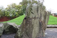
The Maiden Stone, Chapel of Garioch.

OS Grid Reference: NJ 70378 24714. About 1 mile to the northwest of the village called Chapel of Garioch, near Inverurie, Aberdeenshire, there is a very tall carved stone slab known as The Maiden Stone or The Drumdurno Stone, which has Pictish symbols on one side and a Christian cross on the other. This carved stone, standing beside a country road, is thought to date from the 8th or 9th century AD, and was probably carved at the time when the Picts of eastern Scotland were being Christianized. There are one or two Legends about a confrontation that took place here between a local maiden and the devil and, this seems to be where the name ‘Maiden Stone’ originates. As it is located near Drumdurno farm the stone gets its other name from that local place-name. Chapel of Garioch is 4 miles northwest of Inverurie and just off the A96. To reach the monument head to Chapel of Garioch village and, at the old post office, follow the minor road northwest for ½ a mile. The stone stands beside the road on the opposite side of the woodland, just before the entrance to Crowmallie House.

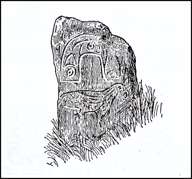
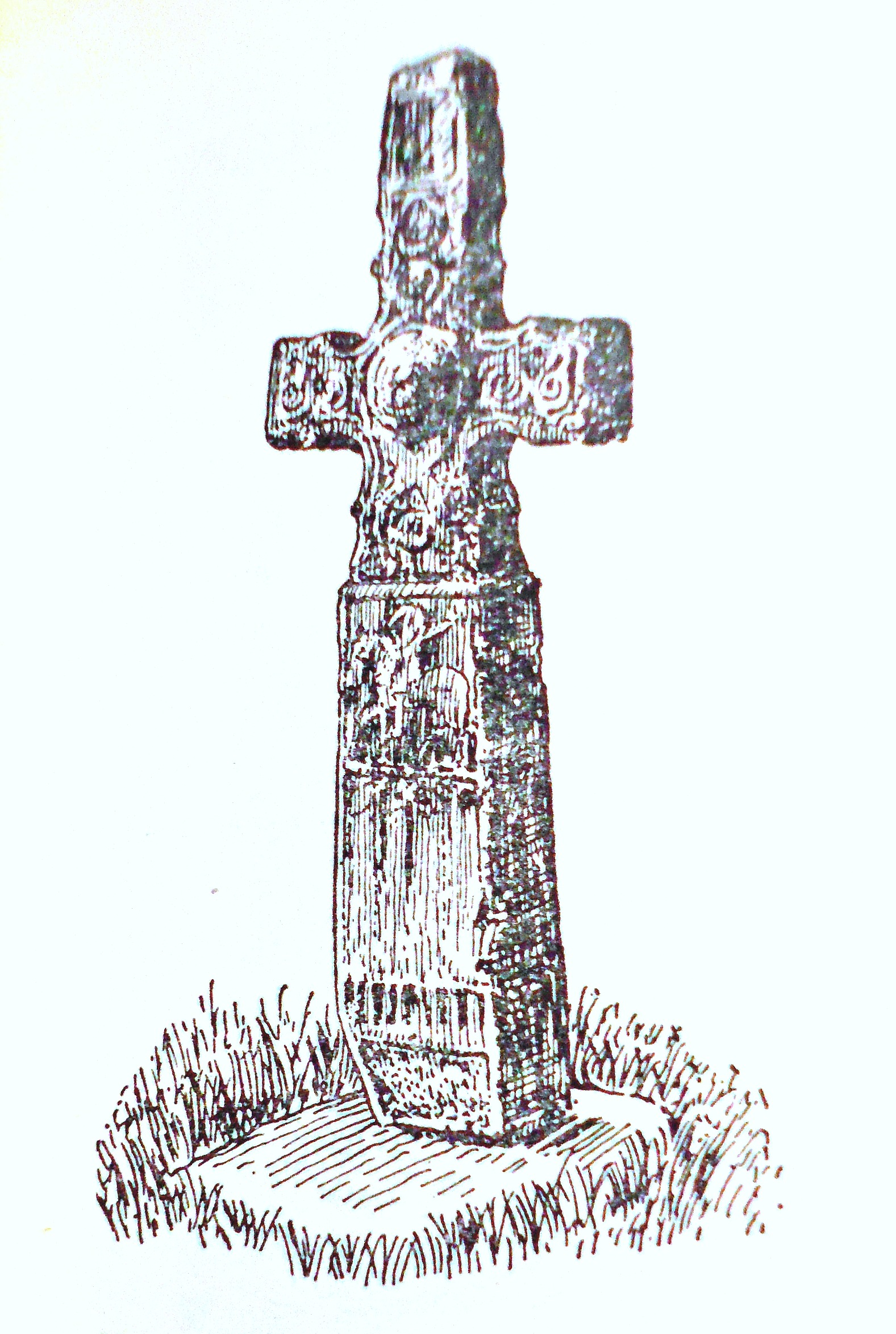
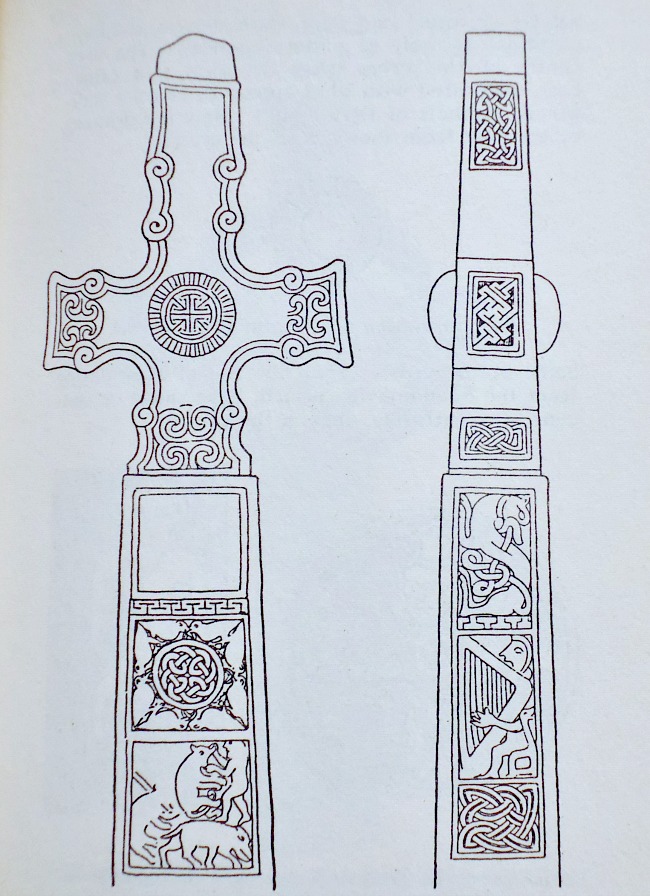
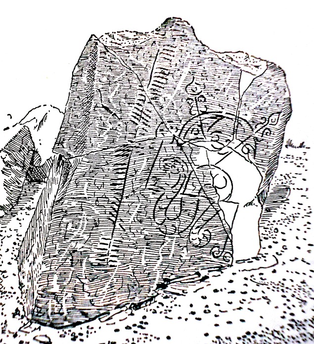
This tall Class II Pictish symbol stone and cross-slab is highly decorated although some of the carvings are now quite faint due to weathering. It is 10 foot high (3.2m) and is made of a pinkish-red granite. A triangular chunk or notch of stone is missing from the monument at one side about three-quarters of the way up and maybe some of the carvings too. The carving of a man with outstretched arms on the front of the stone may be a depiction of Christ; the carving of a ringed cross also on the front face would suggest that the Picts of eastern Scotland were Christianized at the time that this carving was made – perhaps in the early 8th century AD?

The Maiden Stone by Alexander inkson-Mccon-nochie (1890).

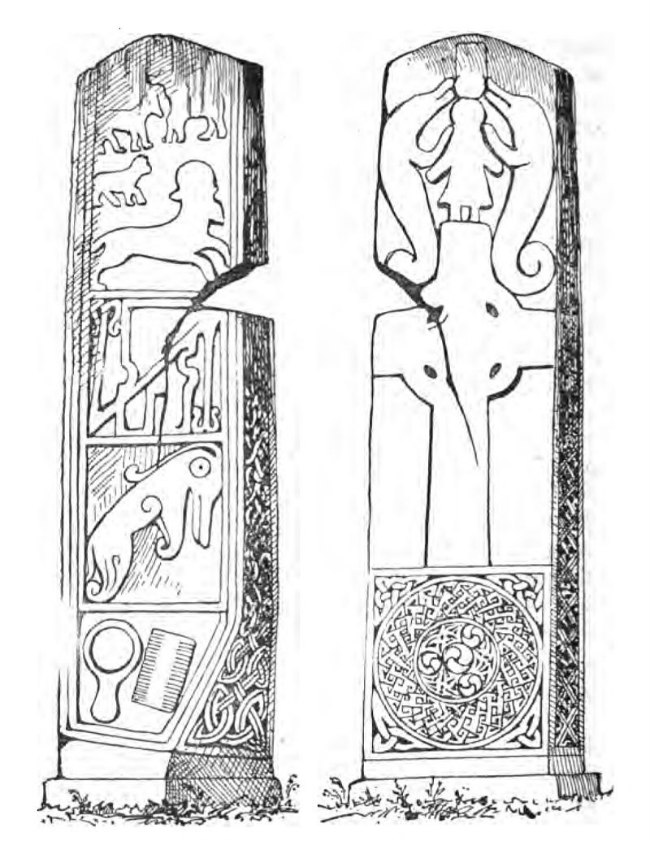
Elizabeth Sutherland (1997) gives her description of the stone and its carvings: “Front: divided into five panels: (1) above a cross find a man with arms outstretched and fish monsters with spiral tails on either side of him; (2) a ringed cross with round hollow armpits with all ornamentation defaced; in (3) and (4) no trace of sculpture remains; (5) spiral and knot-work decoration. Back: four panels reading from the top: (1) several defaced beasts; (2) a notched rectangle & Z-rod. A triangular section has been broken off the stone between these top two panels on the right following a natural crack in the granite; (3) a Pictish beast and (4) a mirror & double-edged comb. Both sides: decorated with very worn interlace. Comment: The Maiden Stone is one of the few Class II cross-slabs to be found in Aberdeenshire and may belong to the second half of the 9th century, thus post-dating the reign of Kenneth Mac Alpin. Political changes in the south may have had little immediate effect on the artistic traditions of the Picts here.”

Author Joyce Miller (2000) has a slightly different view of the stone carvings. She says that: “At the head of the front of the stone, a man stands with arms outstretched, holding a sea-monster in each hand. Below this group is a ringed cross, with traces of interlaced decoration at either side. At the foot of the cross there appears to have been a large and intricately patterned disc, with triangular knots filling out the external corners. The back of the stone is less weathered and shows several beasts of various descriptions in the top panel; below is a large notched rectangle and z-rod; below that is a fine Pictish beast; and at the bottom is a mirror and double-sided comb.”

The site entry for Maiden Stone (HMSO 1959), says this is: “The most famous of the Early Christian monuments in Aber-deenshire, this stone is associated with several weird legends formerly current in the Garioch. On one side it displays a richly ornamented Celtic cross and other decoration in the same style, and on the other side are Pictish symbols.”

Miller (2000) also tells of a story about the stone. She says that: “One story concerning the origin of the stone is that a daughter of the Lord of Balquhain made a bet with the devil that she could bake bread before he could build a road to the summit of the high hill of Bennachie. The devil won the bet, of course, and when the woman fled she was turned into the stone, either by the devil or to prevent her going to hell.”  Another story/legend tells that the maiden married a stranger who turned out to be the devil and that he finished the road and claimed the forfeit. The maiden ran from the devil and prayed to be saved. The legend finishes by saying that God turned her to stone, and the notch in the stone is where the devil grasped her shoulder as she tried to run away, according to Wikipedia.

Sources and related websites:

 H. M. S. O.,  Ancient Monuments – Scotland, (Volume VI),  H. M. Stationary Office, Edinburgh, 1959.

Jackson, Anthony, The Pictish Trail, The Orkney Press Ltd., St Ola, Kirkwall, Orkney, 1989.

Miller, Joyce, Myth and Magic – Scotland’s Ancient Beliefs & Sacred Places, Goblinshead, Musselburgh, Scotland, 2000.

Sutherland, Elizabeth, The Pictish Guide, Birlinn Limited, Edinburgh, Scotland, 1997.

https://en.wikipedia.org/wiki/Maiden_Stone

http://wasleys.org.uk/eleanor/presocialhistory/prehistory/stonesandcircles/pictish/maiden/index.html

https://canmore.org.uk/site/18978/chapel-of-garioch-the-maiden-stone

https://www.historicenvironment.scot/visit-a-place/places/maiden-stone/

© Ray Spencer, The Journal Of Antiquities, 2018. 


1 Comment

The Craw Stane, Rhynie, Aberdeenshire, Scotland

The Craw Stane at Rhynie, Aberdeenshire.

   OS Grid Reference: NJ 49718 26343. In a field just to the south of the village of Rhynie, Aber-deenshire, beside the earthworks of the ancient settlement overlooking the Water of Bogie, stands The Craw Stane or Crow Stone, a granite slab with Pictish symbols that are thought to have been carved in the 5th century AD. Several more Pictish stones have been found in this area including one called ‘Rhynie Man’, which now stands in the Council HQ in Aberdeen. The Craw Stane stands at the south-side of what is probably a prehistoric mound or cairn.  It can be reached along Manse Road, south out of Rhynie for ¼ of a mile. After St Luag’s church and cemetery follow the footpath heading to the southwest; the stone can be seen in front of you. Or it can be viewed from the side of the road by going south for 100m out of the village on the A97 (Main Street) and from nearly opposite the entrance to Mains of Rhynie.

   The Craw Stane or Crow Stone (also called Rhynie No 1) stands on the south-facing slope of the hill above the Bogie Valley and at the E side of the ancient earthworks of a Settlement and Enclosure (where there have been a number of archaeological finds) – at the W and SW sides of which are a couple of burial mounds from a much earlier date – the southwestern mound is quite large and could be a long cairn; at the southern edge of this the stone is to be found. It is a granite slab measuring 5 feet 7 inches high by 3 feet wide and stands on a stone base. This Class I symbol stone has two quite distinct symbols: a fish and a beast. The fish is probably a salmon while beneath that the beast might be any large animal, but the suggestion is that it is an elephant, but it is more likely to be a mythical creature. These carvings were probably done in the 5th or early 6th century AD, long before the Picts were Christianized.

   Several more Pictish stones can be found in and around the village of Rhynie. One known as Rhynie Man or Rhynie No 7 has a carving of an ogre with a big nose, sharp teeth, and a rather fragile axe; this now stands in the Regional Council HQ at Aber-deen. Another, The Barflat Stone or Rhynie Barflat No 8, is another Class I symbol stone that was ploughed up at Barflat farm in 1978 and had a beast, curvilinear symbol and comb, but is now also at Regional Council HQ, says Elizabeth Sutherland. Two stones that are damaged can be found at the entrance to the graveyard of Rhynie Old Church which is dedicated to St Luag (OS grid ref: NJ 4994 2650). Both were removed from the foundations of the original church when it was demolished in 1878, so says Elizabeth Sutherland. No 5 has a beast’s head, double disc and Z rod beside a mirror and single-edged comb, while No 6 has part of a double-disc and Z rod above a crescent and V-rod with a mirror below. Two more stones Nos 2 & 3 stand on Rhynie village green (OS grid ref: NJ 4980 2715) but are damaged. No 2 has carvings of a double-disc and V-rod, now invisible, while No 3 shows a man’s back, spear and disc, again according to Elizabeth Sutherland in her excellent work “The Pictish Guide’. There is also further information in ‘The Pictish Trail’ by Anthony Jackson.

Sources of Information and related websites:-

Jackson, Anthony, The Pictish Trail, The Orkney Press Ltd., St Ola, Kirkwall, Orkney, 1989.  

Sutherland, Elizabeth, The Pictish Guide, Birlinn Limited, Edinburgh, 1997.

The AA, Illustrated Road Book Of Scotland, The Automobile Association, London, 1963.

https://en.wikipedia.org/wiki/Rhynie,_Aberdeenshire

http://www.megalithic.co.uk/article.php?sid=12063

https://canmore.org.uk/site/17199/rhynie-craw-stane

http://portal.historicenvironment.scot/designation/SM69

                                                                                    © Ray Spencer, The Journal Of Antiquities, 2017.


Strathpeffer Pictish Stone, Easter Ross, Scotland

Strathpeffer Pictish Stone, Easter Ross, Scotland.

Strathpeffer Pictish Stone, Easter Ross, Scotland.

    OS grid reference: NH 4849 5850. At the edge of a field at the north-eastern side of the village of Strathpeffer, in Easter Ross, Scotland, stands a 7th century Pictish symbol stone known as ‘Clach an Tiompain’ or Tuideain (The Eagle Stone) – ‘Stone of the Turning’ or ‘The Sounding Stone’. The stone was ‘said’ to have marked a battle that took place in 1411 between two warring Scottish clans, and there was also a 17th century ‘prophetic’ legend associated with the stone. It is located at the edge of a field beside a line of trees at the north-eastern edge of the village – just off Nutwood Lane – and 85m south-east of Nutwood House – the stone lies 150m west of the A834 (Dingwall road). About 1 mile to the east along the A834 is St Clement’s kirk, Dingwall, and in the kirkyard a second Pictish stone.

    This Class I Pictish symbol is thought to date from the 7th century at which time the Pictish kingdom was ruled by the powerful King Bridei, son of Bili. It is made of contorted blue gneiss and is 2 ft 8′ high (81cm), according to Elizabeth Sutherland in her work ‘The Pictish Guide’. It is 24′ wide x 10′ thick. On its front (SE) face are carved two Pictish symbols: an eagle and above that an arched horse-shoe which has tiny circles with dots in them at the bottom of both arches and, another slightly larger circle with a tiny circle and dot inside that at the top – which are held by curved strands almost forming two more circles. There are no carvings on the reverse side. Sutherland says the eagle represents St John the Evangelist and means: justice and truth, while the arched horse-shoe signifies ‘a rainbow bridge between this and the other world’. The stone has suffered from slight damage at the top right side due to being moved about on a couple of occasions; it originally stood further down the hill in the direction of Dingwall, but was brought to its current position in 1411. It has also come to be referred to, in more recent times perhaps, as ‘the Marriage Stone’.

    The stone was traditionally said to stand on, or near, the site of an early 15th century battle between two Scottish clans: the Munros and MacDonalds – the clan Munro being victorias. Curiously the Munro clan symbol is the eagle! Local legend has it that the slain of the Munroe clan lie buried around the stone. The Mackenzie clan seemingly ‘also’ had some involvement here. And there was also a legendary ‘prophetic’ claim made by the 17th century Highland prophet Coinneach Odhar – better known as Brahan Seer (who was of the clan Mackenzie). He said that if the stone “fell” for a third time the Strathpeffer valley would flood right up to the stone (Sutherland, 1997). Linked to the Strathpeffer stone is the Dingwall Pictish Symbol Stone. This stands in the kirkyard at the left-side of the entrance path to St Clement’s kirk, but this is now badly weathered – Anthony Jackson ‘The Pictish Trail’. So were these two stones originally ‘a pair’?

Sources and related web sites:-

https://canmore.org.uk/site/12458/strathpeffer-clach-an-tiompain

http://www.megalithic.co.uk/article.php?sid=7191

https://en.wikipedia.org/wiki/Clach_an_Tiompain

http://www.historic-uk.com/HistoryUK/HistoryofScotland/The-Brahan-Seer-the-Scottish-Nostradamus/

Jackson, Anthony, The Pictish Trail – A travelers Guide To The Old Pictish Kingdoms, The Orkney Press Ltd., St Ola, Kirkwall, Orkney, 1989.

Sutherland, Elizabeth, The Pictish Guide, Birlinn Limited, Edinburgh, 1997.

The AA, Illustrated Road Book Of Scotland, The Automobile Association, London, 1963.


Dupplin Cross, Dunning, Perth And Kinross, Scotland

Duppling Cross (originally at Cross Park Field, Forteviot)

Duppling Cross (originally at Cross Park Field, Forteviot)

Os grid reference: NO 0190 1448. This very splendidly carved free-standing cross which is known as Dupplin Cross, has in recent years been re-housed inside the ancient church of St Serf at Dunning in the Strathearn region, Perth & Kinross, for safety’s sake as it originally stood on a hill at Cross Park Field near Bankhead Farm 1 mile to the north of Forteviot, Perth & Kinross (Os grid ref: NO 0505 1896). Forteviot was one of the Pictish ‘royal’ capitals and a palace is said to have been built there. The Dupplin cross is, infact, a Class III Pictish stone – the shaft displaying human figures and a Latin inscription – while the head of the cross has Celtic-style decoration. And also in the church there is a Pictish cross-slab and also a Viking (hogback) tombstone. The early 13th century church of St Serf (Servanus) is located in the centre of the village of Dunning some 3 miles south of Forteviot, 3 miles south-east of the A9, and 7 miles south-west of Perth.

Dupplin Cross (front & east side) by J. Romilly Allen.

Dupplin Cross (front & east side) by J. Romilly Allen.

The cross is made of local hard sandstone and is 8 foot 6 inches high and 3 foot wide across its arms, and it is said to date from about 900 AD, so quite late for a Pictish stone. It is a Class III Pictish cross, but it does not have any symbols as such, although there are numerous warrior-like figures and also Biblical characters as well as ornate decoration described as being ‘Celtic’ in style. On the front face of the cross roll moulding and little spirals at intervals on the arms – with a raised circular boss at the centre which, according to the very detailed work ‘Symbolism Of The Celtic Cross’ by Derek Bryce, is “decorated with what appear to be solar radiations, symbols of Divine light”; the boss itself having a tiny cross on it. The shaft (front side) has three panels, one of which is now known to have a Latin inscription recalling the Pictish King Custantin, son of Wuirgust (Constantine Mac Fergus), the other two depict birds with crossed and interlinking beaks and legs surrounding a raised boss of interlacing and, David (from The Old Testament) tending the lion’s paw, with two more animals at the side.

The opposite cross-face has roll moulding, but the decoration in the boss is damaged, and the arms have scrollwork and key-patterning at the top. Both edges of the cross have interesting carvings – that at the left side has three panels (top) and three more on the shaft (lower) with a beast biting its tail, a man probably David seated playing a large harp, and cord-plait work. The right edge (top) has four panels of interlacing and three more on the shaft (lower) with two dogs sitting on their haunches with paws touching, two warriors on foot with sheilds and spears, and knotwork. The opposite shaft face has three panels showing a warrior on horseback, four warriors on foot holding shields and spears, a hound leaping on another animal which is perhaps a hind, and key-patterning seperating it all, according to Elizabeth Sutherland’s very thorough work ‘The Pictish Guide’.

Also in St Serf’s church is a Pictish Class III sandstone cross-slab of the 10th century? This has a broad-type Wheel or ring cross in high relief which is 3 foot 10 inches high. This slab was dug up from beneath the floor under the church tower about 1900. The cross at the top is, rather oddly, repeated lower down the slab but only about half of it has been carved; the sides of the slab have typical Celtic interlacing, now rather worn. And a tombstone of the 10th or 11th century is thought to be a Viking hogback. This has a cross carved upon its front-side and cable moulding at its border.

St Serf or Servanus, patron of Dunning Church, founded a monastic school at Culross, Fife, in the early 6th century. Traditionally, he baptised and tutored St Kentigern (Mungo); and is perhaps wrongly acredited with the title: Apostle of Fife. He died in 560 or 580 and his feast-day is usually held on 1st July.

Sources:

Bryce, Derek., Symbolism Of The Celtic Cross, Llanerch Enterprises, Felinfach, Lampeter, Wales, 1989.

Jackson, Anthony., The Pictish Trail,  The Orkney Press Ltd., St Ola, Kirkwall, Orkney, 1989. 

Sutherland, Elizabeth., The Pictish Guide,   Birlinn Limited, Edinburgh, Scotland, 1997.


Brandsbutt Stone, Inverurie, Aberdeenshire, Scotland

Brandsbutt Stone near Inverurie.

Brandsbutt Stone near Inverurie.

Os grid reference: NJ 7599 2240. At the north-side of Inverurie town and at the corner of Brankie Road and Garden Terrace stands the Brandsbutt Stone, a Pictish symbol stone that has been lovingly restored. This large rock has a number of ancient symbols and an Ogham inscription on it. Strangely enough it now stands next to a modern housing development, but two large pieces of it were retrieved from a ditch near Brandsbutt farm, while another piece was found in a wall close by. The stone is sign-posted from the A96. Chapel of Garioch, where stands the famous Maiden Stone another Pictish stone, is 4 miles to the north-west on the A96, while the city of Aberdeen is 13 miles south-east in the opposite direction, also on the A96 road. There are several more Pictish stones in Aberdeenshire.


Brandsbutt Stone at Inverurie, Scotland. (Photo credit: Wikipedia)

Brandsbutt Stone at Inverurie, Scotland. (Photo credit: Wikipedia)

The Brandsbutt stone is a class 1 Pictish symbol stone that is 3 foot 6 inches high and over 4 foot wide. It has some interesting carvings on it: a crescent, V-rod, Z-rod and a twisting serpent. There is also an Ogham inscription, a series of notches, recalling IRATADDOARENS which could be simplified as ‘Iratad Doarens….’ with a few notches possibly missing at the end which could be IUS or SIUS? Ogham was the ancient Irish alphabet script widely used in the Celtic west during the 5th-6th centuries, but also used in Scotland at a slightly later date due to the close ties between the two countries. The rock is made of whinestone, much quarried in Scotland, especially in the south.

Thanks to a local man the Brandsbutt Stone has been lovingly restored to what it originally looked like. Two lumps of the stone were rescued in 1899 from a field-dyke dividing two fields and another piece from a wall, a little to the east of Brandsbutt farm, which has now been demolished to make way for the new housing estate (Elizabeth Sutherland ‘The Pictish Guide’). Thankfully, the stone was recognised as being of great historic importance and part of the Pictish kingdom of Scotland which “flourished” during the 8th-9th centuries, but which actually began ‘its life’ as early as the 4th century AD, according to Anthony Jackson in his delightful little book ‘The Pictish Trail’ 1989.

Sources:

Photo Wikipedia: http://en.wikipedia.org/wiki/Brandsbutt_Stone

Jackson, Anthony., The Pictish Trail, The Orkney Press Ltd., St Ola, Kirkwall, Orkney, 1989.

Sutherland, Elizabeth., The Pictish Guide, Birlinn Limited, Edinburgh, Scotland, 1997.


Sueno’s Stone, Forres, Moray, Scotland

OS grid reference NJ 0465 5953. At the east side of the village of Forres, before reaching the B9011 road, turn left into Findhorn road and, on the opposite side of the road in a field, stands the famous Sueno’s Stone, a very tall class III Pictish stone/cross-slab, which since the 1990s has rather unfortunately been housed within a horrid glass, protective cage – although it is now stopping any further erosion to the beautiful Pictish carvings, so that has to be a good thing. It used to stand inside iron railings. The stone is said to weigh over 7 tonnes. According to authoress, Elizabeth Sutherland, in her delightful book The Pictish Guide, 1997, of the stone she says: “It is undoubtedly one of the finest examples of Dark Age sculpture in Europe and should not be missed”. The town of Nairn is 10 miles to the west on the A96 and the town of Elgin is 11 miles to the east also on the A96.

Sueno’s Stone (Swein’s Stone) is a ‘highly sculptured’ Old Red Sandstone pillar standing on a low, stepped base at between 21-23 feet high (6-7 meters) that is thought to commemorate a battle or battles that took place in the mid 9th century AD, according to the legend. Many of the decorative scenes depict Dark Age battles which took place in Scotland, but there are is also a strong Christian theme running through much of the ornamentation, and very beautiful it all is too. There are, however, no Pictish symbols on class III stones. The general thinking is that the battle scenes depict King Kenneth MacAlpin and his victories over the Picts circa AD 842, or could they in fact be earlier in date or, indeed, slightly more recent? We don’t even know for certain who “Sueno” was. The authors Janet & Colin Bord in their book Ancient Mysteries of Britain, 1991, suggest that “Sueno for whom it is named may have been a Norse king defeated near this spot by the Picts”. It seems ‘quite’ likely that the stone was moved to it’s current position from somewhere nearby having apparently lain buried in the ground for some considerable time; the very first reference to this stone came in the early 18th century.

English: Sueno's Stone. This is a historic sho...

Sueno’s Stone by Anne Burgess(Geograph).

On the front side of the pillar there are 11 panels with ‘many’ horsemen riding into battle and numerous human characters, probably Pictish warriors, but also characters not involved in any battle but, which could possibly recall the coronation of Kenneth MacAlpin, in particular the two tall figures bending over a seated figure – now echoed by a few leading experts in the field. The best part is quite obviously the very large wheel-headed cross with it’s long shaft on a rectangular base in the centre of this face; this being the part that seems to draw our full attention and, was probably meant to do just that because it takes up most of the face; there is also the more familiar knotwork interlacing both on the shaft and on the sides.

The opposite side (back) is quite literally covered in upto 100 figures, elite warriors and horsemen all in 4 panels. The general concensus by historians on Pictish history with regard to this side of the stone is that the carvings say out loudly: ‘the Pictish kingdom is finished and the Scots are “victorious” and here to stay – make no mistake about that’. King Kenneth MacAlpin is now in charge. In panel 1 there is a row of figures holding swords and standing above eight warriors on horseback (in three rows facing left); another row of warriors in panel 2 – the middle figure wearing a kilt could be King Kenneth MacAlpin? Another row has eight figures with the two in the centre, fighting and, a third row has six severed heads with a bell and next to that six corpses without their heads, while a warrior is about to behead a seventh figure; beneath that two couples are fighting with their hands. The fourth row has more mounted warriors fighting (in three columns) and making their escape from warriors on foot.

In the third panel there are yet more warriors in pairs and, in the centre what is perhaps a bridge, tent or a broch with corpses and severed heads beneath it, while below that two pairs of figures orating the battle scene. Panel 4 shows two rows of warriors facing left with the four front figures unharmed and chained and their victors with sheilds and swords following them. The edge of the stone (right) is carved with leaves and plants and the heads of beasts linked and intertwining, while below that two human heads; the left edge shows more beasts, interlacing and men with fish tails interlaced to form figures of eight; three more heads can be seen beneath this. It is thought the stone was actually set up by the victorious Kenneth MacAlpin who had now become king of the Scots – thus ending the rule of the Picts in Scotland. The Picts now had to accept the ‘inevitable outcome’. MacAlpin died in AD 858 or 859 – having ruled as king of the Picts and, later of the Scots from circa 834 AD. He died at Forteviot in Perthshire and was buried on the Isle of Iona.

Sources:

Sutherland, Elizabeth., The Pictish Guide, Birrlin Limited, Edinburgh, 1997.

Bord, Janet & Colin., Ancient Mysteries of Britain, Diamond Books (Harper Collins Publishers Ltd), 1991.

Jackson, Anthony., The Pictish Trail, The Orkney Press Ltd., St Ola, Kirkwall, Orkney, 1989.

https://en.wikipedia.org/wiki/Sueno%27s_Stone

http://www.britroyals.com/scots.asp?id=kenneth1

http://www.ancient-scotland.co.uk/site.php?a=141