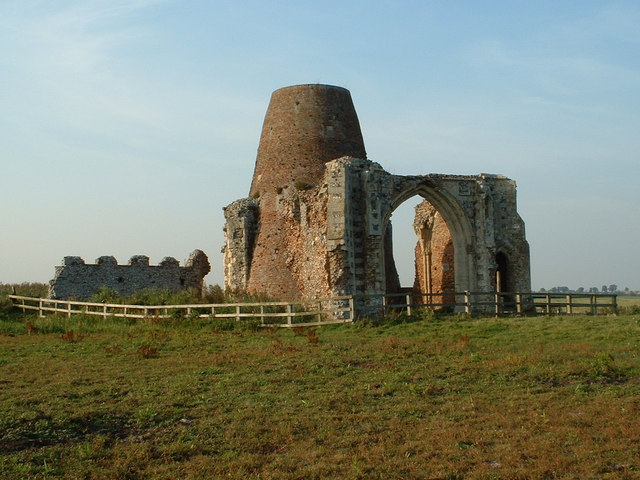
OS grid reference TG 3832 1564. On a slightly raised area of land just a little north of the River Bure at Holme, Norfolk, lie the quite solitary remains of St Benet’s Abbey – with it’s church and gatehouse. A little to the north there are some more earthworks and fish ponds from what was once a large, thriving religious foundation. To the north-west of the ruins an old windmill now, alas, without its roof and sails looks forlorn but is, in fact, a more recent building built on the abbey’s lands which are said to have once covered up to 35 acres, and around which the ruins of the abbey’s gatehouse, built in the 14th century, still stands (on private land), although in a somewhat ruinous state, but under preservation. The abbey was originally built on what was an island called Cow Holm, surrounded by marshy land and the rivers Bure and Ant which meet each other at this point.
According to documented evidence the site was first inhabited back in the early 9th century by an Anglo-Saxon, Benedictine monastery, then later the Vikings invaded the area and destroyed the abbey, but in the early 11th century a larger, more influential Benedictine abbey was established on the site. The ruins are difficult to reach from the A1062 near Ludlam half a mile north via trackways and paths, but rather easier to reach by boat on the nearby River Bure, in what is a nice part of the Norfolk Broads. The city of Norwich lies roughly 7 miles south-west on the A1151, while Great Yarmouth is 10 miles to the south-east along the A149 on the Norfolk coast.
About 800 AD a hermitage and chapel existed here with Suneman as the founder but he was murdered by Viking invaders; then a small Anglo-Saxon monastery for Benedictine monks was established here but not a great deal is known about it and it did not last long because Viking invaders pillaged and destroyed the building in 870 AD – it’s unclear as to what happened to the monks, if they survived at all? The place lay abandoned and ruined until about 960 or perhaps 980 when the abbey was partly rebuilt by Wulfric the hermit and, by 1019-20 King Cnut granted the abbey and it’s ‘lands’ to the Benedictine order once again, and they then extended, enlarged and fortified the building under the first abbot, Elfsige, making it into a thriving and quite wealthy religious centre of learning. King Cnut ruled from 1016 to 1035.
During the Middle-Ages the abbey of St Benet’s (named after St Benedict, founder of the order) prospered and eventually owned upto 35 acres of land here, and eleswhere; some accounts put this at 80 acres. The monks founded two hospices for the sick at Horning, Norfolk, and another for the poor at Great Hautbois, Norfolk; and there were also dependancies at Bury St Edmunds, Suffolk, and Rumburgh, Suffolk; they also had charge of many local churches. The monks farmed the land around their abbey and kept fish ponds – they were probably very self sufficent. By 1539 only a handful of monks were allowed to remain at St Benet’s and in 1545 it was finally abandoned and the remaining monks expelled by bishop Rugge of Norwich who had been given their land by King Henry – much of the stone being robbed away and used in the local area, or further afield in Norwich; only the gatehouse has survived and scant walls of the church, dating from 1270. The abbey did, however, survive the Dissolution of the Monasteries and for this reason the current Bishop of Norwich can still call himself ‘abbot of St Benet’s Holme’.
Today some of the abbey walls still stand but are only a shadow of what height they would originally have been. At the east end the stone altar supports a wooden cross of recent date. Around the site, just to the north, there are numerous other foundations of the conventual buildings, precinct wall, earthworks and even the monks fishponds. The abbey gatehouse, to the north-west, is in a ruined state but is under preservation. The conical-shaped windmill dates from about 1760-80 but no longer has its roof or sails; it was later used as a drainage mill and wind-pump. A causeway across the marshes was built by the monks and is still just visible to the west and there are traces of boundary ditches and banks, marking the extent of the abbey’s lands much further to the west close to Horning (St Benedict’s) church. Choir stalls from the abbey can be seen in nearby St Helen’s church, Ranworth.
.
Sources:
https://en.wikipedia.org/wiki/St_Benet%27s_Abbey
Bottomley, Frank., The Abbey Explorer’s Guide, Kaye & Ward, London, 1981.
Butler, Lionel & Wilson-Chris Given., Medieval Monasteries of Great Britain, Michael Joseph Ltd., London, 1979.
Pastscape: http://www.pastscape.org/hob.aspx?hob_id=133454#aRt
Norfolk Archaeological Trust: http://www.norfarchtrust.org.uk/stbenets


