The Journal Of Antiquities

Ancient Sites In Great Britain & Southern Ireland


The Long Stoop, Yeadon, West Yorkshire

Photo credit, see below.

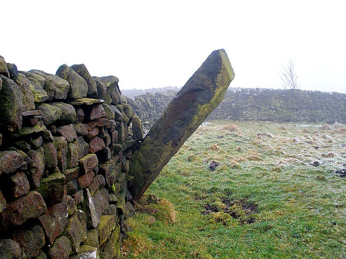
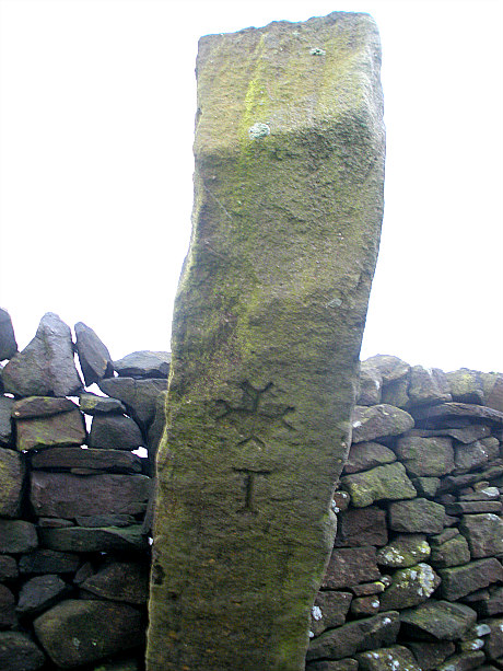
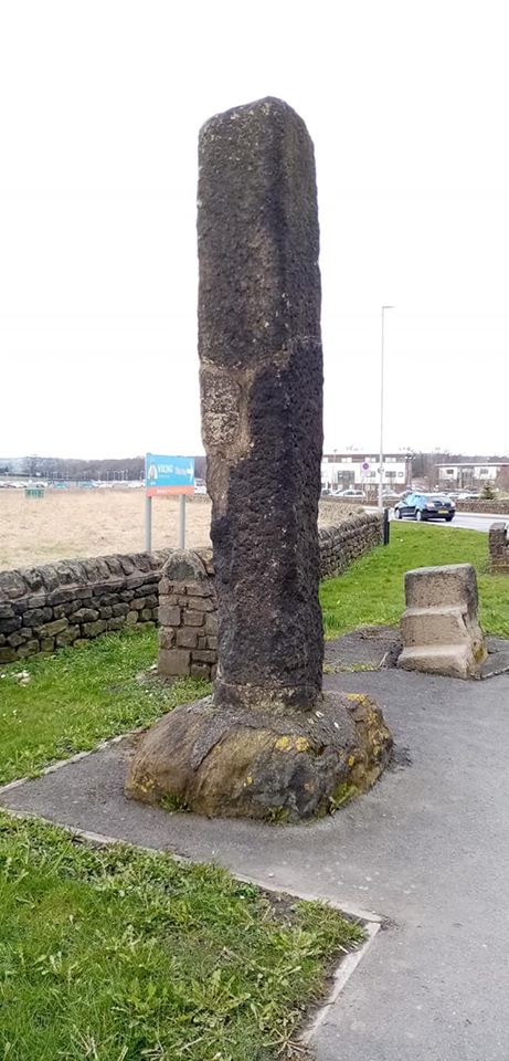
NGR: SE 22127 41831. At the side of the roundabout on the very edge of the Leeds-Bradford Airport at Yeadon, west Yorkshire, stands a rather curious gritstone pillar that looks rather out-of-place being located where it is, but it has, in fact, been moved in order to facilitate its predicament of being in the way of an airport runway extension; the most recent move being in the early 1980s.  This tall, roughly-hewn stoop stone is actually a boundary stone or guide stone whose base is all that remains of the original stoop from the early part of the 19th Century, which had, at that time, stood at Coney Lodge Farm about a ¼ of a mile to the northeast, but was apparently destroyed by lightning. The ‘Long Stoop’ Stone stands beside what looks to be a mounting block! on the verge of the A658 roundabout at the junction of Victoria Avenue (Harrogate Road) and Warren House Lane at the northwestern perifery of the Leeds & Bradford Airport complex, just to the east of Yeadon.

The original ‘Long Stoop’ Stone which had stood for a few hundred years at Coney Lodge Farm, near Yeadon, was destroyed by lightning around 1836 after which a replacement stoop was erected a ¼ of a mile to the west on the Harrogate Road turnpike     at Crown Point (east side of Yeadon), but in 1983 it was moved once again a short distance to the side of the A658 roundabout when an extension to the airport’s runway was being built. It is a boundary or guide stone and is a tallish, rough-hewn gritstone pillar with a flat top, and is set into a base stone from the original old stoop; but it has been blackened by the chimney smoke from nearby Bradford and Leeds which occurred during the Industrial Revolution. Today, however, it is probably something of an oddity or curiosity to the people in their cars going round the roundabout. See the very excellent ‘Aireborough Historical Society’s’ website, below, for further historical information and old photos.

Sources / References & Related Websites:

Photo by Patrick John Leonard. Thanks mate.

https://www.aireboroughhistoricalsociety.co.uk/yeadon/long-stoop-1900.aspx

https://www.aireboroughhistoricalsociety.co.uk/yeadon/long-stoop-1979.aspx

http://www.leodis.net/display.aspx?resourceIdentifier=20041019_84974307

https://www.geocaching.com/geocache/GC6C6DJ_yeadon-stoop?guid=228e1a7c-5db9-47c4-8ed8-0113448d5e09

https://en.wikipedia.org/wiki/Yeadon,_West_Yorkshire

© Ray Spencer, The Journal of Antiquities, 2020.


Watersheddles Cross, Near Scar Top, Lancashire-Yorkshire Border

Watersheddles Cross, near Scar Top, on the Lancs-Yorks border.

   OS Grid Reference: SD 97121 38282. On the southern flank of Kiln Hill and overlooking the northern end of Watersheddles Reservoir, near Scar Top, is the Medieval boundary stone called Watersheddles Cross or Hanging Stone which, even today, marks the boundary between Lancashire and Yorkshire. The old stone now leans over at a considerable angle but is still recognizable for what its original purpose was; and maybe it was an ancient standing stone from prehistory. It has a rather crude inscription on one side with the name in large letters. It is, though, uncertain why it also has the name ‘Hanging Stone’ and what that means with regard to the stone. The cross can be reached from the little boundary stone on Two Laws Road – just after the reservoir and going towards Scar Top. Follow the wall up the moor on an undefined path to a metal gate, then continue up beside the wall until that stops and veers off in the opposite direction. You will see the Watersheddles Cross more or less in front of you.

Watersheddles Cross (with recent carving)

Watersheddles Cross on Lancs-Yorks boundary

   The Watersheddles Cross or Hanging Stone is a rough-hewn length of stone some 6 feet long that leans at a 45° angle or maybe more and is held in position against another lump of stone, with yet more lumps of stone at its base and surrounding it. It used to stand upright. Maybe long ago in the mists of time there was a wooden cross here, but this rotted away and had to be replaced by a stone one. This rough pillar of stone may have originated from somewhere else on the moor, and perhaps it had been a standing stone from prehistory, though whether it was we don’t know with any certainty. However, the stone was apparently brought to its present location in the 14th century and, sometime after that, probably after 1618, the large lettering on its west side carved onto it. The nice little cross at the top of the stone has obviously been carved more recently, maybe the 19th century, and the top part of the stone cut-away to allow for this. So “why” is it also called ‘Hanging Stone’ – that we don’t know, but there are many other rocks and stones that have this name. There are other boundary stones further up the moor to the north towards Wolf Stones, an outcrop of gritstone rocks which are visible from here.

Sources and related websites:-

Water Sheddles Cross, Oakworth Moor, West Yorkshire

https://historicengland.org.uk/listing/the-list/list-entry/1009495

http://www.bradfordhistorical.org.uk/boundary.html

http://www.pastscape.org.uk/hob.aspx?hob_id=46131

                                                   © Ray Spencer, The Journal Of Antiquities, 2017.


The Pole Stoop Stone, Green Sykes, Cowling, West Yorkshire

The Pole Stoop Stone, near Cowling, west Yorkshire.

The Pole Stoop Stone, near Cowling, west Yorkshire.

    OS Grid Reference: SE 0153 4169. Halfway between Cowling and Keighley, west Yorkshire, is the boundary stone known as ‘The Pole Stoop’. It is an interesting stone in that it has a decorative, florated cross carved onto it, which is different to many other similar stones that tend to have just Latin letters on them, although this stone does have a Latin letter carved onto it. The Pole Stoop juts out of a field wall close to Pole Road, between High Pole Farm and Green Syke Farm. A footpath goes through the wall at the side of the lane, then to the right, and at the drystone wall you have the leaning stoop stone, located on what was the old bound-ary of Lancashire and west Yorkshire, some 4 miles east of Cowling and 2 miles south-west of Sutton-in-Craven.

The Pole Stoop Stone (close-up of the carvings)

The Pole Stoop Stone (close-up of the carvings)

    The Pole Stoop Stone is a 7 foot-long slender block of gritstone that leans out from the wall at a precarious 45 degree angle, but originally it was a free-standing stone and probably up-right – the wall being built up to it in the last 100 years or so. Or was the stone meant to lean (stoop) and point in the direction that it does? We do not know when the stone was erected here – some think it was the 15th century, others think it was the 17th century. In the middle of the west face there is carved a very nice florated cross and just below that a letter “T” is carved. This Latin-style letter and the cross were probably carved by the person who set up the stone,  or maybe by the landowner wanting everyone to know that “here” lies the county boundary. But the stone would obviously be useful as a ‘waymarker’ stone to travellers traversing the moor, but being different to a milestone in that it had no hands pointing to the nearest village and no mileage numbers.

    There are other odd looking stones in the vicinity, and ¼ of a mile to the north, beside a farm gate along Green Sykes road, is ‘The Sutton Stoop’, a 4½ foot-high stone pillar with a cross and the place-name “SUTTON” carved onto it.

Sources:

http://www.bradfordhistorical.org.uk/boundary.html

http://northernantiquarian.forumotion.net/t280-pole-stoop-standing-stone-or-hanging-stone