The Journal Of Antiquities

Ancient Sites In Great Britain & Southern Ireland


The Carved Stone Heads of Ribchester in Lancashire.

NGR: SD 64977 35007. It is of interest that there seem to be a number of carved stone heads in and around the village of Ribchester in the Ribble Valley, Lancashire. A few of these carved heads may be Medieval in date, while others are probably more recent, but, it is unlikely any of them are actually “Celtic stone heads”, which has sometimes been assumed to be the case by a few local historians. There are two stone heads in the porch of St Wilfrid’s parish church that look to have some great age to them, while the others are located at various halls and farmhouses in and around the village; and another head can be found at Longridge, a few miles away. These stone heads do not, however, date from the Roman period for as we know Ribchester is well-known for its Roman fort of Bremetennacum and also its museum of Roman and prehistoric antiquities, but, it is possible one or two could be Romano-British and, therefore, depict deities from that particular time, which can then be referred to as “Celtic” in origin.

Thornley-with-Wheatley.

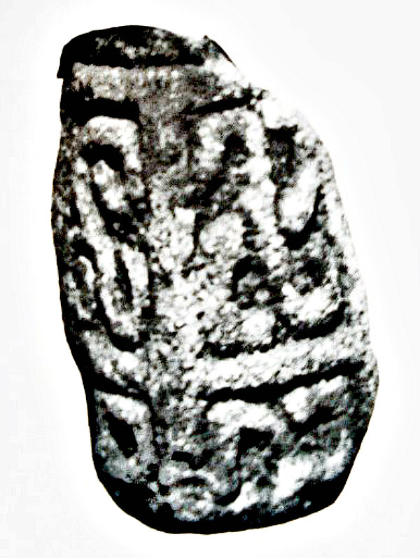
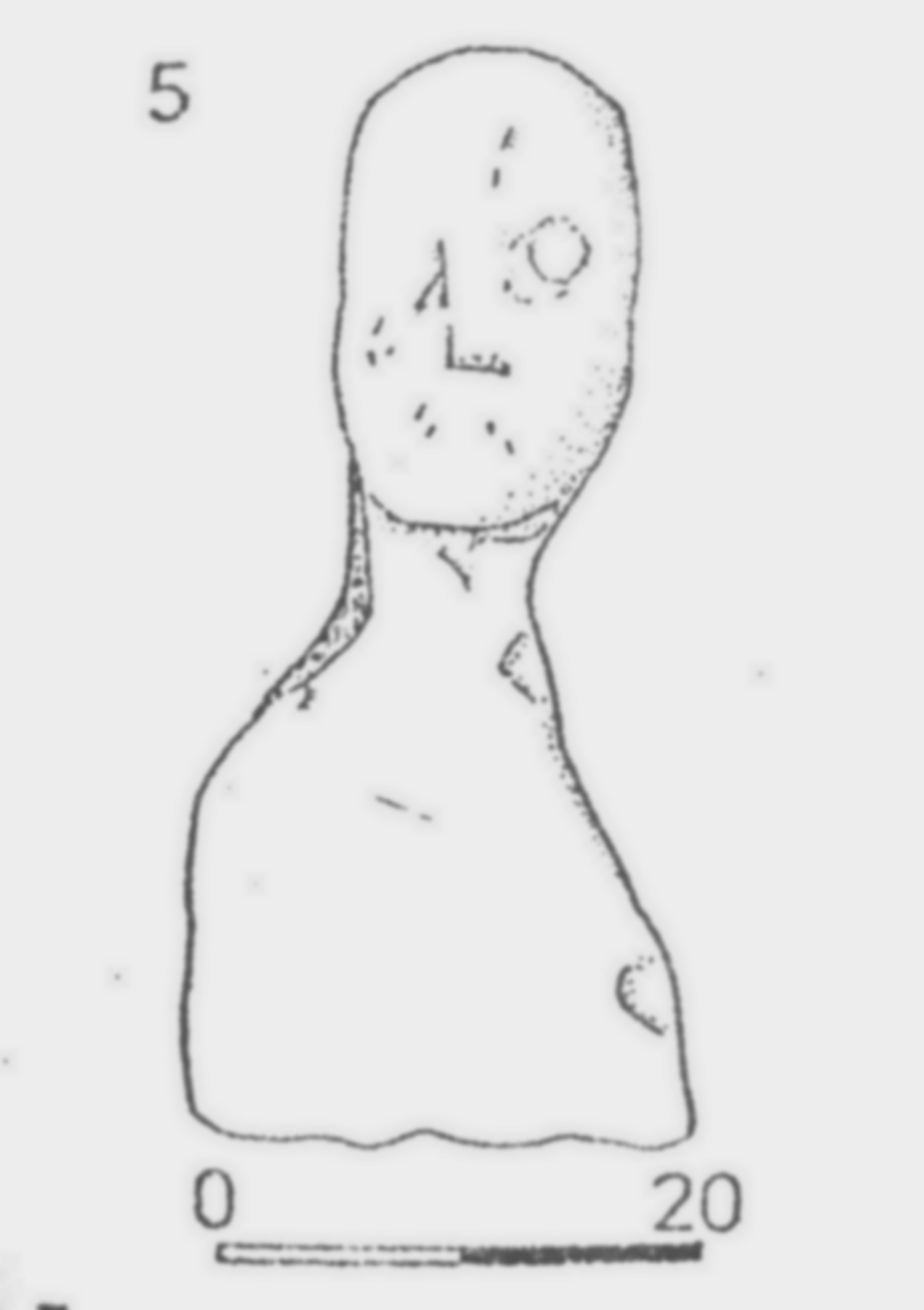
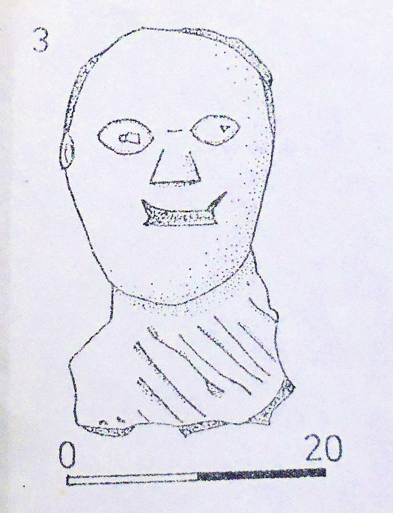
Stone head from Hades Farm near Ribchester, Lancs.

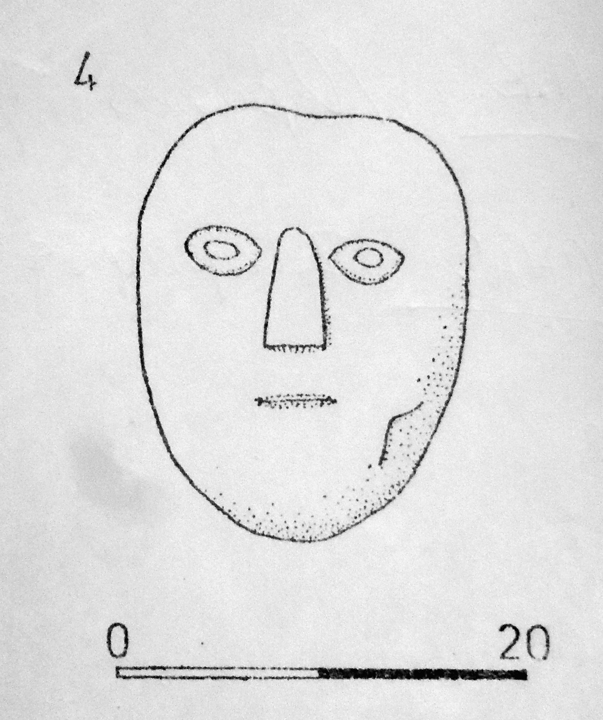
Margaret Edwards writing in ‘Lancashire Archaeological Bulletin’, 1987, in the article called ‘The Stone Heads of Ribchester’ gives the following information, which I have sourced. There is a stone head at Hades Farm, Ribchester, at (NGR SD 627364) built into the Farmyard wall there. This head is made of Sandstone and is 33×17 cms. The head has similar examples in Yorkshire at Chapel Allerton (Leeds). A second Sandstone head in the farmyard wall at Hades Farm measures 21×15.5 cms. This head has similar parallels at Arma-ghbragne (Co. Antrim) and Correvilla (Co. Cavan) in Ireland. There is a stone head in a field wall at Thornley-with-Wheatley, near Ribchester. This Sand-stone head measures 38.5×18.5 cms. It is very worn and is known to have been associated with two others but, due to frequent wall demolitions, is now solitary. Two similar heads to this are at Chapel Allerton (Leeds). Photo (right) is the carved stone head from Thornley-with-Wheatley, near Ribchester, Lancashire.

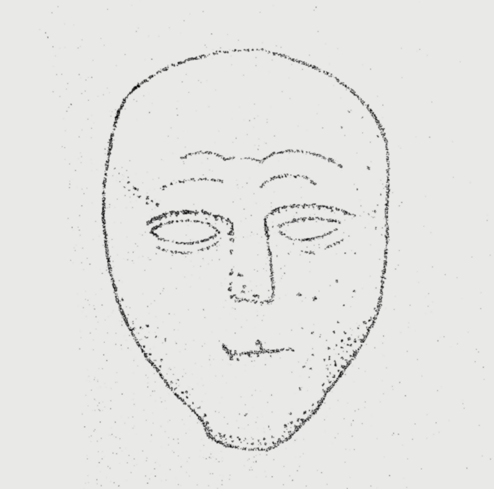
The carved stone head at Longridge Library, Lancashire.

In the Gable wall of Ivy Cottage in the village of Dilworth, near Ribchester (NGR: SD 623375) is another stone head made of Sandstone, which measures 30 cms high. This head is white-washed and inscribed with the date 1856 from when it was built into an adjacent building. A good example of this head was found at Corraghy in Ireland. And another head also in the Gable wall of Ivy Cottage was previously built into the adjacent building. This head is also whitewashed, but this example looks to be Medieval, rather than Celtic. This head has a similar parallel to (Jackson’s) carved head at Bradford. One other carved stone head, with little information, was found in the Ribble Valley, but is now residing in the British Museum. There is, however, a copy in Ribchester Museum. This was a Sandstone head and measured 30×23 cms. It was found between 1870-1880 and may have been found close to the River Ribble in the vicinity of the De Tabley Arms. One interesting stone head can be seen in the early 1960s wall behind Longridge Library (NGR: SD 606373) and was previously built into an earlier 18th-century wall which was demolished to clear the area for the building of the library. It is a Sandstone head and measures 16.5×12 cms. The Longridge stone head is similar to one found at Wardle, near Rochdale, although the exception being that it has ‘hair’! The Wardle stone heads, there are two of them, are on display at the entrance to Touchstones Museum, Rochdale. A similar head to that of Longridge was (Jackson’s) stone head from Keighley, west Yorkshire.

Stone Head at Hades Farm.

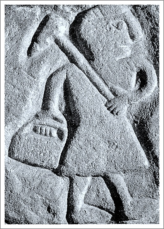
John Dixon in his 1993 work ‘Journeys Through Brigantia — The Ribble Valley’ mentions two stone heads in the porch of St Wilfrid’s parish church, Ribchester, Lancashire. He also says regarding Hothersall Hall near Ribchester (NGR SD 63193475) that: “In the fork of a tree on the lane above the hall can be found an horrific and grotesque stone head. This was dug up by a farmer at Hoth-ersall and placed in its present position.” John goes on to discuss the stone heads at Hades Farm. He tells us that: “Set into the gable of the porch at Hades Farm are two fine ‘Celtic’ heads. The owners have no knowledge of their origin, other than that they were once set into a low wall opposite the house. The lower  head is more typically Celtic than the one above, having the wedge-shaped nose and oval eyes.”, says John.

Sources / References & Related Websites:-

Dixon, John & Phillip, Journeys Through Brigantia — The Ribble Valley, Volume Nine, Aussteiger Publications, Barnoldswick, 1993.

Edwards, Margaret, Lancashire Archaeological Bulletin, Vol. 10, No. 4, February 1987.

https://watts.uk.net/hothersallhall.org/history.htm

More info here:  https://brigantesnation.com/celtic-heads

https://artuk.org/discover/curations/take-five-celtic-heads

Copyright © Ray Spencer, The Journal of Antiquities, 2023.


4 Comments

The Triskele Stone, St Michael’s Church, Iselgate, Cumbria

The Triskele Stone from photo at St. Michael’s church.

NGR: NY 16240 33314. The Church of St Michael at Iselgate, half a mile southeast of Isel village, in the Derwent Valley, Cumbria, used to house the famous ‘Triskele Stone’, a Celtic symbol of motion, but sadly it was stolen from this 12th Century Norman church in 1986. Only a photo survives. However, there are still two large fragments of an Anglo-Saxon cross-shaft. The Triskele is a pre-Christian symbol or motif consisting of a three-armed carving similar to the Manx symbol (Three Legs of Man) which might represent the Holy Trinity? although the symbol goes back thousands of years to the Neolithic, and was used in ancient Greece; this particular stone, however, had Viking origins, being associated with the Norse gods, Thor and Odin. The stone also had carvings of a sun-snake and a four-armed swastika (or fylfot – the symbol of Freya). The hamlet of Iselgate is a few miles northeast of Cockermouth, whilst St Michael & All Angels’ Church is just off Blindcrake Lane – beside the river Derwent, not far from Isel Hall.

Stanley Kingsnorth (1984) in a magazine article tells us a lot about the Triskele Stone, saying: “The Triskele Stone came to light in 1812 when the bridge of 1691 spanning the river Derwent was rebuilt.” Mr Kingsnorth continues, saying it: “takes its name from the three-limbed design which appears on two faces, a variation of this sign is well known to us as the three-legs of Man. This strangely sculptured stone, now placed in front of one of the chancel windows, is about twelve inches high and has been closely studied by scholars. It is described in some detail by the Rev. W. S. Calverley, a former vicar of Aspatria in his paper presented to the Cumberland and Westmorland Antiquarian and Archeology Society in 1885. 

“Each of the four faces of the stone shows designs in relief, those in the upper panels being different on each side, while the lower panel of all sides displays the “‘Sun-Snake”′ sign resembling a double ended hook on its side, which is to be found in the relics of many early cultures. Three of the upper panels depict the emblems of the principal pagan Norse gods. The symbol for Thor is the thunderbolt or hammer device and appears in strong relief on one face. Another side is adorned with an unsymmetrical triskele sign with two limbs to the left and one to the right and which is attributed to Odin, or in the alternative spelling, Woden. 

“On the third face a four-armed swastika appears, being the symbol of Freya the god of fertility and peace, while the re-maining side shows a balanced triskele having all three arms turning to the right, that is, with the sun. This sign is held to represent the Trinity of the Christian faith, and is the most significant dedication if the stone is, as so many suppose, part   of an early stone cross which stood on the site..”  

Stanley Kingsnorth goes on to add: “The other two stones now to be found near the south door are clearly fragments of the main shaft of a pre-Norman cross probably of a later date than the Triskele Stone. They were discovered in the walls of the church during the major restoration which took place just over 100 years ago. One is worked in relief on two sides and the other on all four faces with a variety of spirals and whorls, typical Christian designs of the Celtic post-Roman period. But again the pagan influence has persisted, as at the bottom of the fully patterned stone there is a boldly carved broad arrow or spearhead pointing downward. In his study of 1889, Calverley identified this as the sacred emblem of Woden as descri-bed in the old Norse sagas, where the unfortunate sacrifice has his breast marked with the point of a spear and is offered to Woden, after which he is hanged.

“In heathen ritual, the gallows was in the form of a cross, usually of ash, so it can easily be understood how the Cross of Christ and the symbolic ash cross of the Nordic peoples came to have an over-lapping meaning to the diverse inhabitants of this remote area during the confused and changing times between the withdrawal of the Roman legions and the arrival of the Normans. 

Lawrence E. Jones & Roy Tricker (1992)  say that Isel church has: “A perfect setting by the river Derwent for St Michael’s small and simple towerless church. (The nearby hall is much more spectacular, and has a pele tower). It is a Norman church of c1130 (with a fine chancel arch), but there are three Saxon stones with very interesting carvings, including a swastika and a triskele, also Saxon cross fragments. One 15th century chancel window has three Mass-dials carved in          its stonework.”

Arthur Mee (1961) tells us: “The church was chiefly built by the Normans, and has still their doorway, their chancel arch, and several of their little windows. Another window pierced in the 15th century has three sundials on it. There are two stones carved before the Normans came, and one being part of a 10th-century cross and the other having the rare three-armed symbol called the triskele, one of the earliest devices found on Christian monuments.” 

Sources / References & Related Websites: 

Jones, Lawrence E. & Tricker, Roy, County Guide To English Churches, Countryside Books, Newbury, Berkshire, 1992.

Kingsnorth, Stanley, Storied Stones At Isel — A Visit to St. Michael’s Church, (Magazine Article in Cumbria – Lake District Life, May, 1984), The Dalesman Publishing Co. Ltd., Clapham, Lancaster.

Mee, Arthur, The Kings England — Arthur Mee’s Lake Counties — Cumberland And Westmorland,  Hodder And Stoughton Limited, London, 1961.

https://en.wikipedia.org/wiki/St_Michael%27s_Church,_Isel

https://en.wikipedia.org/wiki/Triskelion

https://www.explorechurches.org/church/st-michael-all-angels-isel

https://www.ancient-symbols.com/symbols-directory/triskele.

Check this out: https://mythologian.net/triskelion-triskele-symbol-celtic-spiral-knot-meaning/

© Ray Spencer, The Journal of Antiquities, 2019.


Altar Stone in Craigagh Woods, near Cushendun, Co. Antrim, Northern Ireland

Carved altar-stone in Craigagh Woods drawn by Rosemary Garrett.

Irish Grid Reference: D 2308 3219. At the far south-eastern side of Craigagh Woods, Knockna-carry, near Cushendun, Co. Antrim, Northern Ireland, is the mysterious ‘Altar in the Woods’ which has a carved, oval-shaped stone with Christ crucified and an angel; there is also a faint inscription. This was probably brought to Ireland from a Scottish Island, possibly from Iona Abbey? Local Roman Catholics secretly held masses in Craigagh Woods during the troubled Penal Laws of the 17th and 18th centuries; these masses being held on a monthly basis, rather than every Sunday. But for Catholics the woods were a sacred meeting place much further back into time. About ¼ of a mile to the east is another religious site: St Patrick’s Church and the Gloonan Stone. From Cushendun for 2 miles take the Knocknacarry road over the river, then shortly after turn right, then left onto Glendun Road until you see Craigagh Wood on your right. Go through iron gate by the cottage and follow footpath north at the edge of the wood to the Altar Stone.

Cushendun, and the Glens of Antrim by Rosemary Garrett (1956)

Rosemary Garrett (1956) writes that: “If you go through this gate and up the little path towards the trees and stone walled enclosure, at the end of Craigagh Wood, you will see the well-known “Altar in the Woods”. This is a very ancient stone, the carving on it is now weather worn, but it is said to represent a Crucifix with a winged cherub above, there is also an inscription which is now almost illegible. This stone was brought from Scotland to be used as an altar, for worship by the Catholics in the days of the Penal Laws. So much is certain, but there is also a story, which appears to be correct, that the place was used for worship for many years before the stone was brought to it, because it was well hidden and easy for a number of Glensfolk to reach. They had no Altar, and simply worshipped among the trees using the old oak behind the present Altar, as a meeting place. There was a great wish for some-thing to mark the place as sacred, and the people had heard of a “good stone” in one of the islands — some say Iona — but the risk in obtaining this stone must have been great, for it was doubtless greatly treasured by its owners. Nevertheless, some men of the glens set off in a boat to get it, probably fearful too of the power that such a Holy thing might have. They got it, and it stands there now with its simple stone altar, a monument to their courage as well as to the persistence of the faith of the people. There is a lovely little Chapel near by now, built on the site of an ancient one, but still, every year in June crowds of people come to pray at the old Altar.”

Sources / References and related websites:

Garrett, Rosemary, Cushendun, and the Glens of Antrim, J. S. Scarlett & Son, Ballycastle, Northern Ireland, April 1956.

https://antrimhistory.net/penal-mass-sites-in-the-glens-rev-patrick-mckavanagh/

https://en.wikipedia.org/wiki/Knocknacarry

https://thejournalofantiquities.com/2013/06/08/the-gloonan-stone-cushendun-co-antrim-northern-ireland/

© Ray Spencer, The Journal of Antiquities, 2019.


1 Comment

The Dragon Stone, St Mary And St Bega’s Church, St Bees, Cumbria

View of St Bees priory church, Cumbria, by Samuel & Nathaniel Buck (1739) Wikipedia.

OS Grid Reference: NX 9685 1210. In an alcove of the churchyard wall of St Mary & St Bega’s church at St Bees, Cumbria, is a huge carved stone lintel, which was thought to date back to the 8th century AD? The stone has a very beautiful, but also quite curious, Anglo Saxon carving of a dragon being killed by St Michael the Archangel, and not St George – as was usually the case! Below this lintel stone is a carved Medieval cross. The stone, which is called ‘The Dragon Stone’ for obvious reasons, is also known as ‘The Beowulf Stone’. Inside the parish church, which has grown out of the ruins of the near-complete priory nave, are more interesting carved gravestones and crosses. The Benedictine priory was dissolved in 1538. St Bega (Bee) was a Legendary 7th century Irish princess who came here in order to avoid an unwanted marriage; she founded a nunnery in AD 650 at or close to where the present parish church now stands. The priory church can be found beside the B5345 (over the railway line) at the northwestern side of the village – in the direction of Rottington. The village of St Bees lies 3 miles west of Egremont.

The Dragon Stone at St Mary & St Bega’s Church, in Cumbria.

The Dragon Stone or Beowulf Stone is in an alcove of the churchyard (courtyard) wall, opposite the beautifully carved west door of c.1160. It is a huge, long lump of carved stone bearing carvings that were thought to date from the 8th century, but they are now considered to be from the Norman period – the early 12th century AD, and probably came from a much earlier church that stood here. These carvings are very well-preserved, despite their age. A ferocious looking dragon with its long curled tail is depicted about to be killed by St Micheal, who is cowering behind it with his sword raised in readiness. There looks to be another strange beast, perhaps a dragon, with a long curled tail behind the main dragon, but also a dove of peace inside a circle, which sort of balances things out between good and evil. The strap-work design at the right-hand side seems more like Celtic or Saxon, and certainly not Norman; and at the left-side are two small circles with knotted (connecting) cords running through that look like crosses and, below them another section of knotwork with loops and links. Beneath the lintel stone a round-headed medieval cross with shaped depressions forming the arms. Also out in the churchyard part of a 10th century cross-shaft with Late Saxon carvings and a serpent.

Arthur Mee (1961), tells of more about the village, St Bega, and its church, saying that: “Deep in a valley near the sea it lies, a grey village of much antiquity and charm. Its church is the oldest and finest in West Cumberland; its school is ancient, and so is its bridge; but the oldest of all is its delightful story of St Bega (or Bee) and how she got her nunnery. “

The church has grown from the church of a rich priory which began about 1125 as an offshoot of St Mary’s great abbey in York. The priory was built where the nunnery has stood (from the 7th century until the Danes destroyed it in the 10th), and this church is carrying on its ancient tradition. But the most interesting possession of St Bees is a relic of the nunnery itself, a remarkable stone believed to date from the eighth century.

The Dragon Stone.

“We see it in the wall between the churchyard and the vicarage, where it forms the lintel of an alcove. It is carved with an ugly dragon turning to snarl at a tiny armed figure attacking it from behind. One end of the stone is decorated with plaitwork, and with the knotwork at the other end is a very curious carving which looks like a boar’s head. Standing in the alcove is another relic, a stout stone cross on which the bearers of a coffin would rest their load.

“The cross-shaped church with its fine central tower has been altered in modern times, but the greater part was built only a few decades after the priory. It has a magnificent Norman doorway without equal for many miles. The arch has four rich chevron mouldings, beak-heads of men and serpents, and a ram; and carved on one of the capitals is a figure swinging like a monkey from the branches. Three trefoils on stalks make an unusual decoration at the top of the dripstone, and are perhaps meant to represent the Trinity. The oak door is modern, and has decorated hinges. “

Among the stones kept here as relics are a stoup, a piscine, and a mortar, all of the 12th century. Others are probably parts of still older cross-shafts with primitive carving, and one is the upper part of a 10th century shaft decorated on each side with chain and scroll. There are coffin stones 800 years old, carved with crosses and swords and shears: a very fine one engraved with an archer drawing his bow, an elaborate 13th century stone, and another charmingly engraved with the portrait of 14th century Johanna Lucy in a graceful gown her hair in plaited coils.”

Arthur Mee (1961), goes on to tell of St Bega, patron saint of St Bees, saying that: “She was an Irish princess who lived in the 7th century. As a child she made up her mind to serve God and not to marry, and as a pledge of her determination she kept a bracelet said to have been given to her by an angel. But she was the most beautiful woman in the country, and her father betrothed her to a Norwegian prince. Bega (as she was often called) was guarded so that she should not run away, but on the eve of the wedding everyone joined in the merrymaking and she was able to escape, crossing the sea to Northumbria.

“Legend tells us that she was well received by a great lady there, who asked her husband to give her land for a nunnery. He jokingly said he would give as much land as was covered by snow on Midsummer day, and on that morning there was snow for three miles round. Snow has been known on Cumberland mountains on Midsummer day, and possibly the story grew up as an explanation of the irregular shape of the parish. Bega built her nunnery, serving food to the workers with her own hands. As abbess she cared for the sick and poor of the district and became greatly loved.

“Those who declare that there was no Saint Bega assert that the origin of her story is to be found in a ring keep at St Bees until the 13th century, venerated as the bracelet given to Bega by the angel. Actually this was a Norse ring from a pagan temple, taken into the Christian church and referred to as Sancta Bega, Latin for Holy and Anglo-Saxon for Ring; a misunderstanding of these words would account for belief in a saint named Bega. But it is likely that Bega was a real abbess, for the people of north-east England long looked upon her as the protector of the oppressed and the poor.”

Maxwell Fraser (1939), says that: “It has since been demonstrated that no St Bega had any connection with the site, although there was undoubtedly a pre-Norman church there.” W. T. Palmer (1939), adds to the legend of St Bega, saying that: “The place was Christianised by St. Bega, who had been promised all the land that snow lay on, on Midsummer morning. A space of 16 m. by 10 m. was clad in white, and had to be handed to her. In time monks took the place of nuns, and the Prior became one of the most powerful men in the North, though his church and estate were constantly being raided by Scots and by pirates.”

In recent times scholars and historians have considered Bega to be identical with Begu, a 7th century Northumbrian nun and friend of St Hilda. It was Begu who, looking out of her nunnery window at Hackness, had a vision of the soul of St Hilda floating (ascending) up into the night sky and heaven at the very same moment that the saintly abbess had died at Whitby mona-stery, on 17th of November, 680 AD, according to The Venerable Bede’s History. Her death also being recorded in ‘The Anglo Saxon Chronicle’. A passage concerning a bell being tolled for her passing is the first written mention of a bell in recorded history, according to Colin Waters (2003). David Farmer (1982), with regard to St Bee & St Begu being one and the same person, gives the feast-day of St Begu as 31st October. He also says that a sarcophagus containing the bones of St Begu was found at Hackness (c.1125) by the monks of Whitby – after it had been miraculously revealed to them. It was inscribed: Hoc est sepulchrum Begu. These relics were translated to Whitby Abbey where miracles were reported, but another set of relics was claimed by St Bees, says Farmer.

Sources & Related Websites:-

Bottomley, Frank, The Abbey Explorer’s Guide, Kaye & Ward, London, 1981.

Farmer, David, The Oxford Dictionary of Saints, Oxford University Press, 1982.

Frazer, Maxwell, Companion Into Lakeland, Methuen & Co. Ltd., London, 1939.

Jennett, Seán (Editor), The Travellers Guides — The Lake District, Darton, Longman & Todd, London, 1965.

Mee, Arthur, The King’s England — Lake Counties — Cumberland And Westmoreland, Hodder & Stoughton, London, 1961.

Palmer, W. T., The Penguin Guides (Edt. by L. Russell Muirhead), Lake District, Penguin Books, Harmondsworth, Middlesex, 1939.

https://en.wikipedia.org/wiki/St_Bees_Priory

https://www.britishlistedbuildings.co.uk/101336027-church-of-st-mary-and-st-bega-st-bees#.WwSbT7uG9jo

http://www.stbees.org.uk/churches/priory/index.html

https://www.stbeghschurch.co.uk/Articles/249205/St_Beghs_Priory/About_us/History/Father_Gregory_Holden/BENEDICTINES_IN_WHITEHAVEN.aspx

https://www.visitcumbria.com/wc/st-bees-priory/

© Ray Spencer, The Journal Of Antiquities, 2018.


The Wirksworth Stone, St Mary’s Church, Wirksworth, Derbyshire

The Wirksworth Stone, Derbyshire (Drawing by J. Romilly Allen, c 1889).

The Wirksworth Stone, Derbyshire (Drawing by J. Romilly Allen, c 1889).

   OS grid reference: SK 2874 5394. Near to the centre of the town of Wirksworth, Derbyshire, along St Mary’s Gate stands the ancient parish church of St Mary the Virgin, and housed within is the Anglo-Saxon ‘Wirksworth Stone’, a richly carved sculptured stone with biblical scenes and figures, which is said to date from the 7th-9th century AD; and there is also a stone with a ‘rare’ example of an Anglo-Saxon lead-miner carved onto it, dating from the 8th century? The ancient parish church of St Mary, dating largerly from the 13-14th centuries, is located some 25 metres  south of the B5035 (Wirksworth Moor road) on St Mary’s Gate, close to the centre of the town. The villages of Cromford and Bonsall lie a couple of miles to the north on the B5036 road.

   The Wirksworth Stone is built into the north wall of the nave and is oblong-shaped and chunky; it measures 5 feet x 3 feet but is probably not as long as it originally was (as can be seen at the western edge) – due to damage over the centuries. This richly sculptured stone-slab, which is in fact a coffin lid [from a sarcophagus], is adorned with scenes and figures from the Bible, most of which depict the ‘Life of Christ’. There are numerous angels, apostles, disciples and members of the holy family. Yet these figures look ‘almost’ as if they had been carved yesterday! They were probably carved in 800 AD. The stone was discovered lying upside-down beneath the chancel floor, quite close to the altar, in 1820. The first church on this site was apparently founded by the Northumbrian monk and missionary, St Betti, in c 653 AD. So, could the sculptured stone be from his tomb?

   In Simon Jenkins great tome ‘England’s Thousand Best Churches’ we are ‘enthusiastically’ informed about the contents of St Mary’s church: “The contents of Wirksworth include one of the finest Saxon coffin lids extant…..its relief carving portraying eight scenes from the life of Christ. We can discern Christ washing the disciples’ feet, the Entombment and, on the lower tier, the Ascension. This lid is among the most evocative images of Dark Ages art. Its inspiration is similar to the ‘Byzantine’ carvings at Breedon (Leics) to the south. The figures could hardly be more primitive, moor aloof from the Saxon tradition, yet they radiate life.”

   The author Derek Bryce in his antiquarian book ‘Symbolism of the Celtic Cross’ says that: “In Britain there is a unique instance of the Lamb of God on a cross, on a sculptured slab in Wirksworth Church, Derbyshire.” The said ‘Lamb of God’ is depicted on a rather thick cross on the top tier of the slab – with three creatures and a human figure surrounding it.

Carving of lead miner, St Mary's, Wirksworth, Derbys.

Carving of lead miner, St Mary’s, Wirksworth, Derbys.

   Also inside St Mary’s, in the wall of the south transept, is a fragment of stone from maybe the 8th century AD, which has a carving of a lead-miner upon it. This little figure is locally called T’owd Man of Bonsall or just ‘Owd Man’ and is thought to have come from Bonsall church near Cromford in 1876 – the two Derbyshire villages lie a few miles north of Wirksworth. The area around here has always been known for its lead mines, indeed the Romans are ‘said’ to have mined the stuff. In the early 19th century lead had then become such a sellable commodity that a “moot” hall was established in Wirksworth.

   The author Frank Rodgers in his very interesting book ‘Curiosities of Derbyshire And The Peak District’ says of the ancient stones inside St Mary’s: “………other fragments of ancient carving are built into the walls, one in the south transept depicting a lead miner with his tools, a reminder that not far from the north gate of the churchyard is the Moot Hall in Chapel Lane.”

Sources:-

Bryce, Derek., Symbolism Of The Celtic Cross, Llanerch Enterprises, Felinfach, Lampeter, Dyfed, Wales, 1989.

http://www.wirksworth.org.uk/x559.htm

Jenkins, Simon., England’s Thousand Best Churches, Penguin Books Ltd., London, 2000.

Rodgers, Frank., Curiosities of Derbyshire And The Peak District, Derbyshire Countryside Ltd., Derby, 2000. 

Romilly Allen J., Christian Symbolism in Great Britain and Ireland before the 13th Century, 1889.


Sueno’s Stone, Forres, Moray, Scotland

OS grid reference NJ 0465 5953. At the east side of the village of Forres, before reaching the B9011 road, turn left into Findhorn road and, on the opposite side of the road in a field, stands the famous Sueno’s Stone, a very tall class III Pictish stone/cross-slab, which since the 1990s has rather unfortunately been housed within a horrid glass, protective cage – although it is now stopping any further erosion to the beautiful Pictish carvings, so that has to be a good thing. It used to stand inside iron railings. The stone is said to weigh over 7 tonnes. According to authoress, Elizabeth Sutherland, in her delightful book The Pictish Guide, 1997, of the stone she says: “It is undoubtedly one of the finest examples of Dark Age sculpture in Europe and should not be missed”. The town of Nairn is 10 miles to the west on the A96 and the town of Elgin is 11 miles to the east also on the A96.

Sueno’s Stone (Swein’s Stone) is a ‘highly sculptured’ Old Red Sandstone pillar standing on a low, stepped base at between 21-23 feet high (6-7 meters) that is thought to commemorate a battle or battles that took place in the mid 9th century AD, according to the legend. Many of the decorative scenes depict Dark Age battles which took place in Scotland, but there are is also a strong Christian theme running through much of the ornamentation, and very beautiful it all is too. There are, however, no Pictish symbols on class III stones. The general thinking is that the battle scenes depict King Kenneth MacAlpin and his victories over the Picts circa AD 842, or could they in fact be earlier in date or, indeed, slightly more recent? We don’t even know for certain who “Sueno” was. The authors Janet & Colin Bord in their book Ancient Mysteries of Britain, 1991, suggest that “Sueno for whom it is named may have been a Norse king defeated near this spot by the Picts”. It seems ‘quite’ likely that the stone was moved to it’s current position from somewhere nearby having apparently lain buried in the ground for some considerable time; the very first reference to this stone came in the early 18th century.

English: Sueno's Stone. This is a historic sho...

Sueno’s Stone by Anne Burgess(Geograph).

On the front side of the pillar there are 11 panels with ‘many’ horsemen riding into battle and numerous human characters, probably Pictish warriors, but also characters not involved in any battle but, which could possibly recall the coronation of Kenneth MacAlpin, in particular the two tall figures bending over a seated figure – now echoed by a few leading experts in the field. The best part is quite obviously the very large wheel-headed cross with it’s long shaft on a rectangular base in the centre of this face; this being the part that seems to draw our full attention and, was probably meant to do just that because it takes up most of the face; there is also the more familiar knotwork interlacing both on the shaft and on the sides.

The opposite side (back) is quite literally covered in upto 100 figures, elite warriors and horsemen all in 4 panels. The general concensus by historians on Pictish history with regard to this side of the stone is that the carvings say out loudly: ‘the Pictish kingdom is finished and the Scots are “victorious” and here to stay – make no mistake about that’. King Kenneth MacAlpin is now in charge. In panel 1 there is a row of figures holding swords and standing above eight warriors on horseback (in three rows facing left); another row of warriors in panel 2 – the middle figure wearing a kilt could be King Kenneth MacAlpin? Another row has eight figures with the two in the centre, fighting and, a third row has six severed heads with a bell and next to that six corpses without their heads, while a warrior is about to behead a seventh figure; beneath that two couples are fighting with their hands. The fourth row has more mounted warriors fighting (in three columns) and making their escape from warriors on foot.

In the third panel there are yet more warriors in pairs and, in the centre what is perhaps a bridge, tent or a broch with corpses and severed heads beneath it, while below that two pairs of figures orating the battle scene. Panel 4 shows two rows of warriors facing left with the four front figures unharmed and chained and their victors with sheilds and swords following them. The edge of the stone (right) is carved with leaves and plants and the heads of beasts linked and intertwining, while below that two human heads; the left edge shows more beasts, interlacing and men with fish tails interlaced to form figures of eight; three more heads can be seen beneath this. It is thought the stone was actually set up by the victorious Kenneth MacAlpin who had now become king of the Scots – thus ending the rule of the Picts in Scotland. The Picts now had to accept the ‘inevitable outcome’. MacAlpin died in AD 858 or 859 – having ruled as king of the Picts and, later of the Scots from circa 834 AD. He died at Forteviot in Perthshire and was buried on the Isle of Iona.

Sources:

Sutherland, Elizabeth., The Pictish Guide, Birrlin Limited, Edinburgh, 1997.

Bord, Janet & Colin., Ancient Mysteries of Britain, Diamond Books (Harper Collins Publishers Ltd), 1991.

Jackson, Anthony., The Pictish Trail, The Orkney Press Ltd., St Ola, Kirkwall, Orkney, 1989.

https://en.wikipedia.org/wiki/Sueno%27s_Stone

http://www.britroyals.com/scots.asp?id=kenneth1

http://www.ancient-scotland.co.uk/site.php?a=141


1 Comment

St Orland’s Stone, Cossans, Angus, Scotland

English: St Orlands Stone. Details of the symb...

(Photo: Wallace Shackleton Wikipedia)

OS grid ref: NO 4008 5002. Roughly half-way between Kirriemuir and Forfar in a farmer’s field near the ruined Cossans farm stands the 8th century Pictish symbol stone known as St Orland’s Stone, but also called Cossans Stone and Glamis Manse No 3. Now fenced off the stone looks rather forlorn on the borderline of two fields, but originally a chapel stood on this site that was associated with the un-known Pictish saint called Orland, and also a number of cist-type graves from the Dark Ages or earlier were excavated here in 1855. The stone may have marked the burial place of St Orland himself? Originally the stone and chapel would have stood on a raised area of land surrounded by marshland. Today the stone is more or less in the middle of nowhere!

There are a number of footpaths and tracks heading off from the A928 and A926 roads towards the stone, but by following the path of the disused railway line from the A928 for just over a mile to the hamlet of Cossans is just as good because you can see the monument in the field to the east. Glamis is 2 miles to the south-west, whilst the town of Forfar is 4½ miles to the east along the A94.

The red sandstone slab is a Pictish Class II monument and stands to a height of 7 feet 10 inches high by 2 foot 4 inches wide, but it has had to be clamped around it’s edges by iron bars that look rather unsightly, though if that’s what it takes rather than the monument collapsing, so be it, because there are some large cracks and a small hole in the stone at the edge. It is sculptured on both sides with some extraordinary Early Christian carvings and Pictish symbols, dating probably from about the 8th century AD. The stone slab is one of four Pictish antiquities that make up the Glamis Manse collection; two others (Nos 1 & 2) being within half a mile of Glamis village, the other stone (No 4) being in the Meffan Institute at Forfar.

The front face has a well-sculptured ringed-cross (in high relief) that runs from top to bottom with faint interlacing (in low relief) formed by spirals and other strange pattern-work in and around the cross, while the reverse side has a hunting scene with men riding on horses, six men in a boat, other human figures, two hounds, serpents, and two animals (bulls) attacking each other at the bottom. In the boat at the far right is what could be Christ with his four evangelists Matthew, Mark, Luke and John. The two serpents with fish-like tails take up much of the reverse side – their jaws holding what could be a human head? Also, the well-known Pictish symbols of crescent and V-rod and double disc and Z-rod.

Sources:-

https://en.wikipedia.org/wiki/St_Orland%27s_Stone

Sutherland, Elizabeth., The Pictish Guide, Birlinn Limited, Edinburgh, 1997.

Childe, Gordon, V., Ancient Monuments Vol VI SCOTLAND Illustrated Guide, H.M.S.O., Edinburgh, 1959.

http://canmore.rcahms.gov.uk/en/site/33868/details/cossans+st+orland+s+stone/

.