The Journal Of Antiquities

Ancient Sites In Great Britain & Southern Ireland


Legananny Dolmen, County Down, Northern Ireland

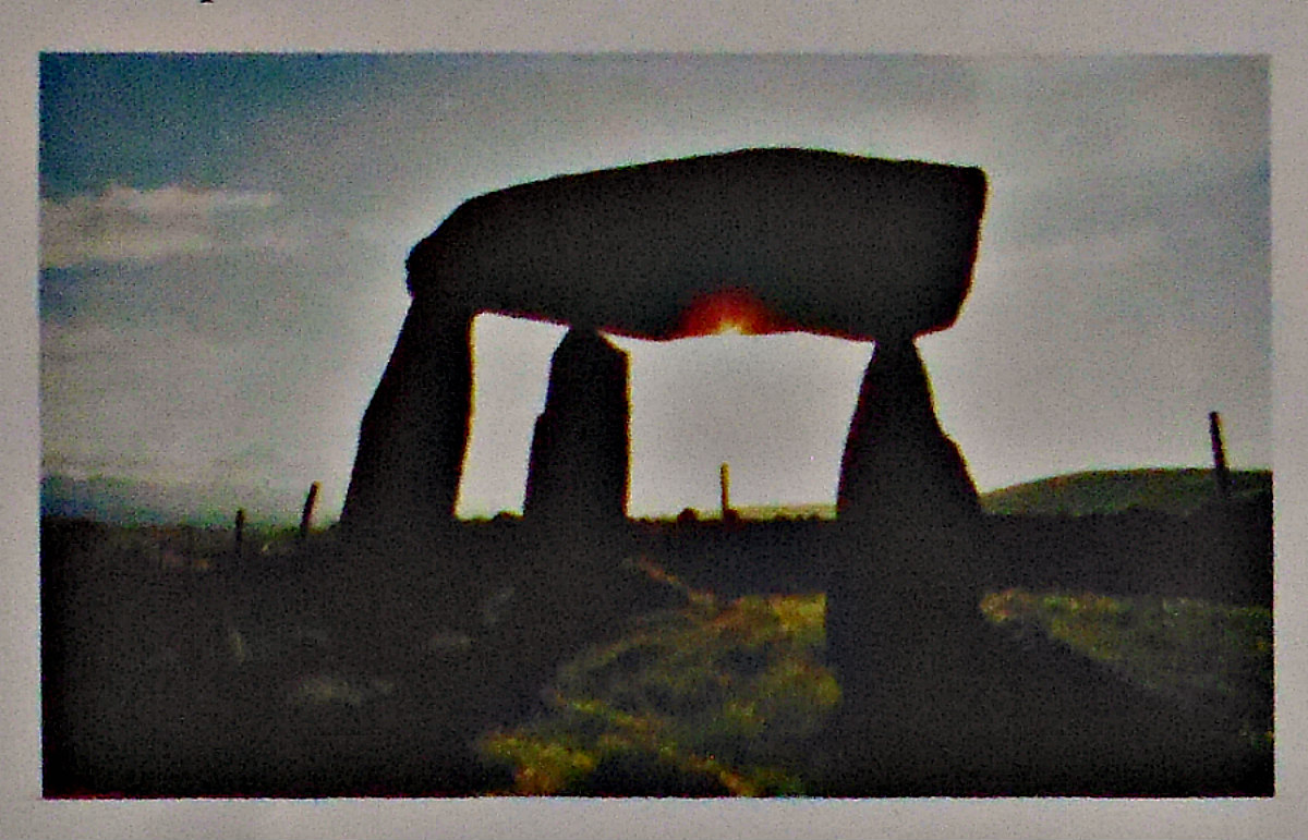
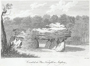
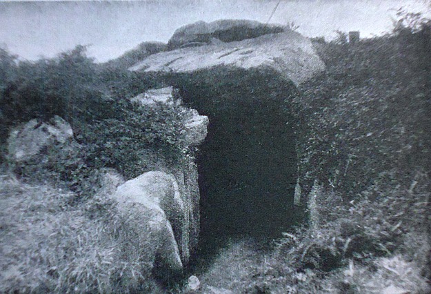
Legananney Dolmen, a Megalithic Tomb in Co. Down, Northern Ireland.

Irish Grid Reference: J 28900 43400. Legananny Dolmen can be found beside a footpath in a farmer’s field between Legananny Road and Dolmen Road on the southwestern slopes of Slieve Croob Mountain, near the village of Leitrim, 3 miles northwest of Castlewellan and 4 miles south of Dromora, in County Down, Northern Ireland. It is also called a Tripod Dolmen (as its huge coffin-shaped capstone is precariously perched upon three upright tripod stones), a Portal Dolmen, and Cromlech. The name Dolmen is derived from “stone table”. This quite amazing prehistoric chambered-tomb monument, dating back 5,000 years to the Neolithic, was probably the burial place of a tribal chieftain; although there is not much left of the mound that once protected and covered the burial chamber. This very graceful-looking monument, which is in State Care, is signposted from Leitrim village, and, it can be reached along a footpath going northwards for 50m uphill from Windy Gap car park on Dolmen Road. Legananny Dolmen has become a much-photographed ancient monument.

Resting on three upright stones, one, in particular, being L-shaped, the over three-metre long capstone points slightly downwards at an angle and rests on the smaller of the three uprights – looking as if it might slide off at any moment! But it is quite safe. It is noticeable, too, that the capstone has straight edges as do the uprights; the taller one being very odd-shaped and wider with an L-shaped cut-away notch.

Reader’s Digest (1992) says: “Legananny Dolmen/Lag an Eanaigh. On the south face of Cratlieve, 850ft above sea level, is a dolmen with a special view of the Mourne Mountains to the south. This is megalithic stonework at its most impressive. Whereas many dolmens are only semi-structured groups of fallen boulders, here the great capstone, 10ft by 4ft by 2ft, stands clear of the ground supported on three stones 7½ft high, looking like a huge tripod.

Sources/References & Related Websites:-

Reader’s Digest, Illustrated Guide To Ireland, Reader’s Digest Association Limited, London, 1992.

The AA, Illustrated Guide To Britain, Drive Publications Limited, London, 1968.

Click on this;  https://voicesfromthedawn.com/legananny-dolmen/

https://en.wikipedia.org/wiki/Legananny_Dolmen

https://niviews.com/2015/02/09/loughbrickland-slieve-croob-legananny-dolmen-and-windy-gap-county-down/

http://freepages.rootsweb.com/~rosdavies/genealogy/PHOTOSwords/DolmenAll.htm

https://www.spottinghistory.com/view/8828/legananny-dolmen/

https://www.alamy.com/stock-photo-legananny-dolmen-co-down-northern-ireland-megalithic-tomb-85663203.html

Copyright © Ray Spencer, The Journal of Antiquities, 2021.


1 Comment

Dolmen of Fontanaccia, Plain of Cauria, Corsica, (France)

Dolmen of Fontanaccia, Corsica, by Cardioceras (Commons Wikimedia)

Latitude: 41.529559N. Longitude: 8.918266E. On the Plain of Cauria (Plateau de Cauria), 15 kms to the southwest of  Sartè (Sartène) on the Island of Corsica, (France), stands the most famous Corsican Megalithic structure: the Dolmen of Fontanaccia, Funtanaccia Dolmen, or ‘Stazzona  del Diavolu’ (the Devil’s Forge), which dates from the late Neolithic/early Bronze Age. This very important prehistoric burial chamber (table tomb) is located in the Dept: Corse-du-Sud, near the end of the D48A road, southwest of Sartène, and near Tizzano on the southwestern coast. From Sartène follow the D21, D48 and D48A roads going southwest to the megalithic monument. The Dolmen of Fontanaccia with its huge, flat capstone-table and six massive stone supports, is thought to be up to 4,000 years old (the 2nd -1st millennia BC). About ½ km to the northeast of the domen is ‘The Alignment de Stantari’, a group of fifteen menhir statues, while 1 km to the south of those another prehistoric site composed of forty-six standing stones known as ‘The Rinaghju Alignment’.

Olivier Jehasse (1992) says of this prehistoric site that: “Between Sartè and the sea, left of the valley which arrives as far as the port of Tizza (Tizzano), extends the high plain of Cauria, an old place of the prehistoric period. This place overhung by a granite mass is above all famous for the Dolmen of Fontanaccia, that the popular tradition transmitted in the last century by P. Merimee, calls ‘”A Stazzona d’U Diavulu”‘ (the forge of the devil). This beautiful monument, well conserved, is composed of 6 slabs which support a table 3.40 meters long and 2.60 meters wide. The room sitting approximately 40 centimeters deep in the earth measures 2.60 meters long, 1.60 meters wide and 1.8 meters high. These funereal buildings, of which a dozen examples are known in Corsica and scattered in all of the western world, are slightly older than the Casteddi which are characteristic of the island’s prehistoric era.  If their roles in the rural communities of the 2nd and 1st millennia B.C. are difficult to understand, the presence of such monuments, in the middle of the plains, or in the hills or at a peak’s edge, bear witness to the presence of social structures on the island, magnified by these collective tombs, dating to late antiquity.”

Jehasse (1992) adds more with regard to the Bronze Age in Corsica, saying that: “Starting from 2200 B.C., the Bronze Age makes a turning point for architectural invention. This island is covered with castles, fortified complexes, and huts grouped around circular or rectangular buildings having various functions. Very well preserved in the south and in the regions of Porti Vecchju, Livia, and Taravu, these complexes are also to be found in Balagne, in the Golu Valley near Ponte Leccia, in the Niolu region and in the hills overlooking the Aleria hinterland. The appearance of these complexes, moreover, is a sign of the transformation of this island society, where human groups differentiate themselves one from another. This evolution is still more clear cut in the area of religion. Collective funerary monuments Stazzoni or dolmens were built. Southern Corsica is once again the region richest in vestiges of these monuments: Stazzona of Funtanaccia and Cardiccia near Sartè, the Stazzona at Taravu and Stazzona of Appiettu near Alacciu. They are also to be found in the northwest in the Agriate region near the village of Santu Pietru of Tenda and in the Niolu region near the village of Albertaccia. This presence of death in monumental form on the peaks and in the highlands is one of the hallmarks of this epoch.”  

About 1 kilometer to the northeast of the dolmen, at the center of the Caurian plain, is another prehistoric site called: ‘The Alignment de Stantari’, a group of fifteen granite menhir statues. These strange carved stones were probably erected some-where between the 13th and 7th centuries BC? Stantari meaning “man on his feet” in the island’s language. The stones measure between 2.78 and 2.91 in height. And another 1 kilometer to the south of these statues is yet another prehistoric site: ‘The Rinaghju Alignment’, which is composed of forty-six granite standing stones in two parallel rows. The tallest stone being 1.50 meters high, according to Olivier Jehasse in her work of 1992.

Sources and related websites:

Jehasse, Olivier, Corsica – Island of beauty, (English Translation: Ilene Steingut), Edition: Plurigraf, Narni – Terni, Italy, 1992.

Photo of Dolmen of Fontanaccia by Cardioceras at:-  https://commons.wikimedia.org/wiki/

https://www.google.co.uk/search?q=The+Dolmen+of+Fontanaccia+in+Corsica+(Wikimedia)&dcr=1&tbm=isch&source=iu&ictx=1&fir=ASbisxkJrL1XIM%253A%252CpTPng18DJJg4KM%252C_&usg=__vaeUDHgVv13_Xpkjoa7G0YoN3Co%3D&sa=X&ved=0ahUKEwiig_T_qq7aAhVIPBQKHb9kCckQ9QEIQzAE#imgrc=ASbisxkJrL1XIM:

https://translate.google.co.uk/translate?hl=en&sl=fr&u=https://fr.wikipedia.org/wiki/Dolmen_de_Fontanaccia&prev=search

http://www2.culture.gouv.fr/public/mistral/merimee_fr?ACTION=CHERCHER&FIELD_1=REF&VALUE_1=PA00099114

http://www.megalithic.co.uk/article.php?sid=9501

http://www.megalithic.co.uk/article.php?sid=9519

© Ray Spencer, The Journal Of Antiquities, 2018.


Brownshill Dolmen, County Carlow, Southern Ireland

Brownshill Dolmen in Co Carlow, Southern Ireland

   Irish Grid Reference: S 75440 76846. In a field a little to the east of the village of Browneshill in County Carlow, Southern Ireland, is the Neolithic monument known as ‘Brownshill Dolmen’ or ‘Brownshill Portal Tomb’ and sometimes as Browne’s Hill Dolmen. But it also goes under the name of Kernanstown Cromlech. The monument has a huge capstone weighing over 100 tonnes, But sadly, however, it has lost its covering mound of earth and a few of its upright supports have collapsed under the enormous weight of the top-stone, although three uprights at the front are still supporting it – two of which form the portal (entrance) to the tomb. The dolmen is located almost 2 miles east of Carlow town near the R726 road. It is best reached to the east of Browneshill village: from the R726 (Hacketstown road) at Ballinakillbeg take the footpath for 550m that heads south from the road, then heads west for quite a distance, and then north to the ancient monument – which stands in the corner of the field.

Brownshill Dolmen. Photo by Sarah777 (Creative Commons).

   The Brownshill Dolmen is really much like a ‘stone table’ or ‘tombstone on legs’ resting horizontally (vertically) on up-right stones’; but it is also called a cromlech and portal tomb (a tomb with an entrance). In the Nicholson ‘Guide To Ireland’, we are told that the: “Browne’s Hill Dolmen……with largest capstone in Ireland, if not Europe, 5 feet thick, 20 feet square and weighing over 100 ton. Two up-right portal stones (orthostats) support the huge granite capstone at the front, while the third supporting stone is a ‘gate-stone’ or ‘blocking stone’; these three entrance stones are between 5-6 feet high. There is a fourth stone at the front which may have been part of the forecourt, although this points at an angle away from the tomb. At the back of the monument two recumbent stones support the capstone near ground-level, but whether these two stones collapsed under the weight or were originally placed like this, is not known. I would think they were placed as such. Originally the tomb was covered by a mound of earth. The megalithic monument is said to be almost 4,000 years old and was the burial place of a Stone Age chieftain, according to Reader’s Digest ‘Illustrated Guide To Ireland’.

Sources of Information and related websites:-

Nicholson, Guide To Ireland, Robert Nicholson Publications Limited, London, 1983.

Reader’s Digest, Illustrated Guide To Ireland, The Reader’s Digest Association Limited, London, 1992. 

https://en.wikipedia.org/wiki/Brownshill_Dolmen                                                                                                                         https://en.wikipedia.org/wiki/Brownshill_Dolmen#/media/File:IMG_BrownshillDolmen.jpg

https://irisharchaeology.ie/2016/04/brownshill-portal-tomb-co-carlow/

http://www.megalithic.co.uk/article.php?sid=6333452

                                                                                       © Ray Spencer, The Journal Of Antiquities, 2017.


1 Comment

Plas Newydd Burial Chamber, Llanfair P.G., Anglesey

Cromlech at Plas Newydd, Anglesey (Drawing)

Cromlech at Plas Newydd, in Anglesey (Old Drawing)

    OS grid reference: SH 5198 6972. Plas Newydd prehistoric burial chamber, cromlech or dolmen, stands just 300 metres north-east of the shoreline of the Menai Straits – at the south-side of the island of Angle-sey and, just opposite Plas Newydd House and Country Park – in whose “private” grounds it is situated. The site is 1½ miles south-west of Llanfair P.G. village and Menai Bridge, which links the Welsh main-land to the island. After the Menai Bridge and link-road take the A5 road, then the  A4080 (Ffordd Brynsiencyn) road to the south-west for 1 mile. Take the first lane that runs off this road (south) to the NT Plas Newydd House. The ancient monument is just 150m to the south-east of the carpark and on private land in front of the big house! And ½ a mile to the south, at the edge of the country park, is a second ancient monument, Bryn-yr-Hen Bobl, which is a chambered cairn.

Cromlech at Plas Newydd in Anglesey (engraving 1799 Wikipedia)

Cromlech at Plas Newydd, Anglesey by Caroline Metz, 1799, Wikipedia)

    There are actually two burial chambers next to each other here, the larger one having a gigantic oblong-shaped capstone weighing many tonnes and measuring 3.5m x 3m, which is supported by five large and sturdy uprights, whereas the smaller chamber’s capstone is 2m x 1.7m and is supported by three smaller, round-shaped boulders. It would seem that the smaller monument acted as an antechamber (passage-way) to the larger monument. These burial chambers are said to date from the Neolithic age. Nearby there are some boulders embedded in the ground – they are probably outliers – and maybe an indication that the burial site once covered a larger area than it does now. There is no sign today of the large earthen mound that would have originally covered these monuments, or did each burial chamber have its own separate covering mound?

    Author Christopher Houlder in his work ‘Wales: An Archaeological Guide’, says of the site: “In parkland overlooking the Menai Strait is a megalithic tomb consisting of a main chamber 3 m by 2.4 m and a smaller antechamber, each with its own capstone, but there is no mound or other feature to give cultural definition.”

    And likewise, author Jacquetta Hawkes, in her book ‘A Guide To The Prehistoric And Roman Monuments In England And Wales’, says of the site: “The Plas Newydd dolmen stands at the end of the drive between the mansion and a cricket field where it commands a view across the Straits. In such a place it at once suggests an eighteenth-century folly, an ornament to the house put up by some romantically minded peer. In truth, however, it is a genuine prehistoric monument of a rather unusual kind; thereare two adjacent chambers, one larger than the other, with very massive uprights and capstones, separated by a single upright. It is possible, though not to my mind likely, that the smaller chamber was originally a passage or antechamber giving access to the larger.”

    Plas Newydd burial chamber were first marked as a cromlech on the OS map of 1841 and as Burial Chamber on the 1947 map, and later ones. There was apparently an early reference and illustration in ‘Druidical Antiquities’ published by S. Hooper in April 1784, which shows two capstones with the larger one resting on five uprights, according to Chris Barber in his work ‘The Ancient Stones of Wales’.

Bryn-yr-Hen Bobl burial Chamber (phot credit: robinLeicester - Wikipedia)

Bryn-yr-Hen-Bobl (photo credit: Robin Leicester – Wikipedia)

    About ½ a mile to the south (OS grid ref: SH 5189 6900) and at the edge of the country park, there is another ancient monument. Again it is on private land. This is Bryn-yr-Hen Bobl, a kidney-shaped grassy mound with a couple of trees on it – and a chambered cairn and funnel-shaped forecourt facing E. There is a revetted terrace some 12m wide extending 100m to the S. This megalithic burial tomb was excavated back in 1929 at which time some ‘earlier’ Neolithic artefacts were found including stone axes, plain ‘western’ and Peterborough types of pottery. “The tomb contained the remains of at least twenty individuals”. (Houlder, 1978)

Sources:

Barber, Chris & Williams, John Godfrey., The Ancient Stones of Wales, Blorenge Books, Abergavenny, Gwent, 1989.

Hawkes, Jacquetta., A Guide To The Prehistoric And Roman Monuments In England And Wales, Cardinal, London, 1975.

https://commons.wikimedia.org/wiki/File:Bryn-yr-Hen-Bobl_Burial_Chamber,_Plas_Newydd,_Anglesey.jpg    This photo is displayed under the terms of the Creative Commons Attribution-Share Alike 4.0 International license.

https://en.wikipedia.org/wiki/Plas_Newydd_(Anglesey)

http://www.coflein.gov.uk/en/site/93829/details/PLAS+NEWYDD+BURIAL+CHAMBER/

Houlder, Christopher., Wales: An Archaeological Guide, Faber, London, 1978.


1 Comment

Heston Brake Long Barrow, Portskewett, Monmouthshire, Wales

Heston Brake Puddingstones (Photo credt: Grashoofd - Wikipedia)

Heston Brake Puddingstones (Photo credt: Grashoofd – Wikipedia)

Os grid reference: ST 5052 8867. Located in a field and on the brow of a hill overlooking the Severn Estuary, south Monmouthshire, stands the more than 4,000 year old prehistoric barrow or cairn called Heston Brake Long Barrow, sometimes also referred to as a “chambered tomb”or “dolmen”. The barrow still has nine of its stones positioned (maybe in situ) on top, but has obviously suffered over time from damage caused by vandals digging into it, although in the late 19th century it was excavated by archaeologists. It is located in a field at Black Rock – about half a mile to the north-east of Portskewett, and just 100 metres to the west of Leechpool Lane. This ‘now’ partly destroyed barrow stands (on private land) about 150 metres south of a footpath heading in a westerly direction from Lower Leechpool Farm on Leechpool Lane. The village of Mathern is some 2 miles to the north-east.

Plan of chambered tumulus at Heston Brake by Mary Ellen Bagnall Oakeley (1888)

Plan of chambered tumulus at Heston Brake by Mary Ellen Bagnall Oakeley (1888)

The remains of the barrow’s two inner chambers (internally connected E and W sides) apparently measured 26 feet long by 5 feet across, according to Fred Hando (in the much acclaimed work ‘Hando’s Gwent’); however the middle section of the monument was destroyed in more recent times. However the 9 standing and recumbent pudding-stones on the 1 metre high mound still look very impressive. It would seem that there were originally 13 upright stones here but 4 of these have now gone – probably being robbed-away to the local area for walls. At the east side (the probable entrance to the chamber) an impressive-shaped stone is 5 foot in height and shaped like a knife or axe-head, while beside it a 2 foot high square-shaped stone (called the chopping block) by local author Fred Hando in the work ‘Hando’s Gwent’, where there is a drawing of  ‘Heston Brake Tumulus by moonlight’ on page 159.  So could this ancient monument have been used for sacrificial/ceremonial purposes back in the Neolithic Age?

All the other stones here are somewhere between 1-2 feet in height; but obviously the low mound on which they now stand would originally have been much higher and would have covered the standing stones by several feet. The mound contained two interconnecting chambers for burials – which revealed various antiquities when it was excavated back in 1888, although at this time it became known that, very unfortunately, earlier vandalism and, or robberies had taken place here, according to Chris Barber and John Godfrey Williams in their excellent book ‘The Ancient Stones of Wales’ (1989). The authors also say that: “It is marked as Long Barrow on the Ordnance Survey maps of  1953 and 1981”.

In the work ‘Wales: An Archaeological Guide’ (1978) by Christopher Holder we are told that: “The present condition of the stone structure and the mound of this chambered long barrow is misleading. Excavations in 1888 showed it to consist of a gallery 8 m long by 1.5 m wide, in the E. end of a barrow 18 m long by 9 m wide”. And it would seem, according to Christopher Holder, that in spite of its position by the Severn, virtually in sight of the Cotswolds, “it seems to belong with Gaerllwyd….. to a tradition of more western origin, distinct from that of the Black Mountains and….. Parc Cwm”.

At the excavations of 1888 a number of human bones were dug up from the earliest period and, some pottery sherds from slightly more recent times. The late author Fred Hando in the work ‘Hando’s Gwent’ adds that: “if you would like to feel cold shivers down your spine, choose a moonlit midnight next summer and visit this long barrow alone”. Okay, thanks Fred, will do that next time!

The late and renowned author Roy Palmer in his epic tome ‘The Folklore of (Old) Monmouthshire’ speculates as to Heston Brake, among a couple of other sites nearby, being the place where the British (Celtic) chieftain Caractacus or Caradoc lived for a time with the ancient Silures tribe in the early part of the 1st century AD, but eventually he went to Rome and died there after being pardoned by the emperor Claudius – sometime after 51 AD.

Sources:

Barber, Chris & Williams, John Godfrey., The Ancient Stones of Wales, Blorenge Books, Abergavenny, Gwent, 1989.

Hando, Fred., Hando’s Gwent, (Ed. by Chris Barber), Blorenge Books, Abergavenny, Gwent, 1987.

Holder, Christopher., Wales: An Archaeological Guide, Faber & Faber, London, 1978.

http://en.wikipedia.org/wiki/Portskewett

Palmer, Roy., The Folklore of (Old) Monmouthshire, Logaston Press, Almeley, Herefordshire, 1998.

Plan of Heston Brake chambered tumulus, Monmouthshire, by Mary Ellen Bagnall Oakeley, 1888, can be found in Volume 2 ‘Proceedings of The Clifton Antiquarian Club’.


Le Creux Es Faies, St Peter Du Bois, Guernsey, Channel Islands

Le Creux Es Faies, Guernsey, Channel Islands (J.Dixon-Scott)

Le Creux Es Faies, Guernsey, Channel Islands (J.Dixon-Scott)

Latitude: 49.456047. Longitude: -2.653499. At the south-western side of the island of Guernsey and just to the north of L’Eree Bay, stands the well-preserved prehistoric monument of Le Creux Es Faies, a huge grassed-over mound which covers an ancient burial tomb, said to date back to between 3,500-2,500 BC. The burial chamber or dolmen is located on the Houmet Nicolle headland a little to the north of L’Eree Bay opposite the island of Lihou, in the parish of St Peter Du Bois, on Les Sablons road. Close by there is a concrete watchtower that was used by German troops during the occupation of the channel islands (1940-45). St Peter Port lies on the east coast about 7 miles from here. On Lihou Island there are some ruins belonging to a Benedictine priory.

Le Crueux Es Faies (Mound of the Fairies) is very similar to the La Varde Dolman, also in Guernsey, and to Gavrinis Tumulus, Brittany. The bottle-shaped passageway is said to be between 8-9 metres long and unusually has a chamber that leads off from the main burial chamber (which is round-shaped), while the long gradually narrowing passage has hefty-looking supporting stones along it sides running the whole length into the tomb and, on top of these at one end, two large capstones. The mound at the north-eastern side has been damaged, possibly during the 2nd world war, the sides of the mound are strenghtened by flat upright slabs placed at intervals with a stonework course between each of the slabs, much like at Gavrinis Tumulus. Originally the mound here at Le Creux would have been much higher, erosion having decreased its overall size. The entrance has a huge slab jutting out over it and the approach has large, almost recumbant stones at either side as you descend down into the darkness of the tomb. Le Creux was probably used for burial purposes from the Neolithic through to the late Bronze-Age.

In local myth and folklore we are told that the (portal) entrance to the mound is the ‘gateway to the fairy kingdom,’ the inner part of the monument being referred to as a ‘fairy grotto.’ Here the little people would go about their daily duties, making bread and keeping house in their own fairy realm, being largerly undisturbed by the world outside! They would only venture out to play when darkness had descended and be back inside by sun rise.

During archaeological excavations in 1840 a number of flint arrowheads were discovered, but little else of interest was found, due quite probably to the tomb being robbed-away by locals or antiquity hunters wanting to make easy money.

Sources:

Newnes Pictorial Knowledge, Volume Seven, George Newnes Limited, London WC2.

The Megalithic Portal:  http://www.megalithic.co.uk/article.php?sid=2076070978

http://www.topicguernsey.com/history


Dolmen De Weris, Wallonia, Belgium

WERIS Dolmen de Wéris (5)

Dolmen de Wéris 1 (Photo credit: Wikipedia)

Latitude 50.333648. Longitude 5.523543. The Neolithic dolmen or burial chamber called Dolmen de Weris no 1 is located near the northern end of the Rue des Dolmens highway in the area called Durbury – close to the Morville and Tour country roads, about a mile to the north-west of the little village of Weris, in the Wallonian province of Luxembourg, Ardennes, eastern Belgium. The megalithic structure stands beside the road partly hidden by trees and is easily missed. This burial chamber is called the Northern Dolmen, Allee Couverte Norde, or Dolmen de Nord. Running in a straight line to the south there is an avenue or double row of menhirs (standing stones) – the monument more or less forms the northern junction of the megalithic avenue itself.

This ancient monument is an impressive structure standing at 5 feet high made from pudding-stone with a massive capstone, sadly now broken, weighing 30 tonnes. It is supported by four huge rectangular-shaped stone blocks or orthostats, two of which weigh up to 20 tonnes. There is an equally impressive gallery (corridor), although quite short, and a rectangular-shaped ante-chamber 33 feet long, which has suffered some damage.  At the eastern end there is a blocking stone, while at the western end a wide portal (entrance) where, on the ground lies a recumbant stone, which originally blocked-off the entrance? Just inside the entrance is a strange curved stone (half-moon shaped) that is broken down the middle. This is called a ‘spirit hole’ or ‘kennel hole’. Near the eastern side there is a single standing stone or, what is perhaps a ‘mark stone’. Originally a mound of earth lay on top of the dolmen but this has now gone. There are a total of 16 stones at this site, which is said to date from 3,000 years BC.

At the south side of the dolmen are two stone rows or an anvenue of 30 menhirs that form an alignment with this – the northern dolmen – and with a curious stone to the north-east called ‘the Stone of the Ancients’ or ‘White Stone’ that is often referred to as a standing stone but, in fact, it is a naturally-formed stone some 3 metres high that leans at a 45 degree angle and stands on a hillside. At the bottom of the hill another stone ‘the Devil’s Stone’ or ‘Devil’s Bed’ is a flatish stone that is 0.6 metres high by 2.45 metres long.

About 2 miles to the south-west near the Route de Erezee (N841) north-east of Wenin we have the Weris (Southern) Dolmen no 2 which is, sadly, now collapsed although the entrance is still quite noticeable. This dolmen is a collection of 20 stones 23 feet long and in a very ruinous state, but similar to the northern dolmen in that it is also a gallery-tomb.

In 1906 the northern Weris dolmen was excavated. Parts of three skeletons were discovered along with other artefacts. However, its stones were not put back into their original positions (in situ) and other damage was caused to the monument. Though, by the looks of things, the archaeologists haven’t done such a bad job! The huge capstone was probably broken at this time as was the spirit-hole?