The Journal Of Antiquities

Ancient Sites In Great Britain & Southern Ireland


1 Comment

Chapel And Fountain: Saint-Anne-La-Palud, Finistere, (Bretagne) Brittany

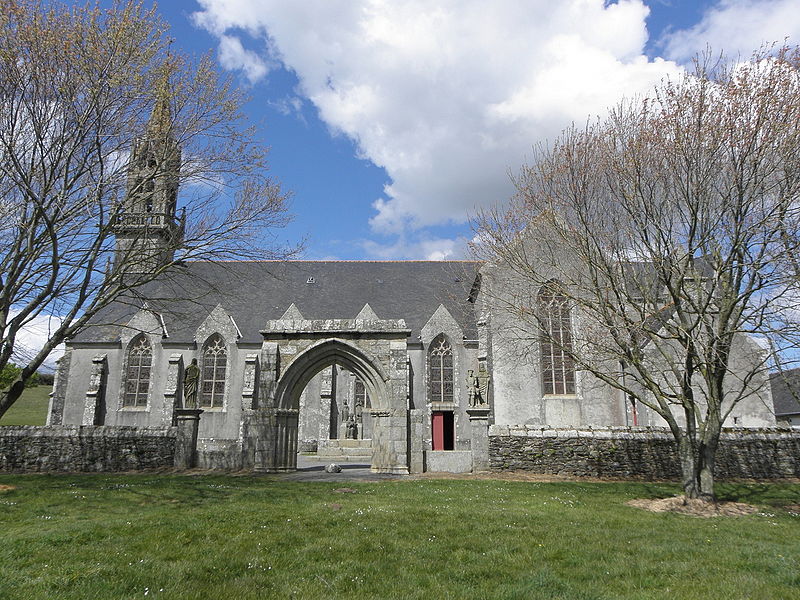
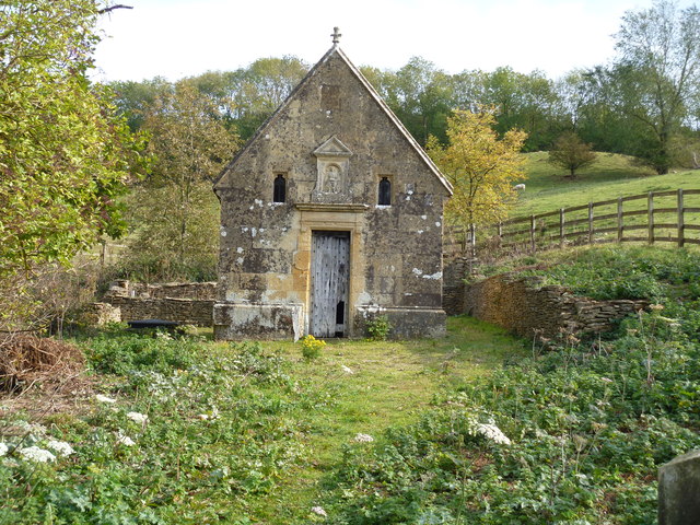
Chapelle-de-Sainte-Anne-la-Palud by GO69 (Wikimedia Commons).

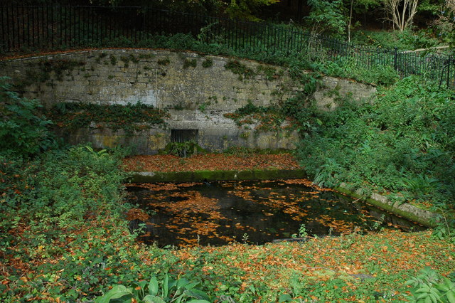
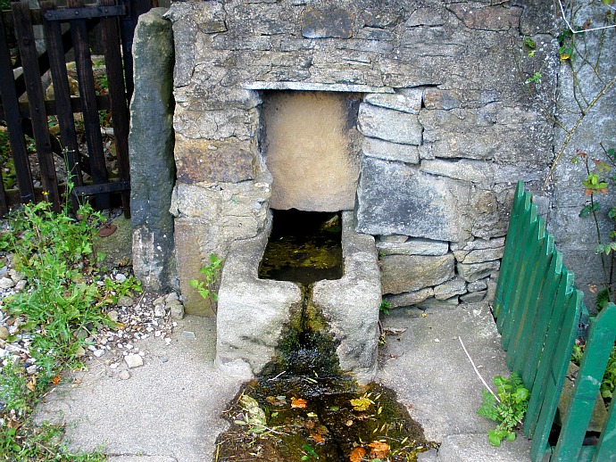
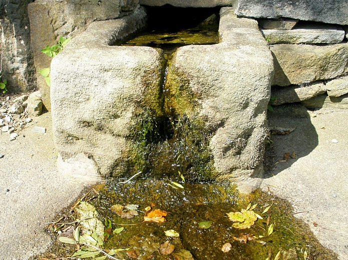
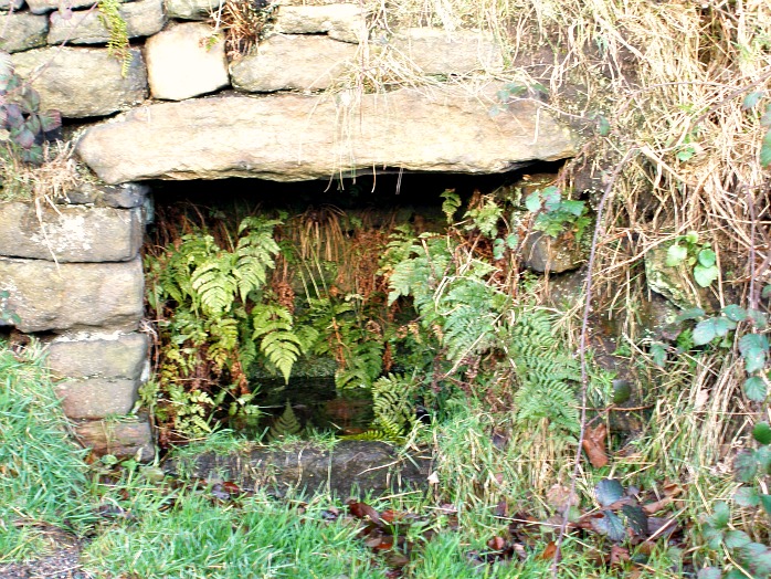
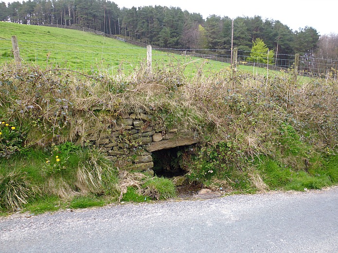
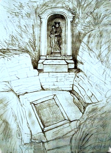
Latitude: 48.135994. Longitude: -4.262185. At the western side of the little Breton village of Saint-Anne-la-Palud in Plonevez Porzay, Finistere, Bretagne (Brittany), 4 miles northwest of Locronan, is the large 19th century Gothic Catholic chapel and pilgrimage centre dedicated to St Anne, mother of the Virgin Mary. The chapel (Kerk) is actually a basilica, and is located on Sainte-Anne la Palud road. There have been several chapels on this site – the first founded by St Guenole in the 6th century may have been nearer the shoreline, in the marshes. To the south of the chapel on Sainte-Anne la Palud road, is St Anne’s Fountain (Fontaine de Sainte-Anne), which has been visited for its miraculous properties for hundreds of years by the faithful from the local area and further afield. A few hundred meters to the west is the coast and beyond that the Atlantic Ocean.

Legend tells us that St Anne or Ana was an Armorican (Breton) woman of noble birth who journeyed to Judea where she gave birth to her daughter, Mary. She is said to have been transported there by angels. Later, she returned to Brittany (after Jesus’ birth) and died there? But this Legend seems to be purely a Mythical one, or it was adapted from the Life of another Breton saint Anna (Ana). In Ireland the Celtic goddess Annu (Danu) of the Tuatha De Danann, seems to have metamorphosed into St Anne. Annu was celebrated in May, according to Colin Waters (2003).

The first pilgrimages to Sainte-Anne la Palud may have began way back in the 5th or 6th century at the behest of the two local saints: Corentin and Guenole. Land for the building of the first chapel dedicated to St Anne was given to St Guenole by King Gradlon. The present-day chapel dates from 1864. In more recent times: from the 17th century onwards pilgrimages have become more prevalent as have the ‘pardons’ in honour of the saint which take place in the sanctuary of the chapel in late July (small pardon), culminating in the ‘Great Pardon’ on the last weekend of August, each year. Then the procession through the village begins and is always well-attended by the local community. During the ‘Great Pardon’ a painted statue of the patron saint, made of granite and dating from 1548, which is much venerated here, is held aloft and carried on its processional journey through the village from the Chapelle Ste-Anne to the 17th century Calvary and, eventually to the Fontaine de Sainte-Anne. 

Michelin (1983), says with regard to the pardons: “The Breton pardons are above all a manifestation of religious fervor. They take place in the churches and chapels, sometimes consecrated by the tradition of a thousand years. There the faithful come to seek forgiveness for their sins, to fulfill a vow or to beg for grace. The great pardons are most impressive, while the smaller, though less spectacular, are often more fervent. It is well worth the tourist’s while to arrange his trip so that he may be present at one of them. It is also one of the rare occasions when he will see the old customs, perhaps slightly modernized. The procession, which begins in the afternoon, is the most curious ceremony: candles, banners and statues of saints are carried by men and girls; with pilgrims singing hymns, priests, the Blessed Sacrament, and sometimes even several bishops. After the procession, the lay festival is given free rain. As a rule this is a rather ordinary fair. Modern dancers are taking the place of the gavotte but bagpipes and bombards still hold their own against accordions and jazz. Sometimes there are wrestling matches, for wrestling is a traditional sport of the Breton peasants.”  

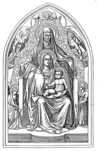
Virgin & child with St Anne by Otto Bitschnau (1883).

Michelin Guide (1983), says with regard to St Anne, the patron of Saint-Anne la Palud that: “The Cult of Saint Anne was brought to western Europe by those returning from the Crusades. Her eager adoption by the Bretons was in part due to the popularity of the Duchess, Anne of Brittany and her later renown. Patroness of Brittany and mother of the Virgin Mary, Saint Anne was originally invoked for a good harvest. The most famous pardon in Brittany, that of Ste-Anne-d’Auray, is dedicated to her, so is the very important one of Ste-Anne-la-Palud and hence the local saying, “‘Whether dead or alive, every Breton goes at least once to Saint-Anne.”‘ A doubtful legend makes St Anne a Cornouaille woman of royal birth who was taken to Nazareth by angels to save her from her husband’s brutality. After having given birth to the Virgin Mary she returned to Brittany to die. It was Jesus who, when visiting his grandmother, called forth the sacred spring of Ste-Anne-la-Palud. The statues usually portray her alone or teaching Mary to read, very often wearing a green cloak symbolizing hope for the world.”  

C. P. S. Clarke (1919), says: “St. Anne was the mother of the Blessed Virgin Mary. The only authorities for her life are the references in three of the Apocryphal Gospels. Her name does not occur in Christian literature until the fourth century. She is said to have been the wife of a rich man named Joachim, but was childless for many years. One year when they came to the Temple for the dedication festival Joachim was upbraided by the high priest for his childless condition. Cut to the heart, and not daring to face the taunts of his neighbours, he disappeared into the wilderness for forty days, and gave himself up to prayer and mourning. Meantime St. Anne remained in Jerusalem. Each had a vision of angels promising a daughter, who was to be called Mary, and was to be dedicated to God from her birth. Many miracles were attributed to her in the Middle Ages, but the observance of her festival was not imposed by authority until 1584. Feast-day July 26th.” 

Rev. Alban Butler (1936), says under the entry for July 26 that: “The Hebrew word Anne signifies gracious. St Joachim and St Anne, the parents of the Blessed Virgin Mary, are justly honoured in the church, and their virtue is highly extolled by St John Damascen. The Emperor Justinian I built a church at Constantinople in honour of St Anne about the year 550. Codinus mentions another built by Justinian II in 705. Her body was brought from Palestine to Constantinople in 710, whence some portions of her relics have been dispersed in the West. F. Cuper the Bollandist has collected a great number of miracles wrought through her intercession.” 

David Hugh Farmer (1982), says of St Anne: “Relics of her were claimed by Duren (Rhineland) and Apt-en-Provence, by Canterbury, Reading, and Durham. The most famous shrine in her honour in England was at Buxton. The Cult has left literary record in three Middle English Lives. It was, and still is, especially popular in Brittany and Canada. Feast 26th July (with S. Joachim); in the East, 25th July.” Henri Queffelec (1972), says regarding Anne Le Berre: “Anne is a name which is given to both men and women in Brittany. St Anne, the mother of the Blessed Virgin Mary, is the Patron Saint of Brittany and the object of special veneration, called pardons in villages like Sainte-Anne-d’Auray and Sainte-Anne-la-Palud.” 

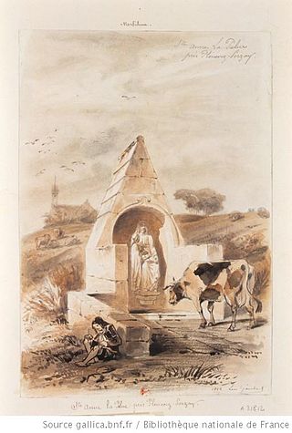
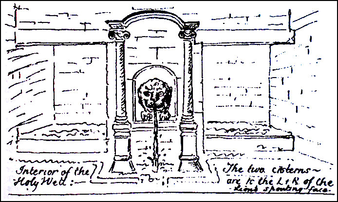
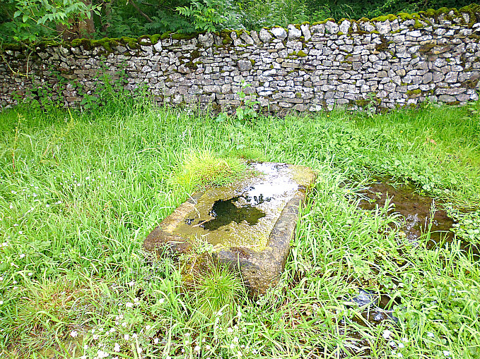
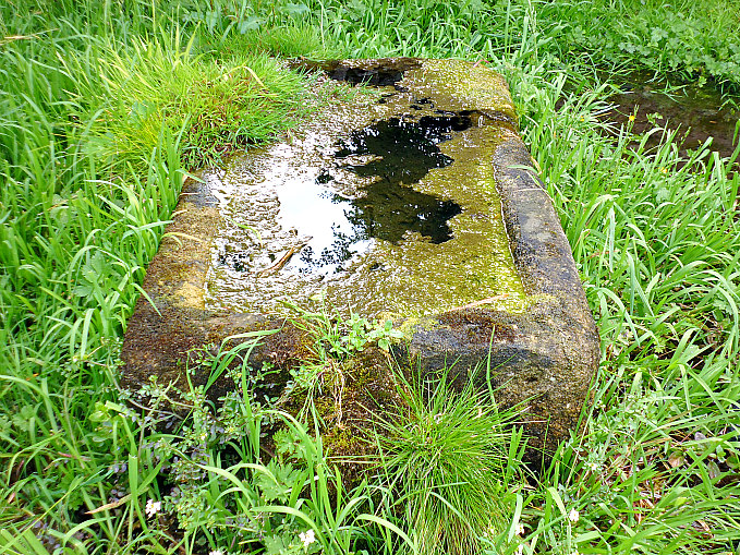
Fontaine de Saint-Anne-la-Palud by Leon Gaucherel 1844.

Fontaine-de-Sainte-Anne or St Anne’s Fountain is about one-hundred metres to the south of Chapelle-Ste-Anne – at the south-side of the road, beside a wooded area. This originated as a spring of water which flowed at the bidding of Jesus, according to the Legend, when he apparently visited, with St John, his grandmother’s place of birth, or maybe she was still living when he came to visit her? The spring or well has been the site of miraculous cures down through the centuries and a place of pilgrimage for the faithful since very early times. It has been claimed that many, or all diseases, were able to be cured by the waters of the holy fountain, but rheumatism being one in particular. Madness and evil were also healed and warded off by the water. A statue of St Anne, on a plinth, with a young Mary at her side stands looking down over the well basin, the present structure of which dates from  1871. The local church pardons process here to the Fontaine-de-Sainte-Anne every year in Late July (small pardon) and the last weekend in August (the Great Pardon).


Sources and related websites:-

Butler, Alban (Rev), The Lives of The Fathers , Martyrs And Other Principal Saints, Volume III, pages 839-40, Virtue & Company Limited, London, 1936.

Clark, C. P. S., Everyman’s Book Of Saints, A. R. Mowbray & Co Ltd., London, 1919.

Farmer, David Hugh, The Oxford Dictionary of Saints, Oxford University Press, 1982.

Michelin, Tourist Guide – Brittany, London & Clermont Ferrand, France, 1983

Queffelec, Henri, Un Recteur De L’ile De Sein, George G. Harrap & Co. Ltd., London, 1972. Originally pub. in French Language (1945) by Éditions Stock.

Waters, Colin, A Dictionary Of Saints Days, Fasts, Feasts And Festivals, Countryside Books, Newbury, Berkshire, 2003.

Photo by GO69    https://commons.wikimedia.org/wiki/Category:Chapelle_de_Sainte-Anne-la-Palud

https://fr.wikipedia.org/wiki/Chapelle_Sainte-Anne-la-Palud

https://en.wikipedia.org/wiki/Saint_Anne

http://www.infobretagne.com/sainte-anne-la-palud.htm

http://fontaines.bretagne.free.fr/presentation2.php?id=95

© Ray Spencer, The Journal of Antiquities, 2018.


High Wall Well, Bramley Meade, Whalley, Lancashire

High Wall Well, Bramley Meade, near Whalley, Lancashire.

   OS Grid Reference: SD 73660 37014. Medieval well in the grounds of the former Bramley Meade Maternity Hospital, near Whalley, in the Ribble Valley, Lancashire. The structure is thought to date back to when Cistercian monks lived at the nearby abbey. It has, however, never been considered to be a holy or medicinal well as such though it was used by the monks and, in more recent times, maybe by the maternity hospital itself. This curious stone grotto-like structure surrounds what appears to be a fairly deep water-filled circular well basin, which may originally have been in use as a “plunge pool”, or in medieval times as a baptistery? A bit of a problem to reach though as its on private land, but you can maybe ask for permission to view the well from the lodge building on Clitheroe Road, or at the main entrance on Wisewell Lane walk up the driveway for a short distance, then turn sharp left and go through the wrought-iron gates (if open) passing the beautifully restored Neo-Classical style water-fountain with carved ladies around its wellhead, which stands in front of the former hospital building; the well is a little further along at the right-hand side on the grassy area. 

High Wall Well at Bramley Meade. Looking down into the well’s circular basin.

High Wall Well at Bramley Meade (the entrance).

   This curious looking well-house with its circular water-filled basin is now perhaps rather forgotten, although it is still of great interest to the town of Whalley in the Ribble Valley. The well-house stands at 8 feet in height and surrounds what looks to be a deep circular basin or plunge pool. It might have been used as a baptistery in late medieval times, but there is uncertainty about that. There are apparently three steps goings down into the water where the entrance is, but I could not see them when I looked down as the water was quite mucky and filled with grass cuttings. It’s an odd mixture of lumps of small and large stones cemented together in a crude sort of fashion to make it look grotto-like, but inside the stonework looks much stronger and more complete and, becoming more circular as the structure tapers downwards, forming the well basin which has the appearance of being more ancient perhaps. At the top of the well-house roof is a sort of crude stone pinnacle. Today, for safety reasons the well entrance has a sort of picket fence barring the way, which is very sensible given the possible deepness of the water.

    Apparently the well was originally called ‘Hey Well’ or ‘Hey Wall Well’ after the area in which it stands; more likely the name has just altered over the centuries and in more recent times become High Wall Well. There is an 18th century map showing the area where the well is situated in a book by Jimmy Fell (1979), who also says the well supplied the abbey. The well is briefly mentioned in History of the County Palatine and Duchy of Lancaster, Volume 3′. In this it is referred to as having no medicinal qualities but was used by the monks “as a cold bath.” And John & Phillip Dixon (1993) give us a few more interesting details about the well. They say that: “High Wall Well is sited inside the grounds of Bramley Mead Hospital. Covered by a grotto-type structure, the waters are reached by descending three steps. It is said to be the clearest and purest spring in the Whalley district, the only one that was never polluted.

   “Perhaps for this reason the Abbey monks laid leaden pipes from the well into their convent, sections of which have been located by the local History and Archaeological Society.”

Sources of information:-

Baines, Edward, History of the Palatine and Duchy of Lancaster (Volume 3), Fisher, son & Company, Lancashire, 1836.

Dixon, John & Phillip, Journeys Through Brigantia, Volume Nine: The Ribble Valley, Aussteiger Publications, Barnoldswick, 1993. 

Fell, Jimmy, Window on Whalley, Countryside Publications Limited, Brinscall, Chorley, Lancashire, 1979.

                                                                                  © Ray Spencer,  The Journal Of Antiquities, 2017.


Robin Hood’s Well, Helmshore, Lancashire

Robin Hood’s Well near Helmshore, Lancashire.

   OS Grid Reference: SD 77860 19544. At the north-eastern edge of Holcombe Moor and beside Moor Road, locally called Stake Lane, 1 mile south of Helmshore, Lancashire, is Robin Hood’s Well/Spring. The well is located at the side of the old pilgrim’s route that led to Whalley Abbey and which passes close to the medieval Pilgrim’s Cross, that is now nothing more than a stone-base on the moor. There are no records to say that Robin Hood’s Well ever had healing powers, or to it being a sacred spring, but it must have had some holiness attributed to it by the monks and pilgrims who visited it and drank of its waters back in the mists of time. And there is nothing that says Robin Hood the outlaw of Sherwood Forest ever visited the well, though there is a Robin Hood’s Inn down in Helmshore village. It may originally have been called Pilgrim’s Well.  To reach it walk south along Moor Lane for 1 mile from the village of Helmshore, or go up the footpath from the B6214 (Helmshore Road) near Pleasant View Farm. Follow the path across the farm track and up over the fields over the wall stiles to the rough track (Stake Lane) at the top. Go through the wooden gate on the right and the well is below the wall in front of you.

Robin Hood’s Well.

Close-up of the pool below the spring.

   The author John Crawshaw writing in Source – The Holy Wells Journal, gives us a fair bit of interesting information with regard to the well. He says that: “Situated near Helmshore, on the edge of the ancient  Forest of Rossendale in Lancashire is Robin Hood’s Well. This well is near an ancient pilgrim’s route which passes by the Pilgrim’s Cross (which was in existence in A.D. 1176), on Holcombe Moor, and goes through the town of Haslingdon on its way to Whalley. In Anglo Saxon times Whalley church was an important minster and the mother church of an enormous parish. Later, in the medieval period, several chapels-of-ease were attached to Whalley church for the “ease” of the scattered population providing access to the Mass and the sacraments

   “After the move made by the Cistercian monks of Stanlow to Whalley at the end of the thirteenth century, traffic would have increased along this route. About one mile to the north of Pilgrim’s Cross, near this pilgrimage route is Robin Hood’s Well.

Pyramid-shaped stone above the well/spring.

   “The spring issues  out from beneath a large, worn stone capping: shaped rather like a flattened pyramid with a blunt apex. This is set against a drystone wall by the side of Stake Lane. The water falls from the well-head into a small pool and the whole arrangement of stones has the appearance of great age. The flattened pyramid-shaped piece of sandstone covering the well has several worn, carved indentations upon it, one of which, near the left-hand side at the front, is a wide groove. It is possible that this was made by the wearing down of the stone by a chain securing a drinking cup at its end. However, no trace of any chain or cup can now be discerned.”

   Mr Crawshaw goes on to say that: “Though it is reasonable to assume that this well was used by pilgrims on their way to Whalley church and later, the great Cistercian abbey there. I have not been able to discover any recorded references to its original dedication: nor does there seem to be any written record reciting any healing properties attributed to the water. It is possible of course that any such references are lost or were never recorded, or perhaps the well’s reputation  in the middle-ages was merely that of a providential source of drinking water on a pilgrim’s route, where prayers were said in gratitude for the slaking of the pilgrim’s thirst.

   “I have a theory that in fact the name of the well may have been brought into use following the 16th century religious reformation. I understand the term , “the play of  Robin Hood” was used by the 16th century Lancastrian religious reformers as a derogatory nick-name to describe the rituals and ceremonies of the old English Catholic Church. These reformers had no use for pilgrimages to holy sites such as the ancient parish churches, the shrines of saints or holy wells; indeed they denounced them as being of no spiritual value.

   “One of the most famous Lancastrian reformers, John Bradford, in his Christmas sermon delivered in Manchester in 1552, threatened the people that, if the town did not “readily embrace the Word of God, the Mass would be said again in that church, and the play of Robin Hood acted there”, ¹ which did indeed come to pass during the reign of Queen Mary. I believe that this ancient spring derives its name from this time, when the practice of visiting such wells was being denounced as “superstitious”.

   “The Elizabethan “settlement of religion”, having swept away the piety and traditional Catholic practices of the old Ecclesia Anglicana, had no use for pilgrimages which, in theory at least, it had outlawed. So, following the dissolution of Whalley Abbey and the official prohibition of the old Faith, this spring on an ancient pilgrim’s route appears to have fallen into being regarded merely as a source of water by the side of a little-used moorland lane.” 

Sources of information and related websites:-

Crawshaw, John, (Robin Hood’s Well), Source—The Holy Wells Journal,  New Series No 6—Summer 1998, Pen-y-Bont, Bont Newydd, Cefn, St Asaph, Clwyd, 1998.

¹ Haigh, Christopher, Reformation and Resistance in Tudor Lancashire, 1975, Cambridge University Press, Ch.11, 168.

http://www.pastscape.org.uk/hob.aspx?hob_id=44289

https://en.wikipedia.org/wiki/Helmshore

https://haslingdens.blogspot.co.uk/2016/01/historic-water-troughs-and-spring-fed.html

                                                                                  © Ray Spencer, The Journal Of Antiquities, 2017.


Hollinshead Holy Well, Near Abbey Village, Lancashire

Well-House of Hollinshead Hall, Lancashire, by Margaret Clough (Wikipedia)

Well-House of Hollins-head Hall, by Margaret Clough (Geograph).

   OS Grid Reference SD 6637 1992. About a mile south-east of Abbey Village, near Blackburn, Lancashire, stand the scant ruins of Hollinshead Hall, a 14th century building that was actually a manor house and home to the famous Radcliffe family of Ordsall near Manchester. In the enclosed garden of the ruined hall is a well-house containing a holy well that used to have healing properties.The origins of the name Hollins-head probably derived from the Saxon place-name ‘Holy Head’ or even ‘Helig Weald’ which refers to a holy well or spring. Though the name ‘Holy Head’ might perhaps be derived from the well-head – the stone lion’s head in the well-house from the mouth of which the water issues. The well-house was probably a baptistery to which Roman Catholics resorted to during Penal times when priests were in hiding and any form of gathering in such a place was outlawed. Follow the Tockholes Road south out of Ryal Fold for about ½ a mile, then walk along the track on the right-hand side through the woods for 335 metres leading to the ruins of the hall, farmhouses, gardens and the medieval well-house.

   The author John Crawshaw writing in Source – The Holy Wells Journal, gives us a fair bit of interesting information with regard to the holy well. He says that: “The early history of the well is scanty, but it seems that a medieval well-house (with a superb vaulted stone roof) was ‘restored’ at some date during the 17th century.

   “This  restoration was probably carried out by the owners of the land on which the holy well stood, the powerfull recusant Radcliffe family of Ordsall Hall near Manchester.

Hollinshead Holy Well (illustration by John Crawshaw).

Hollinshead Holy Well by John Crawshaw.

   Mr Crawshaw goes on to say that: “Unfortunately, though I have been researching its history for some years now, I have not been able to discover the holy wells’ dedication, which has been lost. Doubtless the site was very important, for the well-house itself is very grand indeed, and houses two baths in the form of rectangular cisterns, and there is also a fine retaining wall to the right of the compound, bearing traces of the Radcliffe coat-of arms. A member of the Radcliffe family lived in a house near the site, and it is highly probable that the well-house was a secret mass-centre and baptistery, a focus for recusant life in the area. I believe that there is sufficient evidence in the style of the building to show that is is a ‘disguised’ holy well house, perhaps built when persecution became a little easier during James the second’s reign: at any rate the style of the building is very much that of c. 1680s Lancastrian master masonry.

   “On the hillside, immediately behind and above the well-house, is a pool which probably represents the original holy well. It is a pretty big pool, oval-ish, and lined with ancient stones. The spring issues from the earth at the right-hand side, fills the pool, and from thence the water falls down into the two cisterns within the well-house itself.

   “Hollinshead Holy Well has a vague reputation of being haunted and also that its very pure water is good for eye troubles. Hollinshead Hall is referred to in Twycross’ Mansions of England (1846), where the well-house is mentioned, said to have been formerly called ‘The Holy Spring’, and visited by pilgrims who came for the water.

    Mr Crawshaw says of his visit to the well: “Visiting it on 18th October 1994, I was delighted to find that the holy well-house had not been vandalized, as I been informed recently. It is still in good order, except for some obscene graffiti and the fact that the door to the well-house is now locked with a large padlock, so that access……..is not now possible. However, the interior of the well-house can easily be seen through the two windows in the façade. The original pool behind the well-house is still full of water, and access to this pool is unrestricted.

   “The well is still referred to locally as a ‘Holy Well’, and I was present, back in late September 1988 at a well-dressing ceremony (the very first one to be held) at the Well. This was organized by the local Anglican priest, and very well con-ducted it was, too, says Mr Crawshaw.

   Author Richard Peace in ‘Lancashire Curiosities’, puts the question with regard to the holy well: Pagan or Catholic Spring? He says that: “Amidst the gardens of the ruined Hollinshead Hall lies a well-preserved outbuilding housing a stone carved lion’s head that emits a small spring of water. The spring falls into a central channel, surrounded by cisterns and benches on either side. This fascinating building is Hollinshead Well, whose original purpose is hotly debated. Its origin seems likely to be ancient. The vaulting inside may be from the 15th century whilst the covering is from the 18th century. Some believe it to be of pagan origin as it reportedly contains the water of five separate  springs, signaling the presence of the water-goddess. More recently its seems to have been used as a Catholic baptistery, with the two cisterns perhaps being used for male and female baptisms. Records show medieval pilgrims visited the well to try and cure ophthalmic complaints.”

   The author Edward J. Popham, writing in 1993, says this holy well used to be known as Ladyewell (Our Lady’s Well) and then locally called St Leonard’s Well. Presumably he is referring to the Hollinshead Well? It seems that he is.

Sources and other related websites:-

Crawshaw, John, (Hollinshead Hall Holy Well),  Source—The Holy Wells Journal, New Series No 2—Winter 1994, Pen-y-Bont, Bont Newydd, Cefn, St Asaph, Clwyd, 1994.

Peace, Richard, Lancashire Curiosities, The Dovecot Press Ltd., Stanbridge, Wimborne, Dorset, 1997.

Popham, Edward J., Where Shall We Go In The Ribble Valley? The Salford Catholic Truth Society, 1993.

    https://en.wikipedia.org/wiki/Hollinshead_Hall#/media/File:The_Well_House,_Hollinshead_Hall_ruins_-_geograph.org.uk_-_116184.jpg

http://people.bath.ac.uk/liskmj/living-spring/sourcearchive/ns2/ns2jc1.htm

https://en.wikipedia.org/wiki/Hollinshead_Hall

Holy Well, Hollinshead Hall, Tockholes, Lancashire

Hollinshead Hall ruins and Well House, near Tockholes

                                                                                © Ray Spencer, The Journal Of Antiquities, 2017.


1 Comment

St Helen’s Well, Draughton, North Yorkshire

St Helen's Well, near Draughton, North Yorks.

St Helen’s Well, near Draughton, North Yorks.

    OS grid reference: SE 0274 5326. In the corner of a field close to a wall beside the busy A59 road ½ a mile north of Draughton, north Yorkshire, is the ‘now’ much neglected and almost forgotten St Helen’s holy well. The well or spring, or what remains of it, is located close to Holywell Halt on the heritage railway line that is run by The Embsay & Bolton Abbey Steam Railway; the pretty little halt and the bridge opposite are both named after the well. The site can be reached from the A59 road between Skipton and Bolton Bridge. It is on the Draughton side of the road just before the railway bridge and on the opposite side of the road from the lay by. A wall stile hidden underneath some trees and bushes gives access to a footpath which passes close to the well. However, beware of the main road as there are vehicles coming along at often fast speeds.

St Helen's Well near Draughton, North Yorks.

St Helen’s Well near Draughton, North Yorks.

    St Helen’s holy well or spring is now very neglected and almost forgotten. It is in fact a large stone trough or tank measuring about 5 feet in length by about 2 feet wide, with a curved outlet at one end, and it looks to be quite deep. A metal pipe used to supply the stone trough with water from ‘a spring’ in the grassy bank opposite, but this has now gone and so the trough is replenished by rain water and overflows onto the surrounding ground which, at the time of my visit, was flooded with muddy water and very boggy. But when the ground is dried out I believe a flat area of ground with stones and pebbles can be seen around one side of the stone trough. Unfortunately, the stone trough is now used by thirsty cattle! The well was mentioned by Guy Ragland Phillips in his work ‘Brigantia’, in the mid-1970s.

    So just how old is this holy site and has St Helen or Helena (248-330 AD) always been associated with the well? At a guess I would say it is Medieval although the spring was here way, way back. It was obviously a pre-Christian spring. So maybe the saint, who was the mother of the Roman emperor Constantine the Great, was accepted as patron of the spring here in the the early Medieval period – at which time the cultus of St Helen was particularly strong in the Craven Dales. There is another St Helen’s Well at Eshton near Gargrave, north Yorkshire. But we know that St Helena was ‘not’ a native of Yorkshire, nor was she from anywhere else in Britain – despite what some early scholars say.  She was born at Drepanum in Bithynia, Asia Minor, later to be called Helenopolis. St Helena journeyed to the Holy Land and according to tradition she re-discovered the true cross (Holy Cross) on which Christ was crucified.

Sources and related websites:-

http://www.halikeld.f9.co.uk/holywells/north/holywl1.htm

http://www.le.ac.uk/users/grj1/helen.html

https://en.wikipedia.org/wiki/Helena_(empress)

Phillips, Guy Ragland, Brigantia, Routledge & Kegan Paul Books, London, 1976.


St Kenelm’s Well, Winchcombe, Gloucestershire

St Kenelm's Well near Winchcombe BY Michael Dibb (Geograph).

St Kenelm’s Well near Winchcombe by Michael Dibb (Geograph).

    OS grid reference: SP 0435 2779. About 1 mile east of Winchcombe village, Gloucestershire, on the side of a hill stands St Kenelm’s holy well. The wellhouse-cum-baptistry which houses the holy well is a mid-16th century building. The well takes its name from St Kenelm, a Mercian boy-king and martyr, who was the grandson of King Offa. He was ‘most treacherously’ murdered at the instignation of his scheming elder sister, Quendrida, sometime between 819-821 AD. It is located on the side of a hill which is surrounded by trees on its lower sides, and is easily reached along a country lane that runs in an easterly direction out of Winchcombe village, passing close by Sudeley Castle. A footpath runs just to the west of the well-house. The holy well was a place of pilgrimage in the Middle Ages and in more recent times too, as was Winchcombe Abbey, where the martyr’s coffin had lain for many hundreds of years. It is now housed in St Peter’s parish church.

    Francis Duckworth recalls the “Legend of St Kenelm” in his beautiful book ‘The Cotswolds’, and says: “Kenulf, King of Mercia, founded Winchcombe Abbey in the 9th century. He had a daughter, Quenride, and a son, much younger, Kenelm. The latter, while still a child, succeeded his father, and  the jealous Quenride at once began to hatch plots to put him out of the way. One fine morning he went out hunting with his tutor, and never returned. So Quenride reigned in his stead.

    “Some years afterwards, while the Pope was celebrating mass in St Peter’s, a pure white dove flew in through an open window, and let fall a piece of parchment from her bill. On the parchment was written: “In Clent, in Cowbach, Kenelm, Kinges bermn (bairn) lieth under a thorn heuade birevede (bereft of his head).” An Englishman who happened to be present interpreted this, and the Pope set on foot an investigation of the whole matter. In the end a party of monks from Winchcombe succeeded in finding the headless of Kenelm. At this  point the monks of Worcester interfered, and claimed the body as having been found within their boundaries. Divine arbitration was implored. Both claimants should sleep one night by the body’s side: the first to wake should possess the relic. This good fortune fell to the Winchcombe monks. On their way they stopped to rest, and the spot is marked by St Kenelm’s Well.”

    St Kenelm’s murder took place at Romsley in the Clent Hills, Worcestershire, where another holy well sprang forth where the saint’s body had lain. This well is located in the valley behind St Kenelm’s church, which is about½ a mile north-west of the village, according to authors Janet & Colin Board ‘Sacred Waters’. On its long journey from Romsley in Worcestershire the martyr’s body had been rested, only a mile from Winchcombe Abbey, Gloucestershire, but this simple action caused a second spring of water to burst forth and soon miracles of healing were attributed to its water. The well water was said to be most effective as a cure for eye troubles. Above the door of the stone-built wellhouse is a statue of St Kenelm, who today surveys what would have been his kingdom, but sadly ‘that’ wasn’t to be. The present-day building dates from 1549 and it was restored in 1887.

    Author Francis Duckworth goes on to say that after Kenelm’s murder: “Quenride sat at her window to watch the procession pass, and, to cast an evil spell upon it, read aloud the 100th Psalm backwards. When the procession reached her window her eyes dropped out of her head into her lap, and stained the psalter with blood. This psalter was preserved and shown for many years in proof of the story. Kenelm was buried in the abbey precincts, and one of the two very early stone coffins in the west end of the parish church is called Kenelm’s coffin.” The other coffin was thought to be that of King Kenulf (Coenwulf), father of St Kenelm (Cynehelm). Winchcombe abbey was founded by King Kenulf in 789 or 798 AD, but it was dissolved in 1539. Nothing survives of the abbey above ground. The evil Quenride, also known as Cwenthryth lived out the rest of her ‘sad’ days in a monastery, where she was ‘perhaps’ made abbess? She died in 827 AD. St Kenelm, the boy-king, is still much venereated at Winchcombe – where is feast-day is held on 17th July.

    Over the years there has been much speculative debate on the age of Kenelm when he succeeded his father to the throne of Mercia. We can assume that he came to the throne in either 819 or 821 AD at the age of 7 or 9, if he was born in 812 AD which is the date usually given, although some historians think he was a few years older than that, maybe as old as 12? Not that it really matters now!

Sources:

Bord, Janet & Colin, Sacred Waters, Paladin, London W1, 1986.

Bottomley, Frank., The Abbey Explorer’s Guide, Kaye & Ward, Tadworth, Surrey, 1981.  

Duckworth, Francis., Beautiful Britain – The Cotswolds, A. & C. Black Ltd., Soho Square, London W1, 1914.

http://www.geograph.org.uk/photo/2767417     © Copyright Michael Dibb and licensed for reuse under this Creative Commons Licence.

https://insearchofholywellsandhealingsprings.wordpress.com/2012/03/19/st-kenelms-well-at-winchcombe/


Mossy Well, Muswell Hill, Haringey, London

Os grid reference:  TQ 288 899. A few miles to the north of the city of London, in Haringey district, is the London suburb of Muswell Hill (NW10), which takes its name from an ancient healing well (long ago) called Mossy Well or Moss Well and, later in the 12th century it was “perhaps” re-named by some local Augustinian nuns who built their chapel there – calling it St Mary’s Well at Muswell. Or could the name actually be derived from the river Moselle, locally called  ‘the Mose’, which ‘springs to life’ in Hornsey (on Moss Hill), just to the south-east of Muswell Hill, and which was long known for its medicinal qualities, though it is in fact a brook. But are the two actually one and the same, probably not. The healing well (known as St Mary’s Well) has long since been capped under the ground, with only the place-name still there to remind us of this once holy, pilgrimage site. Today a private house (no 10 Muswell road) stands on the ‘presumed’ site halfway along the road. Muswell road is located just west of Alexandra Park and the famous Alexandra Palace, while to the north is Muswell Hill Golf Course, and a mile to the south Highgate Cemetery.

Mossy Well is described as being a natural spring, but undoubtedly in early Christian times it was used by the local community which would, at that time, have been just a settlement, though it must have had healing and beneficial qualities, maybe this was attributed to the ‘moss that grew in it’ or around it? Then, later in Saxon times it would have become a proper healing spring with people coming to visit it from farther afield. And in the 12th century some nuns came to the area and built a dairy farm; they saw the holy well, built a chapel beside it, and re-named both after St Mary the Virgin. After this time, in the medieval period, the well became a place of pilgrimage with healing occurring at the well, and votive offerings being made in the chapel, to Our Lady.

There is a legend that was told back in Tudor times which stated that: A Scottish king came to the Mossy Well and was cured of a disease there by drinking of the water, but there is no date given. The only other more recent record comes from a book called ‘Old London, Spas, Baths and Wells’, by Septimus Sunderland. What is known is that the Bishop of London gave some land to the Augustinian nuns of St Mary’s priory at Clerkenwell on which to found a chapel beside a healing well at Muswell – the place then became a Roman Catholic pilgrimage site with numerous cures being wrought there. The chapel was destroyed in the 16th century under the orders of King Henry VIII.

Sources:

http://www.londonslostrivers.com/muswell-stream.html

http://en.wikipedia.org/wiki/Muswell_Hill

http://en.wikipedia.org/wiki/River_Moselle_(London)

http://www.muswell-hill.com/n10biz/info/history.html

Sunderland, Septimus., Old London, Spas, Baths and Wells, John Bale, sons & Danielsson, London, 1915.


2 Comments

Rosamond’s Well, Blenheim Park, Woodstock, Oxfordshire

Fair Rosamund's Well, Blenheim (Photo Credit: Philip Halling - Geograph)

Fair Rosamund’s Well, Blenheim (Photo Credit: Philip Halling – Geograph)

Os grid reference: SP 4365 1647. At the north-side of the lake in Blenheim Park at Woodstock, Oxfordshire, is Rosamond’s Well, also known as Fair Rosamund’s Well. It takes its name from Lady Rosamond de Clifford who was to become the lover (Mistress), for her sins, of King Henry II, although probably not ‘entirely’ out of her own choosing! Fair Rosamond, it is said, was “supposedly” murdered by a very jealous Queen Eleanor in about 1175, or was she? But back in the 12th century the well was called Everswell, maybe because it was ‘never ever’ known to run dry, even in the driest spells of weather; and in the past the water had some curative properties as pilgrims were wont to come here and partake of it in bottles – in those distant times, but in fact the well has only been named after Rosamond since the 16th century. The village of Woodstock is a quarter of a mile east of the well, while Bladon is half a mile south, and the town of Long Harborough 2 miles south-west on the A4095 road.

Godstow Nunnery Ruin (Photo Credit: Wikipedia)

Godstow Nunnery Ruin (Photo Credit: Wikipedia)

Poor Rosamond was buried at Godstow nunnery, a house of Benedictine nuns dedicated to St Mary and St John the Baptist, which is now in ruins beside the river Thames, near Oxford. It was founded by the widow Edith Launceline in 1133, dissolved in 1539, and almost destroyed during the Civil War in 1645 or 46. Today the ruin acts as a pound for local farm animals. There are only fragmentary remains of the precinct wall and chapel of abbess’ lodging, according to Frank Bottomley in his book ‘The Abbey Explorer’s Guide’, 1981. The nunnery ruins are two-and-a-half miles north-west of Oxford city centre.

Today the well looks quite neat and tidy, and is surrounded by a fence, in what is a very tranquil setting close to the north bank of Blenheim Lake – in the green and wooded grounds of Blenheim Palace. The well is actually a large square-shaped pool paved all around with flat paving stones, while at the head of the pool a high, curving wall with carvings, and a square opening for the water to issue into the pool itself; the water then flowing out into the lake. Foliage and trees grow at either side of the structure, which is soon to be restored. The water is usually quite near to the top of the pool, indeed it is never known to go down by much nor to dry up when there is a prolonged spell of dry weather. Close by is Rosamond’s Bower where Lady Rosamond, daughter of Walter de Clifford, lived before her untimely death (in strange circumstances) at the age of 35 in the year 1175 – murdered, according to the legend, by Queen Eleanor after she had found out that Fair Rosamond was her husband’s concubine. However, it is said that only the king knew the route to Rosamond’s secret bower, a sort of underground labyrinth built for her by King Henry.

Fair Rosamond was buried at the Benedictine nunnery of Godstow in Oxfordshire. In the book ‘A Thames Companion’ by Prichard & Carpenter, the authors say: “On the main stream of the river, Godstow comes next with its ruined nunnery and legend of Fair Rosamond, of which Aubrey wrote (in a manuscript note inside his copy of Plot’s Natural History of Oxfordshire, now in the Bodleian Library): This Rosamond, ye fair daughter of Walter Ld. Clifford, and forced to be Concubine to K. Henry ye 2d, who builded for her at Woodstock an house or Labyrinth under the ground, much wherof at this day is to be seen as also is a goodly Bath or Well, called to this day Rosamund’s Well. In the end she was poysoned by Q. Elianor, some write, and being dead, was buried at Godstow in a house of Nonnes besides Oxford. Not long since her grave was digged, where some of her bones were found, and her Teeth so white (as ye dwellers there report) that the beholders did much wonder at them.”

Sources:

Photo Credit: © Copyright Philip Halling and licensed for reuse under this Creative Commons Licence.

Geograph: http://commons.wikimedia.org/wiki/File:Fair_Rosamund’s_Well,_Blenheim_-_geograph.org.uk_-_1015851.jpg

Wikipedia: http://en.wikipedia.org/wiki/Godstow

Bord, Janet & Colin., Sacred Waters, Paladin Books, London W1, 1986.

Bottomley, Frank., The Abbey Explorer’s Guide, Kaye & Ward Ltd (The Windmill Press), Kingswood, Tadworth, Surrey. 1981.

Prichard, Mari & Carpenter, Humphrey., A Thames Companion, (2nd Edition), Oxford University Press, Oxford OX2, 1981.


Jennet’s Well, Calversyke, Keighley, West Yorkshire

Jennet's Well near Keighley.

Jennet’s Well near Keighley.

Os grid reference SE 0464 4185. Jennet’s Well stands beside a house at the west end of Shann Lane, almost opposite Calversyke reservoir, on Black Hill to the west of Keighley, West Yorkshire. It has variously been called St Jennet’s Well, Jannet’s Well and Jenny’s Well, but as to whom it was originally named for is now lost in the mists of time. Jennet was thought to have been a tutelary Saxon saint who was venerated at Keighley, perhaps at a church that no longer exists, but there is no record of a saint of this name here and so Jennet must be regarded as an obscure or unknown saint. Could it be the word “Jennet” meant something entirely different? Legend says the well at Black Hill stands at a Christianized place, maybe where people in Saxon times could congregate, worship and receive a miraculous cure by the waters of this little holy well, which had become a Christianized spring because a holy person had dwelt there; the spring then having the power to cure illnesses. The town of Keighley is about 1 mile away to the south-east and Braithwaite village roughly half a mile in the same direction.

Close-up of Jennet's Well.

Close-up of Jennet’s Well.

The spring of water flows out from a stone structure and into a square-shaped stone basin that looks to have some faint carvings on it which resemble those from the late Anglo Saxon period; it then runs along a stone gulley, afterwhich it apparently runs under the lane and then on into the Calversyke reservoir, close by. It obviously pre-dates the house by many hundreds of years, but may originally have been used as a source of water by the occupants and others close-by – indeed there are a few records saying the well used to supply the town of Keighley when it was brought to peoples’ homes in stone troughs from the never-failing spring at the west side of the town, according to Stephen Whatley’s ‘England’s Gazetteer’ of 1750. Local folklore says the well was the haunt of the fairy folk in times gone-by. If you are going to look at the well or take photos there [please respect the privacy of the occupants of the house]. There are two other holy wells in this area: True Well and Goff Well.

Sources:

Dewhirst, Ian., A History of Keighley, Keighley Corporation, 1974.

Many thanks to the The Northern Antiquarian:  http://megalithix.wordpress.com/2008/12/29/jennets-well-keighley/

The Megalithic Portal:  http://www.megalithic.co.uk/article.php?sid=26416

Whatley, Stephen., England’s Gazetteer,  J & P Knapton, London, 1750.


Jinny Well, Newchurch-in-Pendle, Lancashire

Jinny Well, Newchurch-in-Pendle.

Jinny Well, Newchurch-in-Pendle.

OS grid reference: SD 8238 3946. A few hundred yards down the hill from the Pendleside village of Newchurch-in-Pendle along Jinny lane, and set into the grassy bank is Jinny Well or Jennet’s Well, a sacred spring that has been here for some considerable time from when the land was first formed in geological terms. Not a great deal is known about it today, perhaps because in our modern times with clean drinking water on tap, it has been largerly forgotten, sadly. At the time of my visit the well was looking a bit overgrown. From the top of the village Pendle Hill can be seen 2 or 3 miles to the north-west, while the village of Sabden is 4 miles further to the west and Barrowford is roughly 3 miles to the east.

The well is built into the grassy bank at the side of Jinny Lane – it’s roof is formed from a thick stone-slab and a large stone basin collects the water, which is nowadays a dirty-brown colour and “certainly not” suitable for drinking, while at the other side and also above, the structure is made out of drystone walling; the spring comes out of a small grassy hillock in the field above the well. At the front there is a horrid iron grid to collect any overflowing, cascading water. Undoubtedly, at one time long-ago the well water was used by local people because of it’s purity and, maybe it had some health-giving qualities of which we know little about today.

Jinny Well, Newchurch-In-Pendle

Jinny Well, Newchurch-In-Pendle

According to local legend, the lane is haunted by the headless ghost of a woman called Jinny, Jinnet or Jennet; and she has given her name to the well and the lane, but as to when she lived around here, again, we do not know, only the legend and name remains. Maybe Jennet still uses the well for her needs in the realm where ghosts and spirits (water spirits) preside. Jennet does not appear to have been accorded the title of ‘saint’ in this case, even though she lost her head! There are a few other wells and springs in the pretty village of Newchurch-in-Pendle, in particular there is said to be a well in the garden of St Mary’s vicarage/parsonage.

Source:

Bennett, Paul., The Northern Antiquarian, 2009. http://megalithix.wordpress.com/2009/11/08/jinny-well-pendle/


Lyd Well, Kemble, Gloucestershire

Commentarii de Bello Gallico, an account writt...

(Photo credit: Wikipedia)

Os grid reference SO9896 9847. The ancient spring known as Lyd Well, Lydwell and sometimes the Roman Well is located in the corner of a field between the A433 (Tetbury road) and the A429 (Crudwell-Malmesbury road) about half a mile north of Kemble village. It is a short distance south of the old disused Thames and Severn canal, beside an area of trees and bushes and an old wind-pump. The name ‘Lyd’ is Old English and means ‘loud well’. In the dry, summer months it is difficult to find, but in a long wet spell of weather it is in full flow. This is now considered by historians to be the source of the river Thames, rather than at Thames Head 1 mile to the north-west where the water has given up the ghost and where all there is to be seen today is a small circle of stones on the ground and a hidden stone gulley close by. Even the reclining statue of ‘Old Father Thames’ had to be re-located from Thames Head to St John’s lock at Lechlade due to vandalism, in 1974; and a bit further north-west is Seven Springs on the river Chun, another possible source of the Thames? with at least 5 of the springs still evidently flowing into a large 8 foot-high stone-built pool. Here a latin inscription on a stone tablet claims that this is the actual true source: HIC TUUS O TAMESINE PATER SEPTEMGEMINUS FONS. The other problem being that there are several springs in this particular area just to add to the confusion, some of these are said to be at least 14 foot deep, and even as much as 30 feet deep in some cases.

Cirencester (Corinium Dobunnorvum) Roman town and the Fosse Way are another 3 miles due north-east of Lyd Well and, so the theory is that Roman soldiers would have known this spring and may have even placed offerings into the water; certainly they would have drank of the once clear, cold water after a long march along the nearby Roman road, a short section of the Fosse Way linking up with Exeter (Isca Dumnoniorum) in the south-west of England and running in a north-easterly direction towards Lincoln (Lindum), which is now the section of the A433 road between Kemble Airfield and Cirencester. A number of objects of Roman antiquity have been found in the Thames. To the Romans the river was referred to as Tamesa or Tamesis – this being the first recorded account in ‘Commentarii De Bello Gallico’ the written work of Julius Caesar’s exploits in Britain in the early days of the Roman Empire (55-54 BC). But in the Celtic Age the river was probably a derivative name for Tame and Isis (Tameisis) old pagan gods or a single river divinity of myth and legend. The first ‘real’ record of Lyd Well comes from ‘The Doomsday Book‘ of 1086 AD.

Statue of Father Thames, alongside St John's L...

Old Father Thames,  Lechlade, (Photo credit: Wikipedia)

The spring called Lyd Well emerges from a large circular hole covered with an iron grate and flows out into an even larger stone-lined pool which is often overflowing or ‘positively gushing’ with water; the quickly flowing water then heads along a water course that gradually gets more and more noticeably like a stream and, after some miles forming something more like a river in one’s eyes towards Cricklade. In wet weather the gushing, thundering water is quite forceful and very loud – hence the name Lyd Well. Long ago the water was clear and, probably drinkable, but this is not the case today and it’s “not” advisable to drink it. I don’t know whether the water ever had any healing qualities, apart from being cold and crystal clear to drink when one was very thirsty – maybe up until the 17th century or earlier than that at least.

In the 16th century John Leland the noted royal antiquarian came to view the sources of the Thames and, later in the late 18th century William Combe also viewed these river sources and wrote about them in his celebrated work ‘History of the Pricipal Rivers of Great Britain’ (1794). No doubt other notary people from the last two hundred years or so have also tried to find the true source of the river Thames.

Sources:

Prichard, Mari & Carpenter, Humphrey., A Thames Companion, (2nd edition), Oxford University Press, Oxford, 1981.

Bord, Janet & Colin., Sacred Waters, Paladin (Grafton Books), London, 1986.

Combe, William., History of the Principal Rivers of Great Britain, John & Josiah Boydell, London, 1794.

http://thames.me.uk/s02380.htm

http://en.wikipedia.org/wiki/Fosse_Way


Walsingham, Norfolk

English: The statue of Our Lady of Walsingham,...

(Photo credit: Wikipedia)

Os grid reference TF9360 3678. Walsingham the famous English ‘Marian’ shrine and pilgrimage centre in north Norfolk is actually made up of two villages, Little and Great Walsingham, some 5 miles north of Fakenham and 20 miles east of King’s Lynn on the A148. In the grounds of the Augustinian priory ruins at Little Walsingham just south of Holt road, founded in 1153, 1162 or 1169? by Geoffrey de Favarches, are two holy wells that were dedicated to the Blessed Virgin Mary (Our Lady of Walsingham), but today these have, sadly, become wishing wells. Geoffrey de Favarches, son of Richeldis who had visions of the Virgin Mary in 1061, having visited the Holy Land had vowed to build a religious house on his land at Walsingham when he returned to England. He did not go back on his vow. Geoffrey was also associated with endowing Castle Acre priory in Norfolk, which had been founded earlier in c.1090 by William de Warenne, Earl of Suffolk.

The two healing wells are located just a short distance to the east of the turreted monastic archway, all that remains of the priory church (east side gable end), now a rather forlorn looking ruin standing all alone, but which in earlier times was a very grand religious house that had strong links to the shrine of Our Lady (which had stood at the north side of the priory church) and the healing wells. There are other ruins here, notably the west end of the refrectory, dating from around 1300, and other ruins including gatehouse and frater. To add to the religious buildings, a Franciscan friary was established in 1347, as a hospice for poor travellers, under the patronage of Elizabeth de Burgh, Countess of Clare, despite much opposition from the Augustinian canons of the priory who thought this would be a distraction for pilgrims coming to their house. Walsingham priory was dissolved in 1538 even though King Henry VIII had himself earlier visited the ‘Catholic’ shrine and left a candle burning there! – the friary was abandoned at the Dissolution in the same year, although some ruined walls from that building are still visible including guest-house and church, but today these stand on private land.

It was here in 1061 that the lady of the manor of Little Walsingham, Richeldis de Favarches, who had earlier been married to a Norman lord, had at least three visions, one of the Virgin Mary on her own who instructed her to build a replica of the holy house (Santa Casa) at Nazareth, one of St Mary with baby Jesus and another of St Joseph. This was done and a chapel and wooden shrine were established two years later. During the middle ages Walsingham became something of a place of pilgrimage and, this even more so in later centuries when kings, queens, the nobility and also the poor and disabled came to the Slipper Chapel, at Houghton St Giles, on what was the best known of the pilgrim routes to complete the 1 mile journey to the Roman Catholic shrine itself without shoes (barefooted). The Slipper Chapel fell in to ruin in 1538, but was restored by the local Catholic community in the 1890s; and later in 1914 it became the National Catholic Shrine to Our Lady – to where thousands of pilgrims come every year from all over the world. The Slipper Chapel houses a very lovely statue of the Blessed Virgin Mary and baby Jesus.

During the 14th and 15th centuries Walsingham had become known as ‘little Nazareth’ and even the ‘English Holy Land’- such was the fame of the place at this time in history. In 1931 an Anglican shrine was established near the priory ruins and a well was discovered where the foundations were to be built – this well was rather ‘curiously’ found to be connected up to the two healing wells, and so it too has curative properties. Today it is a renowned place of pilgrimage for Anglo-Catholics, Roman Catholics and, the Orthodox Churches, both in this country, and in Europe. According to the author David Pepin in his book Discovering Shrines And Holy Places, “For many twentieth-century pilgrims the annual pilgrimage to Walsingham is a highlight of the Christian year”. And it still is in the 21st century.

The two circular healing wells, with a larger square-shaped pool between them began to flow “again” at the instigation of the Blessed Virgin Mary, having been dried up for some considerable time; they were almost certainly pre-Christian, pagan springs. Our Lady instructed the saintly and, wealthy widow, Richeldis, to build a shrine and chapel that would represent the holy house at Nazareth; from which time the water in the two stone basins, close-by, became ‘effacious with healing qualities’ that would miraculously cure such ailments as: stomach problems and headaches etc. There also existed a chapel of St Lawrence at or beside the healing wells, but this has long since vanished. The small Romanesque entrance with a round-headed doorway and nice carvings was re-erected here in the 19th century but it originally stood eleswhere as part of the priory buildings. The two wells are covered with decorative iron lids and the larger bathing pool is often covered over. Also at one time a worshippers stone stood between the wells to allow pilgrims to sit and perform their usual water rituals.

Sources:

Butler, Lionel & Wilson-Given, Chris., Medieval Monasteries of Great Britain, Michael Joseph Limited, London, 1979.

Bord, Janet & Colin., Sacred Waters, Paladin (Grafton Books), London, 1986.

Reader’s Digest., Folklore Myths and Legends of Britain, (2nd Edition), Reader’s Digest Association Limited, London, 1977.

Pepin, David., Discovering Shrines And Holy Places, Shire Publications Ltd., Princes Risborough, Aylesbury, Bucks, 1980.

Bottomley, Frank., The Abbey Explorer’s Guide, Kaye & Ward Ltd., London, 1981.

http://www.catholictradition.org/Mary/walsingham.htm

http://www.feorag.com/wells/hope/norfolk.html


1 Comment

Our Lady’s Well (Ladyewell), Fernyhalgh, Lancashire

By Andrew Henderson

OS grid reference SD 55612 33622. Our Lady’s Well (Ladye Well) at Fernyhalgh can be reached along a narrow country lane (Fernyhalgh Lane) to the east of the A6 and M6 motorway, some 4 miles north of Preston. Fernyhalgh is a hamlet situated between the villages of Broughton and Grimsargh, with pleasent countryside on all sides. The holy well of Our Lady is in the garden of the 17th century Ladywell House which houses a Roman Catholic chapel and retreat centre. It is located at the side of the secluded Fernyhalgh Lane that runs south for about ½ a mile from D’Urton Lane. The entrance to the well and shrine is through a little gate almost hidden at the side of the retreat centre building.

There was a chapel on this site way back in 1348 and possibly a shrine dating back to the 11th century. The spring itself is obviously a Christian one, with it’s dedication to Our Lady the Blessed Virgin Mary, and possibly a pre-Christian spring. According to the legend, in about 1471 a merchant sailing across the Irish sea was caught in a terrible storm; afraid that he was going to drown he prayed to the Virgin Mary and vowed that if his life was saved he would undertake some work of devotion to Her. Soon the storm cleared and he found himself washed-up but safe on the Lancashire coast, but he had no idea where he was. At that moment a heavenly voice spoke to him and told him to find a place called Fernyhalgh and there build a chapel at a spot where a crab-apple tree grew the fruit of which had no cores, and where a spring would be found. He began to search around for this sacred place but no-matter how much he tried he could not find it.

The merchant found lodgings in Preston and, was about to give up altogether, when he overheard a serving girl at the inn. She started to explain why she was so late on arrival. She went on to say that she had had to chase her stray cow all the way to Fernyhalgh. The merchant asked her if she could take him to this place. In a short time he discovered the apple tree with fruit bearing no cores and beneath it a spring and also a lost statue of the Virgin and child. He set about building a chapel close by in memory of Our Lady and soon pilgrims were visiting the holy well and receiving miracles of healing. However, during the time of persecutions in the reign of King Henry VIII and through to that of King Edward VI the well was abandoned and left derelict, and the chapel itself was sadly demolished.
.
Lady Well, Fernyhalgh

Lady Well.

The holy well of Our Lady was, however, fully restored in the late 17th century and a new chapel (the Martyrs Chapel) was built in 1685 when persecutions towards Catholics had eased. Again the place became a place of pilgrimage and many miraculous cures were being recorded there. The chapel (which is upstairs in Ladywell House) was used by religious sisters as a place of retreat and is still used today; it houses some of the relics of the English Catholic martyrs. Today, it is a renowned Roman Catholic pilgrimage centre and Marian Shrine, with thousands of visitors coming from far and wide.

The holy well stands within a rectangular enclosure with steps descending down; the well itself being a small square-shaped basin overlooked by a statue in a stone-niched surround of the Virgin Mary holding baby Jesus. The well and shrine were restored to what we see today between 1905-1954 by the religious sisters, and it is still very well cared for by volunteers in the local Catholic community, with flowers usually adorning the well-shrine during the Summer months. Coins are sometimes thrown into the well although ‘it is not’ regarded as a “wishing well”. Visitors are always welcome and, you don’t have to be a Catholic, everybody regardless of what religious persuasion they might be can visit the well and shrine.
.
Edward J. Popham, writing in 1988, says of this place: “To the north of Watling Street road and near to Preston is a place known as “Fernyhalge”. The name is a combination  of two Anglo-saxon words, namely “ferny” meaning ancient or old and the word “halgh” which means shrine. In the Prologue to Chaucer’s “Canterbury Tales”, he states that in the spring people  go on pilgrimage to “ferna halwes” (ancient shrines). Why the Anglo-saxons called this place an “Ancient Shrine” is unknown; but they must have had a good reason for doing so. The most reasonable explanation  is that on this site once stood an ancient shrine to a Roman Goddess; but that after the King of Northumbria was baptized at York on Easter Day in A.D. 627, the site was converted into a shrine to Our Lady. It is generally accepted that the shrine of Our Lady at Glastonbury is the oldest Marian shrine north of the Alps; but it is quite possible that the Shrine of Our Lady of “The Ancient Shrine” at Fernyhalge may be older. This shrine was regularly and frequently visited by Catholics in Penal Times. Their faith in Mary was undoubtedly a source of their courage and fortitude.”
.
Sources and related websites:-
.
Bord, Janet & Colin Sacred Waters, Paladin Books, 1986.
Popham, Edward, J., (assisted by Margaret Panikkar), The Osbaldeston Saga, 1988. With illustrations by Andrew Henderson.
 
Popham, Edward, J., Where Shall We Go In The Ribble Valley, The Salford Catholic Truth Society, 1993.
Fields, Ken, The Mysterious North, Countryside Publications, 1987.
With thanks also to The Northern Antiquarian.
                                                            © Ray Spencer, The Journal Of Antiquities, 2017.


The Mousse Fountain, Aix-En-Provence, France

English: Fountain on the Cours Mirabeau' in Ai...

The Mousse Fountain, Aix-en-Provence, France (Photo credit: Wikipedia)

Latitude 43.526901. Longitude 5.449895. About midway along the tree-lined Avenue Cours Mirabeau at the corner of the Rue Clemenceau in the town of Aix-en-Provence, dept of Bouches-du-Rhone, France, stands the now famous hot thermal fountain and spring The Mousse Fountain, which is also known as ‘La Fontaine Deau Chaude’ and ‘Fontaine sur le Cours Mirabeau’. There are three other famous fountains close by: Fontaine de la Rotonde (19th century) in the Place de General de Gaul at the west end of the avenue is probably the largest, while Fontaine of the Nine Cannons (17th century) stands halfway between the two, while at the eastern end is the 19th century Fontaine du Roy Rene, but there are other fountains in the town. The seaport of Marseilles is approx 20 miles to the south and Pertuis is 10 miles to the north on the E712 highway.

The Mousse Fountain is a naturally-formed thermal spring with its source at nearby Bagniers from where it travels deep underground to “spring-up” on the Avenue Cours Mirabeau in Aix-on-Provence. But the fountain’s shaped basin dates from more recent times – 1734 to be precise. The huge round boulder sits in the basin and is covered in moss and foliage – this probably dates from the dawn of time in geological terms. From this the fairly hot, steaming water issues through various orafices from which people can drink the water; whereas people with certain “diverse ailments” can use the water in the basin. The hot water here can, apparently, cure all manner of ailments such as nervous disorders, stomach disorders, rheumatism and some gynaecological conditions, but the water is quite hot and is known to reach a temperature of 94 farenhite or more. Sometimes a strange thick foam gathers on top of the water and is locally referred to as “mousse”, from which the name is derived, though this is said not to be in any way harmful to humans.

The Romans under Gaius Sextius made good use of the hot thermal springs when they invaded this part of Gaul back in 121 BC after driving out the Celtic-Ligurian tribe from their settlement at Etremont just north of the town – the town at that time being on the Via Aurelia which linked northern Spain with Gaul. In the medieval period the thermal springs were a great potential for the town with pilgrims coming from all over the country to partake of the healing waters and, in more recent times this has largerly continued, mainly because Aix-en-Provence became a thermal spa-town, with hot water baths (giving a water temperature of upto 97 farenhite) that were built upon Roman foundations on the Rue du Bon Pasteur and, which again are said to be very effective for numerous diseases and bodily disorders.

Source:-