The Journal Of Antiquities

Ancient Sites In Great Britain & Southern Ireland


St John The Evangelist, Escombe, County Durham.

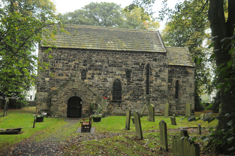
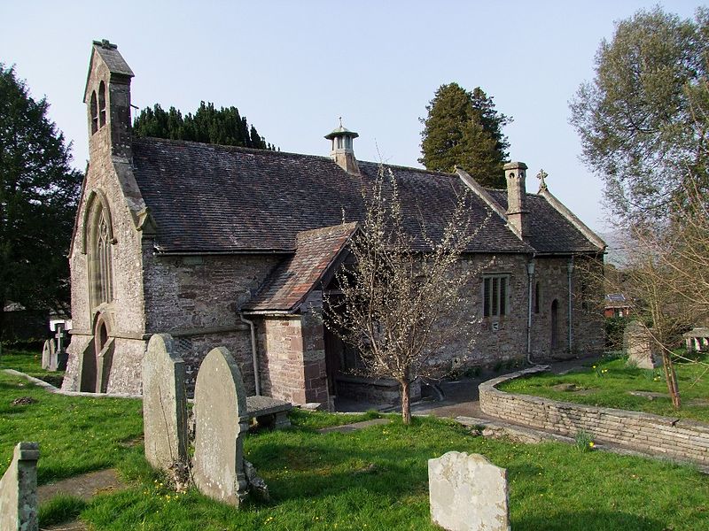
Escombe Church near Bishop Auckland. Photo is courtesy of Anne T.

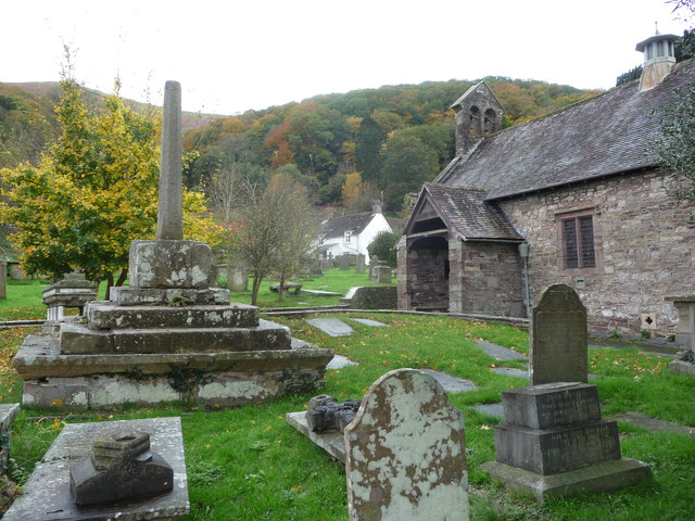
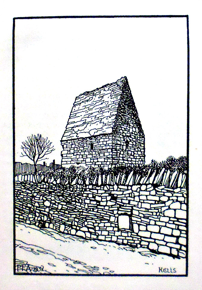
NGR: NZ 18929 30139. The well-preserved little church of St John the Evangelist, Escombe, stands on Saxon Green in the middle of the village of Escombe, in Co Durham, and is 2 miles to the west of Bishop Auckland. There has been a church on this site since 670-75 AD and there is still much early Saxon work to be seen inside and outside the present church, in-cluding some Anglo-Saxon crosses, which date from the 7th-10th centuries AD, but St Bede does not mention it. Some Roman inscribed stones built into the outer walls obviously date from several centuries before the actual church. The churchyard is roughly circular so this little church must stand on a sacred site. Much of the stonework of this 7th-century building came from the nearby Roman Fort of Binchester (VINOVIUM), which stood on the bank of the River Wear. St John’s has seen various periods of restoration, particularly in 1875-80, when the roof had to be restored. At the SW side of Bishop Auckland take the B6282 for a couple of miles. Stay on this road S and then W, then take the country road heading N to the village of Escombe – St John’s Church is near the centre of the village on Saxon Green.

Nigel & Mary Kerr (1982) tell us that: “The little church of St John is an excellent example of early Anglo-Saxon work. Standing tall and austere in an almost circular churchyard, its majestic antiquity is unmarred by the tasteless modern houses which sur-round it. This is one of the best-preserved Anglo-Saxon churches in England and, apart from a short break during the last century, worship has probably continued here for 1,300 years.  Nothing is known of the foundation of the church, and the dedi-cation is unhelpful. The main fabric is of 7th-century date, and some have claimed that its simplicity shows continuity from Celtic timber buildings. The Venerable Bede makes no mention of the church in his History of the English Church and People which was finished in 731. This has led some to question the early dating, but Bede only mentioned churches germane to his narrative, so the omission is not critical.

“The gables of the nave have been restored; the ‘crow step’ pattern may therefore be later. The walls are over two feet (61 cm) thick and 23 feet (1 metre) high. Huge quoin-stones, some  nearly two feet (61 cm) high and three or four feet (1 metre) long, are set on edge and extend along each wall alternately; hence the name ‘side alternate’ quoins. Many of  the stones show character-istic Roman diamond tooling and were doubtless taken from the nearby fort at Binchester. A steeply pitched roof line, perhaps of a porch, can be seen on the west wall. The blocked doorway in the north wall of the chancel led into a small chapel, called a porticus, which was excavated in 1968. The present south porch is later. Just to the east of it, high up in the wall, an original sundial may be seen, decorated with a carving of a serpent.

“Internally, the lofty nave is complimented by a tall chancel arch, a further example of re-used Roman work. The small chancel has a simple Saxon carving behind the altar. The four Saxon nave windows, round-headed on the south side and square on the north, are strongly splayed internally to admit more light. They are now glazed, but vertical grooves for wooden shutters show the original arrangement; some window glass was found during the excavation of the north porticus, however. A small section of early cobbled flooring is preserved at the west end of the nave.  As Escombe is older than St Lawrence’s at Bradford-on-Avon and Odda’s Chapel at Deerhurst, it is the earliest largely complete Anglo-Saxon church in England, and well worth a visit.”  

Arthur Raistrick (1972) says that: “Escomb church stands one and a half miles to the west of Bishop Auckland, on the south bank of the Wear. It is the only parish church of the seventh or eighth century, in this country, still surviving in its entirety. It is small but very high and plain, and achieves a great dignity. The nave is long and high, with a nearly square chancel beyond it, separated by a chancel arch of carefully fitted well-cut long and short work. These very large blocks are probably taken from the Roman fort of Vinovia, Binchester, not far away. The windows are very small and very deeply splayed on the inside, two on the north side with straight heads, and two on the south with round  heads. A few later windows have been inserted to light the building. 

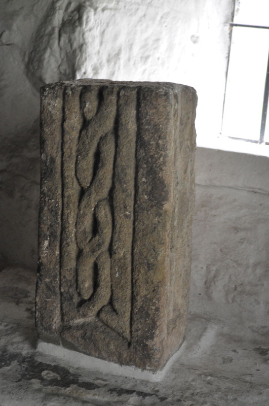
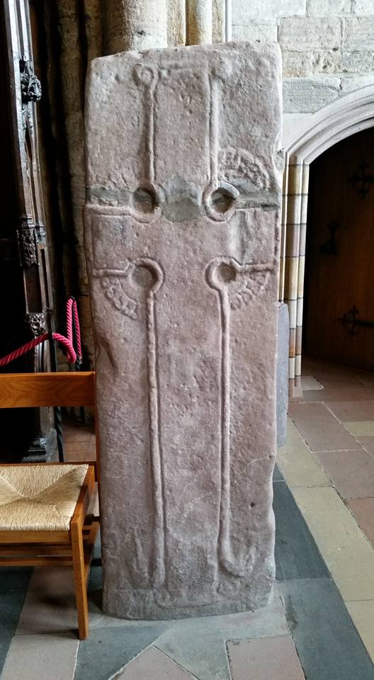
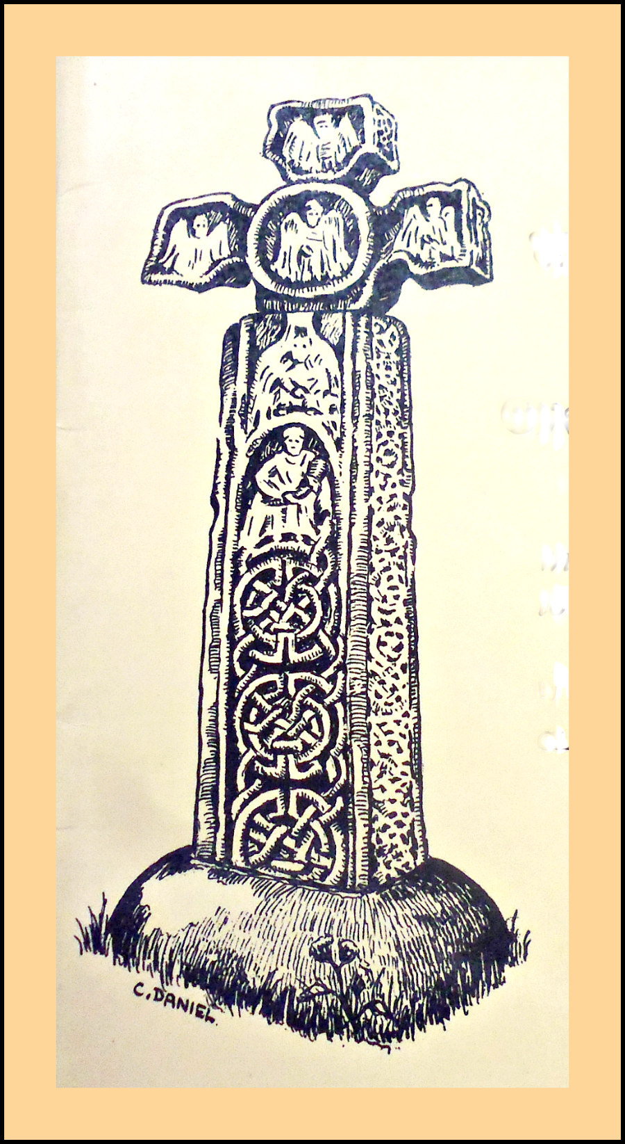
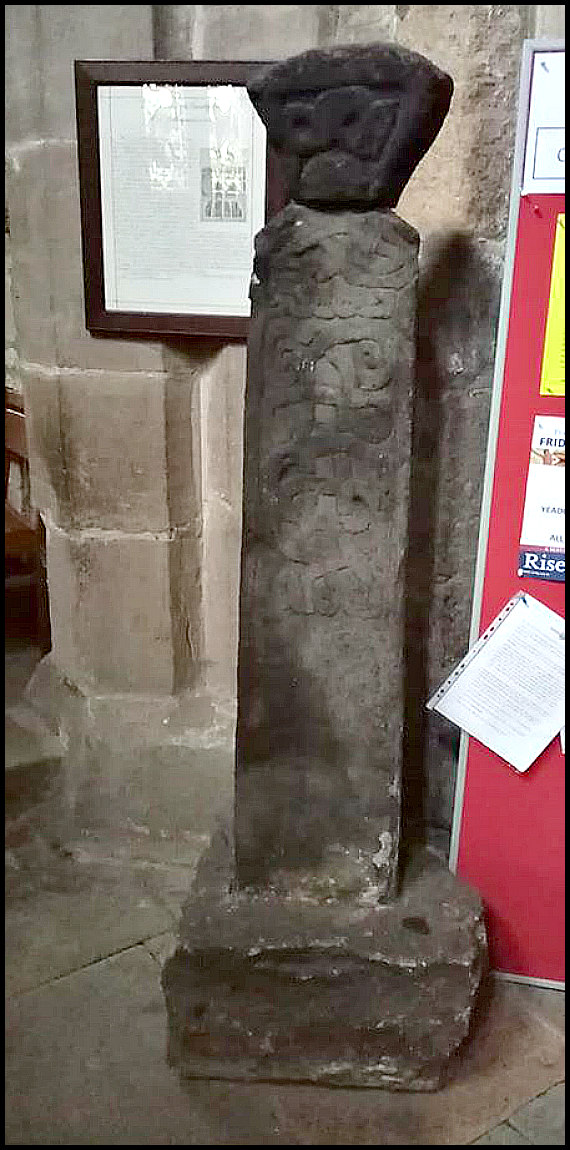
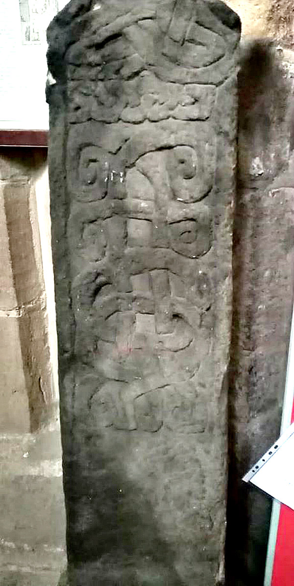
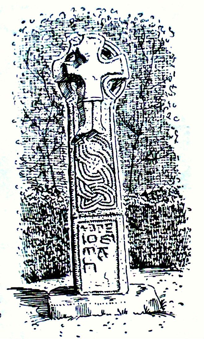
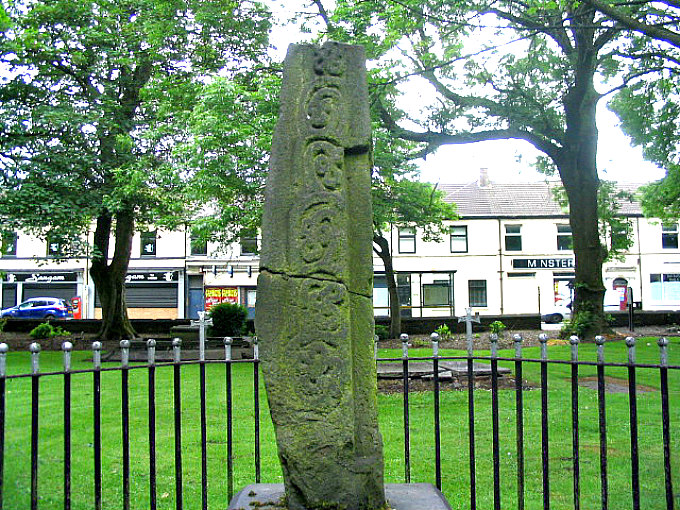
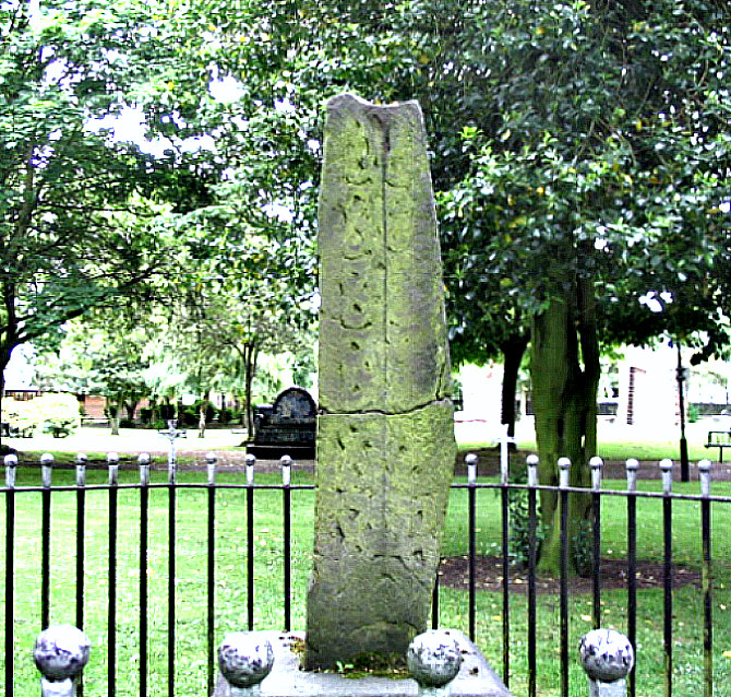
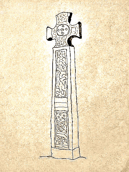
Escombe Cross. Photo: Anne T.

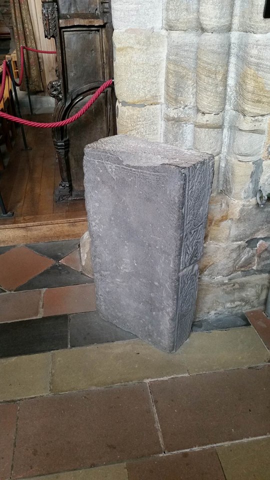
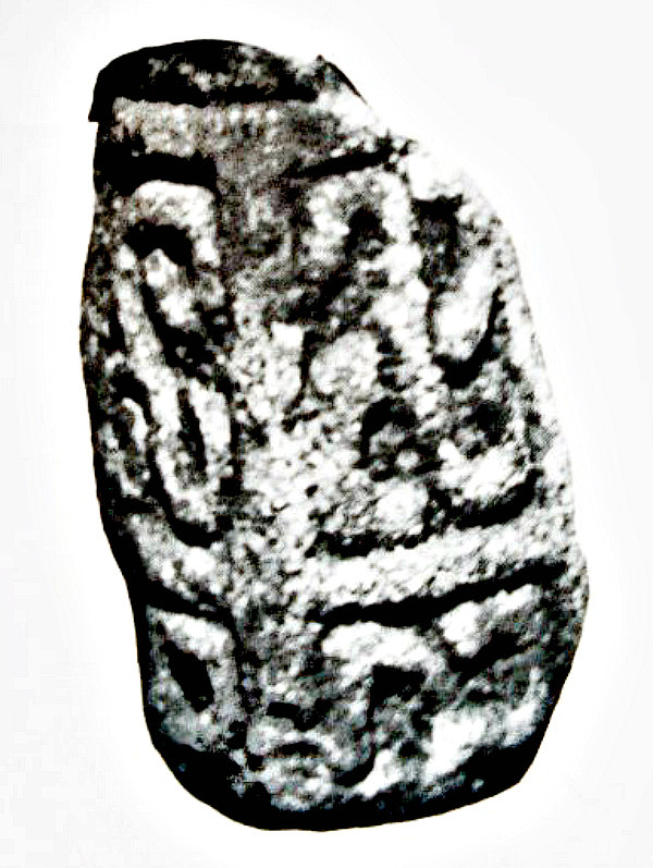
In the church porch there’s a beautifully carved section of a cross-shaft which is said to date from the late 7th to early 8th century AD, and might have been part of a taller preaching cross that once stood outside the church, while located behind the altar is an incised cross-slab, or was this a grave cover, from the 9th century AD; this may have originally stood outside the church and to have been part of a preaching cross, or the preaching cross itself? There is also a stone with an eagle carved onto it that is dated to the 9th century AD and is also to be found inside the porch. There are other fragments of Celtic and Anglo-Saxon carvings in St John’s. On the gable end of the south porch can be seen a very interesting sundial from the 7th or 8th century AD.

Sources / References & Related Websites:-

Many thanks to Anne T for letting me use her two photos which are copyright © Anne T.

Kerr, Nigel & Mary, A Guide to Anglo-Saxon Sites, Paladin Granada Publishing Limited, St Albans, Herts & London, 1982.

Raistrick, Arthur, The Pennine Dales, Arrow Books Ltd., London, 1972.

Escomb Cross Ancient Cross : The Megalithic Portal and Megalith Map:

Escomb Saxon Church | Official Website for one of the most complete Saxon Churches in Europe

THE SAXON CHURCH, Non Civil Parish – 1292122 | Historic England

Escomb Church – Wikipedia

Anglo-Saxon Sites in County Durham and Northumberland – Keys To The Past

Some Surviving Churches – Wilcuma

Copyright © Ray Spencer, The Journal of Antiquities, 2021.


1 Comment

Childe the Hunter’s Tomb, Dartmoor, Devon

Childe’s Tomb on Dartmoor by P. H. Rogers (1826) – Dartmoor – A Descriptive Poem by N. T. Carrington

Childe’s Tomb on Dartmoor. (Photo by Herbythyme (talk | contribs). Creative Commons.

NGR:- SX 62579 70302.  On the south-eastern side of Fox Tor Mires, 500 metres to the north of Fox Tor, on Dartmoor, in Devon, is a solitary late 19th century stone cross known as ‘Childe the Hunter’s Tomb’ or ‘Childe the Hunter’s Cross’. There are some local legends attached to this cross and what lay beneath it – because we know there was an ancient burial tomb or Kistvaen with an outer kerb. In the 11th century a Saxon nobleman or thane called Ordulph was out hunting on his horse upon the moor but he became lost in a snowstorm and eventually died in the freezing conditions; his body was buried by the monks of Tavistock with a cross erected on that very spot, although the burial tomb beneath the cross predated Childe the Hunter and was of prehistoric origins. There are many other ancient burial cairns in this area. Originally the cross stood on blocks of granite which formed the tiered steps, but, these are now in a rather sorry, jumbled state and a lot of the stones were, sadly, robbed-away to build a nearby farmhouse in the early 19th century.  In the west at Blowing House near Burrator Reservoir, Southern Dartmoor: take the trackway heading E onto the moor for 4 miles to reach Whiteworks, then, take the path SE across Fox Tor Mires for a few miles towards Fox Tor – the 1.3 metre high cross can be seen over to the NE, but there’s no proper footpath leading to it.

Crispin Gill (1976) tells us: “Legend has it that Childe the Hunter was buried here. Overtaken when hunting on the Moor by a snowstorm he slew his horse, disemboweled the animal and used it as a shelter from the storm. But he froze to death, leaving a message that whoever gave his body Christian burial would have his lands of Plymstock. The monks of Tavistock found the body and were carrying it across the Moor when the people of Plymstock sought to bar their way by blocking the bridge over the Tavy. So the monks threw a bridge across the river further up, and gave his body burial. It must be said that Tavistock Abbey, and the Dukes of Bedford who acquired the land after the dissolution of the monasteries, did own Plymstock, and a bridge east of Abbey Bridge at Tavistock is still called Guile Bridge. 

“But when Childe’s Tomb is examined it is found to be a kistvaen, a prehistoric grave, overlaid with slabs of stone and surmoun-ted by a clearly-modern cross. There was an earlier cross surmounting a monument, mentioned early in the seventeenth century, which was thrown down and the stones used to build Fox Tor Farm in 1812. The ruins of the farm can be seen north-east across the River Swincombe. Childe’s Tomb was restored as we know it in 1885, with a new cross, but why the kistvaen was chosen is a mystery. The story is confused, but the late H. P. R. Finberg in Devonshire Studies pieces together the story of a giant Devon landowner buried at Tavistock Abbey, to which he left much land, and who was in his day a great hunter. ‘Childe’ he points out was a title of honour (like Childe Roland) in the eleventh century, the time of this giant. The story that has come down to us in Finberg sees as ‘an almost perfect specimen of folk-lore based on facts'”.

“On Fox Tor there is a 10th-century Saxon noble’s memorial called Childe’s Tomb. Lost in a blizzard, the nobleman cut open his horse and crawled inside for warmth. Before he died, he wrote his will in the horse’s blood on a nearby rock”, according to Folklore Myths and Legends of Britain (1977).

Sources / References & Related Websites:-

Gill, Crispin, David & Charles Leisure & Travel Series — Dartmoor, David & Charles  (Publishers) Limited, Newton Abbot, Devon, 1976.

Reader’s Digest, Folklore Myths and Legends of Britain, (Second Edition), Reader’s Digest Association Limited, London, 1977.

Childe’s Tomb – Wikipedia

Childe the Hunter / Childe of Plimstock (Roud 23155) (mainlynorfolk.info)

Wayside cross 1120m ENE of Childe’s Tomb, Dartmoor Forest, Devon (ancientmonuments.uk)

Childe’s Tomb Cross | Legendary Dartmoor

Childe’s Tomb (dartmoor-crosses.org.uk)

Childe’s Tomb – Academic Kids

Copyright © Ray Spencer, The Journal of Antiquities, 2021.


St Faith’s Church, Llanfoist, Monmouthshire (Sir Fynwy), Wales

Llanfoist. Church of St Faith, Monmouthshire by Alf Beard (Creative Commons 2.0).

NGR:- SO 28588 13227. At the western edge of the village of Llanfoist near Abergavenny, in Monmouthshire, is the lovely little church of St Faith, a 19th century Gothic style building, but with some 13th century stonework remaining. Originally it was dedicated to St Ffwyst, a Welsh saint of the 6th Century, about whom next to nothing is known. She, or he, was also known as Foist, hence the name of the village, but the Latin name was probably Fausta. It is thought the saint was born on the Island of Anglesey. However the present dedication, perhaps through lack of any reliable information on St Ffwyst’s life, is to Saint Faith or Foy, a virgin and martyr under the Romans at Agen in France (304 AD), which was near the end of the reign of the Emperor Diocletion. The village name is sometimes given as Llanfoist Fawr, so could there be another Llanfoist or Llanffwyst somewhere else in Wales or on the Island of Anglesey? However, “it would seem that St Ffwyst was a priest of the monastic college of Seiriol, a saint who lived in Anglesey in the 6th century”, according to Chris Barber (1992). In the circular churchyard of St Faith’s there is the shaft and base of a medieval preaching cross, and an obelisk marks the grave of Crawshay Bailey Esquire, the 19th century ironmaster and industrialist of Nantyglo. St Faith’s Church is at the junction of Llanellen Road and the B4246 (Merthyr Road), just a little to the north of the Brecon & Abergavenny Canal.

Eiddil Eiddil (Thomas Evan Watkins) writing in 1834 tells us that: “The parish of Llanfoist extends from the banks of the Usk to the banks of the Torfaen, and is surrounded by the parishes of Abergavenny, Llanwenarth, Llanelly, Aberystruth, Trevethin, Llanelen, &c. There are some who believe the name (Llanfoist) to be derived from Llan and ffos, or Llan (Church) in the trench or marsh. Others (such as Willet in Stranger in Monmouthshire, 46) think it is Llanfoyle, whilst others still ask if there is no better derivation than either of the above names, and whether it cannot be derived from Llan and Faustus (Latin), that is to say, the lucky or prosperous church. Or it may be from Fausta, the daughter of Gwrtheyrn Gwrthenau by his first wife (Warrington, 63) and if so it may be inferred that this church was built at or about the beginning of the 6th century (Welsh saints, 86), although I am not aware that it has any register older than other churches. When historical researches are made (see William’s History of Monmouthshire, app. 194) we find the family of one William’s of Llanfoist descended from the lineage of Caradog Fraich Fras, Earl of Hereford, the Prince and owner of the fine territories between the Wye and the Severn, Lord of Dolorous Castle, and a Baron of the Order of the Round Table in the Time of King Arthur. And that one Gwgan ap Blethin ap Maynarch, Lord of Brecknock, married Gwenllian, the daughter and heiress of Phillip ap Gwys, Lord of Wiston, and I believe the Church was built in the time of Gwgan ap Blethin, as a token of regard for her grandfather (Viz. The Grandfather of Gwgan’s wife). It was easy to change Gwys into Ffwys, and corrupted more and more by others, doubling the F, so that scarcely anybody seeing the spelling of the word today by the Welsh and English would imagine that it had any connection with Gwys (Llanfoist !!).”

St Faith’s. Llanfoist Churchyard Cross by Jeremy Bolwell (Creative Commons 2.0).

St Faith’s parish church stands in the shadow of the Blorenge Mountain, which is 1,841 feet high. In the churchyard there is a late Medieval preaching cross. The thin octagonal pillar, which possibly replaced an earlier shaft, stands to a height of just over 2 metres and tapers away towards the top. This is built into a chunky socket-stone, which is atop four ashlar-built steps; at the sides of the socket-stone there are curved stone stops. The steps are much older than the pillar; the largest step at ground level is cut-away at an angle – and the stepped arrangement is pyramidal in shape. Also in this churchyard is a tall granite obelisk marking the grave of the iron-master and industrialist of Nantyglo, Crawshay Bailey Esquire (1789 – 1872). “He owned ironworks and coal mines and was a railway pioneer in the Cynon Valley”, says Alun Roberts (2002). Some of the stained-glass windows inside the church are dedicated to the memory of Bailey, whose son greatly restored the church back in 1877 in memory of his father. Bailey Snr. had the Abergavenny town-hall clock built and also gave Bailey Park to the people of the town. There are yew trees in the churchyard which could well date back hundreds of years, although one that was 1,000 years old, sadly, came down in high winds in 2012.

Sources / References & Related Websites:-

Barber, Chris, The Seven Hills of Abergavenny, Blorenge Books, Abergavenny, Gwent, 1992.

Barber, Chris, Exploring Gwent, Regional Publications (Bristol) Limited, Clifton, Bristol and Abergavenny, Gwent, 1984.

Eiddil Ifor (Thomas Evan Watkins), Hanes Llanfoist, (Transcribed And Footnotes Added By Colonel J.A. Bradney, C.B.), First published 1998 in association with the Llanfoist & Distrct Historical Society, Blorenge Books, Llanfoist, Abergavenny, Gwent, in this edition Chris Barber.

Roberts, Alun, A Pocket Guide — Discovering Welsh Graves, University of Wales Press and The Western Mail, 2002.

Geograph Photo by Alf Beard:  St Faith Church, Llanfoist © Alf Beard cc-by-sa/2.0 :: Geograph Britain and Ireland

Geograph Photo by Jeremy Bolwell:  File:St Faiths, Llanfoist, Churchyard cross – geograph – 3199908.jpg – Wikipedia

Parish Church of St Faith, Llanfoist, Monmouthshire (britishlistedbuildings.co.uk)

St. Faith’s Churchyard Cross, Llanfoist, Llanfoist Fawr (Llan-ffwyst Fawr), Monmouthshire (Sir Fynwy) (ancientmonuments.uk)

Llanfoist (mongenes.org.uk)

| News | Abergavenny Chronicle

Vortigern ap Gwidol, High King of Britain (c.385 – d.) – Genealogy (geni.com)

Saint Faith – Wikipedia

Copyright © Ray Spencer, The Journal of Antiquities, 2021.


Ancient Cross-shafts in Dunblane Cathedral, Perthshire, Scotland

NGR:- NN 78149 01389. Dunblane Cathedral is situated on Kirk Street at the western side of the town, which is in Perthshire, Scotland. The cathedral occupies the site of a Celtic monastery that was founded in the 6th Century AD by St Blane. The saint is said to have been born on the Isle of Bute in 530 AD where he became a monk at a monastery founded by his uncle, St Cathan, though his parents were from Ireland, and Blane may have been educated over in Ireland by St Comgall. He was eventually made Bishop of the Picts at Kingarth. His death was recorded as being in 590 AD. The Cathedral was founded in 1141 by David, King of Scotland, but much of the architecture is 13th Century. In the nave are two cross-shafts that date from the 9th-10th Centuries AD; they were found during restoration of the building in the 1870s; the highly-sculptured carvings on the taller shaft are Pictish in origin but Christianized with a very nice carved cross – whereas the smaller shaft is thought to be from a broken cross-shaft. Before visiting the Cathedral [please check first] to see if the building is open at this time of Covid-19 restrictions. Dunblane is 6 miles north of Stirling on the A9 road.

Photo is courtesy of Patrick John Leonard.

Photo is courtesy of Patrick John Leonard.

Elizabeth Sutherland (1997) gives details of this site, saying that: “12 Dunblane Cathedral is an ancient Christian Pictish site dedicated to the 6th century St Blane. Part of the tower was built before 1100.  It was restored in 1889 when two stones were recovered. Dunblane 13.1: C.III. ORS. c. 6 ft (183 cm) tall.  Ringed cross-slab. Front: top and lower ends of a cross termi-nate in single spirals. Bead moulding outlining the cross ends at the foot in two serpent heads with protruding tongues.  Back: single panel reading from the top: (1) two facing beasts on hind legs with fore-paws crossed and a single spiral in upper right corner; (2) a piece of square key-pattern surrounding square figure filled with five bosses like dots on dice;  (3)  a small ringed-cross on the left with a design like a key-hole plate to the right; (4) a horseman with a spear and dog; (5) a disc ornamented with a cross on the right surrounded by crude key-pattern and also spirals; (6) a man with a staff lying with his feet towards a single spiral on the right similar to the spiral on the top of the stone. 13.2: C.III. ORS. 2¾ ft (71 cm) long. Side panel contains three pieces of ornament, ten-cord plaiting, diagonal key-pattern and zoomorphic interlace.” 

Joyce Miller (2000) tells us more about the Cathedral, saying: “In the picturesque town of Dunblane by the banks of the Allen River, is the fine Cathedral, which is dedicated to St Blane. Blane was active trying to convert the Picts in the 6th century, at the same time as Mungo was preaching in Glasgow. Blane was from Kingarth on Bute, and is said to have been given a dun or fort here. Although there was a church here from Pictish times, the cathedral dates substantially from the 13th century. The bell-tower is earlier, probably 11th century. The cathedral became ruinous after the reformation, except for the choir – but the whole building was restored in 1889-93 by Sir Rowand Anderson. There is fine carving inside the church, medieval stalls, and a 9th century ringed cross-slab with two serpent heads. On the back of the stone are several more carvings with animals, figures and a disc and cross. There is another carved stone. The building is still used as the parish church.”

Joyce goes on to tell us about St Blane’s Chapel, Kingarth, saying: “The site is surrounded by an enclosure wall, and there are several ruinous buildings, including ‘The Cauldron’, the purpose of which is unclear, although it is recorded as being used as a place of punish-ment. In the middle of the site is the 12th-century chapel, with a finely decorated chancel arch. There is also an upper and lower burial yard with some fine gravestones, the upper yard being used for burying men, while the lower was for women. A spring here, a reputed holy well (and also believed by some to be a wishing well) is known as St Blane’s Well.” 

Childe & Simpson (1959) say that Dunblane Cathedral is: “One of Scotland’s noblest medieval churches. The existing building dates mainly from the thirteenth century, but embodies a square tower, once free-standing, the lower part of which is Norman work. The cathedral consists of an aisled nave, an aisles choir, and a lady-chapel attached to the north wall of the choir. There are no transepts. The nave was unroofed after the Reformation, but the whole building was restored in 1892-5, under the direction of Sir Rowand Anderson. Apart from the Norman tower, the oldest portion is the Lady-chapel. The east and west gables of the church, and the nave arcade, are particularly fine essays in the high style of the thirteenth century. The church contains some good monuments, also important remnants of the medieval carved oaken stalls. In the nave are buried James IV’s mistress, Margaret Drummond, and her two sisters, all poisoned at Drummond Castle in 1502. The cathedral occupies a commanding and beautiful position overlooking the Water of Allan. It is well seen from the railway. The most celebrated Bishop of Dunblane was the saintly Robert Leighton (1661-71).”

Sources / References & Related Websites:-

Many, many thanks to Patrick John Leonard for the use of his two photos (above). The photos are copyright © Patrick John Leonard.

Childe, Gordon & Simpson, Douglas, Ancient Monuments—Scotland—Illustrated Guide, H. M. Stationery Office, Edinburgh, 1959. 

Miller, Joyce, Myth and Magic — Scotland’s Ancient Beliefs & Sacred Places, Goblinshead, Musselburgh, Scotland, 2000.

Sutherland, Elizabeth, The Pictish Guide, Birlinn Limited, Edinburgh, 1997.

https://en.wikipedia.org/wiki/Dunblane_Cathedral

https://arts.st-andrews.ac.uk/corpusofscottishchurches/site.php?id=158011

https://canmore.org.uk/site/24673/dunblane-kirk-street-dunblane-cathedral

Dunblane’s ‘Late Pictish’ cross-slab

https://dunblanecathedral.org.uk/page/43/historical-introduction-cathedral

Copyright © Ray Spencer, The Journal of Antiquities, 2020.


1 Comment

Foldys Cross, Towneley Park, Near Burnley, Lancashire

NGR:- SD 85234 30660.  To get to Foldys Cross walk 300 metres south-west along the main path from Towneley Hall to reach “The Causeway”. Foldys Cross stands (here) at the intersection of three main footpaths. Or you can park the car in the Barwise car park just off Todmorden Road (A671) and then take the footpath from the northeast side of the car park to the monument, which is now directly in front of you. 

Foldys Cross, Towneley Park, near Burnley.

Foldys Cross stands on the Causeway in Towneley Park, near Burnley, Lancashire, 300 metres southwest of Towneley Hall. Originally it was the Burnley market cross and stood at the south side of St Peter’s parish church. It was set up and named after John Foldys or Foldy, a former chaplain of St Peter’s church, who died in 1520. In the late 18th Century the cross was damaged by local Puritans, and so in 1789 it was brought by the Towneley family to their park to save it from destruction; Charles Towneley (1737–1805) possibly having a hand in this. The cross is made of sandstone and is Gothic in appearance. It is a tall slender monument on a circular stone pedestal which sits upon a set of seven square-shaped steps; the cross-head is very nice with its decorated four arms, one of which is sunk into the shaft to support the head itself; this appears to be the original moulded head or cap with carved emblems and fleurons on the collar – all typically Gothic in style. In the middle of the cross-head is a crude crucifix scene and on the other side the letters “IHS”, while on the plinth there is a Latin inscription.

Foldys Cross, Towneley Park, from a different angle.

On the base of the cross a Latin inscription reads:- Orate pro anima Johannes Foldys, capellani qui istam crucem fieri fecit Anno Domini MCCCCCXX, which when translated reads:- “Pray for the soul of John Foldys, chaplain who caused this cross to be made in the year of Our Lord 1520.” The letters “IHS” on the opposite side of the four-armed cross-head is a monogram or symbol for the name Jesus. The cross was fully restored for the Jubilee Year celebrations by Burnley Corporation in 1911, according to the metal plaque on the base, and set up in its current position from where it used to be located on the Avenue at the northeastern side of Towneley Hall. The seven tiered steps upon which the monument stands date from the 20th century probably from when it was restored by the Corporation in 1911. Foldys Cross is now grade II listed and the English Heritage Building identity number is 467232. The HE (Historic England) list no is: 1247301.

Inscribed Plaque on the base of Foldys Cross.

Richard Peace (1997) tells us that: Foldys Cross lies behind the house at the top of Lime Tree Avenue (in fact a path). It was built in 1520 and the Latin inscription around the base instructs you to pray for the soul of John Foldys, Chaplain. It stood intact in Burnley churchyard until 1789 when it was broken up, probably by a Puritan mob. The various pieces were carefully collected and resurrected at Towneley. It was moved to its present location in 1911, the Jubilee Year of Burnley Borough, and the Corporation had the cross restored. Some portions are original, and the base tier of seven steps is believed to be a copy of the original design.” 

Sources / References & Related Websites:-

Peace, Richard, Lancashire Curiosities, Dovecote Press Ltd., Stanbridge, Wimborne, Dorset, 1997.

https://historicengland.org.uk/listing/the-list/list-entry/1247301

Foldys Cross, Towneley, Burnley, Lancashire

Foldys Cross

https://en.wikipedia.org/wiki/Towneley_Park

https://historicengland.org.uk/listing/the-list/list-entry/1000954

Copyright © Ray Spencer, The Journal of Antiquities, 2020.


5 Comments

Ancient Cross at St Lawrence’s Church, Eyam, Derbyshire

Eyam Parish Church, Derbyshire, by C. Daniel.

NGR: SK 2178 7639. At the south side of St Lawrence’s parish church at Eyam in the Peak District, Derbyshire, there is a beautifully sculptured 8 foot-high Saxon cross which is said to date from either the 8th Century or the 10th? It is also known as a Mercian Cross. Some of the design-work on the shaft and head bears some similarity to Celtic design. In the 8th Century Christian missionaries (from the north) set up the cross at Crosslow to the west of Eyam. The cross-shaft was originally a couple of feet taller than it is at present but, despite that, it is one of the best-preserved of all the Mercian crosses in the Midlands. St Lawrence’s church (site) is possibly a Saxon one and a church from that time may have stood where the present building now stands and, with that in mind, the font inside the church was thought to date from the Late Saxon period, though it would seem more likely to be 11th-12th Century Norman, and to have come from Hathersage!  The present church is a mixture of 13th to 15th Century architecture and is located in the centre of the village of Eyam on Church Street, near Eyam Hall. Eyam is 9 miles southeast of Chapel-en-le-Frith.

Eyam Cross by C. Daniel.

Clarence Daniel (1966) informs us that: It is scarcely necessary to draw attention to the Saxon Cross—the most venerable landmark in the village. For over a thousand years it has stood shelterless and bareheaded, exposed to the ravages of wind and rain, the wayside witness to an unperishable story. Perhaps this simple translation of the Gospel was being wrought out of living stone about the same time that a spark inspiration kindled the emotions of Caedmon at Whitby. Fortunately it escaped mutilation when Puritan zealots were authorised by an act of Parliament passed in 1643 to remove and destroy ‘“all crosses in an open place’”, although the top portion of the shaft has since been broken up and used for cobble stones. Until the visit of John Howard, the prison reformer, it lay almost smothered by weeds in a corner of the churchyard, but his concern for the preservation of such a valuable relic inspired its erection in a more prominent position.

“Mercia was evangelized by missionaries from Lindisfarne, or Holy Island, and the Eyam cross resembles in certain characteristics the type for which Iona is famous. Upon the head and arms, figures of angels are sculp-tured in relief; whilst the upper portion of the shaft is adorned with a representation of the Virgin and Child, beneath which a figure holding a trumpet, or bugle-horn. Below these pictorial panels in an elaborate tracery of scroll-work woven into three circles. The carving on the reverse of the shaft consists of five foliated scrolls in each of which a trefoil design is cleverly triplicated.

Neville T. Sharpe (2002) says: “To the west of Eyam there is Crosslow House and a cross once stood on the opposite side of the road at SK20677. Another possible site is the open piece of ground in the middle of the village opposite Eyam Hall where the stocks stand, which is still called ‘“The Cross.”’ Wet Withins at SK225790 on Eyam Moor, a site of pre-Christian worship, has also been put forward. The first of these three sites stands beside the road from Eyam to Foolow where one might expect to find a wayside cross, but an ornate cross like the one in the church-yard would have looked well in the centre of the village.

“The front of the head facing west has four angels holding sceptres on their shoulders; one is in a circle in the middle of the head and one on each of the arms. On the top of the front of the shaft are two enthroned figures in panels with arched tops; the lower figure is holding a horn in front of his body. The remainder of the front of the shaft below is decorated with circular interlaced work. On the opposite side of the head are four angels; the centre one holding a sceptre and the other three blowing trumpets. The whole of the back of the shaft is decorated with foliage, the stems of which form five bold spiral coils, with leaves and bunches of grapes in the centre of each, and leaves and buds filling up the spandrels at the sides. On the end of the north arm of the cross is a figure holding a book, and on the end of the south arm an angel. The north and south faces of the shaft are covered with interlaced work composed of knots. Believed by some to date from the eighth century, this cross has much in common with those at Bakewell and Bradbourne.” 

Sharp (2002) adds that: “On the south wall of Eyam Church is a sundial made by William Shore, a local stone mason in 1775. It is a source of wonder to watch visitors gaze at this sundial for a few moments before checking     its accuracy with their watches, and finding to their amazement that it is correct. The cross stands beside the path through the churchyard on the south side of the church and it was in this position prior to the restoration of the church in 1872. The shaft is 6 feet high of an octagonal cross-section and badly pitted due to the elements. It stands on a base mounted on three square stone steps. It is certainly much older than the 1656 inscribed on it. A plaque on the base reads: “AD 1897 This ancient churchyard cross was restored in loving memory of Charles Lewis Cornish Priest Vicar of this Parish 1841-46.”’ There is another cross built into the exterior west wall of the vestry which formerly was on the gable of the chancel. Could this be the original head of the cross in the churchyard?  

Daniel (1966) also adds that: “In the vestry is a Saxon font, but this is a comparatively recent acquisition from Brookfield Manor, Hathersage, where it did service in the garden as a flower bowl. The Norman font was shorn     of its antiquary interest and value by an unimaginative mason who planed away the carving from its bowl when instructed to clean it of paint. It will also be noted that there is no drain; a fact which recalls those days when the water was only blessed twice a year and was kept under lock and key regardless of its possible contamination.”     

Sources / References & Related Websites:-   

Clarence, Daniel, The Story of Eyam Plague – with a Guide to the Village, Cratcliffe, Eyam, near Sheffield, 1966, with Illustrations by the author.

Sharpe, Neville T., Landmark Collector’s Library – Crosses of the Peak District, Landmark Publishing Ltd., Ashbourne, Derbyshire, 2002.

https://en.wikipedia.org/wiki/Eyam

Eyam Cross, Eyam, Derbyshire

https://historicengland.org.uk/services-skills/education/educational-images/eyam-saxon-cross-church-street-eyam-6957

https://ancientmonuments.uk/106831-anglian-high-cross-in-st-laurences-churchyard-eyam/photos/3137#.XvUzclLsZjo

http://www.peakscan.freeuk.com/peak_district_history_.htm

Copyright © Ray Spencer, The Journal of Antiquities, 2020.


1 Comment

Ancient Cross St Oswald’s Church, Guiseley, West Yorkshire

Photo credit (see below).

NGR: SE 19415 42151. The 13th to 15th Century parish church of St Oswald King & Martyr on Church Street, Guiseley, West Yorkshire, houses a 9th Century Anglo-Danish cross-shaft with some heavily worn carved decoration on its two faces, although the head, or rather a cross-arm, is obviously from another cross, and    one other fragment. This carved cross-arm shows a strange serpent-like creature which is Danish in design, while the shaft itself has the more typical Saxon cord-work interlacing and is perhaps earlier than the head. The sides of the shaft are now very eroded. There was a church here in the early 12th Century and perhaps even one before that? There is some fine Norman architecture in the south doorway and arcade, and Early English south transept, while the N tower and arcade are 15th Century Perpendicular. St Oswald’s church, which is Grade 1 listed, was extended and modified in the early 20th Century. St Oswald’s Parish Church is located on Church Street, just south of Queensway, at the northeastern side of the west Yorkshire town.

Photo: (see below).

At the west end of the church nave stands a rather blackened and worn cross-shaft set into a chunky stone base, and on top another fragment which is a carved cross-arm from somewhere else, and which together stand at almost 6 feet high; but the arm is obviously from another cross – the main part of that would now seem to be lost. The cross-shaft itself is made-up of fragments of carved stonework from the Anglo Saxon period, which, had earlier been found inside the church where it had been in use as a door lintel,  but did it originally stand out in the churchyard?  The front face, as it stands, has intricate cord-work interlacing formed into a sort of trellis – or, according to W. G. Collingwood, “a scimitile trellis”, and nice cord-work scrolls – although those at the top of the trellis are smaller; or are they spirals? Collingwood said there was a sword through the centre of the trellis. Above that (lower cross-arm) a smaller section of curving cord-work interlacing which is better than that below, and what is probably a line of knots? There is now very worn flat mouldings on the edges. See The Corpus of Anglo Saxon Stone Sculpture’ website, below.

The cross-arm (top) shows a dragon-headed serpent eating its tail. This is probably the ‘Midgard Serpent’ and likely to be 10th Century and Danish. Beneath the serpent is a half circle or archway. The opposite side (against the wall, and not visible) has a panel with similar carvings to the front, but damaged. There is a moulding on the left-hand side (edge). The cross-arm (top) shows a possible animal carving that is damaged. See ‘guiseleywithesholt’ website, below. Also see ‘The Corpus of Anglo Saxon Stone Sculpture’ website, below.

John & Caitlin Matthews (1988) say:Midgard Serpent (N) Also called Jormundgand. The monstrous son of Loki and Angrboda. He grew until his body encircled the earth and he could capture his own tail. Placed in the sea by Odin, he writhed so as to cause tempests. He will only be destroyed by Ragnorok, according to Crossley Holland (1980).  Please         note: (N) Norse.

Robert A Carter (1976) tells us St Oswald’s was: “Extensively restored in the second half of last century and much enlarged in 1910 by Sir Charles Nicholson. Nevertheless it retains Norman and Early English work. The pulpit and a pew in the south chapel with the initials of Sir Walter Calverley on the door are seventeenth century but most of the other Jacobean style woodwork is by Nicholson. Good woodcarving, including the rood beam erected in 1921, by the Italian artist Gulielimo Tosi. Fragments of Anglo Saxon sculpture. Two literary associations: Patrick Bronte married Maria Bramwell here in 1812 and this was the parish church of many ancestors of the American poet, Henry Wadsworth Longfellow.”    

Also of interest in the church below the arch (at the side of the entrance) can be found a large stone bearing a consecration cross; there were originally seven of these tiny crosses.

Sources / References & Related Websites:-

Photos are by Patrick John Leonard. Many thanks Patrick.

Carter, Robert A., A visitor’s guide to Yorkshire Churches, Watmoughs Limited, Idle, Bradford, West Yorkshire, 1976.

Matthews, John & Caitlin, The Aquarian Guide To British And Irish Mythology, The Aquarian Press (Thorsons), Wellingborough, Northamptonshire, 1988.

http://www.ascorpus.ac.uk/catvol8.php?pageNum_urls=91

More info here:  http://guiseleywithesholt.org.uk/our-churches/st-oswalds-church-guiseley/the-guiseley-cross/

https://en.wikipedia.org/wiki/St_Oswald%27s_Church,_Guiseley

https://www.genuki.org.uk/big/eng/YKS/WRY/Guiseley/PhotoFrames/GuiseleyStOswald

https://www.megalithic.co.uk/article.php?sid=16750

© Ray Spencer, The Journal of Antiquities, 2020.


4 Comments

The Triskele Stone, St Michael’s Church, Iselgate, Cumbria

The Triskele Stone from photo at St. Michael’s church.

NGR: NY 16240 33314. The Church of St Michael at Iselgate, half a mile southeast of Isel village, in the Derwent Valley, Cumbria, used to house the famous ‘Triskele Stone’, a Celtic symbol of motion, but sadly it was stolen from this 12th Century Norman church in 1986. Only a photo survives. However, there are still two large fragments of an Anglo-Saxon cross-shaft. The Triskele is a pre-Christian symbol or motif consisting of a three-armed carving similar to the Manx symbol (Three Legs of Man) which might represent the Holy Trinity? although the symbol goes back thousands of years to the Neolithic, and was used in ancient Greece; this particular stone, however, had Viking origins, being associated with the Norse gods, Thor and Odin. The stone also had carvings of a sun-snake and a four-armed swastika (or fylfot – the symbol of Freya). The hamlet of Iselgate is a few miles northeast of Cockermouth, whilst St Michael & All Angels’ Church is just off Blindcrake Lane – beside the river Derwent, not far from Isel Hall.

Stanley Kingsnorth (1984) in a magazine article tells us a lot about the Triskele Stone, saying: “The Triskele Stone came to light in 1812 when the bridge of 1691 spanning the river Derwent was rebuilt.” Mr Kingsnorth continues, saying it: “takes its name from the three-limbed design which appears on two faces, a variation of this sign is well known to us as the three-legs of Man. This strangely sculptured stone, now placed in front of one of the chancel windows, is about twelve inches high and has been closely studied by scholars. It is described in some detail by the Rev. W. S. Calverley, a former vicar of Aspatria in his paper presented to the Cumberland and Westmorland Antiquarian and Archeology Society in 1885. 

“Each of the four faces of the stone shows designs in relief, those in the upper panels being different on each side, while the lower panel of all sides displays the “‘Sun-Snake”′ sign resembling a double ended hook on its side, which is to be found in the relics of many early cultures. Three of the upper panels depict the emblems of the principal pagan Norse gods. The symbol for Thor is the thunderbolt or hammer device and appears in strong relief on one face. Another side is adorned with an unsymmetrical triskele sign with two limbs to the left and one to the right and which is attributed to Odin, or in the alternative spelling, Woden. 

“On the third face a four-armed swastika appears, being the symbol of Freya the god of fertility and peace, while the re-maining side shows a balanced triskele having all three arms turning to the right, that is, with the sun. This sign is held to represent the Trinity of the Christian faith, and is the most significant dedication if the stone is, as so many suppose, part   of an early stone cross which stood on the site..”  

Stanley Kingsnorth goes on to add: “The other two stones now to be found near the south door are clearly fragments of the main shaft of a pre-Norman cross probably of a later date than the Triskele Stone. They were discovered in the walls of the church during the major restoration which took place just over 100 years ago. One is worked in relief on two sides and the other on all four faces with a variety of spirals and whorls, typical Christian designs of the Celtic post-Roman period. But again the pagan influence has persisted, as at the bottom of the fully patterned stone there is a boldly carved broad arrow or spearhead pointing downward. In his study of 1889, Calverley identified this as the sacred emblem of Woden as descri-bed in the old Norse sagas, where the unfortunate sacrifice has his breast marked with the point of a spear and is offered to Woden, after which he is hanged.

“In heathen ritual, the gallows was in the form of a cross, usually of ash, so it can easily be understood how the Cross of Christ and the symbolic ash cross of the Nordic peoples came to have an over-lapping meaning to the diverse inhabitants of this remote area during the confused and changing times between the withdrawal of the Roman legions and the arrival of the Normans. 

Lawrence E. Jones & Roy Tricker (1992)  say that Isel church has: “A perfect setting by the river Derwent for St Michael’s small and simple towerless church. (The nearby hall is much more spectacular, and has a pele tower). It is a Norman church of c1130 (with a fine chancel arch), but there are three Saxon stones with very interesting carvings, including a swastika and a triskele, also Saxon cross fragments. One 15th century chancel window has three Mass-dials carved in          its stonework.”

Arthur Mee (1961) tells us: “The church was chiefly built by the Normans, and has still their doorway, their chancel arch, and several of their little windows. Another window pierced in the 15th century has three sundials on it. There are two stones carved before the Normans came, and one being part of a 10th-century cross and the other having the rare three-armed symbol called the triskele, one of the earliest devices found on Christian monuments.” 

Sources / References & Related Websites: 

Jones, Lawrence E. & Tricker, Roy, County Guide To English Churches, Countryside Books, Newbury, Berkshire, 1992.

Kingsnorth, Stanley, Storied Stones At Isel — A Visit to St. Michael’s Church, (Magazine Article in Cumbria – Lake District Life, May, 1984), The Dalesman Publishing Co. Ltd., Clapham, Lancaster.

Mee, Arthur, The Kings England — Arthur Mee’s Lake Counties — Cumberland And Westmorland,  Hodder And Stoughton Limited, London, 1961.

https://en.wikipedia.org/wiki/St_Michael%27s_Church,_Isel

https://en.wikipedia.org/wiki/Triskelion

https://www.explorechurches.org/church/st-michael-all-angels-isel

https://www.ancient-symbols.com/symbols-directory/triskele.

Check this out: https://mythologian.net/triskelion-triskele-symbol-celtic-spiral-knot-meaning/

© Ray Spencer, The Journal of Antiquities, 2019.


St Columba’s House, Kells, Co. Meath, Southern Ireland

Irish Grid Reference:- N 73908 75963. At the side of Church Lane, opposite the monastic site, in the town of Kells (Ceanannas Mór), Co. Meath, Southern Ireland, there is a curious little ecclesiastical building that is called ‘St Columba’s House’ or ‘the House of Columcille’ (Teach Naomh Cholumba), which dates back to the 9th-11th Centuries AD, although its sloping roof was probably rebuilt in more recent times. The chapel/oratory was probably built by one of the abbots. Traditionally, it was here that the famous illuminated gospels known as ‘The Book of Kells’ was written by a monk from St Columba’s Abbey in 800 AD and, the body of the Irish saint, may have been housed in this very building (or one before it) after being brought from Iona in Western Scotland in the late 9th Century. The monastic enclosure and graveyard on the other side of Church Lane has a 100 foot-high round-tower, and three sculptured Celtic high crosses, of the early Medieval period; and the Market Cross in the market square. Legend attributes the founding of the abbey at Kells to St Columcille (550 AD), although there has always been some uncertainty about that. 

St. Columba’s House, Kells, in Co. Meath, by Peter F. Anson

Peter F. Anson (1952) tells us about St. Columba’s House, saying that: “It is quite possible that in this curious little building with an upper chamber hidden away above the barrel vaulting of its roof, was written the famous Book of Kells, the great treasure of the library of Trinity College, Dublin. Who wrote this and illuminated this most perfect expression of Christian art which has survived the centuries of war and strife in Ireland ? Tradition has it that the artist was an unknown monk of the abbey of Kells, in Meath. Anyhow, whoever he was he must have been one of the greatest book illustrators and masters of penmanship the world has ever known, and for this reason I had always wanted to make a pilgrimage to Kells. When this marvelous work of art was being produced in what is now no more than a sleepy little country town, ‘London was a haunted Roman ruin on a hill with the brambles over London Wall and the camp fires of the East Angles shining on the marsh beyond the city which they were afraid to enter,’ writes Mr. H. V. Morton, ‘Paris was a desolation and the sun was setting over Rome.’ But Ireland, thanks to her isolation, remained a stronghold of learning and culture. What is left to-day of the ancient glories of Kells? There is this little building, known as St. Columba’s House, a dreary neglected churchyard containing some magnificent Celtic crosses, and that is all.”

The Wikipedia website says: ‘St. Columb’s House is today thought to mostly date from the 10th century. It is named after Columba (Colm Cille), whose relics it may once have housed. The roof was modified at a later date. The house was used by monks to say the Liturgy of the Hours, or possibly as a shrine church or burial place of an abbot. It once contained a large flat stone called “St Columb’s Bed”, possibly a grave slab. His relics were brought to Kells in 878, and moved to Skryne Church later before finally going to Downpatrick, according to Wikipedia. See Link, below.

Katharine Scherman (1981) says regarding the Book of Kells that: “Argument, often stormy, surrounds the history of the Book of Kells, there being strong claimants for its generation in Ireland, Iona, Lindisfarne or other insular foundations of Irish origin and mixed personnel. The answer will probably never be known, though some experts reason that evidence favours its inception at Iona in the late eighth century and subsequent removal to Kells, where it was completed in the first quarter of the ninth century.

“In 795 Iona was pillaged by Norse raiders; in 801-802 they came again and burned the monastery to the ground; returning in 806 they murdered sixty-eight monks….. In 807 the abbot, Cellach, with the remaining monks, moved to Ireland taking with them the bones and other relics of St Columba and whatever valuables they had managed to hide from the ravag-ers—among them, presumably, the unfinished manuscript. They went to the site of one of Columba’s monasteries at Kells, County Meath, and built there a new monastery, to be the headquarters of the league of Columban houses.

“Kells, being inland, was considered safe from the marauders, who, in the early years, limited their invasions to hit-and-run assaults on the monasteries immediately accessible by sea. But Kells was struck the year after its founding and its church destroyed. A new church was completed in 814 and the monastic village, probably fortified, succeeded in fending   off subsequent attackers. Undoubtedly, also, successive abbots paid tribute for the privilege of being left alone. At any rate, the monastery of Kells had years of peace in the early ninth century — time enough for the production of the great book. For the creation of such a complex, profound and subtle work of art is a luxury that presupposes a number of conditions: security from outward disturbance; wealth to afford the years of dedicated specialization of a corps of scribes and painters; a scholarly intimacy with the Christian thought of the time; and a large library of books from abroad, which, being rare, would take years to accumulate. The scriptorium at Kells, fortunate in its relative tranquillity, could meet these conditions and finish — though it was never absolutely finished — the work that had begun at Iona. But the monastery was not permanently inviolate. The Norse sacked it in 919, 950 and 969, and in the following century it was raided repeatedly by the Irish themselves. In 1170 it was burned to the ground by the Anglo-Normans at the instigation of their Irish ally, Diarmait Mac Murrough.

“Despite the brutal history of Kells, the manuscript survived almost intact. In 1006 it was stolen, and turned up two and a half months later buried “under a sod” with the gold of its wood-and-metal cover wrenched off. The inside pages were unscathed, though some missing leaves at the beginning and the end may have been torn off at this time.

Andrew Jones (2002) tells us that: “The first probable record of the existence of the Book of Kells is an account of the theft of ‘the great Gospel of Columkille, the chief relic of the western world’ from the great stone church of Kells in the year 1007. The book was found buried in the ground almost three months later, and presumably remained at Kells until it was brought to Dublin and presented to Trinity College by Henry Jones, Bishop of Meath, some time after the year 1661. It has been in the College Library ever since as its greatest treasure.”

Greenwood, Connolly, Hawkins & Wallis (1999) tell us a lot about the Kells monastic site, saying that: “The Round Tower in the churchyard is known to have been here before 1076, for in that year Murchadh Mac Flainn. who was claiming the High Kingship, was murdered within the tower. It’s a little under 100ft high, with five windows near the top, and missing only its roof.

“Near the tower is the South High Cross, the best and probably the oldest of the crosses at Kells, carved as ever with scenes from the Bible. Here you’ll see, on the south face, Adam and Eve and Cain and Abel; then the three children in the fiery furnace; then Daniel in the lions’ den. On the left arm of the wheel Abraham is about to sacrifice Isaac, and on the right are SS. Paul and Anthony in the desert; at the top is David with his harp and the miracle of the loaves and fishes. There are two other complete crosses in the churchyard, and the stem of a fourth (behind the church back-entrance door) with the inscription Oroit do Artgal, A prayer for Artgal. This has several identifiable panels. The near side shows the baptism of Christ, the marriage feast at Cana, David with his harp again, the presentation in the Temple, and others to worn to make out. On the other side are a self-conscious Adam and Eve, Noah’s Ark, and others hard to identify accurately. There are sculptured stones embedded in the walls of the bell tower.

“In the central market square there’s another fine high cross, discoloured by traffic fumes, said to have been placed here by Jonathan Swift. In 1798 it served as the gallows from which local rebels were hanged. Yet again, it is liberally festooned with fine stone carving. The base shows horsemen and animals in a battle scene; on the west face are the adoration of the Magi, the marriage at Cana and the miracle of the loaves and fishes, all surrounding the Crucifixion in the centre of the wheel; on the east are Christ in the tomb, Goliath, Adam and Eve, and Cain and Abel, with Daniel in the lions’ den occupying centre stage.”

Sources and related websites:-

Anson F., The Pilgrim’s Sketch Books — No. 4 — An Irish Pilgrimage, Burns Oates & Washbourne Ltd., London, 1932.

Greenwood, Margaret, Connolly, Mark, Hawkins, Hilda & Wallis, Geoff, Ireland — The Rough Guide, Rough Guides Ltd., London, 1999.

https://en.wikipedia.org/wiki/St._Columb%27s_House

Jones, Andrew, Every Pilgrim’s Guide To Celtic Britain And Ireland, Canterbury Press, Norwich, 2002.

Scherman, Katharine, The Flowering of Ireland — Saints, Scholars & Kings, Victor Gollancz Ltd., London, 1981.

https://en.wikipedia.org/wiki/St._Columb%27s_House#/media/File:St._Columb’s_House,_Kells_2018-07-24_

http://www.megalithicireland.com/Kells%20Monastery,%20Meath.html

http://irelandsholywells.blogspot.com/2013/06/saint-columbas-well-kells-county-meath.html

http://www.heritagetowns.com/kellslarge1.shtml

http://www.archaeologicalconsultancyservices.com/index.php/archaeological-consultancy-services-blog/47-archaeologist-from-acs-ireland-at-st-colmcilles-house-kells-co-meath

© Ray Spencer, The Journal of Antiquities, 2019.


Celtic Cross, Lanherne (St Mawgan-in-Pydar), Cornwall

NGR SW 87219 65926. Standing between the churchyard of St Mauganus & St Nicholas’ Church and the convent garden at Lan-herne or Lannhorne, in the village of St Mawgan-in-Pydar, near Newquay, Cornwall, is a Celtic wayside cross, which is thought to date from the 10th or 11th Century AD. It is a wheel-headed or four-holed cross with a tapering shaft, a carving of Christ, curious inscriptions in ancient lettering similar to the runic-type, and carved decoration. The carvings on the opposite side are very faint. There is a five-boss cross on the head and another inscription at the bottom. However, the cross is not in its original setting, as it used to be located at Roseworthy, 20 miles to the north. The convent of Lanherne, just opposite the church was a manor house built in Elizabethian times, but Carmelite nuns from Belgium moved in in 1794; today it is still home to the Fran-ciscan sisters. St Maugan’s Church stands on the site of a 5th-6th Century Celtic monastery, founded by an Irish saint who came here from south-west Wales! The saint’s holy well can be found near the lych-gate, and there is a 15th Century lantern cross in the churchyard.

The Lanherne Celtic cross.

The Cross of Lanherne is located in ‘a peaceful setting’ at the northeastern side of the convent garden, close by the churchyard. It is just under 5 foot high and is made from a single lump of stone from Pentewan in Cornwall. The SW face: (head) shows in high relief a delicately carved figure of Christ crucified with arms outstretched (forming the actual cross-head but leaving holes visible), his longish body and legs, and with his feet resting upon some outstandingly beautiful Celtic two-cord plaitwork (banding) and three-cord plaitwork – all intertwining (with flat cord-knots at intervals) in a sort of ‘zig-zag’ fashion. Below that a large panel of ancient-style lettering similar, perhaps, to Scandinavian runic letters, which might spell out a personal name? While the opposite side: NE face (head) has a simple rounded cross with five tiny bosses forming the actual head, with the holes left showing, and below that, but now very faint a longer in length area of cord-plaitwork intertwining and twisting in and out in a ‘zig-zag’ fashion with flat-cord knots and, at the bottom, a small panel of ancient lettering similar to that on the main face. The edges of the cross have more cord-plait banding, interlacing and knotwork.

The Historic England Monument List No is: 1020866. See the Link, below. 

Sources / references & related websites:

The AA, The Illustrated Road Book Of England & Wales, The Automobile Association, London, 1961.

https://historicengland.org.uk/listing/the-list/list-entry/1020866

https://www.megalithic.co.uk/modules.php?op=modload&name=a312&file=index&do=showpic&pid=100139

https://en.wikipedia.org/wiki/Lanherne

https://www.genuki.org.uk/big/eng/CON/MawganinPydar

http://www.friendsoflanherne.org/p/the-sisters-at-lanherne.html

© Ray Spencer, The Journal of Antiquities, 2019.


The Laycock Cross, Laycock, Near Keighley, West Yorkshire

The Laycock Cross in West Yorkshire.

NGR: SE 0328 4105. Built onto the top of the wall at the east side of Laycock Lane in the village of Laycock, near Keighley, west Yorkshire, there is a three-armed wayside cross that looks to have some age about it, but whether it is Anglo Saxon or medieval, we don’t really know with any certainty. A few historians had suggested that it might date from the 7th-9th century AD, and to have been set up by early Christian missionaries, although it could actually date from the 11th or 12th century? It is a curious little cross with its bulbous-shaped shaft and short, stubby arms, but all-in-all it is a rather nice looking monument, and different. It has, however, suffered a bit of damage down the centuries, but not enough to spoil the look of the cross. The Laycock Cross is most likely located on a former pilgrims route, the itinerary of which would have included Jennet’s Well at Calversyke, True Well at Goose Eye, Goff Well at Hainworth and Exley Head Cross. Laycock village is first mentioned in the Domesday Book of 1086. Its place-name meaning is taken to be ‘a small stream’, but it could also be a personal family name with the obvious local origins.

References & related websites:-

https://en.wikipedia.org/wiki/Laycock,_West_Yorkshire

http://www.village.laycock.com/

http://www.keighleysharedchurch.org.uk/history.html

https://www.megalithic.co.uk/article.php?sid=17831

© Ray Spencer, The Journal of Antiquities, 2019.


2 Comments

St Peter’s Churchyard Cross, Stoke-on-Trent, Staffordshire

Cross in the churchyard of St Peter’s Minster, Stoke-on-Trent. Front.

Saxon Cross, Stoke-on- Trent.

NGR: SJ 87931 45213. In the grassy graveyard of St Peter’s Minster on Glebe Street, Stoke-on-Trent, Staffordshire, are the remains of a Mercian cross-shaft on a stepped base, dating from the 10th century AD, although some historians think it might date from the 8th-9th century? The actual name and dedication of the Minster church is St Peter’s Ad Vincular (St Peter in Chains). There is visible decoration on the shaft of this preaching cross although it is now rather worn and weather-beaten, and there are cracks from previous damage. It is a Saxon cross, that is a certainty, the area itself being part of the Old Saxon Kingdom of Mercia; and the first church here (and indeed the cross) were of wood. This 7th Century church was probably associated with St Chad, bishop of Lichfield. The building that is now the minster was built in the 19th Century. The site can be reached from the centre of Stoke. Head west onto Glebe Street and a few hundred yards south of the town hall is St Peter’s Minster and its large graveyard; the cross stands on a stepped base behind modern iron railings.

Mercian cross-shaft in St Peter’s churchyard, Stoke. Front face.

The cross-shaft, without its cross-head if it ever had one, stands 4 feet high (1.3m) in a socketed stone upon a base of two chunky steps, which are probably of a 19th Century date, though the cross itself is probably 10th Century or a few hundred years before that. The monument is set within a paved surround. It is said to stand on, or near, the site of a wooden cross from which St Chad is said to have preached in the 7th Century. Sadly the shaft is quite worn with the carvings on one side being difficult to make out, but the front face has long vine scrolls and interlacing and, on the sides there looks to be some key-patterning, while the reverse side has a lot of knotwork and interlacing and, a series of holes that might have been done in recent times? The break across the middle of the shaft can clearly be seen but this does not detract from its great antiquity; the monument being carefully restored. At the base an inscription reads: ‘This fragment of a pre-Norman cross identified by Chas Lynam F.S.A. was re-erected near to its original position in the 25th year of the reign of H.M. King George V by P.W.L. Adams F.S.A.’ The cross-shaft is a Grade II listed monument.

There is a story or tale coming from St Peter’s Church that says the cross-shaft was discovered in 1876 by a gravedigger who spotted it being used as a door lintel inside the old church, which was being demolished to make way for a newer church building. During its recovery the shaft broke in two so it was placed in storage, but in 1935 it was formally identified by Mr Charles Lynam who had it restored and re-erected in the churchyard.

Doug Pickford (1994) tells us more about the site, saying: “At Stoke itself, meaning a fortified stockade, and the collective name so often (wrongly) given to this area there is the Church of St Peter and nearby is the base and trunk of an ancient preaching cross. Was this cross, I wonder, a stone monolith before it was used for preaching. Perhaps in earlier times it was used for praying to, not preaching from. Stoke was most probably a fortified place holding out from the old Britons who took refuge in the high Staffordshire moorlands.”

The very large Minster churchyard also has some re-erected stone arches from an earlier church; and amongst the many in-teresting graves there is the one of Josiah Wedgwood of Burslem and Etruria (1730-1795) the famous master potter; another of Josiah Spode of Stoke-on-Trent (1733-1797) who was also a famous pottery manufacturer, and the grave of Charles Bourne (1775-1836) the pottery manufacturer of Fenton. There is also a commemorative ceramic (mosaic) seat in the churchyard, which was installed in 2000.

Mercian cross at Stoke- on-Trent (reverse side).

The earliest origins of Stoke-upon-Trent go back to at least 800 AD, but probably further back to the 7th Century. It would seem the Saxon name was Stoiche or Stoche – a stockade, but there was no mention of the Church of Stoke in Domesday, though there was a brief mention of it in ‘The description of Caverswall’. The name and its probable meaning have been considered to be: ‘the place of the church’, ‘place by or next to a church’, or ‘settlement beside a church’; the latter name being the most likely. In St Peter’s Minster can be seen a baptismal font that was in use as a garden ornament. It is thought to be of Saxon origins. In 1932 it was restored and put back into use in the church. Also in St Peter’s there are a number of monuments and marble memorial tablets to the ‘great-and-the-good’ of Stoke-on-Trent’s pottery manufacturing history, which brought about, and shaped the Industrial Revolution in the Potteries of North Staffordshire.

Adrian Room (1993) adds more, saying: “This well-known city has a basic name derived from the Old English stoc (place), as considered for STOKE-BY- NAYLAND. It is more likely that the meaning here is ‘dependent settlement’, as there is no evi-dence for the latter sense. The addition of the river name distinguishes this Stoke from the hundreds of others. The name of this city, perhaps the best known example, was recorded as Stoche in the Domesday Book.” 

The PastScape monument no is: 75813.

Sources & References:-

Pickford, Doug, Staffordshire — Its Magic & Mystery, Sigma Leisure, Wilmslow, Cheshire, 1994.

Room, Adrian, Dictionary Of Place-Names In The British Isles, Blitz Editions (Bookmart Limited), Enderby, Leicester, 1993.

https://en.wikipedia.org/wiki/Stoke_Minster

St. Peter’s Cross, Stoke-on-Trent, Staffordshire

https://historicengland.org.uk/services-skills/education/educational-images/cross-fragment-in-st-peters-churchyard-6467

https://www.pastscape.org.uk/hob.aspx?hob_id=75813

http://www.thepotteries.org/listed/124a.html

https://stokeminster.org/heritage

© Ray Spencer, The Journal of Antiquities, 2019.


St Martin’s Cross, Island of Iona, Argyll and Bute, Western Scotland

St Martin’s High Cross.*

OS Grid Reference: NM 28632 24504. At the western side of the Abbey Church on the Island of Iona, Argyll and Bute, Western Scotland, stands the richly sculptured ‘St Martin’s High Cross’, which is similar to some of the Irish high crosses. It is thought to date from the beginning of the 9th or the late 8th century AD, although some think it to be much earlier? This tall granite cross is probably the best preserved Celtic religious monument in the British Isles, displaying scenes from the Bible. It was set up on the island in dedication to the French saint, Martin of Tours, who was much venerated in the so-called Dark Ages, especially in Scotland, Wales and the far west of England, when St Columba (521-597) sailed over from Ireland to set up his celebrated monastery here on this Scottish island in 563 AD. The college quickly became a renowned centre of early monasticism and learning and, also a ‘Cradle of Celtic Christianity’. The Island can be reached by ferry firstly from Oban to Mull, and then a smaller ferry from Fiannphort, taking you across the narrow Sound of Iona, to the little village of Baile Mòr on the eastern side of the island.

Old Postcard: St Martin & St John’s High Crosses, Iona, Scotland.

St Martin’s High Cross on Iona stands over 14 feet high and, on its stepped base, well over 16 feet, and is made of red granite. It is very similar in sculptural design to some of the Irish high crosses, with its typical ring-head. One of its faces has scenes from the Bible, while the opposite face has Celtic-style decoration and bosses; but it is a beautifully and richly carved monument, which is thought to date from around 800 AD although some think it may actually date from the 6th Century – at which time it would have been set-up and dedicated to St Martin of Tours (320-401). So, we might ask: did St Columba have a hand in the setting up of the cross? There is a replica of the 8th or 10th Century St John’s Cross, the original is in the abbey museum (along with St Matthew’s Cross) and has a serpent with boss and spirals. St John the Evangelist was the apostle of Christ. There is also MacLean’s Cross though this is more recent, still, and dates from the 15th Century; it is named after a chief of the clan MacLean.

The Rough Guide (2000) tells us that: “Beside the road stands the most impressive of Iona’s Celtic high crosses, the eighth-century St Martin’s Cross, smothered with figural scenes – the Virgin and Child at the centre, Daniel in the lion’s den, Abraham sacrificing Isaac and David with musicians in the shaft below. The reverse side features Pictish serpent-and-boss decoration.”

The Canmore website tells us much more about St Martin’s Cross, saying: “This cross, whose name was recorded by Lhuyd in 1699, stands in a granite base…..21m W of the Abbey Church. It is carved from a single block of epidiorite, probably from the Argyll mainland, and is 4.3m in visible height by 1.19m in span. The diameter of the pierced ring is 1.09m and that of the armpits 0.24m. In the ends of the arms are vertical slots, open at the top, which may have housed ornamental panels rather than extensions for the arms. The angles bear roll-mouldings which on the W face extended below the lowest panel to flank an inscription, now indecipherable. The shaft of the E face bears three roundels of snake-and-boss ornament, a coarser variant of that in the same position on St John’s Cross. In the top of the shaft are seven interlaced bosses, each producing two snakes, and the largest of these is also one of the group of five high-relief bosses in the cross-head. That at the centre is set in a ring of nine small bosses linked by spirals, and in the side- arms each boss produces three snakes, while that in the top arm lies between two pairs of rampant leonine beasts. The E face of the ring bears knitted interlace.

Canmore also adds: “On the W face the lowest panels bears six bosses with intertwined serpents, followed by four rows of figure-scenes on an undivided field. (i) Two pairs of figures too simplified for indentication. (ii) A harper, seated with outstretched legs as on St Oran’s Cross and facing a kneeling man with a (?triple) pipe; a rectangle between them may represent a drum or a book symbolizing David’s authorship of the psalms. (iii) Abraham’s sacrifice, with a central figure holding a sword across one shoulder and grasping the hair of Isaac, whose arms are extended above a rectangular altar; the small winged figure of the angel stands at the left. (iv) The seated figure of Daniel between two rearing lions, with a lump which may be the head of another lion to the right. This theme may continue in the side-arms, where two passant leonine beasts flank a central roundel with the seated Virgin and Child between four small angels, the upper ones forming a canopy. The top arm bears three pairs of back-to-back leonine beasts with intertwined tails.” I Fisher 2001. See the Canmore website, below. The Canmore ID number is:- 21653. 

Derek Bryce (1989) says of St Martin’s Cross: “In Scotland, on the Isle of Iona, there is a cross known as St. Martin’s. Its front is decorated in a similar way to the Irish high crosses, with biblical scenes on the shaft, and the very centre of the cross has a representation of the Virgin and Child. The ornamentation on the back is, however, purely decorative. This cross stands on a square, stepped base.”

Joyce Miller (2000) adds some interesting info on Iona Abbey and St Columba: “Situated on the beautiful and peaceful island of Iona, this is where St Columba came to found a monastic community. He converted the Picts of mainland Scotland, ruled by Brude, to Christianity. Columba was born in Donegal in 521 and died in 597, and the Columba’s shrine, within the Abbey buildings, dates from the 9th century.

“The abbey was abandoned after raids by the Vikings but was re-established by Queen Margaret, wife of Malcolm Can-more, in the 11th century. Margaret is one of the few native saints still recognized by the present Roman Catholic church. The island was a major place of pilgrimage in medieval times, and there was a pilgrim’s route, marked by standing stones, across Mull.”

Miller goes on to say that: Two crosses – St Martin’s Cross and St John’s Cross – the latter a replica: the original is recon-structed and displayed in the Infirmary Museum – stand just outside the church. An extensive collection of sculptured stones and crosses, one of the largest collections of early Christian carved stones in Europe are held in the museum. The Black Stones of Iona were kept by St Martin’s Cross, and would reputedly turn black (or turn the oath-taker black) if somebody was lying when taking an oath. The last of the stones was apparently here until the end of 19th century, but has since gone.”

Sources and related websites:-

Bryce, Derek, Symbolism Of The Celtic Cross, Llanerch Enterprises, Felinfach, Lampeter, Dyfed, Wales, 1989.

Miller, Joyce, Myth and Magic — Scotland’s Ancient Beliefs & Sacred Places, Goblinshead, Musselburgh, Scotland.

The Rough Guide, Scotland, Rob Humphreys, Donald Reid & Paul Tarrant, Rough Guides Ltd., London, 2000.

*Wonders Of The World, (fwd: by Sir Philip Gibbs K. B. E.), Odhams Press Ltd., London, 1930.

https://canmore.org.uk/site/21653/iona-st-martins-cross

https://www.historicenvironment.scot/archives-and-research/publications/publication/?publicationid=e9970fde-2118-4aad-9fec-a58a00a5d049

https://en.wikipedia.org/wiki/Iona

https://en.wikipedia.org/wiki/Iona_Abbey

https://orthodoxwiki.org/Iona

http://www.colmcille.org/iona/7-01

http://www.bl.uk/onlinegallery/onlineex/earlyphotos/s/006sta10370cc35u00011000.html

© Ray Spencer, The Journal of Antiquities, 2019.


1 Comment

Stump Cross, Near Mereclough, Lancashire

Stump Cross as seen from the opposite side of the Long Causeway.

OS Grid Reference: SD 8780 3003. At the side of the Long Causeway, near Mereclough, Lanca-shire, is a standing stone that is locally called ‘Stump Cross’. It is a very weather-beaten stump of a stone which has the name STUMP CROSS carved onto it and also an incised cross. The thinking is that it was originally a Bronze-Age standing stone that had stood on the moors, or it had came from a nearby stone circle? In more recent times, however, it seems to have been chopped down to its current height for it to become a marker stone or guide post, and then brought in to use as a wayside cross; there are other crosses close to the Long Causeway, which is a medieval trackway linking the towns of Burnley, Todmorden and Hebden Bridge. The stone is best reached from the A646 (Todmorden Road). Turn right up to Over Town and Mereclough; then turn right again at the pub and go up hill onto the Long Causeway. Stump Cross is about 1 mile along here at the left side of the road, just before Stone Jug Farm. There is a rough parking place at the opposite side of the road, but the road can be very busy – so please take great care if photographing the stone.

Stump Cross, near Mereclough, Lancashire.

Today ‘Stump Cross’ cuts a lonely figure standing bravely beside The Long Causeway, a wind-swept moorland route between Burnley, Heptonstall and Hebden Bridge, linking Lancashire with west Yorkshire. It is a very worn and weather-beaten stump of a stone but still of local historical interest as a guide post and wayside cross. The words ‘STUMP CROSS’ now quite difficult to make out at the bottom of the stone and the incised cross near the top even more difficult still. It has obviously suffered from being chopped off at the top but this has, in a way, made it into a more shapely little standing stone. And if it was originally a prehistoric standing stone did it come from the moors around here? Did it perhaps stand upon nearby Mosley Height and come from a Bronze Age stone circle there? Or did it come from somewhere else? The Long Causeway was a medieval trackway and, later a packhorse route, though it probably dates from further back into pre-history. There are, or were, several other wayside crosses along, or close to, the Causeway, three such being Robin Cross, Maiden Cross and Mount Cross. Other wayside crosses on or near the Long Causeway have now, sadly, been ‘Lost to Time’.

John Billingsley (2011) tells us that: “In the mediaeval period, the Long Causeway may have also been known, rather literally, as the High Street, and was known as a key conduit in local travel networks. It was then that it picked up its accoutrement of crosses along its length – from west to east, we know of the following named crosses on or near its route: Stump Cross, located on a rise where the road bends……..; Robin Cross (1968 6″, SD8809 2975) which gave its name to Robin Cross Hall and Farm; Maiden Cross, now no more than a scratched inscription on a wall-stone to one side of the wind-farm, 35-40 yards from the site of the original (1968 6″ SD8940 2878) which stood just off the road; Dukes Cross, at a point between Maiden Cross and Stiperden Cross (1968 6″ SD8973 2855), Stiperden Cross, at the junction of the old and new roads, where the new route swings round in a loop to keep to the contours and avoid the muddy direct route with its stream crossing (and Adam’s Well); and Mount Cross (also known as Idol Cross), some yards below the road on Cross Hill, opposite Mount Farm in Shore.”  

Billingsley (2011) refers in his notes to: “Newell, 1911, p174-182. Stump Cross is of course a description, not a name, and may refer to Robin Cross.”

Sources and related websites:-

Billingsley, John, Hood, Head and Hag, Northern Earth, Mytholmroyd, Hebden Bridge, West Yorkshire, 2011.

https://www.megalithic.co.uk/article.php?sid=4155

Mount Cross, Cornholme, West Yorkshire

Toggle down for Long Causeway:  http://www.calderdalecompanion.co.uk/l.html#l75

Origin of Robin Hood Mythology

© Ray Spencer, The Journal of Antiquities, 2019.


1 Comment

Irton High Cross, Eskdale, Cumbria

Irton High Cross, Eskdale, Cumbria.

OS Grid Reference: NY 09156 00471. In Irton churchyard (south-side of St Paul’s Church) in Eskdale, Cumbria, stands the tall, slender Irton High Cross, a Viking monument thought to date from the mid 10th century AD, though a few scholars suggested that it is even earlier than that? The cross has some very intricate decoration – some of which looks to be more Celtic than Danish. Its runic inscription having all but faded away, but other than that it is a very fine ancient monument; the cross-head, in particular, being very pleasing to the eye. St Paul’s church itself dates from the Victorian period. To reach this site from Santon (Santon Bridge) follow the lane for a couple of miles south, then southwest towards Holmrook, but turning off to the right before reaching that village and, just after passing the entrance to Aikbank farm. Follow this track (north) to St Paul’s Church and the Irton Cross. The tiny village of Irton is roughly ½ a mile to the east of St Paul’s Church and 3 miles southeast of Gosforth.

Irton High Cross, Eskdale, Cumbria.

The Irton High Cross is a well-preserved, intact, cross standing at almost 10 foot high (3.4 metres) and is made of red sandstone. It is a slender cross that tapers away slightly towards the top where there is a very fine, carved cross-head with central raised bosses. The age of the cross is uncertain, but most scholars think it to be from 950 AD. However, a few scholars and historians have suggested that it looks to be of an earlier date maybe the 8th or 9th century? And some of the carved decoration on its four-sides looks to be similar to Celtic work, rather than Anglian/Danish; Cumbria obviously being close to the Celtic countries of Ireland and Scotland. There is also a Saxon influence. We can see some very intricate interlacing and circular designs with dots (pellets) in long panels on the shaft, and also on the cross-head; the central bosses also having this pellet-work. Two figures are apparently visible as are beasts. Other carvings include: key-patternwork, diamond shapes, scrollwork, spirals and roll-moulding. Originally there was a Runic inscription in the smaller panel but this has now worn away. The sandstone base is perhaps the same age as the cross or later?

Arthur Mee (1961) tells us that: “Not so old as some flints and spear-heads found here, the remarkable churchyard cross of Irton is old enough, for it was probably carved out of the red sandstone 1000 years ago; and for its beauty and preservation it ranks second only to the wonderful cross at Gosforth. Tapering gracefully to a fine head, it is ten feet high, and is richly ornamented. Beyond the fine timber lychgate it has a new companion on the little green, a graceful cross to the Irton men who died for peace.

“The stolid little church was refashioned last century and has a fine tower with an imposing turret above the battlements. Its eight bells must echo far and wide among these hills and vales. The tower archway is screened by attractive wrought iron gates, and the attractive chancel arch has black and marble shafts.”

Robert Harbison (1993) gives some rather comical information re: “Irton Cross, S of  the church, is a very ruddy orange on the E face, better preserved on W. Carpet patterns like those in manuscripts on E, knots on W, protrusive baubles in the centre of the lively misshapen head. A moving presence in this windswept place; there’s an Art Nouveau imitation lower down to SW, with a stone rail behind.”

Harbison goes on to say that “The church is unattractive outside but lovely within. Its scale is wonderful, like a model, and there are many entertaining fittings — a painted iron screen in tower arch, rustic wooden haunches in chancel roof, lots of Victorian banners on the walls and very amusing narrative windows. These include four good late panels by Burne-Jones, of which the oldest is the Tiburtine Sibyl in a lionskin by an altar.”

Maxwell Fraser (1939) says that: “In Irton churchyard is a cross 10 feet high and richly carved, which probably dates from the ninth century.”

The Historic England List Entry Number is: 1012642.

Sources and related websites:-

Fraser, Maxwell, Companion into Lakeland, Methuen & Co. Ltd., London, 1939.

Harbison, Robert, The Shell Guide to English Parish Churches, André Deutsch Limited, London, 1993.

Mee, Arthur, The King’s England — Arthur Mee’s Lake Counties — Cumberland And Westmorland, Hodder And Stoughton Limited, London, 1961.

The AA, The Illustrated Road Book Of England & Wales, The Automobile Association, London, 1961.

https://historicengland.org.uk/listing/the-list/list-entry/1012642

https://www.historic-uk.com/HistoryMagazine/DestinationsUK/AngloSaxonSites/

https://en.wikipedia.org/wiki/Irton_Cross

The Ancient Crosses of Cumbria and the Lake District

https://www.photonorth.uk/-/image-library/cumbria/history/anglo-saxon-and-viking-cumbria-photos

http://eskdale.info/irton.html

https://www.eskdale.info/history.html

© Ray Spencer, The Journal Of Antiquities, 2019.