The Journal Of Antiquities

Ancient Sites In Great Britain & Southern Ireland


St Faith’s Church, Llanfoist, Monmouthshire (Sir Fynwy), Wales

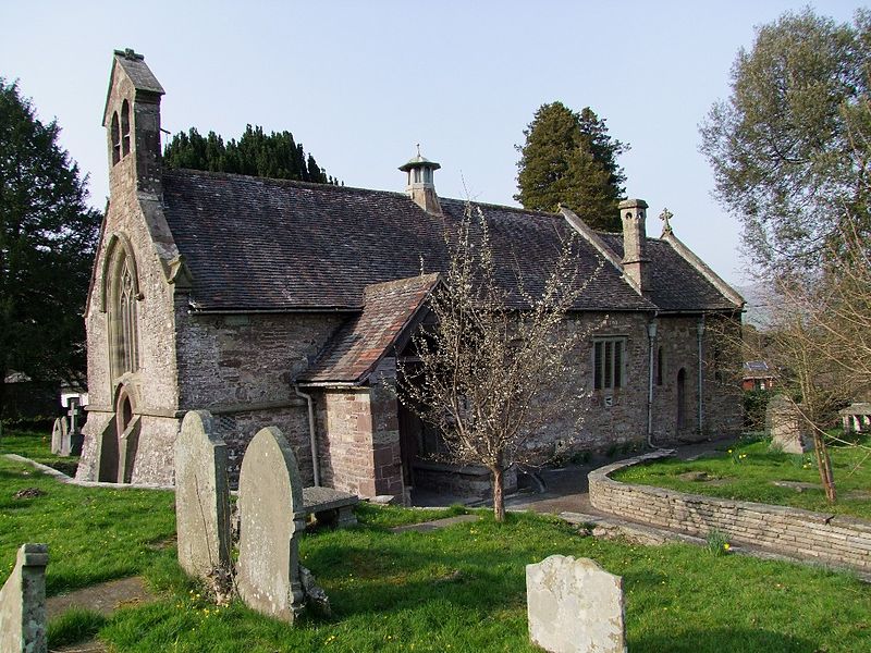
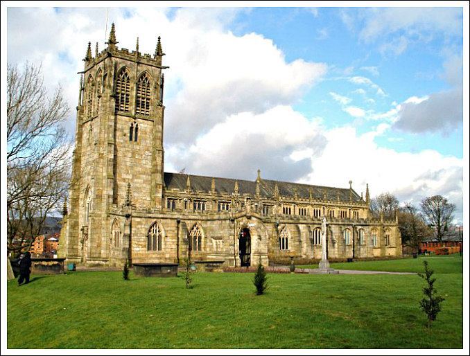
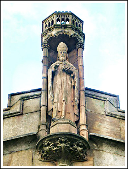
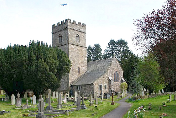
Llanfoist. Church of St Faith, Monmouthshire by Alf Beard (Creative Commons 2.0).

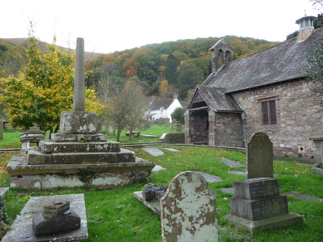
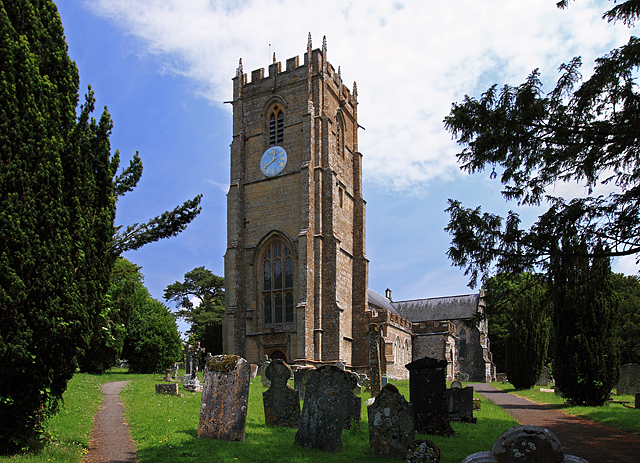
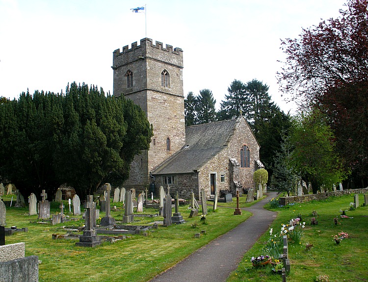
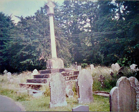
NGR:- SO 28588 13227. At the western edge of the village of Llanfoist near Abergavenny, in Monmouthshire, is the lovely little church of St Faith, a 19th century Gothic style building, but with some 13th century stonework remaining. Originally it was dedicated to St Ffwyst, a Welsh saint of the 6th Century, about whom next to nothing is known. She, or he, was also known as Foist, hence the name of the village, but the Latin name was probably Fausta. It is thought the saint was born on the Island of Anglesey. However the present dedication, perhaps through lack of any reliable information on St Ffwyst’s life, is to Saint Faith or Foy, a virgin and martyr under the Romans at Agen in France (304 AD), which was near the end of the reign of the Emperor Diocletion. The village name is sometimes given as Llanfoist Fawr, so could there be another Llanfoist or Llanffwyst somewhere else in Wales or on the Island of Anglesey? However, “it would seem that St Ffwyst was a priest of the monastic college of Seiriol, a saint who lived in Anglesey in the 6th century”, according to Chris Barber (1992). In the circular churchyard of St Faith’s there is the shaft and base of a medieval preaching cross, and an obelisk marks the grave of Crawshay Bailey Esquire, the 19th century ironmaster and industrialist of Nantyglo. St Faith’s Church is at the junction of Llanellen Road and the B4246 (Merthyr Road), just a little to the north of the Brecon & Abergavenny Canal.

Eiddil Eiddil (Thomas Evan Watkins) writing in 1834 tells us that: “The parish of Llanfoist extends from the banks of the Usk to the banks of the Torfaen, and is surrounded by the parishes of Abergavenny, Llanwenarth, Llanelly, Aberystruth, Trevethin, Llanelen, &c. There are some who believe the name (Llanfoist) to be derived from Llan and ffos, or Llan (Church) in the trench or marsh. Others (such as Willet in Stranger in Monmouthshire, 46) think it is Llanfoyle, whilst others still ask if there is no better derivation than either of the above names, and whether it cannot be derived from Llan and Faustus (Latin), that is to say, the lucky or prosperous church. Or it may be from Fausta, the daughter of Gwrtheyrn Gwrthenau by his first wife (Warrington, 63) and if so it may be inferred that this church was built at or about the beginning of the 6th century (Welsh saints, 86), although I am not aware that it has any register older than other churches. When historical researches are made (see William’s History of Monmouthshire, app. 194) we find the family of one William’s of Llanfoist descended from the lineage of Caradog Fraich Fras, Earl of Hereford, the Prince and owner of the fine territories between the Wye and the Severn, Lord of Dolorous Castle, and a Baron of the Order of the Round Table in the Time of King Arthur. And that one Gwgan ap Blethin ap Maynarch, Lord of Brecknock, married Gwenllian, the daughter and heiress of Phillip ap Gwys, Lord of Wiston, and I believe the Church was built in the time of Gwgan ap Blethin, as a token of regard for her grandfather (Viz. The Grandfather of Gwgan’s wife). It was easy to change Gwys into Ffwys, and corrupted more and more by others, doubling the F, so that scarcely anybody seeing the spelling of the word today by the Welsh and English would imagine that it had any connection with Gwys (Llanfoist !!).”

St Faith’s. Llanfoist Churchyard Cross by Jeremy Bolwell (Creative Commons 2.0).

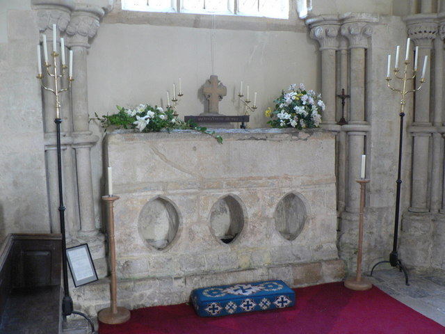
St Faith’s parish church stands in the shadow of the Blorenge Mountain, which is 1,841 feet high. In the churchyard there is a late Medieval preaching cross. The thin octagonal pillar, which possibly replaced an earlier shaft, stands to a height of just over 2 metres and tapers away towards the top. This is built into a chunky socket-stone, which is atop four ashlar-built steps; at the sides of the socket-stone there are curved stone stops. The steps are much older than the pillar; the largest step at ground level is cut-away at an angle – and the stepped arrangement is pyramidal in shape. Also in this churchyard is a tall granite obelisk marking the grave of the iron-master and industrialist of Nantyglo, Crawshay Bailey Esquire (1789 – 1872). “He owned ironworks and coal mines and was a railway pioneer in the Cynon Valley”, says Alun Roberts (2002). Some of the stained-glass windows inside the church are dedicated to the memory of Bailey, whose son greatly restored the church back in 1877 in memory of his father. Bailey Snr. had the Abergavenny town-hall clock built and also gave Bailey Park to the people of the town. There are yew trees in the churchyard which could well date back hundreds of years, although one that was 1,000 years old, sadly, came down in high winds in 2012.

Sources / References & Related Websites:-

Barber, Chris, The Seven Hills of Abergavenny, Blorenge Books, Abergavenny, Gwent, 1992.

Barber, Chris, Exploring Gwent, Regional Publications (Bristol) Limited, Clifton, Bristol and Abergavenny, Gwent, 1984.

Eiddil Ifor (Thomas Evan Watkins), Hanes Llanfoist, (Transcribed And Footnotes Added By Colonel J.A. Bradney, C.B.), First published 1998 in association with the Llanfoist & Distrct Historical Society, Blorenge Books, Llanfoist, Abergavenny, Gwent, in this edition Chris Barber.

Roberts, Alun, A Pocket Guide — Discovering Welsh Graves, University of Wales Press and The Western Mail, 2002.

Geograph Photo by Alf Beard:  St Faith Church, Llanfoist © Alf Beard cc-by-sa/2.0 :: Geograph Britain and Ireland

Geograph Photo by Jeremy Bolwell:  File:St Faiths, Llanfoist, Churchyard cross – geograph – 3199908.jpg – Wikipedia

Parish Church of St Faith, Llanfoist, Monmouthshire (britishlistedbuildings.co.uk)

St. Faith’s Churchyard Cross, Llanfoist, Llanfoist Fawr (Llan-ffwyst Fawr), Monmouthshire (Sir Fynwy) (ancientmonuments.uk)

Llanfoist (mongenes.org.uk)

| News | Abergavenny Chronicle

Vortigern ap Gwidol, High King of Britain (c.385 – d.) – Genealogy (geni.com)

Saint Faith – Wikipedia

Copyright © Ray Spencer, The Journal of Antiquities, 2021.


St Ebba’s Chapel, Ebb’s Nook, Beadnell, Northumberland

St Ebba’s Chapel near Beadnell (looking west). Photo Credit: Anne T.

NGR: NU 23964 28707.  The grassed-over scanty remains of St Ebba’s Chapel are situated on a narrow promontory known as Ebb’s Nook (Snook), which juts out into the North Sea, on the opposite side of Beadnell Harbour, near Seahouses. Northumberland. These grassy humps and lumps are all that remains of a 12th or 13th century chapel named after St Ebba or Æbba, a Northumbrian princess who died in 683 AD. There are also some earthworks surrounding the ruined chapel (E side) which are said to be those of a small pre-Conquest monastery possibly founded by St Æbba, the step-daughter of King Æthelfrith of Bernicia, who is ‘one and the same’ as St Abb, abbess of a monastery at Coldingham, near Eyemouth, on the East Berwickshire coast. She was also the sister of St Oswald, King and Martyr (d 642).

The chapel site can be reached by going through Beadnell village (north end): going (south) along Harbour Road and then Marl-borough Road. At the south end where the road bends to the southwest take the footpath (south) for a short while between the buildings, and then (east) along the promontory (Beadnell Point), with Little Rock in the distance; the chapel ruins are about half-way along this narrow, grassy promontory.

Nigel & Mary Kerr (1982) tell us that: “The situation of the small ruined chapel at Ebb’s Nook is all-important. It stands bleakly beside the North Sea, looking up the forlorn and storm-swept coast of Northumbria, and we may well wonder at the piety and faith which made men choose this of all places to build a chapel. There can be few more powerful examples of the juxtaposition of the spiritual and elemental than this small outpost of Christianity.

“The ruins of the chapel, originally a simple two-roomed structure of nave and chancel which was later extended by a western annexe, were uncovered in 1853. There is no certain date for the building, but the place name recording its associations with St Ebba, stepdaughter of Ethelfrith, king of Northumbria, suggests a site of ancient usage.

The first view of St Ebba’s Chapel near Beadnell. Photo credit: Anne T.

“St Ebba, whose feast day is 25th August, fled from Northumbria to Scotland when Edwin invaded the kingdom in 616. She later became a nun and was famed for her wisdom. She reputedly secured the release of St Wilfrid one occasion by telling Ecgfrith, the king who had imprisoned him, that his wife’s illness was a divine punishment for depriving the saint of his freedom: he was speedily released! Later, however, St Ebba was criticized for relaxed state of her community of nuns at Ely. Particular attention was drawn to the nuns’ weaving of fine clothes with which they sought to attract attentions of ‘strange men’. Despite this temporary lapse from grace, Ebba’s reputation for holiness continued after her death, and she was especially venerated during the 12th century in the north of England and south Scotland following the discovery of her relics.

“Perhaps, therefore, the little chapel on Ebb’s Nook is of the 12th century, and was constructed when her cult underwent a revival. But in lieu of direct evidence to the contrary, we will follow the confident assertion of the 19th-century excavators that this was the site of a chapel dedicated to her during the halcyon days of Northumbria in the 7th century.”

Northumberland National Park Guide (1990) tells us that:  “The small pile of grass-covered rubble near the point is the re-mains of Ebba’s Chapel, a 13th century structure excavated in 1853 after being buried for many years. Ebba was the sister of King Oswald; she may have been responsible for the building of a small chapel on this site in the 7th century. The stones and debris of the chapel have been colonised by thrift and scurvy-grass.”

St Ebba’s Chapel (north doorway and wall). Photo credit:  Anne T.

David Hugh Farmer (1982) has much more on St Ebba or Ebbe, saying she was: “first abbess of Coldingham (Berwickshire). Daughter of Ethelfrith, king of Northumbria, she fled to Scotland on his death in 616, when Edwin conquered Northumbria. Later she became a nun at Cold-ingham and subsequently abbess of this double monastery. In 672 Etheldreda was separated from her husband, King Egfrith, with the counsel of Wilfrid, and became a nun under Ebbe (who was her aunt) before founding her own monastery at Ely. In 681 Egfrith visited Cold-ingham with his second wife Ermenburga, who was then seized with some kind of sudden illness. Ebba, now famous for wisdom, interpreted this as a punishment for the imprisonment of Wilfrid, disobedience to Roman decisions in his favour, and the theft of his relics and reli-quaries by Ermenburga. Egfrith released Wilfrid; Ermenburga restored the relics and soon recovered.

“Not long afterwards, the aged Ebbe was warned by the priest Adomnan of the relaxed state of her community. The nuns were said to spend their time weaving fine clothes, to adorn themselves like brides or to attract the attention of strange men, while both monks and nuns alike neglected vigils and prayers. In spite of Adomnan’s threat of divine punishment, the community mended its ways only for a little while. A few years after Ebbe’s death, the monastery was burnt down (686). These failures of Ebbe’s community did not destroy her reputation for holiness. Her name was given to Ebchester and to St Abb’s Head, where the remains of a fort possibly indicate the site of her monastery. Interest revived in her during the 12th century, following the discovery of her relics in the late 11th. At this time, according to an account attributed to Reginald of Durham, she was known from York to Lanark. Calendar evidence for her feast comes from Durham, Aberdeen, and Winch-combe, while Durham and Coldingham shared her relics.  She is also the titular of a church and street in Oxford.  The present church at Coldingham (part of the priory founded by Durham) is more than a mile away from Ebbe’s monastery. Feast 25th August.”   

The 19th Century parish church in the centre of Beadnell village is also dedicated to the local saint, Ebba. There are three late 18th Century (restored) limekilns at Beadnell Harbour (east side).

Sources / References & Related Websites:-

Photos (above) are the © copyright of Anne T. Many thanks Anne for your help and kindness. Please see the Link:  https://www.megalithic.co.uk/article.php?sid=50082&m_distance=0.0

Farmer, David Hugh, The Oxford Dictionary of Saints, Oxford University Press, Oxford, 1982.

Kerr, Nigel & Mary, A Guide to Anglo-Saxon Sites, Granada Publishing Limited, St Alban’s, Hearts, 1982.

Northumberland National Park, Walks on the Northumberland Coast, Northumberland County Council National Park and Countryside Department, Eastburn, South Park, Hexham, 1990.

https://en.wikipedia.org/wiki/%C3%86bbe_of_Coldingham

https://en.wikipedia.org/wiki/Beadnell

https://historicengland.org.uk/listing/the-list/list-entry/1008563

https://www.pastscape.org.uk/hob.aspx?hob_id=8230

https://www.channel4.com/programmes/time-team/articles/series-19/st-ebbas-chapel-by-the-sea/453

More info here:  https://www.scribd.com/document/239530531/Time-Team-St-Ebba-s-Chapel-Beadell

© Ray Spencer, The Journal of Antiquities, 2020.


St Columba’s House, Kells, Co. Meath, Southern Ireland

Irish Grid Reference:- N 73908 75963. At the side of Church Lane, opposite the monastic site, in the town of Kells (Ceanannas Mór), Co. Meath, Southern Ireland, there is a curious little ecclesiastical building that is called ‘St Columba’s House’ or ‘the House of Columcille’ (Teach Naomh Cholumba), which dates back to the 9th-11th Centuries AD, although its sloping roof was probably rebuilt in more recent times. The chapel/oratory was probably built by one of the abbots. Traditionally, it was here that the famous illuminated gospels known as ‘The Book of Kells’ was written by a monk from St Columba’s Abbey in 800 AD and, the body of the Irish saint, may have been housed in this very building (or one before it) after being brought from Iona in Western Scotland in the late 9th Century. The monastic enclosure and graveyard on the other side of Church Lane has a 100 foot-high round-tower, and three sculptured Celtic high crosses, of the early Medieval period; and the Market Cross in the market square. Legend attributes the founding of the abbey at Kells to St Columcille (550 AD), although there has always been some uncertainty about that. 

St. Columba’s House, Kells, in Co. Meath, by Peter F. Anson

Peter F. Anson (1952) tells us about St. Columba’s House, saying that: “It is quite possible that in this curious little building with an upper chamber hidden away above the barrel vaulting of its roof, was written the famous Book of Kells, the great treasure of the library of Trinity College, Dublin. Who wrote this and illuminated this most perfect expression of Christian art which has survived the centuries of war and strife in Ireland ? Tradition has it that the artist was an unknown monk of the abbey of Kells, in Meath. Anyhow, whoever he was he must have been one of the greatest book illustrators and masters of penmanship the world has ever known, and for this reason I had always wanted to make a pilgrimage to Kells. When this marvelous work of art was being produced in what is now no more than a sleepy little country town, ‘London was a haunted Roman ruin on a hill with the brambles over London Wall and the camp fires of the East Angles shining on the marsh beyond the city which they were afraid to enter,’ writes Mr. H. V. Morton, ‘Paris was a desolation and the sun was setting over Rome.’ But Ireland, thanks to her isolation, remained a stronghold of learning and culture. What is left to-day of the ancient glories of Kells? There is this little building, known as St. Columba’s House, a dreary neglected churchyard containing some magnificent Celtic crosses, and that is all.”

The Wikipedia website says: ‘St. Columb’s House is today thought to mostly date from the 10th century. It is named after Columba (Colm Cille), whose relics it may once have housed. The roof was modified at a later date. The house was used by monks to say the Liturgy of the Hours, or possibly as a shrine church or burial place of an abbot. It once contained a large flat stone called “St Columb’s Bed”, possibly a grave slab. His relics were brought to Kells in 878, and moved to Skryne Church later before finally going to Downpatrick, according to Wikipedia. See Link, below.

Katharine Scherman (1981) says regarding the Book of Kells that: “Argument, often stormy, surrounds the history of the Book of Kells, there being strong claimants for its generation in Ireland, Iona, Lindisfarne or other insular foundations of Irish origin and mixed personnel. The answer will probably never be known, though some experts reason that evidence favours its inception at Iona in the late eighth century and subsequent removal to Kells, where it was completed in the first quarter of the ninth century.

“In 795 Iona was pillaged by Norse raiders; in 801-802 they came again and burned the monastery to the ground; returning in 806 they murdered sixty-eight monks….. In 807 the abbot, Cellach, with the remaining monks, moved to Ireland taking with them the bones and other relics of St Columba and whatever valuables they had managed to hide from the ravag-ers—among them, presumably, the unfinished manuscript. They went to the site of one of Columba’s monasteries at Kells, County Meath, and built there a new monastery, to be the headquarters of the league of Columban houses.

“Kells, being inland, was considered safe from the marauders, who, in the early years, limited their invasions to hit-and-run assaults on the monasteries immediately accessible by sea. But Kells was struck the year after its founding and its church destroyed. A new church was completed in 814 and the monastic village, probably fortified, succeeded in fending   off subsequent attackers. Undoubtedly, also, successive abbots paid tribute for the privilege of being left alone. At any rate, the monastery of Kells had years of peace in the early ninth century — time enough for the production of the great book. For the creation of such a complex, profound and subtle work of art is a luxury that presupposes a number of conditions: security from outward disturbance; wealth to afford the years of dedicated specialization of a corps of scribes and painters; a scholarly intimacy with the Christian thought of the time; and a large library of books from abroad, which, being rare, would take years to accumulate. The scriptorium at Kells, fortunate in its relative tranquillity, could meet these conditions and finish — though it was never absolutely finished — the work that had begun at Iona. But the monastery was not permanently inviolate. The Norse sacked it in 919, 950 and 969, and in the following century it was raided repeatedly by the Irish themselves. In 1170 it was burned to the ground by the Anglo-Normans at the instigation of their Irish ally, Diarmait Mac Murrough.

“Despite the brutal history of Kells, the manuscript survived almost intact. In 1006 it was stolen, and turned up two and a half months later buried “under a sod” with the gold of its wood-and-metal cover wrenched off. The inside pages were unscathed, though some missing leaves at the beginning and the end may have been torn off at this time.

Andrew Jones (2002) tells us that: “The first probable record of the existence of the Book of Kells is an account of the theft of ‘the great Gospel of Columkille, the chief relic of the western world’ from the great stone church of Kells in the year 1007. The book was found buried in the ground almost three months later, and presumably remained at Kells until it was brought to Dublin and presented to Trinity College by Henry Jones, Bishop of Meath, some time after the year 1661. It has been in the College Library ever since as its greatest treasure.”

Greenwood, Connolly, Hawkins & Wallis (1999) tell us a lot about the Kells monastic site, saying that: “The Round Tower in the churchyard is known to have been here before 1076, for in that year Murchadh Mac Flainn. who was claiming the High Kingship, was murdered within the tower. It’s a little under 100ft high, with five windows near the top, and missing only its roof.

“Near the tower is the South High Cross, the best and probably the oldest of the crosses at Kells, carved as ever with scenes from the Bible. Here you’ll see, on the south face, Adam and Eve and Cain and Abel; then the three children in the fiery furnace; then Daniel in the lions’ den. On the left arm of the wheel Abraham is about to sacrifice Isaac, and on the right are SS. Paul and Anthony in the desert; at the top is David with his harp and the miracle of the loaves and fishes. There are two other complete crosses in the churchyard, and the stem of a fourth (behind the church back-entrance door) with the inscription Oroit do Artgal, A prayer for Artgal. This has several identifiable panels. The near side shows the baptism of Christ, the marriage feast at Cana, David with his harp again, the presentation in the Temple, and others to worn to make out. On the other side are a self-conscious Adam and Eve, Noah’s Ark, and others hard to identify accurately. There are sculptured stones embedded in the walls of the bell tower.

“In the central market square there’s another fine high cross, discoloured by traffic fumes, said to have been placed here by Jonathan Swift. In 1798 it served as the gallows from which local rebels were hanged. Yet again, it is liberally festooned with fine stone carving. The base shows horsemen and animals in a battle scene; on the west face are the adoration of the Magi, the marriage at Cana and the miracle of the loaves and fishes, all surrounding the Crucifixion in the centre of the wheel; on the east are Christ in the tomb, Goliath, Adam and Eve, and Cain and Abel, with Daniel in the lions’ den occupying centre stage.”

Sources and related websites:-

Anson F., The Pilgrim’s Sketch Books — No. 4 — An Irish Pilgrimage, Burns Oates & Washbourne Ltd., London, 1932.

Greenwood, Margaret, Connolly, Mark, Hawkins, Hilda & Wallis, Geoff, Ireland — The Rough Guide, Rough Guides Ltd., London, 1999.

https://en.wikipedia.org/wiki/St._Columb%27s_House

Jones, Andrew, Every Pilgrim’s Guide To Celtic Britain And Ireland, Canterbury Press, Norwich, 2002.

Scherman, Katharine, The Flowering of Ireland — Saints, Scholars & Kings, Victor Gollancz Ltd., London, 1981.

https://en.wikipedia.org/wiki/St._Columb%27s_House#/media/File:St._Columb’s_House,_Kells_2018-07-24_

http://www.megalithicireland.com/Kells%20Monastery,%20Meath.html

http://irelandsholywells.blogspot.com/2013/06/saint-columbas-well-kells-county-meath.html

http://www.heritagetowns.com/kellslarge1.shtml

http://www.archaeologicalconsultancyservices.com/index.php/archaeological-consultancy-services-blog/47-archaeologist-from-acs-ireland-at-st-colmcilles-house-kells-co-meath

© Ray Spencer, The Journal of Antiquities, 2019.


St Columba’s Chapel at Skeabost, Isle Of Skye, Highland Region, Inner Hebrides

Ruined Chapel on St Columba’s Island, Skye, by Gordon Hatton (Geograph)

OS Grid Reference: NG 4177 4852. On the little island of Skeabost in the Snizort river, near Ken-saleyre, Isle of Skye, Highland Region, are the ruins of St Columba’s Chapel, an 11th century building, and there is a cemetery with  interesting 16th century gravestones. Near the ruined chapel is St Columba’s Rock from which the saint is said to have preached. The first chapel here at Eilean Chaluim Chille (St Columba’s Isle) on the Snizort river was founded in the 6th century by St Columba (521-97) whilst visiting Pictish settlements, and probably after founding his famous monastery at Iona (563 AD).  He also founded a chapel at Kilmuir a few miles to the north.  The larger ruined chapel at the eastern side of the island was known as ‘Skeabost Cathedral’. However, St Columba’s Chapel was partly destroyed in the early 16th century after which it fell into ruin – although the graveyard has been restored. The A850 from Portree to Uig runs just southwest of the island, which is  6 miles northwest of Portree. You can take the car ferry from Fort William or Mallaig to Armadale to reach Skye, or by car on the Skye Road Bridge from Kyle of Lochalsh to Kyleakin. A footbridge over the river Snizort gives the visitor or pilgrim access to this “holy” island.

There are two medieval chapels on the island, the 11th century chapel at the western side lies in ruins, whereas the other chapel ruin over to the east has a large rectangular enclosure surrounding it; this was probably the old parish church or Cathedral and of a 14th-15th century date? There is a third building at the southeast which was an enclosure.  The ruined chapel of St Columba, with its roughly built walls is now roofless, but its end gables still stand up to 11 feet high, and the building’s inner space measures 16 feet in length and 9 feet in width. The walls in between are 6-7 feet high. Only one window remains; and 13th century carved stonework can be seen higher up in the walls. There might have been a monastery here at some point, but more likely a bishop’s residence; the little island apparently being the seat of ‘the bishops of the Isles’. The larger chapel and its associated buildings in their heyday would have been the size of a small cathedral – hence the name Skeabost Cathedral. We know the first chapel here was established by St Columba (Columcille) after 563 AD, but the chapel that we see today was built either in the late 11th or the early 12th century. Columba was thought to be visiting Pictish settlements on Skye around this time and no doubt on a mission to Christianise them; the saint apparently preached from a large rock near his chapel.

Aerial view of St Columba’s Island by John Allan (Geograph)

Jonathan MacDonald tells us more about the place saying that: “On an island in the Snizort river is an ancient cemetery and site of Saint Columba’s Chapel, which is believed to have been built by Saint Columba during his visit to Skye and to have been the first Christian church on the island followed by the chapel at Eilean a’ Loch in Kilmuir. The biographer Adamson records how Saint Columba saw a vision before arriving in Skye of being greeted by an old man who would ask for baptism and on receiving it would die. The story goes on to tell how the Saint and his monks were met on landing near Skeabost by a group of men carrying an old and feeble man called Artbrannan who had heard of Columba’s message of Christianity and who was determined to be alive until he could meet the saint. Saint Columba duly took water and with the assistance of his monks baptized Artbrannan who, as soon as the sacred water touched his forehead, fell dead at the saint’s feet. His body was soon carried on a bier to the little island on the river and buried there by Columba and his men. It is said that this was the first Christian burial in Skye. Today, through the efforts of local people and organisations the old churchyard where countless local people including many chiefs of the Nicolson clan lie buried has been brought into a presentable appearance thus making it possible for people to visit this sacred and historical spot.”

Norman Newton (1992) tells us about St Columba’s monasticism on offshore islands. He says that: “Many traces of early Christian monasteries survive on our offshore islands, which were established by Columba and his contemporaries, for he was only one of many men who were spreading the Christian message. Undoubtedly, he was the most charismatic of the early English saints and, from the point of view of posterity, the most fortunate, because it was one of his successors at Iona, the abbot Adomnan, whose Life of St Columba, written in the 680s, is distinguished from all the other lives of early saints by its racy style and fascinating detail of the people and places of Columba’s time. Adomnan was supremely skilled in public relations, for he purveyed a heady mixture of fact and the supernatural which is compelling reading even in these skeptical times.”

There are some interesting graves in the ‘now tidy’ churchyard on St Columba’s Isle, but those in St Columba’s Chapel which was put in to use as a Mortuary Chapel, are of the clan chiefs MacNicol (MhicNeacail) or Nicolson, 28 of whom apparently lie here in what has been called ‘The Nicolson’s Aisle’. Most of the graveslabs, some of them having carved effigies, are probably of the 16th century. There are said to be gravestones here that date from earlier times maybe the 11th century? And there are are other clan graves out in the cemetery and in the second ruined chapel although these are probably not of the clan Mac Nicol.

Sources and related websites:

MacDonald, Jonathan, Discovering Skye – A Handbook of the Island’s History and Legend, J. MacDonald, Upper Duntulm, Kilmuir, Skye.

Newton, Norman, The Shell Guide To The Islands Of Britain, David & Charles, Newton Abbot, Devon, 1992.

The AA, Illustrated Road Book Of Scotland, The Automobile Association, 1963.

Photo (top) by Gordon Hatton:  https://www.geograph.org.uk/photo/3956554

Photo (middle) by John Allan:   https://www.geograph.org.uk/photo/4844681

https://en.wikipedia.org/wiki/Snizort_Cathedral

https://www.britainexpress.com/scotland/Skye/skeabost-chapel.htm

http://www.theskyeguide.com/see-and-do-mainmenu-35/42-interesting-places/110-st-columbas-isle

https://canmore.org.uk/site/11282/skye-skeabost-island

https://www.scorrybreac.org/st-columbas-island.html#

https://www.clanmacnicol.org/saint-columba

http://www.academia.edu/20262543/From_cathedral_of_the_Isles_to_obscurity_-_the_archaeology_and_history_of_Skeabost_Island_Snizort

https://her.highland.gov.uk/monument/MHG5135

© Ray Spencer, The Journal of Antiquities, 2018.


3 Comments

St Robert’s Cave-Chapel And Holy Well, Knaresborough, North Yorkshire

St Robert’s Cave by Storye book (Wikimedia Commons).

OS Grid Reference: SE 36083 56059. In a secluded wooded area near Grimbald Bridge between Abbey Road and the River Nidd at Knaresborough, North Yorkshire, is St Robert’s Cave & Holy Cross Chapel. Nearby, another chapel, but a 15th century wayside chapel and shrine, hewn out of the rock, which is today dedicated to Our Lady of The Crag. This particular chapel is not how-ever associated with St Robert. About 470m to the north is St Robert’s holy well, a healing spring resorted to by the faithful in times past. Robert Flower (1160-1218) was a hermit who spent many years here – more especially his latter years – but also at a number of other monastic sites across Yorkshire. He was said to have performed some miracles and devoted much of his time to the poor, though he was never canonised by the Church.  You can reach St Robert’s Cave from the newer bridge on Wetherby Road (B 6164). Go down the steps onto Abbey Road and a bit further south beside the river is the cave. The medieval Chapel of ‘Our Lady of the Crag’ is ½ a mile to the west at the other end of Abbey Road. St Robert’s Well was located on Monkswell Park Road about a ¼ of a mile north of town.

David Hugh Farmer (1982) says that St Robert was: “The son of an important townsman of York and became a cleric early in life. As a subdeacon he was a novice at the Cistercian abbey of Newminster, but stayed only a few months. He then chose to live as a herm at Knaresborough in a cave where another hermit, also in residence, was a knight in hiding from Richard I, on whose death (1199) he returned to his wife. Robert continued there for some years, until a wealthy widow offered him a cell and chapel at Rudfarlington, near by. A year later this hermitage was destroyed by bandits, so Robert lived at Spofforth under the church wall for a few months, then at Hedley near Tadcaster, where he found the monks to easy-going, before returning to Rudfarlington. Here he had four servants and kept livestock, but was soon in trouble with William de Stuteville, constable of Knaresborough Castle, for harbouring thieves and outlaws. The charge may have been true, for Robert was well known for charity to the destitute. The hermitage was destroyed by William; Robert returned to his cave at Knaresborough, where he lived for the rest of his life.

Farmer goes on to say of St Robert: “His benefactors included King John who gave him forty acres of land in 1216, which he eventually accepted for the poor  and so refused to pay tithes on it. William de Stuteville also gave him land and cows. Robert had a companion called Yves, who  remained with him for the rest of his life.

Farmer also adds that: “Robert’s death, like much of his life, was controversial. Cistercian monks from Fountains tried unsuccessfully to aggregate him to their Order on his death-bed and, after his death on 24th September, to bury his body in their church. But he refused the first and foiled the second by arranging for his burial at the chapel beside his cave. Later the Trinitarian house at Knaresborough acquired the hermitage: papal records for 1252 offered  an indulgence for ‘Building the monastery of St. Robert at Gnaresbur, where the saint’s body is buried’. This document followed his translation, but preceded any official process of canonization, for which a book of Lives and prayers was prepared. Official canonization never took place, but implicit approval was given to the cult. The chapel became a place of pilgri-mage, where oil flowed from the tomb. Matthew Paris regarded Edmund of Canterbury, Elizabeth of Hungary and Robert of Knaresborough as outstanding saints of the early 13th century.”

Sign at St Robert’s  Cave by Caruso 308 (Wikipedia)

St Robert’s Cave on Abbey Road, with its connecting chambers and the grotto-like inner chapel, were carved out of the solid Limestone cliff beside the river Nidd. It’s thought the saint himself enlarged the chapel and hermitage which has a stone altar, stone seat, two alcoves, medieval carved cross and more recent graffiti; building this structure must have taken a considerable amount of both energy and time. The chapel was dedicated in honour of the Holy Cross and maybe also St Giles? Pilgrims visited the hermit-saint knowing him to be a miracle worker, and even some eminent local people were known to seek his good council. However, the cave and chapel were frequently flooded by the river Nidd and for long periods remained uninhabited and cut off – this more so in recent times. After the death of St Robert in 1218 his body lay in a tomb that was located in the cave-chapel. There is a church dedicated to him at Knaresborough and another at Pannall, north Yorkshire. Morley church, Derby-shire, has some very nice stained-glass windows depicting the Life of St Robert of Knaresborough. His feast-day is 24th September.

There used to be a holy well named for St Robert 470m to the north of the saint’s cave (at SE 3629 5650), but today that holy spot is the Monkswell Business Park, Manse Lane. However, the last vestiges of the said well/spring can still be seen although today it is a ‘wishing well’ into which locals throw coins! Robert Charles Hope (1893) said of this well that: “A short distance above Grimbald’s Bridge, in a field called Halykeld Sykes, on the north side of the river Nidd, is “”St Robert’s Well.”” There is also a chapel of St. Robert of Knaresborough, which was confirmed by charter to the Brethren of the Order of the Holy Trinity at Knaresborough by Richard, Earl of Cornwall.” Another holy well, said to be named after St Robert, can still be seen just to the southeast of Levisham, north Yorkshire.

Our Lady of The Crag, Knaresborough. (Drawing)

About ½ a mile to the west, at the other end of Abbey Road, is the medieval chapel of  ‘Our-Lady-of-the Crag’, which has sometimes mistakenly been called St Robert’s Chapel, but this folly-like structure was built 200 years after the saint. The chapel, with its tiny inner shrine, was carved out of the sandstone rock-face in c1408 by a local mason by the name of John, whose son was almost killed in a rock fall. John prayed to Our Lady for a miracle. His son survived, and to thank Our Lady for the miracle he built the Chapel in thanks. The inside of the chapel is very tiny but there is an altar and a lovely modern statue of Mary. It has a carved vaulted ceiling with bosses and gargoyles. Church services do still occasionally take place at the chapel and groups of pilgrims come on visits (see the St Mary of Knaresborough website, below, for more informa-tion). By the chapel’s entrance and ‘standing guard’ is an 18th century carved statue of a very life-like knight in armour holding his sword. The chapel is Grade I Listed.

Our Lady Of The Crag Chapel.

Headley & Meulenkamp (1999) add with regard to this chapel and saying that: “………it is a wayside shrine with beautiful Gothic decoration, immediately above it is Fort Montague, an 18th century folly.” They say of Knaresborough that: “it resembles parts of Derbyshire, not least because of the large number of hermits caves.” Fisher & Pennington (1953) say that: “It was originally a wayside chapel, founded at the beginning of the fifteenth century. It won its unenviable place in the annals of notoriety when Eugene Aram hid in it the body of his victim. Aram was convicted of murder and executed in 1759 many years after his crime, which was given a romantic interest quite undeser-ved by a novel of Bulwer Lytton. The figure is of a knight drawing his sword.”  

Sources and related websites:-

Farmer, David Hugh, The Oxford Dictionary of Saints, Oxford University Press, 1982.

Fisher, Graham & Pennington, John, Historic Britain, Odhams Books, Feltham, Middlesex, 1953.

Headley, Gwyn & Meulenkamp, Wim, Follies Grottoes And Garden Buildings, Aurum Press Ltd., London, 1999.

Hope, Robert Charles, The Legendary Lore Of The Holy Wells Of England, Forgotten Books, 2012 (originally published 1893)

https://commons.wikimedia.org/wiki/File:St_Roberts_Cave_008

https://en.wikipedia.org/wiki/Robert_of_Knaresborough

http://www.stmarysknaresborough.org/shrine.html

https://www.visitharrogate.co.uk/things-to-do/st-roberts-cave-p1203201

http://www.crsbi.ac.uk/site/1970/

http://www.halikeld.f9.co.uk/holywells/north/robert1.htm

http://www.megalithic.co.uk/article.php?sid=26391

© Ray Spencer, The Journal Of Antiquities, 2017.


St Peter’s Church, Prestbury, Cheshire

St Peter’s Church   (R. A. Riseley, 1952).

   OS Grid Reference: SJ 90082 76935. The 13th and 14th century grey sandstone parish church of St Peter at Prestbury, Cheshire, is located at the southwest side of the village, close by the A538 road (the village road), and just opposite The Bridge Hotel. The village is located some 4 miles to the southeast of Wilmslow. The River Bollin flows near the church. There was probably a late Saxon church on this site, or close by, in the 11th century. There is the obvious evidence with regard to that early church in the churchyard where there’s a very well-put-together monument made-up of two large fragments of Saxon crosses, which has some very nice, almost Celtic-like, carvings. Also in the churchyard a 12th century Norman chapel with a carved doorway that has some outstandingly beautiful sculptural work: above the doorway is a tympanum with “Christ in Majesty” and above that seven carved figures that are now sadly defaced.

   The parish church has some medieval features including an Early English three-light lancet window (1220-30) at the north side of the chancel and a 13th century piscina with carved head in the south aisle, while the 13th century font was recut in the 19th century and has carved heads of monks from St Werburgh’s Abbey. In the north aisle is a 14th century figure of St Nicholas. There is a nice oak rood-screen of 1787. The crenellated church tower is of 1480. Also of interest some late medieval carved (incised) coffin slabs. The earliest coffin slab is built onto the north wall of the chancel and has a foliated calvary cross and a Latin inscription to Reginald Legh, Esquire, son of Robert Legh, Knight, foremerly Lord of Adlington. He built the church tower and porch. Reginald died in 1482. Apparently there was a priory hereabouts in the 14th century and, in the century following, there was a monastic hospice (Spittal House), which in more recent times became a farm. After the Norman Conquest the manor and church came into the possession of the Earl of Chester and, by 1153 Hugh Kyvelioc, Earl of Chester, had given the same manor and church to the Abbey of St Werburgh at Chester. Another interesting slab in the north wall of the chancel shows Sir Edward Warren of Poynton, who is represented in full armour; around the border is a Latin inscription: “Here lyeth the body of Edward Warren of Poynton, Knight, which departed from this transitory life the 12th day of October, in the year of our Lord God, 1558. Whose soul God pardon. Amen.”

Saxon Cross in St Peter’s Churchyard by R. A. Riseley.

   The Anglo-Saxon cross in the churchyard is actually two sections of different crosses that have been delicately placed together to form a T-shaped ancient monument; the carvings looking much more Celtic in design than Saxon. This may be due to the close proximity of Prestbury to the Welsh border and, we know that that border was as far east as Chester and Warrington back in the so-called Dark Ages, and so the Celtic influence was stronger. The cross fragments were discovered about 1841 when restoration work on the chancel was taking place; the sandstone fragments were embedded in the masonry. Originally the carved fragments were presumed to date from the 8th century, but today they are considered to be from the 10th or 11th century. It is richly carved all over with interlacing, interlinking and key-pattern designs. At the bottom there is a strange creature with a large, open mouth and several tails and a possible human figure, while there is a second human figure in the centre of the top T-shaped section. All-in-all a very beautiful piece of sculptured stonework, be it Celtic or Anglo-Saxon? Also in the churchyard a Grade II listed sundial dating from 1672.

Norman Chapel at St Peter’s Church, Prestbury, by R. A. Riseley, 1955.

   At the southeast side of the parish church stands the 12th century Norman Chapel. According to the booklet ‘Prestbury and its Ancient Church’ (1952): “The building which stands close to the present Church and which is generally known as the “Norman Chapel”, was probably built on the site of the more ancient Saxon edifice. It has a beautiful Norman doorway, a fine specimen of its kind. Over the doors is a tympanum representing “Christ in Majesty,” a subject which occurs in 21 other Norman tympana in England. Above on the corbel table are seven figures, now much defaced, which are of great interest, being unique in Christendom. Their interpretation seems to be as follows: The central figure represents God the Father holding the law in His left hand typified by an open book, and the Gospel in the right hand as fore-shadowed by the cross; conjointly justice and mercy are portrayed. The figure to the right with the animal (the Norman method of drawing a lamb) seems to stand for Christ, the Lamb of God , seated at the right hand of the Father. The figure to the left, having a resemblance to a bird, typifies the Holy Ghost in form of a dove. Collectively these three figures stand for the Trinity. St Peter with the key is shown in the sixth figure. To this saint the church was dedicated as is its successor at the present day. Figure two represents the monarch who reigned when the oratory was built, and this is almost certainly Richard I, Coeur de Lion, he being the first of the Norman kings to bear the budded scepter surmounted by a plain cross as here shown. The brings the date of the oratory within the year of his coronation, 1190, and that of his death, 1199.

   “The warrior with battle axe, figure one, and priest with staff, figure seven, represent the military and ecclesiastical government of the county palatine. The figures then may be, when taken together, interpreted as follows: “”In the name of the Blessed Trinity, this church, dedicated to St. Peter, was built by the abbot and monks of St Werburgh in the reign of Richard I, when Randle Blundeville was Early of Chester.”” 

   The Parish church of St Peter is a Grade I listed building and the Norman chapel is a Grade II listed building.

Sources & Related Websites:-

Bottomley, Frank, The Church Explorer’s Guide, Kaye & Ward Ltd., London, 1978.

Rogers, Harold, W (forward by the vicar), Prestbury and its Ancient Church, Macclesfield Press Ltd., 1958? (Drawings by R. A. Riseley).

The AA, The Illustrated Road Book Of England & Wales, The Automobile Association, London, 1961.

Churchyard Cross, Prestbury, Cheshire

https://en.wikipedia.org/wiki/St_Peter%27s_Church,_Prestbury

https://historicengland.org.uk/listing/the-list/list-entry/1221919

http://www.crsbi.ac.uk/site/1197/

                                                    © Ray Spencer, The Journal Of Antiquities, 2017.


2 Comments

Tintagel Head Celtic Monastery, Cornwall

Map of Tintagel Island in Cornwall.

Map of Tintagel Island in Cornwall.

   OS Grid Reference: SX 05003 89064. On the rocky, windlashed headland of Tintagel-Head, in Corn-wall, near the ruins of Tintagel Castle which was built in c 1145, are the scant foundations of what was considered to be a Celtic monastery, dating from the beginning of the 6th century AD. This was probably a high-status Dark Age monastery with royal connections. There are also the walls of a 12th century chapel of St Julitta which is attached to the monastic buildings. It has always been assumed that the monastery here on Tintagel Head was founded in 500 AD by St Juliot, Julitta, or Julianta, a princess who hailed from south Wales, and might be one and the same as St Uletta. Tintagel Castle has long had “romantic” associations with King Arthur and Merlin the Magician. Today the monastic remains lie on Tintagel Island, which is all but cut-off from the rest of the headland where the castle ruins are situated. There is limited access from the castle to Tintagel Island through a deep chasm in the headlands via a footpath and bridge, but its very precarious and great care “should” be taken, especially if weather conditions are against you.

   The monastic site here at the south side of Tintagel Island, with its rectangular-shaped buildings all joined together, was excavated in the 1920s and 30s by C. A. Raleagh Radford (1900-1999) – at which time it was thought to be a high status Celtic monastery, but more recently a few historians have opted for the possibility that it might have been a trading centre due, perhaps, to the large amounts of pottery (known as Tintagel Pottery) found at the site, says Geoffrey Ashe ‘A Guidebook to Arthurian Britain’. Another large building (site E) that was a part of the monastery lies beneath a garden, while other little clusters of buildings (sites B.C. and F) lie to the S and SE of the main monastic site, which is known as site A. These clusters of buildings were probably the monastery’s farm and stables. By the 9th century it seems the monastery here at Tintagel was abandoned, its buildings left to go back to nature and the mists of time, but to be re-invigorated again in the 1920s by an archaeological dig! 

   There is a lot of very good field information on the Celtic monastery at Tintagel in the work ‘The Quest for Arthur’s Britain’, edited by Geoffrey Ash. It says that with regard to excavations on the island: “These excavations showed that the headland of Tintagel had been the site of an extensive Celtic monastery. Four different phases identified in one of the buildings indicated a long period of occupation. Imported pottery from the east Mediterranean established an initial date in the fifth or early sixth century. A silver penny of King Alfred (871-99)—the latest artifact antedating the castle—may represent no more than the loss by a pilgrim to a deserted oratory which was no longer the centre of a living community. Pottery of the twelfth century and later, though relatively common on this site, was never found in the layers associated with the monastery.

   “The Celtic monastery of Tintagel was bounded on the landward side by an earthen bank, now crowned by the thirteenth-century curtain, and by a broad, flat-bottomed ditch. The upper part of the existing bank is a twelfth-century heightening, but the base, some 30 feet across and 8 feet high, dates from the fifth or sixth century. Like its medieval successor, the monastic bank ran from the edge of the scarp overlooking the eastern valley to within a short  distance of the protruding boss of rock, leaving the same narrow entry. Early texts often speak of the monastic vallum, a term indicating the enclosure which fenced in the cashel or settlement occupied by the community. It seems always to have been a physical barrier, an earthen bank, a rampart of turf or a hedge. But it also had a spiritual meaning, separating the city of God from the world outside.

   “Within the enclosure the monastery consisted of groups of buildings, each with its special function. Eight such groups were located, of which six were explored and planned; the other two had been too far destroyed by the medieval castle. Two further sites were noted in folds of the cliff, and others probably await identification.

Plan of Celtic monastery at Tintagel, Cornwall.

Plan of Celtic monastery at Tintagel, Cornwall.

   “The first and largest site examined lay on the eastern edge of the plateau; it was centred on the twelfth-century chapel. The Celtic site consisted of a long range of buildings facing east on to a court which was bounded on the far side by the cliff, here forming the edge of the plateau. The range was approached from the south by a path running along the edge of the plateau; this is now reached by a modern zigzag approach rising up from the inner ward of the castle. The original way is likely to have been along the plateau, which has here been destroyed by the encroachment of the sea. At the south end of the range of buildings, a small square room thrust forward from the general line, together with the stub of a wall, suggest a gate with a lodge providing access to the court. With the court, a much-ruined stretch of walling immediately south of the later chapel is probably part of an older oratory. Beside it is the base of a square block of masonry, a tomb shrine or leacht. These tomb shrines are a normal feature in Celtic cemeteries; they housed the relics of saints or founders.

   “On the far side of the chapel a number of graves have been discovered. The oratory with the tomb of the saint would be the primary objective of visiting pilgrims. In its immediate vicinity one would expect to find the various buildings catering for their needs. There would be a treasury containing other relics, perhaps possessions of the saint. There would also be a sacristy, where the vessels needed for the service of the oratory would be stored. A guesthouse for the refreshment of pilgrims might also be found in this area, together with rooms needed by those members of the community charged with the care both of the pilgrims and of the lay community, of which the pastoral care was the responsibility of the monastery.

   “On this basis, it may tentatively be suggested that the southern end of the range, with a large central hall and smaller rooms grouped on one side and to the back, represents the guesthouse. The central part, now appearing as a single room, has been much damaged by the later chapel. Originally it may well have been subdivided, and here, in the vicinity of the oratory, one might expect the treasury and sacristy. This would leave the smaller rooms at the north end for the needs of those members of the community whose duties were with the lay world. This range had a long history. Four distinct building phases could be recognized. Normally the phases indicated adaption, while retaining the main structure of older date. Even so, a life of some three centuries is not likely to be too long for the existence of this community, and it could well have been in being for a far longer period.”

   And what about the founder/foundress of the Celtic monastery on Tintagel Head. Who was St Juliot or Julitta? The thinking is that the founder was St Uletta (Ilid). She was, according to legend, one of the many daughters of King Brychan Brycheaniog and was the founder of the first church at Llanilid, Mid-Glamorgan, in Wales, and is commemorated there with St Curig. In c 500 AD she went with other members of her family to Cornwall. We know that she was close, spiritually, to her sister St Morwenna and her brother St Nectan. It seems, however, that in Cornwall her original name was St Juliana (Iludiana) and over time the name became Juliot and Julitta; and soon after her arrival in Cornwall she established the monastic community at Tintagel.

   But St Juliot has been much confused with an early 4th century Christian martyr called St Julitta, who was commemorated with her three-year-old son St Cyricus in the west country. Their cultus was brought to Cornwall in the Middle Ages. St Juliot, however, is perhaps the patroness of Luxulyan church, Cornwall, with a feastday on the sunday nearest 29th June, according to David Farmer ‘Oxford Dictionary Of Saints’.  In Cornwall St Juliot (Julitta) is sometimes referred to as a “martyr” due to confusion, again, with the 4th century saint of the same name. St Juliot is also commemorated at Lanteglos-by-Camelford, Cornwall, where a holy well is named for her. And St Juliot in the Valency Valley, north-east Cornwall, is named after the saint. A few historians have suggested that St Juliot was, in fact, a male saint! St Julitta’s feastday at Llanilid church in Mid Glamorgan, Wales, is given as 30th June.

Sources and related websites:

Ashe, Geoffrey,  A Guidebook to Arthurian Britain, Longman Group Limited, London, 1980.

Farmer, David, Oxford Dictionary Of Saints, Oxford University Press, 2004.

AD 500 – Tintagel

https://en.wikipedia.org/wiki/Saint_Ilid

https://en.wikipedia.org/wiki/St_Juliot

http://www.thisisnorthcornwall.co.uk/king_arthur.html

Jones, Sally, Legends of Cornwall, Bossiney Books, St Teath, Bodmin, Cornwall, 1980. 

Spencer, Ray, A Guide to the Saints Of Wales and the West Country, Llanerch Enterprises, Felinfach, Lampeter, Dyfed, 1991.

The Quest for Arthur’s Britain, (Edited by Geoffrey Ashe), Paladin Frogmore, St Albans, Herts, 1976.

Westwood, Jennifer, Gothick Cornwall, Shire Publications Ltd., Princess Risborough, Bucks, 1992.

                                                                 © Ray Spencer, The Journal Of Antiquities, 2017.


St Chad’s Church, Rochdale, Greater Manchester

St Chad's Church at Rochdale, Greater Manchester.

St Chad’s Church at Rochdale, Greater Manchester.

    OS grid reference: SD 8964 1313. St Chad’s parish church stands upon a lofty ridge overlooking the River Roch and the town of Rochdale, Greater Manchester. The church is a very imposing edifice standing high above the equally imposing Victorian town-hall and its famous clock tower. There was a church here in either the late Saxon period, or more likely just after the Norman conquest – the mid 11th to early 12th centuries – although that is open to question. There is a well-known legend that says there were problems with the siting of the first church which was being built on lower ground on the other side of the river, and that it had to be re-sited to the higher position that we see it today. The church can be reached from opposite the Town Hall carpark and by climbing the steep 124 steps up to Sparrow Hill.

    Author Dennis Ball in his interesting book ‘Lancashire Pastimes’, says that: “A Saxon thane, Gamel, Lord of Rochdale, decided to build a church to St Chad on the banks of the river Roche. The foundations were dug and all the materials taken to the site. All the materials mysteriously disappeared and reappeared at the summit of the steep hill on the opposite side of the river. Gamel was very annoyed and blamed his workmen. He made them take all the materials back to the original site. This took the whole of the next day. That night they were again moved back to the top of the hill. But this time the culprits were seen by some of the workmen. They were goblins.”

    Another, more lengthier interpretation of the legend, from the 19th century is given by J. Harland & T. T. Wilkinson in ‘Lancashire Legends’, which is published in ‘The Secret Country’ by Janet & Colin Bord. They say: “Towards the close of the reign of William the Conqueror, Gamel, the Saxon thane, Lord of Recedham or Rochdale, being left in the quiet possession of his lands and privileges, was ‘minded, for the fear of God and the salvation of his immortal soul, to build a chapel unto St Chadde’, nigh to the banks of the Rache or Roach. According to Mr Roby, in his ‘Traditions’, a place was set apart on the north bank of the river, in a low and sheltered spot now called ‘The Newgate’. Piles of timber and huge stones were gathered in profusion; the foundations were laid; stakes having been driven, and several courses of rubble stone  laid ready to receive the grouting or cement. In one night, the whole mass was conveyed, without the loss of a single stone, to the summit of a steep hill on the opposite bank, and apparently without any visible signs of the mode of removal. The Saxon thane was greatly incensed at what he supposed to be a trick of some of his own vassals, and threatened punishment; to obviate which, a number of the villeins and bordarii with great difficulty and labour con-veyed the building materials back to the site for the church; but again were they all removed in the night to the top of the hill. Gamel having learned the truth, sought counsel from Holy Church, and it was thereon resolved that the chapel should be built on the hill-top, as the unknown persons would not permit it to be erected on the site originally selected. This explains the chapel or church of St Chadde, still standing on a hill so high that one hundred and twenty-four steps were cut to accomplish the ascent, and enable the good people to go to prayers.”

Statue of St Chad on Rochdale Parish church.

St Chad’s statue, Rochdale Parish church.

    St Chad to whom Rochdale parish church is dedicated was a 7th century northern churchman who became abbot of Lastingham in Yorkshire, and for a while he was bishop of York until St Wilfrid returned from France. Later, he was made bishop of the Mercians at Lichfield. He died in 672 AD and his feast-day is held on 2nd March (Colin Waters ‘A Dictionary Of Saints Days, Fasts, Feasts And Festivals’). The town of Chadderton near Rochdale is probably named after St Chad.

    There are no antiquities of great age within St Chad’s, although the Tudor pews are of some notable interest and parts of the church tower are ‘thought’ to date back to the late Saxon age, or more likely the early Norman period. The statue of St Chad high up on the outer south wall is particularly fine. The Lancashire poet John Collier (Tim Bobbin) 1708-86 is buried in the churchyard.

Sources:

Ball, Dennis, Lancashire Pastimes, Burnedge Press Limited, Royton, Greater Manchester, 1987.

Bord, Janet & Colin, The Secret Country, Granada Publishing Limited, St Albans, Herts, 1980.

The Automobile Association, The Illustrated Road Book Of England & Wales, London WC2, 1961.

Waters, Colin, A Dictionary Of Saints Days, Fasts, Feasts And Festivals, Countryside Books, Newbury, Berks, 2003.


1 Comment

St Candida’s Church, Whitchurch Canonicorum, Dorset

Shrine of St Candida at Whitchurch Canonicorum. (Photo credit: Wikipedia)

Shrine of St Candida at Whitchurch Canonicorum. (Photo credit: Wikipedia)

Os grid reference: SY 3967 5432. At the north-side of Whitchurch Canonicorum village, in Marshwood Vale, along Lower Street stands St Candida’s Church (St Candida and Holy Cross), an ancient parish church on an equally ancient site, probably Saxon. The building houses the quite rare 13th century shrine of  a Saxon saint who was apparently martyred hereabouts by Vikings; the church then became a place of pilgrimage during the Middle Ages. St Candida is also known as St Whyte, St Wite, St Wita and St Gwen, though very little is actually known about her, and the date of her death not known with any real certainty – although it was, according to legend, somewhere between the 7th-9th centuries AD. The church tower of St Candida’s has some carved stones built into it which depict the martyrdom of the saint. The village of Whitchurch Canonicorum lies in the far south-west of Dorset – a few miles north of the A35 on country lanes – some 6 miles north-east of Lyme Regis and 2 miles north-east of Charmouth.

Within the parish church stands a rare 13th century stone shrine with three large oval-shaped apertures and, inside this there is a lead reliquary which is said to contain the bones of a local Saxon saint called Candida or Wite who was martyred at nearby Charmouth, probably at the beginning of the 8th century AD or, possibly in the 9th century? Some historians ‘consider’ her to be a saint from south Wales called Gwen Tebrion, but this seems most unlikely as St Gwen lived at an earlier date, the 6th century, but she shares the same feast-day 1st June.  Gwen means ‘White’ in the Welsh language form. The assumption was that King Athelstan gave the ‘so-called’ relics of St Gwen to the church at Whitchurch Canonicorum back in the 10th century AD.

A reference in the Reader’s Digest book ‘Folklore Myths and Legends of Britain’ says of the apertures in the medieval shrine “pilgrims thrust diseased limbs or bandages in the hope of miraculous cures”. Indeed numerous miracles of healing the sick and infirm have been recorded here over the centuries. An early miracle recorded at the shrine was the restoration of sight (Rodney Castleden, 1986).

In an article by Rodney Castleden ‘Saints, Shrines & Miracles’ for ‘Exploring The Supernatural’ magazine in 1986 we are given some interesting information about St Candida’s tomb [shrine]. The author says: “At the turn of the century a crack appeared in the stonework of St Candida’s tomb. It was then possible to examine the leaden reliquary inside… which carried the inscription HIC REQUEST RELIQE SCE WITE (Here lie the remains of Saint Wita? Wita was an alternative name for Candida. The lead box was opened up and inside were found the bones of a small woman who was about forty years old at the time of her death”. Castleden goes on to say that: “Very little is known about St Candida. Indeed, it may be her obscurity that ensured that she attracted no attention at the time of the Dissolution. All that we know about her, apart from the evidence of her shrine, rests on local tradition, which may or may not be reliable. The local tradition says that St Wita, or Candida, was a Saxon woman killed by the Danes on one of their raids when they landed at Charmouth. Part of this tradition is preserved in carvings on the church tower; they show a Viking axe and a Viking longship, the agencies of Candida’s death”.

Parish Church of St Candida at Whitchurch Canonicorum (Photo credit: Wikipedia)

Parish Church of St Candida at Whitchurch Canonicorum (Photo credit: Wikipedia)

The parish church of St Candida and Holy Cross stands on a Saxon foundation, but the present-day building is architecturally Early English (late Norman) to Perpendicular – 12th to 14th century. The font is Norman and the pulpit Jacobean, and it is noted for its nave arcades and tombs, according to The Illustrated AA Road Book of England & Wales. Authors Jones & Tricker ‘County Guide To English Churches’ say that: St Candida’s is “nearly all EE. The south doorway is however Norman and the S porch Perp. The arcades are EE with stiff-leaf foliage and trumpet-scallop capitals. The fine tower has eight pinnacles and is Perp. Norman font with intersecting arches, 16th C stalls (French) and Jac pulpit”.

It is of interest here to mention that just 1 mile to the south of Whitchurch is the village of Morecombelake and a healing well dedicated to St Candida (Wite). The well has long been able to cure eye troubles. Indeed author Rodney Castleden says: “Dorset children still call the pale blue flowers of the periwinkle ‘St Candida’s Eyes’, which again links the saint with eyesight. The well and its magic properties seem likely to form part of a much older tradition, from long before the Christian era”.

Sources

Castleden, Rodney., Saints, Shrines & Miracles, The Supernatural Magazine, November 1986.

http://en.wikipedia.org/wiki/Church_of_St_Candida_and_Holy_Cross

Jones, Lawrence E. & Tricker, Roy., County Guide To English Churches, Countryside Books, Newbury, Berks, 1992.

Pepin, David., Discovering Shrines And Holy Places, Shire Publications Ltd., Princes Risborough, Aylesbury, Bucks, 1980.

Reader’s Digest., Folklore Myths & Legends of Britain, (Second Edition), The Reader’s Digest Association Limited, London, 1977.

The AA, The Illustrated Road Book of England & Wales, (Second Post – War Edition), The Automobile Association, London WC2, 1962. 


2 Comments

St Teilo’s Church, Llantilio Pertholey, Monmouthshire (Sir Fynwy)

St Teilo's Church, Llantilio Pertholey.

St Teilo’s Church, Llantilio Pertholey, Monmouthshire.

Os grid ref: SO 3114 1632. St Teilo’s Church at Llantilio Pertholey about 1 mile north of Abergavenny (Y Fenny), Monmouthshire, stands in a secluded hollow just off the Old Hereford road, in a lovely, peaceful setting within what looks to be a partly circular churchyard. The church is largerly medieval but there are many different periods built into the structure which can be a bit confusing, if not daunting. At the back of the church there is an ancient yew tree that is said to be 1,200 years old, so there ‘may’ have been a place of worship here in the 8th century? And there is a medieval churchyard cross (south-side) which is now a war memorial.

According to ‘The Legend’ an unidentified holy man called Bevan came here with some companions and established a cell. Bevan was a follower of the renowned Welsh churchman, St Teilo (Theliau), who is said, according to legend, to have died at his monastery of Llandeilo-Fawr, Carmarthenshire, in 560 AD. Teilo had earlier been bishop of Llandaff, succeeding St Dubricius (545). The name Pertholey (Bertholey) and Bertholiau is thought to refer to “a defiled gate” or entrance, but other than that the meaning is uncertain. So why was it defiled? Could it refer to “martyrs”? We know that Bevan was buried here, but he seems not to have suffered martyrdom. Fred Hando in his work ‘Hando’s Gwent’ 1987 refers to ‘The Book Of Llandaff’ for information as to the beginnings of this place; he also says: Pertholey is Porth Halauc – a polluted entrance.

The hamlet of Llantilio Pertholey is just north of Mardy on the Old Hereford road, while Abergavenny is 1 mile south, and the more recent A465 road to Hereford is just a little east of the church. At the edge of the churchyard the river Gavenny makes its way toward the town, and then to Llanfoist. St Teilo’s stands in the shadow of Skirrid Fawr, holy mountain to the local people. A couple of legends, or myths, are associated with the Skirrid – probably in connection with the part of the hill that has slipped away due to an earthquake at the time of Christ’s crucifixion, or it was caused when the giant, Jack o’ Kent tried to jump from the Sugar Loaf to the Skirrid – but missed his footing. There are also remains of an ancient Roman Catholic chapel of St Michael on the top of the hill, now just a few stones in a little grassy hollow.

Another View Of St Teilo's Church, Llantilio Pertholey.

Another View Of St Teilo’s Church, Llantilio Pertholey.

In the 15th century porch there is an ancient holy water stoup (sadly it is broken) and a wooden alms-box (1704). The interior is spacious but everywhere seems to be ‘put to good use.’ Probably the oldest part of the church is the north tower with its 14th century entrance to the stairway, though there may be some earlier, 13th century masonry in the nave, according to Mike Salter in his work ‘The Old Parish Churches Of Gwent, Glamorgan & Gower’ 1991. The east and south arches are of 1350-1400. It is worth pointing out that some of the arches are ‘all out of true’, seem to lean inwards and are irregular, while the two chantry chapels (north and east) date from the 15th and 16th centuries respectively, the 15th century north chapel (Triley Chapel) has a depressed arch, a timber two-bay arcade, a crude stone altar with consecration crosses was originally a stile, a recess in the wall that may have once housed a tomb and some medieval tiles in the floor [church leaflet]. The south chantry chapel (Wernddu Chapel) was added in the 16th century. In the nave the west window dates from 1729. The east chapel (Neville Chapel) is particularly nice as it has graceful oak arches supported by stout oak columns carved with flowers and cable pattern, according to the historian Fred Hando ‘Hando’s Gwent’ 1987.

The octagonal font has a full size bowl and its lid is recent; the angles at the base of the font have carved fleur de lys, according to the church leaflet. I think the most interesting part of this church is the “squint” or hagioscope which afforded a good view of the altar. Canon E.T. Davies in his book ‘A Guide To The Churches of Gwent’ 1977, says that: “It is around the chancel arch that the visitor should looks for squints or hagioscopes, especially at the end of a north or south aisle. These apertures enable those sitting or, more probably standing, in the aisles, a view of the high altar; they are not leper squints.” The piscina in the wall to the right retains some of its original colouring [church leaflet]. So, all in all a very nice interior.

Cross/war memorial in St Teilo's churchyard.

Cross/war memorial in St Teilo’s churchyard.

Outside in the churchyard (south side) stands a beautiful war memorial on a very large chamfered base – the monument is modern but the base is medieval. The churchyard cross used to stand on the base but was destroyed in the 1640s. Close-by, to the west an ancient yew tree that is hundreds of years old and could, therefore, date back to the Dark Ages (the 6th century) when Iddon, son of King Ynyr, gave this piece of land to Llandaff and St Teilo on which to build a church. Above the porch there is a nice shield-shaped sundial. Over on the south-side of the Skirrid (Ross Road) stands the church of St David at Llanddewi Skirrid, while a few miles over to the north-west is the gorgeous little church of Bettws -these two buildings are cared for, and ministered by, the incumbant of St Teilo’s.

Sources:

Salter, Mike., The Old Parish Churches Of Gwent, Glamorgan & Gower, Folly Publications, Malvern, 1991.

Davies, E. T. Canon., A Guide To The Ancient Churches Of Gwent, The Griffin Press, Pontypool, Gwent, 1977.

Hando, Fred., Hando’s Gwent, Blorenge Books, Abergavenny, Gwent, 1987.

The church leaflet (a very useful little guide).

Barber, Chris., Mysterious Wales, Paladin (Grafton Books), London W1X, 1987.


Hope Churchyard Cross, Derbyshire

Churchyard Cross, Hope, Derbyshire (Photo credit: Geograph)

Churchyard Cross, Hope, Derbyshire (Photo credit: Ashley Dace (Geograph).

OS grid reference: SK1721 8347. At the southeast side of the Derbyshire village of Hope stands the 14th-century church of St Peter and the Hope Churchyard Cross, a late 9th-century Saxon cross-shaft. There is also a medieval cross in the churchyard. The church is located on Station road at the east side of the village close by Pinder Road and, just a short distance to the east the river Noe flows into Peakshole Water. And 1 mile further east in The Hope Valley at Brough the scant earthworks of a Roman fort can be seen. The village of Castleton is 2 miles west on the A6187, Bamford is 3 miles to the northeast, and Buxton is 6 miles to the southwest on the A6 road.

This 6-foot 6-inch sandstone cross-slab stands at the south side of the church and is now set into a more modern square base. Said to date from the time of King Alfred, it was found in two pieces after being hidden away in the wall of a nearby school-house until 1858, having lain there for safety since the Civil War. It is richly carved albeit a little weather-worn. All four sides have carvings in separate panels, the best side being the east which has three panels; at the top there is knotwork, while in the middle two figures are holding up a large staff (or a cross), the lower panel having two interlaced rings surrounded by foliage. The west face is also excellent. Again there are three panels, the top shows a figure holding the cross above his shoulders, the central segmental-headed panel has two saints embracing, while the bottom one has three double concentric rings with double cords crossing ‘diagonally’ and inter-linking over the rings. The north face has just two panels with snakes biting each other (top) and the bottom having four-cord plait design with interlacing; there is interlacing composed of figure of eight knots on the south face. Sadly the cross-head is long gone. Close to this is The Eccles Cross, dating from the Middle Ages.

Near the north door there is a medieval calvary on five octagonal steps with a pillar sundial on top of an eight-sided base. This base has a square-shaped hole which could have accommodated an earlier, Saxon cross, although the whole thing is more akin to a market or wayside cross? Inside the church there are two nicely carved medieval grave slabs (in the chancel) with crosses and various symbols of outdoor life, namely hunting horns and arrows suggesting that these belonged to two officials of the Royal Forest of the Peak. These grave slabs were made in the 13th century and came from the building prior to the present church. On the north wall there are a number of “ugly” gargoyles, reflecting our pagan past, two of which may be the horned god of the Celts, Cernunos. According to the author David Clarke in his book ‘Ghosts & Legends of the Peak District, 1991, St Peters “is the oldest recorded Christian place of worship in the northern Peak District, and in Saxon times it was the focus of one of the largest parishes in England, stretching from the Derwent woodlands in the north to Buxton, Tideswell and the Padley gorge.”

About a mile to the east at Brough, near Bradwell, in the Hope Valley are the earthworks of the Roman fort of ANAVIO. But there is little to see now apart from some low, grassy banks. Two Roman roads ran from the fort, one going to Buxton, the other to Melandra Castle near Glossop and Templeborough, near Rotherham.

Sources:

Geograph:  http://www.geograph.org.uk/photo/2368735

Photo:  © Copyright Ashley Dace and licensed for reuse under this Creative Commons Licence.

Sharpe, Neville. T., Crosses Of The Peak District, Landmark Publishing Limited, Ashbourne, Derbyshire, 2002.

Clarke, David., Ghosts & Legends of the Peak District, Jarrold Publishing, Norwich, 1991.

Bunting, Richard., Anglo-Saxon and Viking Derbyshire, J. H. Hall & Sons Limited, Derby.

Copyright © Ray Spencer, The Journal of Antiquities, 2014 (updated 2023).


Stydd Chapel, Ribchester, Lancashire

St Saviour's Chapel at Stydd, Ribchester.

St Saviour’s Chapel at Stydd, Ribchester.

OS grid reference: SD 6538 3597. About ½ a mile to the east of Ribchester village, just after the Ribchester Arms Inn, turn off the B6245 (Blackburn road) and head up Stydd Lane (past the 18th century Stydd Almshouses) which eventually becomes a dirt track, and where soon you reach the isolated and ancient little Stydd Chapel, a simple rectangular-shaped building looking a bit like a barn, dating back to the mid 12th century and dedicated to St Saviour. And how pleasant the building is, surrounded on one side by a tiny grassy enclosure which was in use as a graveyard until 1879; and some old and new farm buildings scattered around it at the back. There are a number of interesting architectural features in the building and, equally some interesting old grave-slabs. The river Ribble runs close by and Dutton is bit further along the Blackburn road, while Longridge is 2 miles to the north-west and Whalley is 4 miles due east on the A59 road via Copster Green and Billington.

In her book Lancashire Countrygoer, 1964, authoress Jessica Lofthouse says of Stydd Chapel: “Six centuries ago the Knights Hospitallers of St. John of Jerusalem owned an estate at The Stede, a small “monastery” complete with chapel, dormitory, refectory and cloisters. They were crusading monks, rarely at home until the last fighting men had returned from the Holy Places. In 1338 — when it was considered it no longer served any useful purpose — it was dissolved.” The earliest documented evidence is probably the deeds (undated) of the mid 12th century, then later in 1292 another, clearer more acceptable document saying that “the Knights Hospitallers of St John aquired the land from one Adam of St Saviour at Dutton”. Author Ron Freethy in his book Exploring Villages, 1985, refers to St Saviours as a “Crusader church” and goes on to say that these Hospitallers whom took a major part in the crusades over in the Holy Land also brought back ‘healing’ herbal plants and says: “for the Knights of St John were not only good fighters but skilful healers and herbalists. Many of the plants they cultivated still grow well near Styd, and a careful look around the church yard will reveal plants such as toothwort, used to cure toothache, and willow trees from which they stripped the bark to cure headache”.

It was either in 1136 or 1150 when the Knights Hospitallers arrived at Ribchester to establish their chapel and monastic hospice for pilgrims, though it seems there had already been some kind of religious building on the site at the back where Stydd Manor farm now stands, perhaps an early Christian church or, more likely a Roman temple dedicated to the god Mithras, because Archaeological excavations here in 1912 came upon another building that ‘appeared’ to pre-date the present chapel, and could well be of a 4th century date, according to local authors John & Phillip Dixon in their book Journeys Through Brigantia (Volume 9) The Ribble Valley, 1993. A stone dedicated to Mithras was discovered inside the Roman fort at Ribchester – being used as a floor tile in a Romano-British building there. Stydd Manor farm still has some stones from the hospice or monastic farm incorporated into it’s walls.

The Early English porch (south door) was added to the chapel in the 13th century and has an oak door studded with nails and covered in old graffiti, while inside the building is rather “primitive” or bare to say the least with it’s stone-flagged floor, but there are also some interesting antiquities to be seen, despite that. Inside, the south door is quite beautiful with some exceptional carvings including concave keel mouldings and capitals with Corinthian floriated designs, dating from around 1200. But best of all are the north doorway and windows. On the exterior of the late Norman north doorway (now blocked up) there is what is called dog-toothed zig-zag carving (from between 1160-1190) and two round-headed windows. The octagonal font is made of gritstone and dates from the early 1500s and is interesting because it has carvings of sheilds and sacred heraldic symbols on all it’s sides, while the oak screen is of the late 17th century; and the piscina or water stoup built into the south wall of the chancel is medieval – maybe even late Norman, and has a trefoil stone head but it’s water bowl has gone. High up in the west wall there is another blocked-up doorway – this probably once lead to a wooden gallery and linked-up with another building, now long gone.

Gravestone of St Margaret Clitheroe at Stydd Chapel.

Gravestone of St Margaret Clitheroe at Stydd Chapel.

In the sanctuary at the back of the chapel we have some large recumbant grave-slabs. The one that is badly broken at the bottom with the plain incised cross is “said” to be that of the Roman Catholic martyr St Margaret Clitheroe (1556-86) who suffered for her faith at York and was canonised as one of the English Martyrs in 1970. She could, perhaps, have been related to the Clitheroe family who lived in these parts during the 14th century, though we don’t know this with any “real” certainty, but why would the gravestone of a Yorkshire martyr be here at Stydd? At the side of this stands a coffin tomb of unknown date. The other interesting gravestone which is now broken across the middle has a lovely floriated design. Buried here beneath this stone are the Knight Sir Adam de Cliderow and his wife Lady Alice Cliderow (1350). Outside in the old graveyard there is a medieval cross-base – it’s stump having disappeared. This is said to have come from Duddel Hill on the moors a few miles to the north of Stydd. Church services are still held ‘occassionaly’ at the Stydd Chapel and visitors, rather than pilgrims, come here now to look at the building.

Sources:

Lofthouse, Jessica., Lancashire Countrygoer, Robert Hale Limited, London, 1964.

Dixon, John & Phillip., Journeys Through Brigantia (Volume Nine) The Ribble Valley, Aussteiger Publications, Barnoldswick, 1993.

Freethy, Ron., Exploring Villages with Ron Freethy, Countryside Publications, Brinscall, Chorley, Lancashire, 1985.

Church Guide (Booklet), The Church of St. Saviour, Stydd. 2004. (In conjunction with St Wilfrid’s Church, Ribchester).


Church of St Mael and St Sulien, Corwen, Denbighshire, Wales

Cross-Shaft in Corwen churchyard (Jeff Buck - Geograph)

Cross-Shaft in Corwen churchyard (Jeff Buck – Geograph)

OS grid reference SJ 0788 4341. Near the centre of the little town of Corwen, in the Dee Valley, beside Chapel street and London road (A5) – stands the parish church of St Mael and St Sulien, a building that dates back to the 12th-15th centuries, although there was an earlier, Norman church on this site as far back as the 12th century and, probably even further back to the 6th century AD. The church houses a small collection of antiquities that are well worth viewing. In the porch there is a strange-shaped stone in the wall that could pre-date the church, and above the priest’s door a flat stone bearing an incised cross; also an ancient font and medieval tomb. Out in the churchyard a Celtic cross-shaft stands upon a pre-historic stone base that has what are ‘considered to be’ cup markings. The town of Llangollen is 11 miles to the east on the A5, while the historic town of Ruthin lies some 10 miles to the north along the winding A494 road.

The first church, whether that be in the 6th century or the 11th century, according to legend, it was built where a large and ancient pointed stone stood – as it could not be built eleswhere because a “voice” from a higher place (not of this world) had warned against it. At some stage this large pointed stone 6 feet in length was incorporated into the wall of the north porch, but it is difficult to see it today as the porch has been plastered over. Local people called it the ‘Thumb Stone’ or ‘Pointed Stone’. It could well pre-date the church and be pre-historic in date. It is also known in Welsh as ‘Carreg y big yn y fach rhewllyd’ or “the pointed stone in the icy corner.” On the outer south wall of the church, above the priest’s door, a large flat stone lintel has an incised Celtic-style consecration cross carved onto it, possibly dating from the early Christian period. Local people believed that this mark was actually the impression made by Owain Glyndwr’s dagger when he hurled it at the church in a fit of rage from Pen-y-Pigyn hill overlooking the town; and ever since it has been referred to as ‘Glyndwr’s Dagger Stone’. Glyndwr (1349-c.1445) led the Welsh in a revolt against King Henry IV. A few others have suggested the dagger or spear was thrown by Owain, King of Gwynedd, from Caer Drewyn in the 12th century? Also in the church a Norman font of circa 1100, a dug-out wooden chest and a beautifully carved 14th century memorial tomb to Iorweth Sulien, a previous rector of the church.

In the round-shaped churchyard near the porch stands a slender Celtic preaching cross-shaft, dating from between the 9th to 12th centuries, which sadly, has a broken head. It is made of granite and is 7-foot (2.2) metres high. There is interlacing on the broken cross-head (capital) and some other decoration on the shaft, including a small incised Latin cross. The cross stands on a large, circular (octagonal) base stone that is 5 foot 3 inches in diameter and 1 foot in depth; this stone is ‘thought’ to date back to the Bronze Age and has what are considered to be 7 depressions or cup-marks (is this the only cup-marked stone in Wales), quite possibly, and could it have come from a pre-historic burial site that once stood in the churchyard or close by? where there was originally an alignment of stones.

The dedicatees of the church St Mael and St Sulien were, according to the Legend, Christian missionaries who came to Wales from Brittany in 516 AD along with St Cadfan, St Padarn, St Cynllo and St Tydecho. However, it is quite plausible St Mael never existed at all because Corwen church now adopts St Michael the Archangel as it’s second patron, in a way dropping St Mael, although the name is very similar. But St Sulien is remembered in north Wales – indeed he was the cousin of St David. Sulien or Silian went on to establish a number of churches in northern Wales, including Llansilin and Llandyssil in Powys and Capel-St-Silin in Cardiganshire, but over time he has become confused with another saint called Tysilio. In later life we are told: Sulien settled at Luxulyan in Cornwall but returned to Brittany and died there. He has a feast day on the 13th May. At Tyn Llan near Llansilin, Powys, there is a holy well named for him (Ffynnon Silin) and there is a St Sulien’s holy well (Ffynnon Sulien) near Rug Chapel – west of Corwen on the A494 road.

Sources:

Barber, Chris., More Mysterious Wales, Paladin (Grafton Books), London, 1987.

Gregory, Donald., Country Churchyards In Wales, Gwasg Carreg Gwalch, Capel Garmon, Llanrwst, Gwynedd, 1991.

Jones, Francis., The Holy Wells Of Wales., University of Wales Press, Cardiff, 1992.

Spencer, Ray., Historic Places In Wales – An Exploration of the Fascinating and Mysterious (unpublished manuscript), Nelson, Lancashire, 1991.

Spencer, Ray., A Guide to the Saints Of Wales and the West Country, Llanerch Publishers, Felinfach, Lampeter, Dyfed, 1991.

http://www.cpat.demon.co.uk/projects/longer/churches/denbigh/72143.htm

http://wellhopper.wordpress.com/2012/02/16/ffynnon-sulien-corwen/

Copyright © Ray Spencer, The Journal of Antiquities, 2013 (updated 2024).


3 Comments

Kilpeck Church, Herefordshire

SO4449 3051. The little Herefordshire village of Kilpeck is 2 miles east of the A465 Hereford to Abergavenny road at Wormbridge and 7 miles south-west of Hereford. It is noted for its outstandingly beautiful 12th century Norman church with many carvings that are greatly influenced by the Celtic, Norse and also medieval (Romanesque) periods in history. It is now dedicated to St Mary and St David, its original dedication was to St Pedic or Pedoric, hence the name Kilpeck. This 6th century Celtic saint, a follower of St David or St Dubricius (Dyfrig), had a cell here and later a Saxon church sprang from that in the 7th or 8th century. At the back of the church there is a round-shaped churchyard indicating that this was a sacred site before the coming of the Celtic, Christian church.

In 1140-1150 the building that we see now was built over the Saxon building  – although as is always the case some restoration has taken place in more recent times. By 1143 the church of Kilpeck was placed under the care of the Benedictine abbey of Gloucester giving it a monastic status; the monks came and built a small cell here soon afterwards. All the carvings that we see here are from the late 12th century and were probably all done by the Hereford school of stonemasons. The church survived being abandoned in the 14th century, the Reformation of the 16th century and the puritans of the 17th century, in fact, the place looks as if it has only just been built, especially as it is always kept well whitewashed and in a most excellent state of repair.

English: Kilpeck church The church is dedicate...

Kilpeck church (Photo credit: Wikipedia)

Kilpeck church is renowned for its very beautifully carved Norman south door, carved chancel-arch, nave and vaulted apse. Part of the nave (NE corner) may date from the 11th century. The font is Norman but the holy water stoup could be pre-Conquest; this is carved with animal heads and a pair of hands holding two heads. But it is the many carvings on the outside of the church that do it justice for there are so many to see. The exterior of the south door has double columns and a richly carved tympanum over the top. A vast array of carvings can be seen on the doorway including snakes, human heads, foliage, birds, dragons, warriors, medallions and a green man. The tympanum shows what is almost certainly the Tree of Life.

On the exterior walls running along the corbel table below the roof there are many strange, comical and often quite ugly carvings. These include two men fighting, a dog and rabbit, the lamb of God and cross of Jesus, a vulgar sheela-na-gig displaying genitalia, two dragons fighting, green men, a warrior entwined, human heads, a cat and dog and, a pig. But there are others too. A walk around the church is well worth it. Close to the church are the earthworks of a 11th-13th century Norman motte and bailey castle.

Kilpeck Church (South Door)

Kilpeck Church, sheela-na-gig


St Trillo’s Chapel, Rhos-On-Sea, Caernarvonshire (Gwynedd)

SH8413 8113. The tiny medieval chapel-cum-baptistry of St Trillo stands just off Marine Drive, close to the promenade, at Rhos-On-Sea, some 2 miles north-west of Colwyn Bay. Also called Capel St Trillo, the tiny building stands in a quiet area beside the seashore in what has been a hallowed spot for many hundreds of years. Within the chapel is a holy well (Ffynnon Drillo) which has been a place where pilgrims have come in the hope of a miraculous cure. An earlier Celtic chapel or a hermit’s cell stood here previous to the present structure, a cell where the 6th century saint, Trillo, had once lived.

St Trillo’s Chapel, Caernarvonshire

St Trillo’s chapel is a tiny, plain stone-built roofed building measuring 11 feet by 8 feet inside with walls that are 2 foot thick and low vaulting inside. The building is so tiny that only a small number of people are allowed in at any one time, the door is also quite narrow and there is only one tiny stained-glass window which shows St Elian another local Celtic saint. But it is open every day for prayer. The holy well is located beneath the altar but it is often covered by a metal grid – though this can be removed for access to the water inside a square-shaped basin. Even today the water from the well is used for baptisms. The monks of Aberconwy abbey looked after the chapel and holy well from roughly 1283 until the dissolution in 1538 at which time the monks had relocated to Maenan in the Conwy Valley, near Llanwrst.

What we know about St Trillo is that in the 6th century AD he came to Wales from Brittany and worked as a missionary along the north Wales coast as far as Anglesey where there is another church dedicated to him at Llandrygarn. He was the son of King Ithael Hael and his brothers were called Tegai and Twrog – both saints in their own right. St Trillo lived at his humble little cell at Rhos-On-Sea between the years 570-590 AD. He was buried on the holy island of Bardsey.