Clava Cairns (Stones of Clava), Inverness-shire, Scotland.
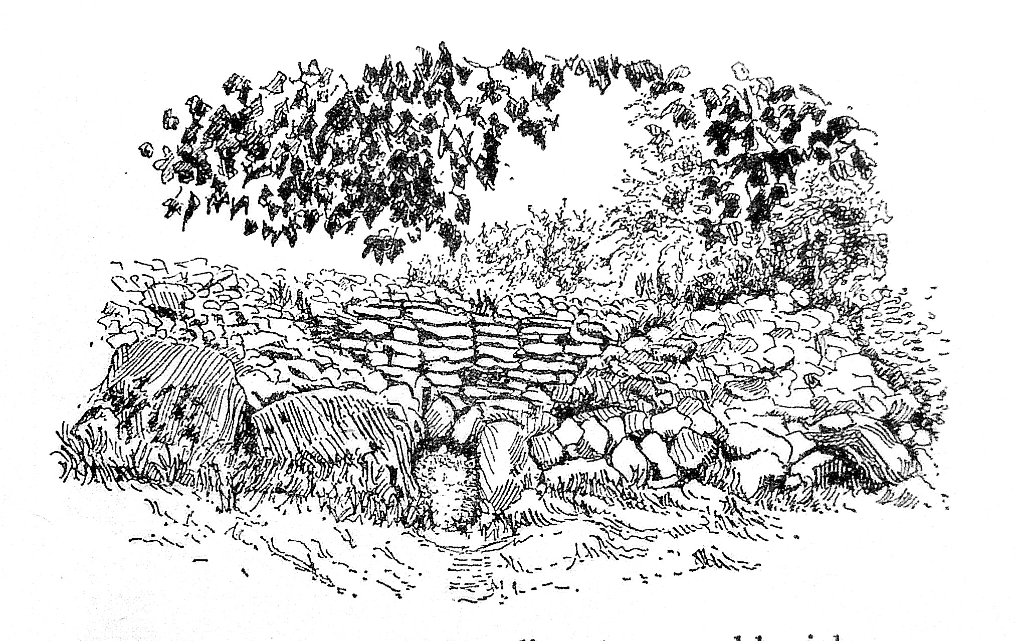
NGR: NH 75737 44432. About 1 mile south-east of the Culloden battle site, across the river Nairn at Balnuaran of Clava, Highland region, Scotland, is a group of prehistoric monuments. The Clava Cairns (also known as Stones of Clava) date from the late Neolithic to early Bronze Age. The group or complex consists of three-chambered burial cairns, the central one of the ring type. They are essentially large, circular piles of stones. Around the edges of the cairns are some upright stones forming a kerb, some of the stones having been replaced and a few went missing altogether. At least one of the cairns at Balnuaran, 7½ miles to the east of In-verness, was excavated in the late 1820s at which time some fragmentary bits of a funerary urn were found, but nothing seems to have been found in the other two cairns when they were excavated in the late 1850s. Some cup marks are visible in one of the passage walls of Cairn II. Visitors can walk along the passageways into the circular centres of the cairns. There is an outer circle of standing stones surrounding the middle ring cairn.
The site is in the care and management of Historic Environment (Scotland). Clava Cairns’ location is beside a country lane to the east of the B851 and B9006 roads on the south side of the river Nairn; the lane itself cuts through the stone circle. A car parking area is provided for visitors to this ancient cemetery.
Timothy Darvill writing in 1988 tells us: “The late Neolithic tombs at Clava, partly restored, stand in a line on a north-east to south-west axis. All three are round in plan and each is surrounded by a stone circle. The central tomb is of the ring-cairn type. Constructed of massive boulders edged with a kerb of even larger stones, the cairn was heaped up to a height of about 1.2m. The central area is edged by flat stones, and during excavation in 1857 was found to contain cremated human bone. The two outer tombs are typical of the type of monuments generally known as Clava Cairns and as such form part of a widespread late Neolithic tradition of tomb-building in northern and western Britain which also includes the entrance graves of west Penwith….. and the Scilly Isles. Both the outer tombs at Clava have circular cairns edged with large boulders. In the centre of each is a circular chamber approached by a passage from the southwest, an axis that may be significant as it coincides with the midwinter sunset. Large upright stones formed the walls of the chambers and passages, while the roofs were originally corbelled. Human bone, some cremated, has been found in both of the chambers.”
The Illustrated HMSO Guide to Ancient Monuments of Scotland (1959) discusses Sepulchral Circles and tells us: “A very specialized variety, confined to the coasts of the Beauly Firth and the valleys of the Nairn and Spey, is best represented by the group at Clava under the Ministry’s guardianship. Monuments of this class are generally marked “Stone Circles” on the Ordnance Survey Maps, and some in fact appear today as three concentric rings of great stones. In reality, even these are just the most stubborn remnants of chambered cairns of what Childe once termed the Beauly class. The innermost ring constituted the foundation for a chamber’s wall; the next bounded and supported the cairn that covered it. Only the outer ring originally consisted of free-standing uprights. In the cases mentioned the smaller boulders forming the cairn have been carted away.
“The inner and middle rings in fact consist of massive rounded boulders set close together. The outermost alone comprises tall monoliths. Stones in one or more rings are quite often adorned with cup marks. No cairn of the Clava (or Beauly) class has yielded any relics to provide archaeologists with a clue as to the relative age of its erection. They are classed as “Bronze Age” here in view of their relation on the one hand to the Boyne tombs of Eire, on the other to the Recumbent Stone Circles of Aber-deenshire. But of course the same term could be applied just as well to Maes Howe and kindred Orcadian tombs. Nevertheless, apart from a group in Strathspey, near Aviemore, Clava Cairns do seem to lie along a Bronze Age trade route well defined by the distribution of characteristic weapons. The Recumbent Stone Circles exhibit a complementary distribution along the eastern continuation of the same route.
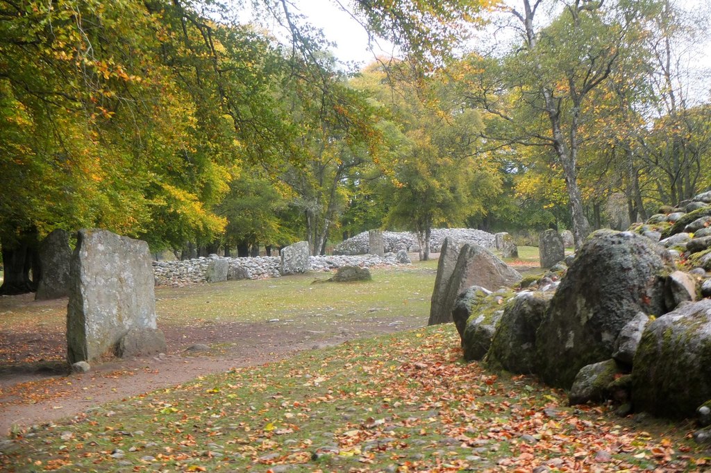
Clava Cairn site. Photo by Jim Barton (Geograph/Creative Commons).
“The Cairns of Clava stand on the flood plain of the Nairn in the narrow gorge immediately below the battlefield of Culloden Moor. They were opened in 1828, when sherds of a rough clay urn, now lost, were recovered from one. Cairn I, the most westerly, is surrounded by a circle of 11 upright monoliths; four of the stones had fallen and were replaced last century, perhaps rather out of position; there was probably once a 12th stone. The cairn, with an overall diameter of 53 feet, is surrounded by a kerb of large boulders, interrupted by a gap opposite the tallest uprights. This is the entrance to a passage, bordered by similar boulders, 2 feet wide and once 4½ feet high. It leads to a chamber some 12½ feet in diameter. The ring of large boulders on edge that frames it supports courses of rubble masonry oversailing one another inwards. This masonry must originally have been carried up to form a corbelled dome over the whole space, about 12 feet above the floor. A cup mark is observable on one stone in the chamber wall.
“Cairn II, on the east, agrees with No.1 in its general layout. The passage wall includes a cup-marked stone.
“Cairn III, in the middle, differs from the foregoing in that no passage gives access to the interior; the kerb and the chamber wall are both unbroken rings. There is no trace of masonry above the uprights surrounding the chamber which is 22 feet across and may never have been roofed. A peculiarity of Cairn III is constituted by three stone “causeways” radiating from the base of the kerb out to uprights in the outer ring on the south, east, and northwest.
“The Clava cemetery comprises other smaller cairns that have never been examined, and that in 1945 were scarcely distingui-shable for scrub and brambles. Moreover, it may join on to another cemetery upstream, which, lying on long cultivated land, is in a still more ruinous conclusion.”
Sources / References & Related Websites:
Darvill, Timothy, AA Glovebox Guide — Ancient Britain, The Publishing Division of the Automobile Association, Basingstoke, Hampshire, 1988.
H.M.S.O., Illustrated Guide To Ancient Monuments of Scotland, H. M. Stationery Office, Volume VI, Edinburgh, 1959.
The AA, Illustrated Road Book Of Scotland, The Automobile Association, London, 1963.
https://www.geograph.org.uk/photo/5943810. The colour photo (above) of Clava Cairns site is © Copyright Jim Barton and licensed for reuse under this Creative Commons Licence.
https://en.wikipedia.org/wiki/Clava_cairn
https://www.historicenvironment.scot/visit-a-place/places/clava-cairns/
https://www.aberdeenshire.gov.uk/leisure-sport-and-culture/archaeology/sites-to-visit/clava-cairns/
https://www.megalithic.co.uk/article.php?sid=3373
Copyright © Ray Spencer, The Journal of Antiquities, 2023.
