The Journal Of Antiquities

Ancient Sites In Great Britain & Southern Ireland


St James’ Church, Avebury, Wiltshire

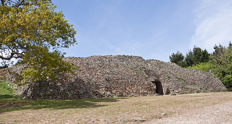
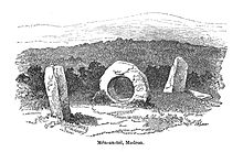
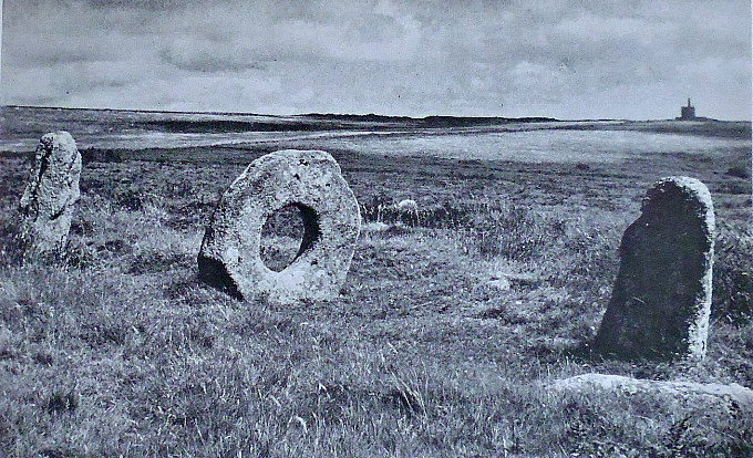
OS grid reference: SU 0991 6990. In the village of Avebury close to the manor house and just 100 metres west of the famous stone circle, stands St James’ Church, a building that is of Anglo-Saxons origins. Located on Church Walk, just north of High Street, in the centre of this charming village, but outside of the pagan stone circle. Christianity came late to Avebury – due, perhaps, to the allure of the 3 pagan stone circles standing within a sizable circular enclosure, covering 24 acres, 1,400 feet across, and nearly 1 mile in circumference which virtually surrounds the village, its grassy bank being upto 5 metres high and the ditch about 25 metres wide. The stone circles date from the late Neolithic between 2,900 to 2,500 BC. When Christianity did finally arrive here in about 1000 AD the people were ‘still very slow’ in adapting from their heathen ways to something much more profound, fulfilling and everlasting. The church houses a beautiful medieval tub font which is carved with a superb dragon, a depiction of paganism (the Devil) being stamped on and a new religion, Christianity, being heralded in. There is also a fragment of an Anglo-Saxon cross and a number of other ‘quite delightful’ architectural things to see inside the church. Avebury is 6 miles east of Marlborough on the A4 (Bath Road) and 8 miles from the town of Chippenham in the west, again on the A4 road. Stonehenge is 17 miles south, close to the A303 road, near Amesbury.

St James parish church is largely Norman although there are some earlier, Saxon features, in particular the two round-headed windows in the Saxon nave wall, while the three rather odd-looking circular, porthole windows at a higher level, are late Anglo-Saxon or perhaps early Norman? There’s also a very interesting squint hole. The church was probably added to in the 12th century. Also, there is a partly restored 15th century rood loft, but sadly the rood itself was destroyed during the atrocities of the Reformation. At the north-west corner embedded in the wall part of an Anglo-Saxon cross-shaft with carvings. The tower with its stair-turret is 15th century Perpendicular. At the south-side a superb Norman doorway which, according to the author Simon Jenkins in his delightful book ‘England’s Thousand Best Churches’, 2000, “offers a lovely composition of foliated capitals and a zigzag arch beneath an empty saint’s plinth.” But the best antiquity here is undoubtedly the 12th century tub font with its beautiful early Norman carvings. Restoration to St James’ was carried out in the 19th century.

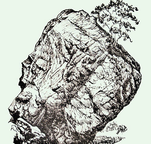
The font dates from the early 12th century and is exquisitly carved with a Christian figure that appears to be ‘stamping out paganism’ and heralding in the new religion with “one” eternal God. A bishop or ecclesiastic wearing a “short skirt” is depicted with his crozier in one of the intersecting arches stamping on a winged serpent (dragon) with a long never-ending curling tail which, at the same time is biting his foot or cloak; this is an obvious reference to the battle between the established ‘serpent-power’ worship of the pre-Christian temple at Avebury, and the new Christianity, according to Janet & Colin Bord in their book Mysterious Britain, 1984. Quite clearly it can be seen as ‘the Devil’ getting his final come-uppance and Christianity securing its position as the true and everlasting faith. There is a second serpent with a long curling tail. The font is also adorned around the bottom with columns that have bands or cords shooting out from their tops to form the intersecting ‘domed’ arches.

Sources:

Janet & Colin Bord, Mysterious Britain, Paladin (Granada Publishing Ltd)., London, 1984.

Jones, Lawrence E. & Tricker, Roy., County Guide To English Churches, Countryside Books, Newbury, Berkshire, 1992.

Darvil, Timothy., Ancient Britain, AA Publishing Division, Basingstoke, Hampshire, 1988.

Anderton, Bill., Guide To Ancient Britain, W. Foulsham & Co Ltd., London, 1991.

Ashe, Geoffrey., Mythology Of The British Isles, Methuen, London, 1993.

Click on for images of the church  http://greatenglishchurches.co.uk/html/avebury.html

Click on for images of the church  http://www.anglo-saxon-churches.co.uk/images/avebury.pdf


Gavrinis Tumulus, Gulf of Morbihan, Brittany, France

Entrance to Gavrinus Cairn (Photo Copyright: Wikipedia)

Entrance to Gavrinus Cairn (Photo Credit: Myrabella, Wikipedia)

Latitude 47, 571835 Longitude -2,898588. In the Gulf of Morbihan 1 mile south of Larmor-Baden in the Bretagne-Morbihan region of Brittany is Gavrinus Island (Ile de Gavrinis) with, what is considered, a world-famous prehistoric burial mound called Gavrinis Tumulus. The burial chamber at the south-side of the island is ‘variously’ referred to as a tumulis or cairn, dating back to the Neolithic 5,000 to 6,000 years. It is said by those historians that are proficient in this type of ancient monument to be the best preserved passage-grave in Brittany, and maybe Europe, if not the world, though there are other “equally good” burial mounds in Europe, one in particular being Newgrange in Southern Ireland. Gavrinis means Isle of Goats. To reach the island of Gavrinis you need to get a boat from the embarking point in the port of Larmor-Baden, but it’s only a short trip of 10 minutes! The town of Vannes is some 12 miles to the north-east on the D136 and D101 roads.

Gavrinis Decorated Stones (Photo Credit: Wikipedia)

Gavrinis Decorated Stones (Photo Credit: Wikipedia)

The great mound of Gavrinis measures 23 feet in height (7 metres) and is 328 feet in circumference (100 metres). The diameter of the mound is between 50 and 60 metres (164 feet to 196 feet). It was built around 3,500 BC and was made of earth and large stones that are piled on to the top of the burial mound. Deep inside the mound a gallery (passage) 43 feet long is covered over by stones – with 50 slabs, 23 of these are supporting slabs on top of which there are 9 capstones or tables, leading to a square-shaped burial chamber. The stone supports are richly adorned with beautiful carvings, including pattern-work, symbolism, animals and what could be a human figure – also zigzag decoration, lozenge shapes, abstract circles, axes, arcs, and snake-lines. Undoutedly, this was a funery tomb for some high-ranking person, maybe a chieftain or a king; the ceiling above is made of a large (single) stone-slab measuring 12 feet (4 metres) long by 9 feet (3 metres) wide and weighing upto 17 tons, which rests upon 8 more stone supports standing in a rectangle. The entrance (portal) is built with large slabs, two at the sides and one at the top, while the sides (faces) of the mound are stepped or tiered with thousands of large lumps of stone, not to disimilar perhaps to the pyramids at Giza in Egypt! There are some ‘spectacular’ panoramic views to be had from the tumulus of Gavrinis of the Gulf of Morbihan and the surrounding areas for many miles around, in every direction!

Gavrinis was discovered back in 1832 and excavations began in 1835. In more recent years, the 1960s through to the 1980s there have been further excavations and, in recent years (2011) the decorated stone slabs from inside the chamber have been ‘thoroughly’ researched. A few miles to the south is the tiny island of Er Lanic and two stone circles (together) in the form of a figure-eight – half of the circle now being submerged in the sea. To the north of Gavrinis Island, near Auray, stands the burial chamber or tumulus of Er Grah and, near that close to Locmariquer is Les Table des Marchand. The renowned archaeologist and writer, Aubrey Burl, visited Gavrinis and ‘seems’ to have been “very enthusiastic” about what he had seen of the cairn. Burl was later to describe this and other ancient monuments in his book ‘Megalithic Brittany,’ 1988. Burl said of Gavrinis “It is for its art that Gavrinis is famous.”

Sources:

Michelin Tourist Guide ‘Brittany’, Michelin Tyres Plc, London, 1983.

Insight Guides ‘Brittany’, Ed: Brian Bell, (First Edition) APA Publications (HK) Limited, 1994.

Burl, Aubrey., Megaliths of Brittany, Thames & Hudson, London, 1985.

http://en.wikipedia.org/wiki/Gavrinis

http://www.knowth.com/gavrinis.htm

http://www.academia.edu/5015454/Gavrinis._The_raising_of_digital_stones


Ballygowan Rocks, Argyll and Bute, Scotland

Ballygowan Cup-and Rings (Photo Credit: Wikimedia*)

Ballygowan Cup-and Rings (Photo Credit: Wikimedia*)

Os grid reference: NR8162 9778. In Kilmartin Glen, Strathclyde region, Argyll and Bute, near to the village of Slockavullin there is a fenced-off area with an outcrop of rocks called Ballygowan Rocks, which are covered in prehistoric rock-art, dating back thousands of years to the Bronze-Age. The site is located beside a path and close to woodland about half a mile north of Tayness Cottage, Ballygowan, half a mile south-west of Slockavullin village and, to the north-west of the B8025 and A816 roads and Kilmartin burn. Ballygowan is a solitary little hamlet with no more than a few cottages. Kilmartin is one-and-a-half miles to the north-east and the town of Lochgilphead 10 miles south on the A816. This area is particularly rich in prehistoric rock-art, so you don’t have to go far before you come across rocks covered in cup-and-ring markings. It is well-worth the long trek, in the end at any rate!

The Ballygowan cup-and-ring markings are carved onto the flat face of an outcrop measuring 2.5 metres. There are said to be at least 70 small, medium and large cup-and-rings here, some having radial grooves that link up with the cups, while other enlarged cups seeming to go into the natural cracks in the rock, and many having slightly deeper rounded centres than their counterparts. One cup-marking in particular resembles a horseshoe with several rings that stop at a ‘junction’ and then go outwards from the cup itself, while larger cups (some oval-shaped) go off into the naturaly-formed cracks in the rock’s surface; also there are ‘radial’ grooves or gulleys which link-up with other cups-and-rings. This type of rock-art is said to date from the Bronze-Age, around 2,500 BC.

But why were these strange cup-markings and other patterns designed like this, and for what reason were they carved? Were they used for aligning the stars and constellations, or perhaps the setting of the moon. Maybe they were to ‘align’ features on the horizon, such as hills, mountains and valleys? Maybe we will never know for certain, we can only guess. But they must have mean’t something to our ancient ancestors as they wouldn’t have spent so much time carving these strange shapes.

There are other cup-marked rocks in Kilmartin Glen at Achnabreck, Cairnbaan, Kilmichael Glassary and, further to the north at Buluachraig, all well-worth visiting.

Sources:

Darvil, Timothy., Glovebox Guide – Ancient Britain, The Publishing Division Of The Automobile Association (AA), Basingstoke, Hampshire, 1988.

Canmore Site No: NR89NW 99 & ID 76384 http://canmore.rcahms.gov.uk/en/site/76384/textcontribution/ballygowan/

*Photo Credit: http://commons.wikimedia.org/wiki/File:Ballygowan_Cup_And_Ring_Marks_20120414_detail.jpg

The Megalithic Portal: http://www.megalithic.co.uk/article.php?sid=1863884826


Castleberg Hillfort, Addingham, West Yorkshire

Castleberg Hillfort (Photo Credit) Geolocations David Spencer.

Castleberg Hillfort (Photo Credit: Geolocations David Spencer)

OS grid reference: SE 0912 4943. Just half a mile to the north-east of Addingham at Nesfield, West Yorkshire, is Castleberg Hillfort, said to date from the Iron Age although the site has never been properly excavated by archaeologists and therefore it could be earlier, maybe late Bronze Age, which would then make it an enclosure or settlement, and quite probably the Roman legions came this way on their way to the fort at Ilkley (Olenacum or Olicana?) and maybe ‘made camp’ here on the hill at some point; the name Castleberg is distinctly a Roman one. The hillfort stands at the top of a naturally-formed hill that has a Limestone scar at its southern side. Much of the western side of the site is covered in woodland which stretches down to the river Wharfe, while a little further to the south, opposite Low Mill village, and hidden in trees beside the river lies the famous Castleberg scar, which is actually a Limestone crag. The town of Ilkley is 3 miles to the east on the A65 and Bolton Abbey is 9 miles north-west along Bolton Road and then the A59.

The shape of the hillfort is quite odd, really, mainly because it follows the contours and curve of the hill. It measures, roughly, 140 metres in width, 130 metres lengthwise and 130 metres in diameter; the earthworks being more visible at the eastern side and at the western and north-western sides where earthworks run off from the fort itself; the south-side of the hillfort follows the natural curve of the hill above the river Wharfe. A few well-known Victorian antiquarians and historians have visited this site and more or less they all agree with each other with regard to Castleberg, though there is still much uncertainty about its true age – the Stone Age through to the more recent, Roman period? There have been a couple of finds dating from the Bronze-Age, but nothing particularly substantial. This man-made defensive hillfort would have provided its occupants with a panoramic view of the surrounding area for miles around and would ‘certainly’ have given them prior warning of any signs of hostility advancing up the Wharfe valley.

On Addingham Low Moor just east of the village, near Woofa Bank, there are several more ancient sites including: tumuli, enclosures and round dikes, making this a very rich area of prehistory, while to the south-east there is Ilkley Moor with many, many more ancient antiquities. St Peter’s Church at Addingham (SE0851 4969) is said to have been built on a pagan site though the present building is 15th century; it houses a a very nice carved section of an Anglo-Saxon cross, dating from the 10th century.

Sources:

The Northern Antiquarian  http://megalithix.wordpress.com/2008/09/28/castleberg-nesfield/

Photo Credit  http://www.geolocation.ws/v/W/File:Castleberg%20Fort,%20Nesfield%20-%20geograph.org.uk%20-%2060792.jpg/-/en

Bell, Richard., Village Walks in West Yorkshire, Countryside Books, Newbury, Berkshire, 1998.


1 Comment

St Gregory’s Well, Clooncree, Co. Galway, Southern Ireland

Holy Well (Photo credit: Fr John Musther.

Holy Well (Photo credit: Fr John Musther)*

Irish grid ref: L6537 5807. Close to the eastern shoreline of Lough Ballynakill (Loch Bhaile na Cille) at Doonen, near Clooncree, in Connemara, Co.Galway, is St Gregory’s Well, a pre-Christian healing spring that is dedicated to St Gregory (Ceannanach), a follower of St Patrick, who died about 500 AD. The well is a roughly half a mile to the southeast of a ruined 15th century chapel (on Cartron road), which is also named for this saint. The chapel stands at the top end of the large graveyard, now almost submerged in foliage and in a rather sorry state of repair; originally it would have been a fairly large, ornate building. Close to the ruined chapel there is a small, carved pillar-stone with an incised cross. St Ceannanach (Cononagh) was a native of Iararna at the southeastern side of the Aran Islands and is said to be buried at Inishmaan where Tempull Canannagh was founded by him in the 5th century AD. According to legend, the saint was martyred for his faith on the eastern shoreline of Lough Ballynakill where a stone, said to have blood stains on it, used to stand at the place where the saint died. The little village of Cartron (Moyard) is 1 mile to the north-west of Clooncree on the Tooreen road, while Cleggan is 2 miles to the west on the coast. Ballynakill means ‘The Lake of Church Town.’

There isn’t a great deal to see of the ancient well close to the Doonen road, to the east of the lough, just an opening down amongst some rocks but, almost certainly in the past it would have been regarded as a place of pilgrimage and the water no doubt having healing properties due to the very fact that an early Christian saint was murdered here, indeed, according to the well-told legend St Ceannanach the son of an Irish king was set upon by a pagan chieftain from Bundowlish who was ‘greatly’ annoyed at the holy man’s fervent desire to spread the Christian message in his territory; where the saint was beheaded there was a stone which forever afterwards was stained with blood. However in recent times the bloodstone, as it was called, has been lost although local children used to try and find it! Legend also says that: after being martyred the saint picked up his severed head, washed it in the well, and then miraculously re-attached it to his body. The well is 2 feet wide and surrounding it a stone-wall some 4 feet high, while the well enclosure is 12 feet in diameter; its spring issues from deep between some rocks and, when it is flowing properly it forms a little stream or rivulet. In days gone by pilgrims performed the Stations of the Cross round the well on sundays, but more especially on the saint’s feast-day 10th March.

Cross-Slab (Photo credit: Fr

Cross-Slab (Photo credit: Fr John Musther)*

St Ceannanach’s 15th century church at Cartron (Irish grid reference: L 6479 5828) is now in a very ruinous state, with only two gables left and fragmentary walls in between, nature having almost taken over with trees and bushes growing where the congregation once sat. However in this state it looks quite romantic and even evocative. There were churches on this site before the present one, one of which was said to have been built by the saint himself, or maybe by his followers? The church was 60 feet in length and 20 feet in width, its wall being 8 feet high; the east gable is 15th century, while the west gable retains its twin-light windows and a circular feature above. Close to the ruins (12 metres northeast) there is an early Christian pillar-stone with a thin incised cross, dating perhaps from the 6th century? But the centre of Ceannanach’s missionary work was on the Aran Islands, especially at Inishmaan where he founded an oratory called Tempull Cannanagh (Cononagh), which is now a ruin, and, at Iararna (southeast point) of the Aran Islands, his gravestone can still seen. He is probably to be identified with ‘Gregory the Fairheaded,’ while ‘Gregory Sound’ beyond Cleggan is ‘thought’ to be named after him – alluding to another, or the same legend concerning the saint’s martyrdom.

Sources:

Previte, Anthony., A Guide to Connemara’s Early Christian Sites, Old Chapel Press, 2008.

*Photo Copyright: This work is licensed under a Creative Commons Attribution-NonCommercial-ShareAlike 4.0 International License

*http://www.earlychristianireland.org/Counties/galway/ballinakill/

http://www.megalithicireland.com/Ballinakill%20Medieval%20Church,%20Galway.html

http://oughterardheritage.org/static.aspx?idtxt=terms

Copyright © Ray Spencer, The Journal of Antiquities, 2014 (up-dated 2021).


Ring Stones Hill, Catlow, Nelson, Lancashire

Ring Stones Hill Farm, near Catlow.

Ring Stones Hill Farm, near Catlow.

OS grid reference: SD 8933 3670. On the tops above Nelson, Lancashire, to the east and about halfway between Delves Lane and the hamlet of Catlow there is a farm called Ring Stones Hill, where up until about 1856 there stood a large stone circle, or maybe a cairn circle, but sadly there is no trace of this ancient monument today – the stones having been robbed-away to build walls and some perhaps incorporated into the out buildings of the farm. Nothing much has been recorded about this prehistoric stone circle, only the name survives. However there may be stones belonging to this ‘now lost’ Bronze-Age monument in nearby walls, and one or two having being put into use as gateposts! Ring Stones Hill Farm, whose barn is ‘thought’ to be built over the stone circle, is situated roughly between Delves lane and Crawshaw lane to the south-west of Knave Hill. There is nothing to see, only fields, although on closer inspection there is a scattering of stones buried in the ground in a sort of circular fashion in the field just to the east, close to Pathole beck. Catlow is about half a mile from here along Crawshaw Lane, Walton Spire (Walton’s Monument) which is partly a Dark Age monolith, dating perhaps from the 10th century, stands just to the north, while the town of Nelson is 1 mile to the west.

Recumbant Stone, near Ring Stones Hill.

Recumbant Stone, near Ring Stones Hill.

In the book ‘Historic Walks Around The Pendle Way,’ 1990, local authors John Dixon and Bob Mann give an interesting insight into Ring Stones Hill saying: “Nestled above Pathole Beck is the whitewashed farmstead of Ringstones Hill, a 17th century building displaying many fine mullioned windows. Up to around 1850 a large circle of stones stood next to the house, sadly the circle was dismantled when the present barn was built with only the name to give memory to the former monoliths.” A large stone on the ground below the wall-still which gives access to the field from Delves lane is of interest. Could this be one of the stones that formed the stone circle? Maybe. Just to the right of this path on the shoulder of the hill there is a very faint earthwork of what is possibly an ancient burial mound. Authors John Dixon and Bob Mann mention this in their book ‘Historic Walks Around The Pendle Way’. They go on to say: “What could be a burial mound is sited in a field above the farm at SD 89263693. This is in the form of a small mound, 3m. in diameter.”

Site of burial mound near Ringstones Hill Farm.

Site of burial mound near Ringstones Hill Farm.

The origins of the name Catlow are somewhat confused. Cat could be an Old British word ‘catu’ meaning ‘war’ or ‘battle’, and similarly the Celtic word ‘catt’ also meams ‘battle’, whereas ‘low’ is usually taken to mean mound or henge; so here we have ‘battle at or near the henge’. And ‘cat’ might also refer to ‘feral cats,’ oddly enough! Over the years there have been a number of archaeological finds in and around Catlow Quarries and also in the vicinity of the ancient hamlet. In 1854 two decorated cremation urns were dug up by quarry workmen and, in 1845 a Bronze-Age tanged spear or dagger was excavated in Catlow, and in 1954 a third cremation urn was discovered to the south of the quarries; these were of the Pennine type that are called ‘collared’ urns, dating from the middle to late Bronze-Age. There have also been a few finds of Roman coins in this area and also at Caster-cliffe, about 1 mile north of Catlow.

Sources:

Dixon, John & Mann, Bob., Historic Walks Around The Pendle Way, Aussteiger Publications, Barnoldswick, 1990.

The Northern Antiquarian:  http://megalithix.wordpress.com/2013/12/14/ring-stones-hill/


Men-an-Tol, Madron, Cornwall

Men-an-Tol, Cornwall, by J.T.Blight, 1874. (Photo courtesy of Wikipedia)

Men-an-Tol, Cornwall, by J.T.Blight, 1864. (Photo courtesy of Wikipedia)

OS grid reference: SW 4264 3494. On the moors about halfway between Morvah and Madron, in Cornwall, stands the late Neolithic monument known as Men-an-Tol (the holed stone), with three standing stones and one now lying down, dating back to between 2,000-3,000 BC the late Neolithic to early Bronze-Age. This alignment of stones lies on a moorland footpath which branches off a track just to the west of the site. Here there is an alignment of three standing stones, the central stone (the Crick Stone) has a very large hole, while the fourth stone is recumbant; there may have been others here when the site was much bigger – quite a bit of the monument having been robbed-away over the centuries, prior to which it may have formed a circle of stones. Nearby, there are other prehistoric sites of interest. Madron village is 3 miles to the south-east, the town of Penzance is 3 miles to the south, and St Just is 4 miles to the south-west.

The three standing stones are all roughly 1.0 to 1.2 metres (3 foot 5 inches to 4 feet) high, the large ‘perforated’ hole in the central, round-shaped stone being 0.5 metres (1 foot 6 inches) in diameter (though Borlase, in 1749, says it is 1 foot 2 inches), and each stone is about the same distance apart (8-9 feet); the western-most stone was moved to its present position in the early 19th century and aligned with the others – along with the recumbant stone there are five or maybe six other outliers buried in the ground close-by, which make-up this circular ancient site, covering upto 18 metres (59 feet). To the south-east there are the faint earthworks of a cairn, its low mound just visible. Over the last two hundred years or so antiquarians have often ‘pondered,’ and been ‘rather puzzled’ as to whether these standing stones once formed a much larger stone circle and, some go even further, in thinking there was once a burial chamber or mound here, though today there are no signs of either of these, very sadly.

Men-an-Tol Standing Stones in Cornwall.

The holed-stone was obviously used for fertility rituals and, maybe even magic, and the pointed stones next to it being ‘phallic in shape’; this being borne-out through the folklore and customs of the locality and its people in ‘days gone by’. The well-known authors Janet and Colin Board in their book ‘Mysterious Britain’, 1984, say that: Many of these stones are supposed to be helpful in curing certain illnesses, and children were once passed through the Men-an-Tol when they were suffering from rickets. Stones with holes big enough to crawl through, and with similar beliefs attached to them, can be found all over the world. There may once have been some benefits to be gained from such customs, …….certain stones can hold powerful currents passing through the earth, could not the hole serve as a focus for this power, which would pass into the body of, and give renewed vitality to, anyone climbing through the hole?” Young people would come to the holed-stone in order to consult the stone (oracle) with regard to their future love life, and two pins would be placed like a ‘cross’ on top of the stone and then they would, hopefully, move in a certain way. “This was interpreted in answer to a question put to the stone,” according to Bill Anderton in his book ‘Guide To Ancient Britain,’ 1991. Young children with tuberculosis, rickets and spinal problems were passed through the holed-stone three times, while a ‘childless’ women would have to crawl through the hole nine times to receive a cure. After that, hopefully they were cured!

There are several other important prehistoric monuments close by, the closest to Men-an-Tol being Men Scryfa Standing Stone, half a mile to the north, and The Nine Maidens Stone Circle, 1 mile to the north-east. And 2 miles to the southwest is Lanyon Quoit.

Sources:

Bord, Janet & Colin., Mysterious Britain, Paladin Books (Granada Publishing Ltd)., London, 1984.

Anderton, Bill., Guide To Ancient Britain, Foulsham & Co. Ltd., London, 1991.

Darvil, Timothy., Ancient Britain (Glovebox Guide), The Automobile Association (The Publishing Division), Basingstoke, 1988.

http://www.megalithics.com/england/menantol/mentmp.htm

http://sacredsites.com/europe/england/men-an-tol_cornwall.html

Wikipedia  http://en.wikipedia.org/wiki/Mên-an-Tol

https://en.wikipedia.org/wiki/M%C3%AAn-an-Tol

© Ray Spencer, The Journal of Antiquities, 2014 (up-dated 2019).


The Bowder Stone, Rosthwaite, Cumbria

The Bowder Stone, Cumbria

The Bowder Stone, Cumbria

OS grid reference: NY 2540 1641. In the valley of the river Derwent, in Borrowdale, just north of Rosthwaite in a woodland clearing on the opposite side of the road from the river, stands a huge glacial boulder shaped like a human head that is one of several Cumbrian curiosities and, which has locally been called The Bowder Stone or Balder’s Stone, after the son of the Norse god, Odin (Woden). This ice-borne rock was carried down the valley by a glacier many thousands of years ago and deposited having been trapped and then dislodged between the two side-slopes of the river valley. Today, the massive rock has become a tourist attraction and a photographer’s delight! And many antiquarian writers have travelled here to see the stone and maybe “try”and measure its height and girth, and to be amazed at this wonderous geological curiosity. The village of Rosthwaite is 1 mile south on the B5289 road and Grange is roughly one and half miles north-west, while the town of Keswick is 5 miles in the same direction from here.

The Bowder Stone (Geograph)

The Bowder Stone (Geograph)

The Bowder Stone is 36 feet high (10.9 metres), 62 feet long (18.8 metres) and 90 feet (27.4 metres) in circumference though ‘a few’ might, perhaps, argue with these approximate measurements! It is said to weigh somewhere between 1,970 to 2,000 tons, give or take a few! Geologically speaking the huge rock was brought to its present position by a ‘retreating glacier’ moving south from Scotland during one of a number of Ice Ages 12,00-15,000 years ago; this being a well-known fact because the rock is not from the local area, which is largerly volcanic in its geological make-up. It is a free-standing erratic in that it does not touch the surrounding rocks, but simply balances and pivots deep in the ground beneath it. The rock is shaped like a human head, or several heads with faces – you can easily see a nose, eyes and mouth on at least three different parts of the stone if you look closely at it, indeed you might see more than three! A step-ladder allows access to the top of the stone where a good panoramic view can be had of the Derwent Valley and Upper Borrowdale; the various marks and holes in the stone have been made by climbers. There are other glacial erratic rocks close by, but none of them quite as big as The Bowder Stone.

The Ward Lock Red Guide (Lake District) 1975 sums up the rock quite nicely: “A mile from Grange Bridge and immediately beyond a large slate quarry is the famous Bowder Stone, a remarkable rock of prodigous bulk, which lies like a ship upon its keel.” And author Maxwell Fraser in his book ‘Companion Into Lakeland’, 1939, says: “The chief tourist site of Borrowdale is the curious geological feature, the Bowder Stone, a poised block of stone 36 feet high which is reckoned to weigh 1,970 tons.” In the great Arthur Mee’s book ‘Lakeland Counties’ we are told about one ancient curiosity of Borrowdale, Castle Crag, a nearby Iron-Age hillfort, and then the author goes on to say: “Another is the curious Bowder Stone, an immense boulder of about 2,000 tons……, which after rolling down the fell-side, has remained balanced on an edge so narrow that through a hole in it two people can shake hands”. According to tradition, two people holding hands through the opening at the bottom of the rock and then making a wish, shall have that wish come true.

Sources:-

Fraser, Maxwell., Companion Into Lakeland (Second Edition), Methuen & Co. Ltd., London, 1939. 

Mee, Arthur., Lake Counties, (Seventh Impression), Hodder And Stoughton Ltd., London, 1961.

‘Lake District’  Ward Lock Red Guide, (edt by Reginald J.W. Hammond), Ward Lock Limited, London, 1975.

The Illustrated Road Map Of England & Wales, The Automobile Association (AA), London, 1962.

Geograph  © Copyright Graham Hogg and licensed for reuse under this Creative Commons Licence.