The Journal Of Antiquities

Ancient Sites In Great Britain & Southern Ireland


Jennet’s Well, Calversyke, Keighley, West Yorkshire

Jennet's Well near Keighley.

Jennet’s Well near Keighley.

Os grid reference SE 0464 4185. Jennet’s Well stands beside a house at the west end of Shann Lane, almost opposite Calversyke reservoir, on Black Hill to the west of Keighley, West Yorkshire. It has variously been called St Jennet’s Well, Jannet’s Well and Jenny’s Well, but as to whom it was originally named for is now lost in the mists of time. Jennet was thought to have been a tutelary Saxon saint who was venerated at Keighley, perhaps at a church that no longer exists, but there is no record of a saint of this name here and so Jennet must be regarded as an obscure or unknown saint. Could it be the word “Jennet” meant something entirely different? Legend says the well at Black Hill stands at a Christianized place, maybe where people in Saxon times could congregate, worship and receive a miraculous cure by the waters of this little holy well, which had become a Christianized spring because a holy person had dwelt there; the spring then having the power to cure illnesses. The town of Keighley is about 1 mile away to the south-east and Braithwaite village roughly half a mile in the same direction.

Close-up of Jennet's Well.

Close-up of Jennet’s Well.

The spring of water flows out from a stone structure and into a square-shaped stone basin that looks to have some faint carvings on it which resemble those from the late Anglo Saxon period; it then runs along a stone gulley, afterwhich it apparently runs under the lane and then on into the Calversyke reservoir, close by. It obviously pre-dates the house by many hundreds of years, but may originally have been used as a source of water by the occupants and others close-by – indeed there are a few records saying the well used to supply the town of Keighley when it was brought to peoples’ homes in stone troughs from the never-failing spring at the west side of the town, according to Stephen Whatley’s ‘England’s Gazetteer’ of 1750. Local folklore says the well was the haunt of the fairy folk in times gone-by. If you are going to look at the well or take photos there [please respect the privacy of the occupants of the house]. There are two other holy wells in this area: True Well and Goff Well.

Sources:

Dewhirst, Ian., A History of Keighley, Keighley Corporation, 1974.

Many thanks to the The Northern Antiquarian:  http://megalithix.wordpress.com/2008/12/29/jennets-well-keighley/

The Megalithic Portal:  http://www.megalithic.co.uk/article.php?sid=26416

Whatley, Stephen., England’s Gazetteer,  J & P Knapton, London, 1750.


The Oxenhope Cross, Oxenhope, West Yorkshire

The Oxenhope Cross, West Yorkshire.

The Oxenhope Cross, West Yorkshire.

Os grid reference: SE0311 3521. Built into a wall near the top of Cross Lane close to the C of E primary school at Oxenhope, West Yorkshire, is an old stone waymaker known locally as The Oxenhope Cross, because it is built in the form of a cross. However, next- to-nothing is known about its history, apart from the odd “snippet” of information saying that it was placed here so that people ‘of a Christian persuasion’ might congregate by it before any church was built for them to pray in. But did this old cross originate here, or did it come from somewhere close-by? And how old is the cross? The answer to these questions is, we just don’t know. Haworth is 4 miles to the north via Stanbury, beyond which is the town of Keighley, and Denholme is 6 miles east on the B6141.

Oxenhope Cross Drawing.

Oxenhope Cross Drawing.

The gritstone cross is very easy to miss as it blends in well with the rest of the wall. It is formed from small, medium and large square-shaped stones, and although it is quite crude it is very effective as a cross. It would seem that the stones forming this cross were chosen carefully and then shaped in the form of a Christian cross, though without any carvings. It is about three foot high. The cross-shaft looks as if it has been broken at some point in the past, before it was set into the wall.

The Oxenhope Cross from a different angle.

The Oxenhope Cross from a different angle.

Here people would congregate and pray before any church in Oxenhope had been built [ie 1836]. This waymarker acted as a sort of signpost for people who had walked as far as Haworth to worship in a church. At the north-west side of the village is the area called Cross Fields, could this be where the cross originally stood, before it was built into the wall on Cross Lane – we may never know. The first record of the cross comes from the early 1830s, but there is nothing known about its age, or history, though it could be a 17th or 18th century waymarker, of which they are several on the moors around here, some having carved inscriptions and crosses, but then again that’s just conjecture.

Source:

http://www.thesunflowertrust.org.uk/OxenhopeVillage/history/snippet.htm


2 Comments

Bainbridge Roman Fort, North Yorkshire

Bainbridge Roman Fort (Photo Credit Gordon Hatton)

Bainbridge Roman Fort (Photo Credit Gordon Hatton)

Os grid reference: SD9383 9013. The very well-defined almost square-shaped earthworks of Bainbridge Roman Fort, lie just a little to the east of the village on the opposite side of the river Bain at a place called Brough – hence the name Brough-by-Bainbridge. The Romans called this fort Virosidvm – ‘the settlement of true men’, or was it perhaps Bracchivm? Thought to have been built in the Late Flavian period – the late 1st or early 2nd century AD and abandoned by the late 4th century, it has a single ditch surrounding the north, east and south sides, leaving this northern military outpost in a resonably well-preserved state of preservation. An earth and stone platform has survived at the south-east side, has have a few Latin inscribed stones and a substantial amount of metalworking debris which now reside in a couple of museums. The north Yorkshire town of Hawes lies 3 miles to the west on the A684 and Aysgarth in the opposite direction is 6 miles, in what is a very beautiful part of The Yorkshire Dales National Park.

The fort of Brough-by-Bainbridge lies on a low, round-shaped hill and measures roughly 99 metres by 80 metres (324 by 262 feet), an area of 1.06 hectares (over 2 acres), so quite a small Roman fort. Hardly anything survives of the inner structure ie annexe, military and living-quarters, or for that matter any associated stonework, though a 3 metre high earth and stone platform is still clearly visible outside the rampart’s SE side. The ramparts are in a good condition on three sides N, E, and S – at the west side 5 irregular spaced ditches survive, while at the north there are maybe 3 irregular ditches? And there were four gateways in the centre of each rampart. Almost certainly an ‘undefended’ civilian settlement (vicus) was established outside the fort in the 3rd century and, there may have been a regular market associated with this settlement, something that we still have in our towns today, according to Arthur Raistrick in ‘The Pennine Dales’, 1972. However there are no signs of the civilian settlement, at least not on the ground!

The fort was occupied by legions between the early 2nd and the late 4th centuries; we know this from three Latin inscribed building and military-type stones found here that rebuilding took place after it was burnt to the ground in the early 3rd century AD – the rebuilding being carried out by the VI cohort of Nervi or Cohors Sextae Nerviorum. An earlier 2nd century timber fort was replaced by one made of stone, something that happened at many Roman forts in Brittannia. Archaeological excavations took place between 1925-26, 1928-29, 1950-53 and 1956-69 when 3 stones with Latin inscriptions were discovered along with a stone bearing a crudely carved mermaid and, also substantial amounts of metalworking material and ingot moulds. It is said there are Roman stones built into a number of cottages and farm buildings in and around Bainbridge.

Roman Road at Bainbridge (Photo Credit Tom Holland)

Roman Road at Bainbridge (Photo Credit Tom Holland)

A resonably well-preserved Roman road which is known to walkers as ‘Cam High Road’ runs south-west from Bainbridge over Dodd Fell and on towards Bentham, Ribblehead and Chapel-le-dale, probably connecting up with the Roman road running south from Calacvm (Barrow-in-Lonsdale) to Ribchester (Bremetennacvm). The nearest fort to Bainbridge (Brough-by-Bainbridge) is Wensley 12 miles to the east, though no Roman road connects to it.


Sources:

Photo Geograph:  © Copyright Gordon Hatton and licensed for reuse under this Creative Commons Licence.

http://www.geograph.org.uk/photo/930341

Photo Geograph:  © Copyright Tom Howard and licensed for reuse under this Creative Commons Licence.

http://www.geograph.org.uk/photo/3289178

Raistrick, Arthur., The Pennine Dales, Arrow Books Ltd., London W1, 1972.

Scott, Harry J., Yorkshire, Robert Hale Limited, London EC1, 1977.

Bedoyere, Guy de la., The Finds Of Roman Britain, B.T. Batsford Ltd., London W1H, 1989.

Click to access 016_2009WEB.pdf

http://roman-britain.org/epigraphy/rib_north_england.htm#broughbb

http://thedales.org.uk/the-roman-fort-at-bainbridge/


1 Comment

The Blacko Cross, Blacko, Lancashire

The Blacko Cross, Lancashire.

The Blacko Cross, Lancashire.

Os grid reference: SD 8541 4187. This largerly forgotten cross or milestone known as The Blacko Cross, is now lost. The boundary stone or waymarker built into a drystone wall 110 metres to the east of the A682 (Gisburn road), Blacko, Lancashire, is similar in design. This is located at the southwest side of Blacko Hill on which stands Stansfield Tower, a 30 foot high folly built in 1890 by a local grocer of the same name, who ‘had hoped’ to be able to see the Ribble Valley several miles to the west from his this. Blacko Hill is quite ancient, indeed a Bronze-Age axe from 1,500 BC was dug-up near the tower in 1952, and there is an ancient dyke “Black Dyke” running down the side of the hill with drystone walls built over it. There are also a number of ditches, pits and quarrying holes around the hill, which is an indication of the history of the hill over the past few hundred years or so. The place-name Blacko simply means ‘Black Hill’. The village of Barrowford is about 1 mile down the road, and the towns of Nelson and Colne a few miles beyond that. Just a little to the north-west is the area called Admergill.

Drawing by Bert Hindle.

Drawing by Bert Hindle.

Sadly, this so-called cross with its Maltese-style cross-shaft has been lost completely. It originally stood at the side of the old turnpike road, now the A682, between the Blacko Bar road and Wheathead lane, close to a well, at which time it was in use as a milestone for what was the Kings Highway, with the place-name “Blacko” carved just beneath the cross. The road links both Gisburn and Clitheroe just has it has done for several hundred years. It is, however, still possible to see where the stone pillar was crudely carved at the top, although even this ‘elegibility’ was slowly being worn away by time and the forces of nature. The cross-shaft appeared to have been broken near the bottom and at the side (see drawing), and then rather poorly restored, which has perhaps added to the demise of this ancient monument. It was originally 4 feet 6 inches high, 1 foot in depth, 8 inches wide in the middle and 5 inches wide at the top where it tapered away. There was some uncertainty about its age, but it was probably late medieval, or perhaps more recent maybe 17th century? It did, however, stand, embedded into a wall, at the south-side of Blacko Hill, before it eventually went missing!

The Blacko Cross, Lancashire.

The Blacko Cross, Lancashire.

In the 2006 epic book ‘The Valley of the Drawn Sword’ by local author and archaeologist John A Clayton the history and topography of Blacko Hill is discussed at length; and the local authors John Dixon & Bob Mann briefly mention this cross in their excellent book ‘Historic Walks Around The Pendle Way, 1990, but next to nothing is known about its “true” history and so we can only make guesses and assumptions as to its age. A very good drawing of Blacko Cross was done by Mr Bert Hindle the local historian some years ago (see above).

Footnote: In the recent book ‘Blacko History And Archaeology’ by John A Clayton the author says the stone set into the wall near Blacko Tower, is in fact, a waymark stone that is contemporary with The Blacko Cross and, therefore not the original, but he says the stone predates the wall that it is set into. So where is the original ‘Blacko Cross?’

Sources:

Clayton, John A., The Valley of the Drawn Sword, Barrowford Press, 2006.

Clayton, John A., Blacko History And Archaeology – The Illustrated Pocket History Series, Number Four, Barrowford Press, 2011.

Dixon, John & Mann, Bob., Historic Walks Around The Pendle Way, Aussteiger Publications, Barnoldswick, 1990.

The Northern Antiquarian:  http://northernantiquarian.forumotion.net/t291-the-blacko-cross-milestone#1368


The Dwarfie Stone, Hoy, Orkney Islands

Dwarfie Stone, Hoy (Photo Credit: Wikipedia)

Dwarfie Stone, Hoy (Photo Credit: Wikipedia)

Os grid reference: HY 2433 0042. In a rugged and rather windswept glacial valley just north of Dwarfie Hammars Plateau on the island of Hoy, Orkney, is an isolated block of stone called The Dwarfie Stone, or Dwarfie Stane, thought to date back to 3,000 BC and, which is in fact a burial chamber (passage grave) hewn out of a massive sandstone block that has two chambers and an adjacent blocking stone. There are other boulders lower down the slope which may have formed an alignment to the Dwarfie Stone. The island is 19kms (12 miles) in length and 10 kms (6 miles) wide, the highest point being Wards Hill (479 metres) at the north-side. Quoyness settlement is 2 miles east of Dwarfie Stone, and Rackwick settlement 4 miles to the west, while the nearest islands are: Graemsay, north-west side, Farra, Flotta and Cava to the east. Orkney Island is the next biggest island a few miles further to the east.

The Dwarfie Stone is a massive block of Old Red sandstone measuring over 8 metres (28 feet) in length, 13 feet wide and 6 feet high at one end tapering to 2 feet at the other end, which is probably a glacial erratic boulder that has been used by Neolithic people living on the island 5,000 years ago. They may have used it for shelter, but in the main they ‘saw fit’ to carve out the boulder and bury their dead in the ‘sanctuary’ of its rock-hewn chambers. There are two small cells or chambers running off from the short passage-way, the south chamber still bears the toolmarks from the hands of the people who carved it out. Above the passage is a strange opening, like a chimney, that used to link up in some way to the entrance blocking stone, something that looks as if it might have inspired film-makers! The square shaped entrance is 3 foot square with the passage being over 7 feet long to where the two cells have carved-out places for burials that would have been difficult to get into by anyone with an ordinary stature – hence the name, according to J Gunn in his book ‘Orkney The Magnetic North’ 1941.

A roughly-hewn stone, shaped like a stopper at one side, lies in front of the entrance and would have almost certainly acted as a blocking stone, rather than any close-fitting door. This smaller stone measures nearly 2 metres by just over 1 metre. Further down the slopes (10-20 metres) below Dwarfie there are a number of boulders scattered around, one in particular is at HY2437 0038. These are perhaps marker stones or outliers aligned to the rock-cut burial chamber back up the steep hillside. Unfortunately, there is some 18th and 19th century graffiti on the Dwarfie Stone, some of this in Latin and Persian, much of it from the Victorian age. There are are said to be signs of a Neolithic agricultural settlement, dating to 3,500 BC in the nearby Whaness Burn just south of Quoyness settlement, according to the author/photographer Charles Tait in his book ‘the Orkney Guide Book’ 1999.

Sources:

Photo Wikipedia: http://en.wikipedia.org/wiki/Dwarfie_Stane

Gunn, J., Orkney The Magnetic North, Thomas Nelson And Sons, Ltd., London, 1941.

Tait, Charles., the Orkney Guide Book, Edition 2.1, Charles Tait Photographic, St Ola, Orkney, 1999.

Ancient Monuments Scotland, Vol VI, H.M.S.O., Edinburgh, 1959.


Gray Hill Stone Circle, Llanfair Discoed, Monmouthshire (Sir Fynwy)

Gray Hill Standing Stone (Photo credit Paul Sheppard/Geograph)

Gray Hill Standing Stone (Photo by Steve Sheppard)

Os grid reference: ST4380 9352. On the southern ridge of Gray Hill* (Mynydd Llwyd) 260 metres (854 feet) above sea-level and overlooking Penhein, Shirenewton, Caerwent and the Bristol Channel, in southern Monmouthshire, stands Gray Hill Stone Circle, a Bronze Age monument said by some historians to be older than Stonehenge! This ancient monument is best reached from Wentwood reservoir, then by ‘climbing up’ the hill and along the eastern ridge, and then dropping down the south-side of the hill to where there are some ancient quarry workings and, just below stands the circle of stones, quite a few of which now lie recumbant. There is another single standing stone over on the north-west side of the hill and another stone to the east on Mynydd Alltir-Fach (also known as Money Turvey Hill) which is aligned with Gray Hill Stone Circle. Llanfair Discoed is 1 mile to the south of the hill, Penhein is 2 miles to the south and the Roman town of Caerwent is 2 miles south-east. Caldicot is about 3 miles to the south-east. [*Gray Hill can also be spelt as ‘Grey Hill’].

Two Standing Stones on Gray Hill (Photo Credit: Wikipedia)

Two Standing Stones on Gray Hill (Photo Credit: Wikipedia)

There are at least 13 stones ranging in height/length between 1.5 and 2.3 metres in a resonably well-defined (albeit broken) circle that is 32 feet (9.8 metres) in diameter, but there are also a few outliers; the stones are ‘said’ to have come from the quarries back up the hill. The circle is broken, miss-shapen at the west and east sides, the stones from these sides having been robbed-away in the mid 19th century. Only two of the thirteen stones are now standing, these are at the north and north-east of the circle, while a third stone has fallen over; one outer stone is still up-right, while another is recumbant. The outer up-right stone may well line-up with the Midwinter sunrise; the north-east stone and the fallen inner stone could also line-up with the Midwinter sunset. The two standing menhirs, which may be part of the cove, are rather jagged and ridged on their tops, one being quite tall, the one other small, but all the stones here are very sturdy and very substantial. It would have been quite a sight when they were all standing in the circle. A sort of ‘processional way’ to the second (outer) standing stone and barrow cemetary are evident at the east side of the circle, according to authors George Children & George Nash in their work ‘Prehistoric Sites of Monmouthshire’ 1996. Aubrey Burl described the monument as a cairn circle in 1977. So, with that in mind it’s plausable to say that there may have been a burial in the centre of the circle.

Fred Hando in ‘Hando’s Gwent’ 1987 seems quite passionate about the monument and informs us about his own theory regarding the circle and says: “when the ancient observers saw their stones in line with these horizon sunrises and sunsets they were able to advise their agricultural tribesmen what the seasons were. Such knowledge was power!”

Authors George Children & George Nash in their work ‘Prehistoric Sites of Monmouthshire’ mention that there is a ‘second possible stone circle’ to the west on Garn Wen at SO2803 2553 which is over 500 metres above sea-level and overlooks the Afon Honddu Valley and, and they go on to say there is a barrow cemetary at ST4410 9320 and a field system in the area of Gray Hill. Children & Nash say that “Gray Hill is regarded as one of the most important Bronze Age landscapes in the whole of Monmouthshire.”

An amusing end piece to this site is given by the author Chris Barber in his book ‘Mysterious Wales’  1987 in which he says: Historian W.H.Greene, in 1893, claimed to discover not one stone circle, but “acres of them” on Gray Hill. He recalled “that the hill was covered with prehistoric monuments and that the number could be counted in thousands.”

Sources:

Photo Geograph:  Copyright Steve Sheppard and licensed for reuse under this Creative Commons Licence

Photo Wikipedia:  http://en.wikipedia.org/wiki/Gray_Hill,_Monmouthshire

http://www.ggat.org.uk/cadw/fun_rit/english/stone_circles/sc2.html

Children, George & Nash, George., Prehistoric Sites of Monmouthshire, Logaston Press, Almeley, Herefordshire, 1996.

Hando, Fred., Hando’s Gwent, ed. Chris Barber, Blorenge Books, Abergavenny, Monmouthshire, 1987.

Barber, Chris., Mysterious Wales, Paladin, London W1X, 1987.

Palmer, Roy., The Folklore of (Old) Monmouthshire, Logaston Press, Almeley, Herefordshire, 1998.

Barber, Chris & Williams, John Godfrey., Ancient Stones of Wales, Blorenge Books, Abergavenny, 1989.


2 Comments

St Teilo’s Church, Llantilio Pertholey, Monmouthshire (Sir Fynwy)

St Teilo's Church, Llantilio Pertholey.

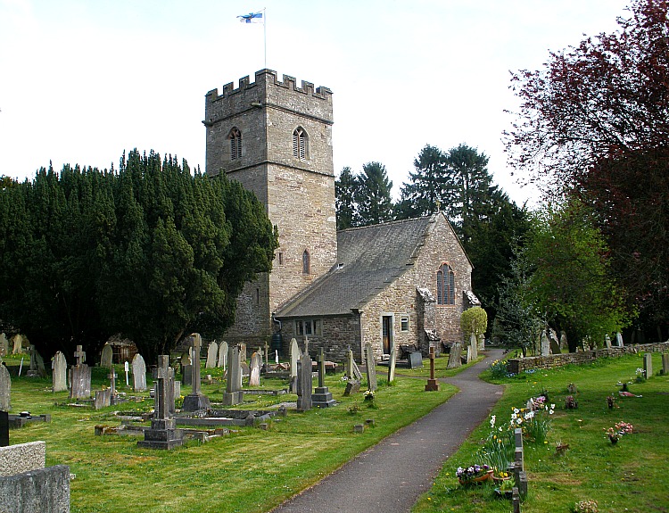
St Teilo’s Church, Llantilio Pertholey, Monmouthshire.

Os grid ref: SO 3114 1632. St Teilo’s Church at Llantilio Pertholey about 1 mile north of Abergavenny (Y Fenny), Monmouthshire, stands in a secluded hollow just off the Old Hereford road, in a lovely, peaceful setting within what looks to be a partly circular churchyard. The church is largerly medieval but there are many different periods built into the structure which can be a bit confusing, if not daunting. At the back of the church there is an ancient yew tree that is said to be 1,200 years old, so there ‘may’ have been a place of worship here in the 8th century? And there is a medieval churchyard cross (south-side) which is now a war memorial.

According to ‘The Legend’ an unidentified holy man called Bevan came here with some companions and established a cell. Bevan was a follower of the renowned Welsh churchman, St Teilo (Theliau), who is said, according to legend, to have died at his monastery of Llandeilo-Fawr, Carmarthenshire, in 560 AD. Teilo had earlier been bishop of Llandaff, succeeding St Dubricius (545). The name Pertholey (Bertholey) and Bertholiau is thought to refer to “a defiled gate” or entrance, but other than that the meaning is uncertain. So why was it defiled? Could it refer to “martyrs”? We know that Bevan was buried here, but he seems not to have suffered martyrdom. Fred Hando in his work ‘Hando’s Gwent’ 1987 refers to ‘The Book Of Llandaff’ for information as to the beginnings of this place; he also says: Pertholey is Porth Halauc – a polluted entrance.

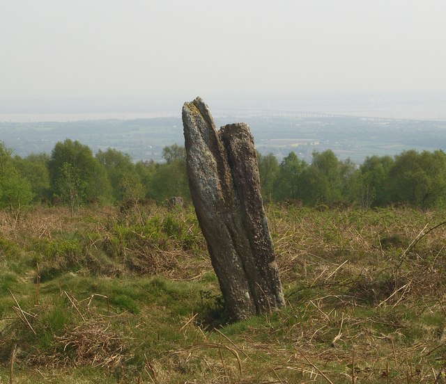
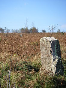
The hamlet of Llantilio Pertholey is just north of Mardy on the Old Hereford road, while Abergavenny is 1 mile south, and the more recent A465 road to Hereford is just a little east of the church. At the edge of the churchyard the river Gavenny makes its way toward the town, and then to Llanfoist. St Teilo’s stands in the shadow of Skirrid Fawr, holy mountain to the local people. A couple of legends, or myths, are associated with the Skirrid – probably in connection with the part of the hill that has slipped away due to an earthquake at the time of Christ’s crucifixion, or it was caused when the giant, Jack o’ Kent tried to jump from the Sugar Loaf to the Skirrid – but missed his footing. There are also remains of an ancient Roman Catholic chapel of St Michael on the top of the hill, now just a few stones in a little grassy hollow.

Another View Of St Teilo's Church, Llantilio Pertholey.

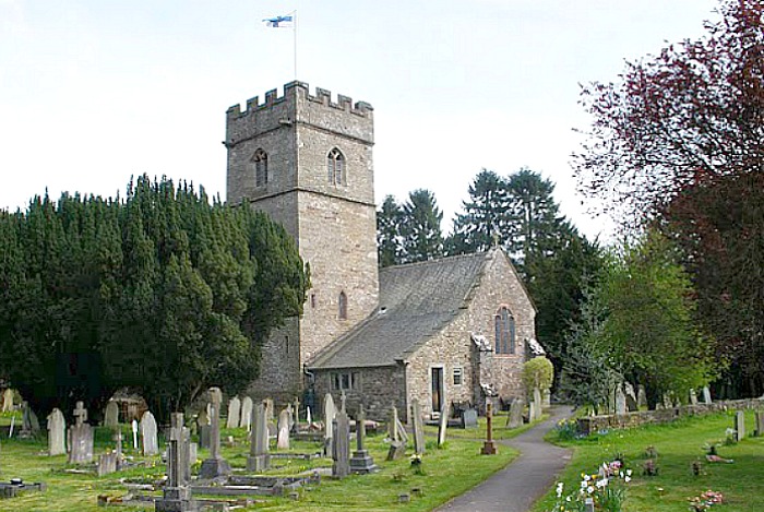
Another View Of St Teilo’s Church, Llantilio Pertholey.

In the 15th century porch there is an ancient holy water stoup (sadly it is broken) and a wooden alms-box (1704). The interior is spacious but everywhere seems to be ‘put to good use.’ Probably the oldest part of the church is the north tower with its 14th century entrance to the stairway, though there may be some earlier, 13th century masonry in the nave, according to Mike Salter in his work ‘The Old Parish Churches Of Gwent, Glamorgan & Gower’ 1991. The east and south arches are of 1350-1400. It is worth pointing out that some of the arches are ‘all out of true’, seem to lean inwards and are irregular, while the two chantry chapels (north and east) date from the 15th and 16th centuries respectively, the 15th century north chapel (Triley Chapel) has a depressed arch, a timber two-bay arcade, a crude stone altar with consecration crosses was originally a stile, a recess in the wall that may have once housed a tomb and some medieval tiles in the floor [church leaflet]. The south chantry chapel (Wernddu Chapel) was added in the 16th century. In the nave the west window dates from 1729. The east chapel (Neville Chapel) is particularly nice as it has graceful oak arches supported by stout oak columns carved with flowers and cable pattern, according to the historian Fred Hando ‘Hando’s Gwent’ 1987.

The octagonal font has a full size bowl and its lid is recent; the angles at the base of the font have carved fleur de lys, according to the church leaflet. I think the most interesting part of this church is the “squint” or hagioscope which afforded a good view of the altar. Canon E.T. Davies in his book ‘A Guide To The Churches of Gwent’ 1977, says that: “It is around the chancel arch that the visitor should looks for squints or hagioscopes, especially at the end of a north or south aisle. These apertures enable those sitting or, more probably standing, in the aisles, a view of the high altar; they are not leper squints.” The piscina in the wall to the right retains some of its original colouring [church leaflet]. So, all in all a very nice interior.

Cross/war memorial in St Teilo's churchyard.

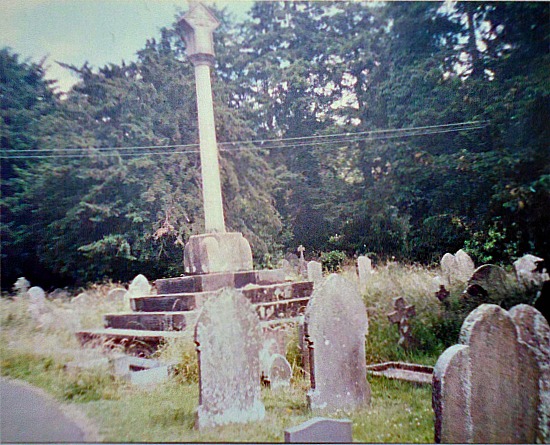
Cross/war memorial in St Teilo’s churchyard.

Outside in the churchyard (south side) stands a beautiful war memorial on a very large chamfered base – the monument is modern but the base is medieval. The churchyard cross used to stand on the base but was destroyed in the 1640s. Close-by, to the west an ancient yew tree that is hundreds of years old and could, therefore, date back to the Dark Ages (the 6th century) when Iddon, son of King Ynyr, gave this piece of land to Llandaff and St Teilo on which to build a church. Above the porch there is a nice shield-shaped sundial. Over on the south-side of the Skirrid (Ross Road) stands the church of St David at Llanddewi Skirrid, while a few miles over to the north-west is the gorgeous little church of Bettws -these two buildings are cared for, and ministered by, the incumbant of St Teilo’s.

Sources:

Salter, Mike., The Old Parish Churches Of Gwent, Glamorgan & Gower, Folly Publications, Malvern, 1991.

Davies, E. T. Canon., A Guide To The Ancient Churches Of Gwent, The Griffin Press, Pontypool, Gwent, 1977.

Hando, Fred., Hando’s Gwent, Blorenge Books, Abergavenny, Gwent, 1987.

The church leaflet (a very useful little guide).

Barber, Chris., Mysterious Wales, Paladin (Grafton Books), London W1X, 1987.


Easter Island, South Pacific Ocean

Easter Island (Ahu-Akivi) Photo Credit: Wikipedia.

Easter Island (Ahu-Akivi) Photo Credit: Wikipedia.

Latitude: -27.1211919. Longitude: -109.3664237. A small Polynesian island in the south Pacific Ocean far away from any major land-mass is Easter Island, only discovered in the early 18th century, but it is a very extraordinary and mysterious island of giant stone statues and rock carvings, some perhaps dating back well-over 1,000 years. Also known as Rapa Nui, the “sacred” island of the mysterious tribe that are also called by the same name and who lived here, roughly, between 400-1700 AD.

There are said to be upto 1,000 small and large stone statues on the island, many are said to represent the gods or chiefs of the Rapa Nui tribes; and there are many superb petroglyphs or rock-carvings scattered about the island. The island is 10 miles across north to south and about 16 miles length-wise at the south-side; also at the south-side a line of three dormant volcanoes: Rano Kao, Punapau and Rano Raruku, while at the north another volcano called Rano Aroi; the island being made of sandstone and volcanic rock. Easter Island, sometimes called ‘the Navel of the World’ is 1,200 miles from any other island and roughly 2,360 miles from any major land-mass – in this case the west coast of Peru. It is 1,290 miles east of Pitcairn Island.

Easter Island by Hodges Photo Credit: Wikipedia.

Easter Island by William Hodges 1775. Photo Credit: Wikipedia.

On Easter sunday in 1722 Dutch sailors, lead by the enthusiastic seafairing admiral Jacob Roggeveen, discovered the barren, treeless island quite by chance and named it Easter Island; they were almost certainly very surprised to see huge stone heads lying on the ground. After that in 1772 Spaniards re-discovered the island and, other interested parties (and some not so interested) came to the island in the late 19th century when archaeological excavations began. In more recent times (1956) the famous Norwegian explorer Thor Heyerdahl (1914-2002) sailed to the island on his balsa-log raft, Kon Tiki. Francis Hitching in his book ‘The World Atlas of Mysteries’ 1979, says of Heyerdahl’s expedition: “In 1956 the writer Thor Heyerdahl arranged an archaeological experiment with the mayor of Easter Island and six islanders. Using traditional methods, they carved out the contours of a new statue in three days using stone tools and gourds of water to soften the volcanic rock.”

Easter Island (Rano Raraku). Photo Credit: Wikipedia.

Easter Island (Rano Raraku). Photo Credit: Wikipedia.

The huge (colossal) statues carved from hardened volcanic ash are called ‘moai’ and they look stern-faced inwards away from the sea, seemingly to gaze towards the horizon for eternity, some stand on ceremonial rock platforms (ahu), especially those at Akivi on the island’s west coast and Nau Nau in Anakena Bay with between 7-15 figures, many having strange top-knots (pukao) on their heads, made from red tuff rock, their eye-sockets are made from coral and the irises from red scoria rock. In all there are nearly 900 statues (most having subtle differences in their appearences), including half-size ones and some that are unfinished, and some kneeling statues. They are said to represent the gods of the Rapa Nui. One of the statues, the ‘paro’ is 33 feet high (10 metres) and weighes in at 76 tonnes; another an unfinished statue is 69 feet high (21 metres), but there are some that are as tall as 24 metres, a staggering 78 feet! Many statues have fallen or been pushed over, maybe by the Rapa Nui tribes themselves as they knew that the end of their island culture was coming – due to a number of factors including abduction for the slave trade, war and disease – indeed by the 1870s only a hundred or so tribes-people remained, and in 1888 the island was finally annexed to Chile.

Author Justin Pollard in his excellent book ‘The Story of Archaeology In 50 Great Discoveries’ 2007, says that “By the 18th century Easter Island was almost devoid of trees and the destruction of the forest to provide wood for building and boats (and perhaps rollers for the moai) and to clear areas for agriculture led to a progressive impoverishment and erosion of the soil. These factors, together with the pressures caused by a growing population, meant that Easter Island society began to change rapidly.”

There are some amazing rock carvings on the island, in particular those in the Ana Kai Tangata cave at the south-west side of the island where there are depictions of the so-called ‘birdman’ (Tangata Manu) the supreme chief. The ‘birdman’ also features on a carved rock located above the Motu Nui islet; the cultus of the birdman was centred on the island village of Oronga where there are some well-preserved houses that were lived in by the Rapa Nui, from 1500 onwards. Thankfully the famous statues of Easter Island have been re-erected and now stare, perhaps rather less stern-faced towards ‘a new horizon.’ Today tourists and archaeologists visit Easter Island to stare and to study the huge statues and rock carvings and, at the island that is slowly ‘being lived on’ once again!

Sources:

Hitching, Francis., The World Atlas Of Mysteries, Pan Books Ltd, London SW10, 1979.

Pollard, Justin., The Story Of Archaeology In 50 Great Discoveries, Quercus, London W1A, 2007.

Strange Worlds Amazing Places, The Reader’s Digest Association Limited, London W1X, 1994.

Photos Wikipedia:  http://en.wikipedia.org/wiki/Easter_Island

http://www.southamerica.cl/Chile/Easter_Island.htm


Le Creux Es Faies, St Peter Du Bois, Guernsey, Channel Islands

Le Creux Es Faies, Guernsey, Channel Islands (J.Dixon-Scott)

Le Creux Es Faies, Guernsey, Channel Islands (J.Dixon-Scott)

Latitude: 49.456047. Longitude: -2.653499. At the south-western side of the island of Guernsey and just to the north of L’Eree Bay, stands the well-preserved prehistoric monument of Le Creux Es Faies, a huge grassed-over mound which covers an ancient burial tomb, said to date back to between 3,500-2,500 BC. The burial chamber or dolmen is located on the Houmet Nicolle headland a little to the north of L’Eree Bay opposite the island of Lihou, in the parish of St Peter Du Bois, on Les Sablons road. Close by there is a concrete watchtower that was used by German troops during the occupation of the channel islands (1940-45). St Peter Port lies on the east coast about 7 miles from here. On Lihou Island there are some ruins belonging to a Benedictine priory.

Le Crueux Es Faies (Mound of the Fairies) is very similar to the La Varde Dolman, also in Guernsey, and to Gavrinis Tumulus, Brittany. The bottle-shaped passageway is said to be between 8-9 metres long and unusually has a chamber that leads off from the main burial chamber (which is round-shaped), while the long gradually narrowing passage has hefty-looking supporting stones along it sides running the whole length into the tomb and, on top of these at one end, two large capstones. The mound at the north-eastern side has been damaged, possibly during the 2nd world war, the sides of the mound are strenghtened by flat upright slabs placed at intervals with a stonework course between each of the slabs, much like at Gavrinis Tumulus. Originally the mound here at Le Creux would have been much higher, erosion having decreased its overall size. The entrance has a huge slab jutting out over it and the approach has large, almost recumbant stones at either side as you descend down into the darkness of the tomb. Le Creux was probably used for burial purposes from the Neolithic through to the late Bronze-Age.

In local myth and folklore we are told that the (portal) entrance to the mound is the ‘gateway to the fairy kingdom,’ the inner part of the monument being referred to as a ‘fairy grotto.’ Here the little people would go about their daily duties, making bread and keeping house in their own fairy realm, being largerly undisturbed by the world outside! They would only venture out to play when darkness had descended and be back inside by sun rise.

During archaeological excavations in 1840 a number of flint arrowheads were discovered, but little else of interest was found, due quite probably to the tomb being robbed-away by locals or antiquity hunters wanting to make easy money.

Sources:

Newnes Pictorial Knowledge, Volume Seven, George Newnes Limited, London WC2.

The Megalithic Portal:  http://www.megalithic.co.uk/article.php?sid=2076070978

http://www.topicguernsey.com/history