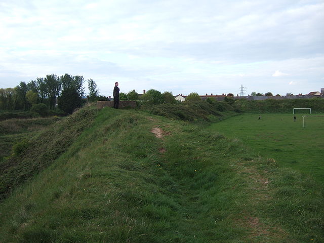
Iron Age hillfort, Sudbrook. (Photo Credit: Wikipedia)
OS grid reference: ST 5053 8732. About half a mile south of Portskewett, Monmouthshire, on the cliffs overlooking the Severn Estuary, is the Iron-Age Sudbrook Camp, a promontory fort with its well-defined earthworks still largely intact, although suffering somewhat at its south side due to coastal erosion. It is known to have been inhabited from roughly the mid-2nd century BC up to at least the 1st or perhaps mid-2nd century AD – at which time it may well have been in use as a Roman trading post. The earthworks are located by going along Sudbrook road and, at the end of Camp road, they are some 50 metres to the south-west, close by the ruins of a 13th century church, some railway buildings, and the Severn Railway Tunnel (Gwent Levels). A coastal path traverses the camp. Caldicot village is 1 mile to the west, while the M4 motorway and the Severn Bridge, are half a mile to the east; the town of Chepstow is roughly 4 miles to the north.
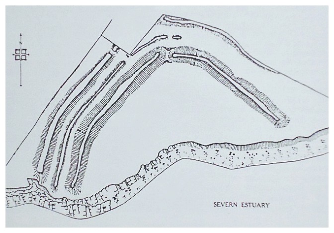
Plan of Sudbrook Camp (After V.E.Nash-Williams) 1936.
Sudbrook Camp is made up of triangular-shaped earthworks. The whole site is 1.4 hectares: the inner section is approx 78 metres between the cliff and the first ditch, 109 metres across south to north and 280 metres in width west to east, but a section at the south-side has eroded away due to cliff falls, and so the camp would have been larger. A section at the north side ‘may’ have been destroyed due the houses and also Sudbrook and Camp lanes. However, the rest is still resonably well-preserved, in particular the fairly deep ditches, three ramparts at the west and two ramparts at the east – indeed the defensive ramparts still stand up to 5.2 metres high, according to the work ‘Prehistoric Sites of Monmouthshire’ by Children & Nash. At the far south-western side of the camp stands a World War II concrete lookout post. Rather oddly the interior of the camp is sometimes used as a football pitch!
Camp road to the north-west cuts off the earthworks, as do the ruins of Holy Trinity Church at the far south-eastern side. The entrance to the camp can clearly be made out at the north side between the ditches and ramparts; this connected up to an ancient trackway which was used by the Silures tribe, and later by the Romans, linking the site to their newly established town at Caerwent ( Venta Silurum) ‘market town of the Silures’, which later became Caer Guent (Fortress Venta), some 5 miles to the west.
Sudbrook Camp would have been inhabited by an ancient Celtic tribe in the Iron Age (150 BC) and, later in 30 or 31 AD, by the Silures, a fierce tribe who worshipped a cat-like diety. The Silures ruled the south-eastern part of Wales. But at this time they were being put under pressure by the Roman legions making their way up the Severn estuary – led by one Julius Frontinus – who set out to invade Siluria, and at which time the Celtic chieftain Caradoc (Caractacus) had fled from north Wales to Sudbrook Camp, or maybe Llanmelin hill-fort, one-and-a-half miles north-west of Caerwent. Caractacus eventually ended up in Rome where he was pardoned by the emperor Claudius (after 51 AD). The Silures were ‘allowed’ to remain at Llanmelin hill-fort until about 70 AD. However, Frontinus did not make much of an inpact, and it was not until 51 AD that the Silures tribe had their so-called ‘last stand’ when attacked and routed by Ostorius Scapula and the XX legion, according to Roy Palmer in his book ‘The Folklore of (Old) Monmouthshire’.
There is evidence to think that after the routing of the Silures tribe from the camp the Romans used the place as a trading-post and, 17 metres below the cliffs in the estuary, there was a natural harbour facility that was used by the newly conquering Roman legions as ‘a possible docking facility’ and naval base (beach-head) for their sailing vessels – up until at least the late 1st century AD, or even the mid-2nd century AD – Bryan Walker’s work ‘The Archaeology And History Of Ancient Dean And The Wye Valley’.
Archaeological excavations were carried out at Sudbrook Camp between 1934-36 at which time many artefacts were found including: bones of oxen, pigs, sheep and goats and, also fragments of iron, glass, Roman bricks and coins. During the excavations, the remains of two V-shaped ditches were discovered between the ramparts (north-west side) of the main bank which, would have been done in four stages. Two steep-sloping revetments of uncoursed drystone walling were uncovered on the inner scarp – ‘Prehistoric Sites of Monmouthshire’ by Children & Nash.
The sad-looking grey ruins of the 12th or 13th century Holy Trinity Church stand at the far south-eastern side of the earthworks, now alas almost hidden by ivy, bushes and trees, with only the front bell-tower gable-wall and a few ruined rear walls still standing; its graveyard has nearly gone over the cliffs. But the main part of the ruin dates from the 17th century, other earlier parts being from the 13th-14th centuries, notably the chancel, while the nave walls may be 12th century. Sadly the church was abandoned and left to the elements in the 1790s, due probably to the erosion of the nearby cliffs – Fred Hando ‘Hando’s Gwent – A Centenary Tribute’.
Fred Hando says of the ruin: “There is no great charm in the grey ruins of Holy Trinity, Sudbrook. It is difficult to account for its erection here, unless it was a private chapel for John Southbrook, who is mentioned in the Wentwood Survey of 1276”. He goes on to say that: “Holy Trinity at Sudbrook was in use, it seems, to the end of the Eighteenth Century. Bradney tells us that one of the last to be buried there was Captain Blethin Smith of Sudbrook, who left instructions that his corpse was to be borne to the grave by six seafaring men”. Captain Smith’s will was dated 1755.
Sources:
Barber, Chris., Exploring Gwent, Regional Publications (Bristol) Limited, Clifton, Bristol, 1984.
Children, George & Nash, George., Prehistoric Sites of Monmouthshire, Logaston Press, Little Logaston Woonton Almeley, Herefordshire, 1996.
Hando, Fred., Hando’s Gwent – A Centenary Tribute, (Ed by Chris Barber), Blorenge Books, Abergavenny, 1987.
Houlder, Christopher., Wales: An Archaeological Guide, Faber And Faber, London, 1978.
http://en.wikipedia.org/wiki/Sudbrook,_Monmouthshire
Palmer, Roy., The Folklore of (old) Monmouthshire, Logaston Press, Little Logaston Woonton Almeley, Herefordshire, 1998.
Walters, Bryan., The Archaeology And History Of Ancient Dean And The Wye Valley, Thornhill Press, Cheltenham, Gloucestershire, 1992.
Copyright © Ray Spencer, The Journal of Antiquities, 2014.
