The Journal Of Antiquities

Ancient Sites In Great Britain & Southern Ireland


Cockersand Abbey, Near Thurnham, Lancashire

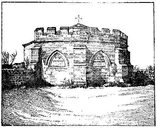
Engraving of the chapter house at Cockersand Abbey. (Wikipedia).

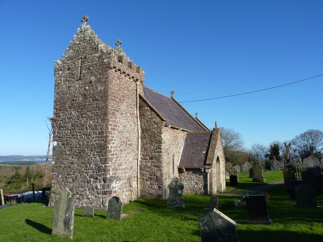
OS Grid Reference: SD 42703 53764. The scant and windswept ruins of Cockersand Abbey, or priory, lie beside the Lancashire Coastal Way on the Moss about 2 miles west of Thurnham and 2½ miles northwest of Cockerham on the Lancaster Road (A588). It is 9 miles south of Lancaster, 3 miles northeast of Pilling, and overlooks Morecambe Bay. Today only the 13th century chapter-house remains intact, whereas the rest of the abbey is now all but a few low walls and earth-works next to the adjacent Abbey farm, which might have some of the stonework of the religious building? Cockersand Abbey started its life as ‘the hospital of St Mary’ for lepers – having been established by Hugh (Garth) the Hermit around 1180. It became a priory in 1190 and, in 1192 the Norman baron Theobald Walter, turned it into an abbey for Premonstratensian canons, whose mother-house was Croxton Abbey, Leicestershire. Cockersand was dissolved in 1539. To reach the site head west out of Thurnham for about 2 miles, passing Haresnape farm. At a junction of two lanes – head south along Moss Lane. After half a mile go west onto the coastal footpath to the abbey. You will see the chapter-house in front of you. You can also reach the site from Bank End Farm in the south, and from Glasson in the north on the coastal path southwards for 3 miles.

1954 1″ Ordnance Survey map of Preston (sheet 94) which shows Cockersand  Abbey.

The infirmary or ‘Hospital of St Mary of the Marsh’ for lepers at Cockersand grew in size under Hugh Garth and it received monies from Croxton Abbey, near Leicester. Hugh was very well-liked and respected by the local people and, because of this, many charitable gifts were given to the hospital, which for 10 years flourished. After the death of Hugh Garth in 1188 or 1189 white canons of the Premonstratensian Order from Croxton arrived in the area, and in a few years they built an abbey onto the hospital building as a cell of their mother-house. In 1230 they added a chapter-house. The abbey was said to have covered 1 acre of land, and to have become one of the three richest abbeys in Lancashire; the other two being Whalley and Furness. Then, in the 15th century the canons built what must have been the first lighthouse in the area to guide sea vessels away from dangerous mud and sand banks. The lighthouse would have been a stone tower with a beacon burning every night. We also know that the fishing rights on the River Lune between Glasson and Thurnham were owned by the canons of Cockersand Abbey, and they owned land at Pilling Hall, a few miles to the southwest, where there are the remains of Pilling’s first church, a medieval foundation served by the canons.

Ruins at Cockersand Abbey by Bob Jenkins (Wikimedia Commons/ Geograph).

However, the abbey’s good fortunes were not to last for in 1539 this religious building was destroyed by King Henry VIII’s soldiers, although the chapter-house was left intact as it was being used as a family mausoleum by the Dalton family of nearby Thurnham Hall. They had the building crenellated in the 19th century. The last Dalton to be buried there was Elizabeth in 1861. Following the dissolution the land was sold off to a local gentleman, John Kitchen (Kechyn) of Hatfield. The abbey’s 14th century choir stalls and Renassance chest were thought to have been taken to Lancaster Priory – though this would seem not to be the case. However the stonework from the abbey was used in the building of Crook farm and there may be some in the walls of the adjacent Abbey farm. There is, apparently, robbed-away stonework in the sea-wall defenses and some pieces of stonework have been found on the shoreline. The canons’ cemetery has long since gone, having been partly Lost to the sea due to the constant erosion; there is archaeological evidence that human bones from the abbey’s cemetery have been found in the sea-wall and also on the seashore. The chapter house is a Grade I listed building.

Richard Peace (1997), says of the place, that it is: “A bleak and forbidding spot on the Lancashire coast marks where a 12th century hermit founded a leper hospital. Originally the building stood on a island, surrounded by treacherous salt marshes. In 1190 Cockersand Abbey was founded on the same spot, its monks battling with high tides which washed away much of their work. By the 15th century it was one of the three richest abbeys in Lancashire. The surrounding marshland had been drained, a quay built, and the first lighthouse on this part of the coast may well have been in operation.

“Today the only part remaining virtually intact is the Chapter House, where the monks once gathered daily to discuss a chapter from “The Rule”, the strict code which governed their lives. After the Reformation a local aristocratic family, the Daltons, destroyed most of the Abbey but turned the Chapter House into a family mausoleum. If the door is open you may enter to discover a beautiful octagonal room with intricate carving.” 

A. J. Noble (2009), tells us more about the Dalton family. He says that: “The earliest recorded burial at the abbey is that of William Hoghton on December 10th 1712. William was brother to John Dalton who had taken the name of Dalton. The last burial was of Miss Elizabeth Dalton on March 21st 1861. He also tells us that: “the abbey remains were acquired by the Catholic Dalton family of Thurnham Hall in 1556.”

Ian & Krysia Brodie (1993) add some interesting bits of information. They say that: “Crook Farm and its shippon incorporate stone fragments from Cockersand Abbey, some of which are recognizable as former door frames and two-light window heads. The authors also add that: “the ruins are the result of dissolution and time. The chapter house remains because it became the burial vault of the Dalton family from nearby Thurnham Hall who had the building crenellated. The last of the line to be buried here was Miss Elizabeth Dalton in 1861, who built some of the houses……. in Glasson Dock.” They also add that: “Just south of [Pilling Hall Farm] lies a small moated site and some rubble — the remains of Pilling’s first church. This dates at least from the early thirteenth century, possibly earlier, and was served by the monks of Cockersand Abbey, who farmed some land at Pilling. It was probably built on a previously pagan site.”

Nikolaus Pevsner (1979), says of the abbey: “Of the Premonstratensian abbey, founded in 1190, there remains only the chapter house and some inarticulate fragments of walls. Excavations in 1923 have shown that the church had an aisleless nave and aisleless choir and transepts with the pairs of straight-ended chapels which were standard Cistercian and Premon-stratensian custom The cloister was S of the church. Walls indicate the E, S, and W ranges. In the E range is the chapter house. This, if it were better looked after, could be a very beautiful room. It is small (27 ft 6 ins.) and octagonal, with a compound mid-pier of four major and four minor shafts and a rib-vault with one pair of tiercerons for each two cells. The pier has one luscious stiff-leaf capital. The doorway is still round-headed.”

Jacqueline Senior writes that: “The Chapter House and Abbey grounds are open on the Saturday and Sunday of the second weekend in September between noon and 5pm for the Heritage Open Weekend.; these are a festival which is coordinated by The National Trust. My husband and I help out by providing visitors with info, show them all various displays, and point out places of interest there (plus sell my booklet for £5). We help to mark out the Abbey site with various posts and signs so people can see how large an area the Abbey encompassed. Our local historian, Robert Parkinson, is a fount of knowledge of this area and it’s well worth having a chat with him. His mother used to tend the lighthouse which used to be in the grounds of Lighthouse Cottage, but has now gone. This cottage still exists on the shore on the left-hand side at the top of Slack Lane. I have copied the Link to a film that was made of her tending the lighthouse.” http://www.britishpathe.com/video/lighthouse-1/query/lighthouse

Sources & related websites:

Bottomley, Frank, The Abbey Explorer’s Guide, Kaye & Ward Ltd., (The Windmill Press), Kingswood, Tadworth, Surrey, 1981.

Brodie, Ian & Krysia, The Lancashire Coastal Way And The Wyre Way, Lancashire County Books, Preston, 1993.

Noble, A. J., (Contributed Article 19 ‘Cockersands Abbey Chapter House’), The North West Catholic History, (Ed: J. A. Hilton), Volume XXXVI (2009).

Peace, Richard, Lancashire Curiosities, The Dovecot Press Ltd., Stanbridge, Wimborne, Dorset, 1997.

Pevsner, Nikolaus, The Buildings of England — North Lancashire, (Reprint) Penguin Books Ltd., Harmondsworth, Middlesex, England, 1979.

Thanks also to Jacqueline Senior for her input. 

The engraving of the chapter house (top) is from ‘Cockersand Abbey’, A History of the County of Lancaster: Volume 8 (1914), pp. 105-06. URL: http://www.british-history.ac.uk/report.asp?compid=53276.

http://www.british-history.ac.uk/vch/lancs/vol8/pp105-106

https://en.wikipedia.org/wiki/Cockersand_Abbey

https://www.britishlistedbuildings.co.uk/101362525-the-chapter-house-cockersand-abbey-thurnham#.WzQKLFK0Vjo

http://wyrearchaeology.blogspot.com/2010/02/whatever-happened-to-cockersand-abbey.html

http://news.bbc.co.uk/1/hi/england/lancashire/6226466.stm

http://www.daltondatabank.org/Chronicles/RDaltonBook/Chapter_1a_History.html

https://historicengland.org.uk/services-skills/grants/visit/the-chapter-house-cockersand-abbey-la2-0az/

© Ray Spencer, The Journal Of Antiquities, 2018.


3 Comments

The Pre-History Of Catlow, Near Nelson, Lancashire

Looking down Southfield Lane to the hamlet of Catlow.

The hamlet of Catlow, near Nelson, Lancashire.

OS Grid Reference: SD 885 368. The hamlet of Catlow lies 1 mile to the east of Nelson town-centre in Pendle, Lancashire. It is a place of historical importance locally but, further back into pre-history, it became archaeologically more important for its Middle Bronze-Age burial sites, which were very sadly destroyed in the mid 19th century. However, if you would care to look more closely from an aerial perspective down onto the hamlet of Catlow, you might just about make out a few “possible” circular features, which could be ploughed-out barrows (tumuli), or could they be just filled-in quarry holes? Back in 1854 quarry-workers at Catlow dug-up two or three pottery urns containing cremations, but on closer examination the urns (or food vessels) fell to pieces, and with time “were lost”. Thankfully these artefacts were recorded. To reach Catlow: from Nelson centre, go past the bus station on railway street, then turn left onto Netherfield Road and then all the way up Barkerhouse Road, passing the Golf Course on the left. At the very top turn right onto Southfield Lane, with the Shooters Inn on the left. Continue down the slope on this lane until you reach a junction of four lanes – this is the hamlet of Catlow and, a bit further down the sunken lane, is Catlow Bottoms! 

The meaning of the place-name Catlow with its two combined words “Cat” and “Low” is probably ‘battle site beside a place of burial’. “Catt” or “Catu” being the Celtic/British word for battle, which in the Welsh form is “Cadd”, while Low or Lowe is a Saxon or Early English name for a burial mound or tumulus. However, some recent historians think “Cat” might refer to feral cats, and so Catlow could have also meant there were cats living by or near a burial mound! Bennett (1957), says with regard to the local place-name of Catlow: (Cattehow 1311) seems to be ‘”wild cat hill”‘ though a later spelling Cattelow suggests ‘”cattle hill”‘.

W. Bennett (1957), says of the Bronze Age period that: “After a period of approximately 400 years, a fresh arrival of settlers initiated another period about 2,000 B.C., known as the Bronze Age, since the newcomers had a knowledge of that metal. It must be remembered, however, that the new metal was very scarce for many centuries and that flint continued to be used for arrow heads, dart points and scrapers right through the whole of the Bronze Age , which lasted until about 500 B.C.

“The people of the early Bronze Age are known as Beaker Folk, so-called from the beaker-shaped pottery vessel which they buried with their dead. They occupied Yorkshire but apparently did not penetrate very far over the boundary into Lancashire, so that the only flint daggers associated with this period that have ever been found in this county were discovered near Hurstwood. These flint daggers may be seen in the Towneley Museum together with tanged and barbed arrow heads, hammer heads, and other flint implements found in the distrct. Two bronze weapons, which have been found locally, date from the Early Bronze Age period; one, found near Blacko Tower, is a plain, flat axe head some 6¼” long, while the other, found near the Old Laund, is a flat spear head of beaten bronze, 4″ in length. The beaker Folk usually buried their dead with one or two beaker vessels in an oblong cist of stones over which a circular mound of earth was raised; such a burial has been found at Lawhouse near Mereclough.”

Catlow Spear.

Bennett (1957), goes on to say that: “The Middle Bronze Age saw a remarkable development in the technique of making bronze articles. Previously, the efficiency of a flat bronze axe head was much impaired because the cleft wooden handle to which the head was tied tended to break when a blow was struck; similarly, a flat spear head tended to break the wooden shaft. In the Middle Bronze period, the axe head was fashioned with flanges on the lateral edges and with a stop ridge on each of its faces so that the cleft wooden handle could be bound more securely to grip the head. In the case of the spear head, the smith made the head with a fairly long tang which was driven into the wooden shaft and secured by a bronze nail through a hole in the tang and a collar that fitted the shaft. Several axe heads with flanges and stop ridge have been found in this area but the most interesting is a spear head with holed tang, 9” long, that was found at Catlow in 1854; unfortunately, the bronze collar was not discovered. 

The general location of the destroyed tumulus at Catlow, near Nelson.

Probable location of the destroyed tumulus at Catlow, near Nelson.

“The custom of cremating the dead was introduced during the Middle Bronze period and quite a number of such burials have been excavated in this area. The excavations have shown that after the body had been burnt the calcined bone fragments were wrapped in a cloth and placed in an earthenware vessel, called an urn, which was then buried, often in an inverted position,   just below the surface of the ground. An area round the burial was then marked off by a circle of boulder stones and into this enclosure were thrown flint implements of all kinds, such as knives, scrapers, grain rubbing stones, arrow heads and broken querns. Such burial circles are almost invariably situated at the top of a hill. A burial of this kind was accidentally destroyed by workmen in 1854 at Catlow and the only important details we know about it are that it contained three urns of which one was a Middle Bronze type and the two others, both broken by a workman’s pick, were food vessels. An earth circle, fifty yards in diameter, which is situated at Broad Bank, overlooking Thursden Valley was excavated in 1951 but the only find was a stone axe head of the Middle Bronze period; a report on the excavation described the earthwork as possibly ‘”a religious enclosure.”‘

Bennett goes on to discuss the Late Bronze Age, saying that: “During the Late Bronze Age, the technique of bronze making was further developed so that both axe heads and spear heads were made with sockets into which the handle or shaft could be fitted. Only on example, a socketed spear head 2½ inches in length, has been found locally. It is said to have been found “‘near Pendle.”‘

“Judging from the many burials and the various types of implements, both bronze and flint, which have been discovered, it would appear that the Marsden and Burnley areas were relatively important in the Bronze Age. It is uncertain what could have attracted people to this area at that period since life in a hut on our moors could not have been very alluring to men and women who knew the arts of farming, weaving and pottery making, even though the climate was drier and more temperate than it had been in the Neolithic Age. That they did live in this district is evident from the finds of jet beads and jet rings (used as ornaments), spindle whorls, loom weights, saddle querns, grain rubbing stones, and implements of all descriptions that would be used in a settled community. The only probable reason for their long existence here seems to be that through this district passed one or two tracks which served as trade routes between the Lancashire coast and the Yorkshire coast. It is believed that the route from the west through northern England proceeded by the Ribble and Calder to Whalley and thence Old Read where a number of Early Bronze Age axes have been found, to Barrowford and Barnolds-wick, where a bronze sword has been found, and so continuing by the Aire Gap to Leeds and thence by river to the coast. Most probably, the flat axe  head discovered near Blacko Tower, is connected with this route. An alternative route from Old Read lay through Higham, Gannow, Towneley, Mereclough and thence by the Long Causeway to the Yorkshire Calder. Near this track several burial mounds and many flint implements of Bronze Age origin have been found. The existence of Bronze Age burials on Bleara Moor on the Colne to Skipton road, at Catlow, at Shelfield (possibly) and at Ell Clough above Thursden Valley may point to a pre-historic track connecting the Whalley-Barnoldswick-Leeds route with that between Whalley-Mereclough-Heptonstall.”

Catlow Row.

H. Hindle, writing a local magazine article called ‘Pre-History – Colne & Surrounding Areas’ in the 1980s, says that: “A Bronze Age dagger or spearhead was found in 1845 about 2½ ft from the surface in a field about halfway between Burnley and Colne in the Catlow district. The dagger had a narrowed  tange with a rivet hole and was just over 9′ in length; the tange was 3′ long and at its greatest width the dagger measured 1½’.The spear’s collar was not found. It seems this spear was, in fact, found underneath the forecourt of Catlow Row as those cottages were built in that very same year. Tanged daggers are extremely rare, being known chiefly from the Arreton Down deposit, Isle of Wight.”, says Mr Hindle.

Catlow artefacts. Top left/bottom (Wilkinson, 1857), top right (Bennett, 1946 & 57).

Hindle goes on to say, that: “The most interesting discovery, a burial site, was made at Catlow stone quarry in March 1854 by Captain Sagar’s workmen. Two or three earthenware urns were met with a little below the surface when clearing earth for the flagstone rock. The urns, probably Pennine collared type, were perfect and measured 14 inches in depth and 9 inches in diameter at the mouth, with considerable swelling at the centres. They are formed from very course earthenware unglazed and very slightly baked. The urns contained calcined bones, pieces of charcoal, and soft dark earth. Most of the bones, supposedly human, are mixed with others belonging to a horse and some lesser animals. Only one of the urns survived due to rough handling by the quarry workers at Catlow who damaged them with their picks; one of the urns was Middle Bronze Age in date, the other two were considered to be food vessels. A rude piece of flint was found amongst the bones, but from its decayed state, it is not easy to determine whether it had been an arrowhead. Two ivory bodkins were found at the same time; they were exceedingly friable, either from age or having been subjected to the action of a fire before being deposited in the urns.

I understand that in 1954 a Bronze Age urn was dug-up from beneath the stone forecourt at the front of Catlow Row. This urn was considered to be very similar to those ones found at Catlow quarry, close by. The urn remains ‘buried where it was found’ (in situ). 

The site entry (No. 19) for the parish of Nelson (Catlow Quarry) in the‘Lancashire Archaeological Bulletin’ (1984), says:- N.G.R. SD 885 368. Primary Reference: Wilkinson 1857; 428 P1. II. Waddington & Wilkinson 1887; 92. Disposition of Finds: Lost. 1854. apparently found by workmen. Two or three urns, cremations, flint, allegedly animal bones, two bone pins perforated at top.

John Dixon & Bob Mann (1990), says that: “In around 1854, workmen hewing stone from the Catlow Quarries came across the remains of three burial urns containing cremations. Two ivory bodkins were also found with the urns. Unfortunately these finds are now lost, but are mentioned and recorded in old texts. A Middle to Late Bronze Age date is ascribed to these finds.” 

John A. Clayton (2014) tells us that there was possibly a hill-fort or settlement of some kind (with a mound in the middle) at Catlow Bottoms, though this would no doubt date to the Iron Age? 

Location of circular features (beside a footpath), just north of Catlow Row.

Although the burial mound (tumulus) at or about SD 885 368 (north-side of Crawshaw Lane, just to the east of the World War II pillbox) was destroyed, there are some other “possible” faint circular features, which might or might not be of interest here. In the fields at either side of Catlow Row. North-side (above the trackway) two very faint circular features at NGR SD 88218 36635 and SD 88185 36542, while at the south-side of the cottages – three small circular features close by a house at NGR 88238 36434. At the northeastern end of Crawshaw Lane, just before you reach Delves Lane, two more “possible” faint circular features: NGR SD 88682 37091 and SD 88894 36867, while on the other side of the lane at the top of the field beside Delves Lane, near the wall stile there’s a faint mound at: NGR SD 89260 36930 and another close to that at: SD 89457 36834; these might be something or nothing, but worth considering. There might be others that I haven’t spotted! And we mustn’t forget there used to be a stone circle hearabouts on Ring Stones Hill (see link, below).

Bennett, Walter, The History of Marsden And Nelson, Nelson Corporation, 1957.

Clayton, John A., Burnley And Pendle Archaeology (Part One) Ice Age to Early Bronze Age, Barrowford Press, 2014.

Dixon, John & Mann, Bob, Historic Walks Around The Pendle Way, Aussteiger Publications, Barnoldswick, 1990.

Edwards, Margaret & Ben (Editors), Lancashire Archaeological Bulletin, Vol. 10, No. 2/3, May & July 1984.

Hindle, Herbert, Pre-History – Colne & Surrounding Areas (Magazine Article in Pendle & Burnley Magazine, Ramsbottom, Bury, Lancs, 1980s,

Ring Stones Hill, Catlow, Nelson, Lancashire

http://www.barrowford.org/page117.html

http://www.disused-stations.org.uk/features/catlow_quarries/index.shtml

© Ray Spencer, The Jourmal Of Antiquities, 2018.


The Advenctus Stone, St Madoc’s Church, Llanmadoc, Gower, West Glamorgan

Church of St Madoc at Llanmadoc by Richard Law (Geograph).

OS Grid Reference: SS 43889 93439. In the 12th century church of St Madoc at Llanmadoc –  at the far northwestern side of the Gower Peninsula, West Glamorgan, Wales, there is an early 6th century pillar-stone with a Latin inscription in memory of Advenctus. This was probably a grave-cover. There are two more ancient stones in the church – one with a carved cross. The font is Norman. The first church here at Llanmadoc was founded way back in the 6th century AD by St Madoc (Maedoc or Maodhoge), who had come from Ireland to Wales for his education – firstly under St David at Glyn Rhosyn and then under St Cenydd at Cor Llangennith; St Cenydd may have been his cousin? He is probably one and the same as St Aedan (Aidan), bishop of Fearns in Co. Wexford, Ireland, who died in 626. St Madoc was apparently co-founder, with St Cenydd, of the monastic college at Llangennith, a few miles to the southwest of Llanmadoc. To reach Llanmadoc it is best to come off the M4 motorway at Exit 47, then south onto the A483 and west on the A484 through the villages of Gowerton, Pen Clawdd, Crofty, Llanrhidian and Weobley Castle.

On a windowsill in the nave of Llanmadoc church there is a 27′ long graveslab with a crack at the top left-hand corner, and carved into this are Latin/Roman letters commemorating: Advenctus, Avectus or Vectus; the stone is said to date from 500 AD or thereabouts. In Latin the inscription reads: ADVECTI FILIUS GVAN HIC IACIT, which when translated is: ‘Advenctus, the son of Guanus, he lies here’. The inscribed stone was discovered built into the wall of the rectory in 1861, but was brought into the churchyard and then the church. But who was Advenctus? or Vectus? And who was Guanus? These questions ‘we’ don’t know with any certainty; they are names that are now lost in the mists of time. John Kinross (2007), speculates that Guanus was in fact St Govan, and he refers to Advenctus as Advestus! But could Advenctus have been the brother of St Padarn – as his mother was called Guean? It’s all purely speculation, but worth considering. And built into the west wall is a pillar-stone with two carved crosses that is thought to date from the 7th-9th century AD, and close to that a medieval stone pillar that may have been a boundary marker. Kinross also adds that a Celtic-style hand-bell was found in a field near the church; this is now at Penrice Castle! 

The Gower Society (1989), say with regard to the church, that: “The church of St Madoc is reputed to have been founded in the 6th century……and the present building is probably 13th century…..and is the smallest in Gower and the correspondingly small tower has the familiar combination of saddle-back roof and parapets. An extensive renovation in 1865, when the nave and chancel were considerably altered and the tower lowered, has left little of the original building. At that time the graveyard had risen as much as four feet above the floor of the nave, and even the chancel arch had to be reconstructed to level things up. The interior of the church is very dark, and must have been even darker when the east window was a single trefoil light; here are preserved a Norman font and a Roman-Celtic tombstone which was discovered in 1861 built into the wall of the Old Rectory. It is one of the few churches in Gower where traces of the paintings which originally decorated the walls were found when the church was restored. The Rev. J. D. Davies, the 19th century historian of West Gower, was Rector of Llanmadog and Cheriton for over fifty years.”

St Madoc (Maedoc) is a somewhat shadowy figure who was probably born in the North, the son of King Sawyl, in the early 6th century. Sawyl Benisel, father of St Asaph, was buried on Allt Cynadda, west Glamorgan, after he was killed in an attack on his camp, according to Chris Barber. St Madoc spent his early years in Connacht and Leinster in Ireland, but then came to Wales to study scripture under St David at Glyn Rhosyn in Menevia, and later under St Cenydd at the monastic college of Llangennith, which he may have co-founded. Some historians think he was related to St Gildas and St Cenydd (maybe a cousin), but that is questionable. Legend has it that St David died in the arms of St Madoc and, after St David’s passing, Madoc became abbot of Glyn Rhosyn, before returning to Ireland.

St Madoc, also known as Aedan, founded many churches in Wales including those at Bryngwyn, Clytha, Llanmadoc, Llanbadoc, Llanidan, Llawhaden and Great Rudbaxton (where there is holy well named after him). Many historians consider him to be one and the same as St Aidan (Aedan), who became bishop of Ferns, Co. Wexford. In Ireland [as St Aidan] he founded monasteries at Drumlane, Co. Cavan, Rossinver, Co. Leitrim, and Clonmore, Co. Carlow, as well as Ferns. He died aged over 100 at Ferns in 626 or 632 AD. His feast day is 31st January. He was apparently known for his kindness to the poor and was known to have given away his and others’ clothing to the needy, and lived on bread and water for many years, though it seems he was none the worse for this! Some of his relics lie in Armagh Cathedral and The National Museum, Dublin.

Sources and related websites:-

Barber, Chris, More Mysterious Wales, Paladin, London, 1987.

Kinross, John, Discovering The Smallest Churches In Wales, Tempus Publishing Limited, Brimscombe Port, Stroud, Gloucestershire, 2007.

Spencer, Ray, A Guide to the Saints Of Wales and the West Country, Llanerch Enterprises, Felinfach, Lampeter, Dyfed, 1991.

The Gower Society, A Guide To Gower, (Evan Evans, Bernard Morris, T. R. Owen & J. Mansel Thomas Edts), Gower Society, 1989.

Geograph photo no. 2684530 by Richard Law.  http://www.geograph.org.uk/photo/

http://www.ggat.org.uk/cadw/historic_landscape/gower/english/Gower_007.htm

http://www.explore-gower.co.uk/llanmadoc-church

http://www.waymarking.com/waymarks/WMKEK0_Pillar_Stone_Church_of_St_Madoc_Llanmadog_Gower_Wales

http://www.earlybritishkingdoms.com/bios/madocapn.html

http://stainedglass.llgc.org.uk/site/79

© Ray Spencer, The Journal Of Antiquities, 2018.