The Journal Of Antiquities

Ancient Sites In Great Britain & Southern Ireland


Roman Inscribed Stone in St John the Baptist’s Church, Tunstall, Lancashire

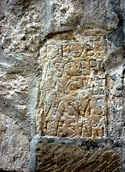
Roman Inscribed Stone by karl & Ali (Geograph).

OS Grid Reference: SD 61411 73931. In the 15th century parish church of St John the Baptist at Tunstall, near Kirkby Lonsdale, Lancashire, there is a fragment of an inscribed Roman stone, which was perhaps part of an altar but, according to the church guide, is actually a votive stone with a dedication in Latin to two Roman dieties – very roughly carved onto it; the stone was found in the 1800s at the Roman fort of Burrow (CALACVM), a couple of miles to the north. The stone was brought into the church from the churchyard in the early 20th century and was set (upside down) into a window jamb of the north aisle during restoration work. Also of interest within the church is the altar stone which is considered to be Anglian and to date from the 8th century? St John the Baptist’s church can be found along Church Lane about ¼ of a mile to the northeast of the village. The village of Tunstall itself is roughly 3½ miles to the south of Kirby Lonsdale on the A683 and 4 miles southwest of Cowan Bridge.

The Roman votive ‘altar’ stone with its Latin inscription reads: ‘DEOS ASCLEPIO ET HYGIAEAE P S SVA CVM SVIS IVL SATVRNINVS’ and when translated is something like: “To the dieties (gods) Asclepius and Hygiaea, Julius Saturninus placed This Here for himself and his family.” The word ‘SANCTO – Sacred’ can sometimes be placed at the beginning of an inscription like this as another variation.

Drawing of Roman Stone, John Cotton.

Sara Mason (1994) in her work concerning the church and parish of Tunstall tells us that “A stone in the present church is dedicated to Aesculepius, the pagan Roman god of medicine and Hygeia, goddess of healing. This was salvaged from the ruins of the Roman fort at Burrow in the eighteenth century by the Reverend Richard Rauthmell. And a fragment of another triangular Roman stone was built into a farmhouse wall in Burrow; a remaining piece was said to be in the    keeping of the vicar of Tunstall.”

Mason also adds regarding the: “Fragment of Roman votive stone: this, with a dedication to Aesculepius and Hygeia (god of medicine and goddess of healing) by one Julius Saturninus, was incorporated into the left jamb of the most eastern window of the north aisle during the 1907 restoration of the Church.”

Sara Mason (1994) adds that: “The stone of which the altar in the present church is made is considered to be Anglian (eighth century) and bears evidence of early Christian worship at Tunstall, possibly from when St Wilfred came westwards from Ripon. It was put into its present place in the 1950s. A medieval burial slab was reused and preserved, as a quoin in the old school house in the Church Lane.

The Roman road from Ribchester to Overburrow Fort runs near Tunstall Church and it is possible that an early church was built there because it was close to the road. However, churches, being on consecrated land, rarely change site. The field named Crosber — up the Church Lane, between the Cant beck and the Roman road — may refer as much to the crossing of the Roman Road by the road from Burton in Lonsdale towards the Lune, as to the possibility of a preaching cross there.”  

Lawrence E. Jones & Roy Tricker (1992) tell us a bit about the church, saying that: “Visiting a country church like this, in its delightful rural setting, stops people imagining that Lancashire is just industry and suburbia. This lovely church of St   John the Baptist was much rebuilt in 1415, but incorporates earlier work, and we enter beneath a fine two-storeyed porch, to admire 15th and 16th century glass from Flanders in the east window and much else in this atmospheric place. The medieval altar stone, cast out at the Reformation, has now been restored to its rightful use.” 

Nikolaus Pevsner (1979) describes St John Baptist Church in ‘His’ way, saying that: “The only church in North Lancashire which one can praise for never having given in to sweeping suggestions to restore windows and other features. How right Ruskin and Morris were ! It creates a human appeal which cannot otherwise be roused. The church was rebuilt by Sir Thomas Tunstal about 1415, but the W and E responds of the N arcade have early C13 capitals, and the W lancets of the aisles are probably also C13. On the N side is a two-light Dec window. The two-storeyed porch is the finest piece of the C15 work. The Perp tracery of the S aisle and the Perp arcades are coarse. — FONT. C18 stone baluster with an elliptical marble baluster. — ROMAN ALTAR to Asclepius and Hygieia (NE window sill). — STAINED GLASS. The E window has Nether-landish late C15 and C16 glass from two different sources. It was brought from Flanders by Richard T. North before 1833. — PLATE. Chalice and Paten by Richard Bayley, 1708; Paten by Henry Jay, 1709-10; Chalice inscribed 1713; Paten and Flagon by Thomas Mason, 1718-19. — MONUMENTS. Defaced early C16 stone effigy (S chapel), probably Sir Thomas Tunstal. — Many Tablets, eg. Lt. Miles North, 1837, with the relief of a shipwreck.”

Also of interest: there are several Medieval carved stones leaning against the outside wall of the church, one of which could be a cross-head, but its age is uncertain though it is possibly Anglo-Saxon?

Sources and related websites:-

Jones, Lawrence E. & Tricker, Roy, County Guide To English Churches, Countryside Books, Newbury, Berkshire, 1992. 

Mason, Sara, The Church And Parish Of Tunstall, (Drawings by John Cotton), December 1994.

Pevsner, Nikolaus, The Buildings of England — North Lancashire, Penguin Books Ltd., Harmondsworth, Middlesex, England, 1979.

Photo (top) by karl & Ali:  http://www.geograph.org.uk/photo/1992950

http://www.megalithic.co.uk/modules.php?op=modload&name=a312&file=index&do=showpic&pid=133149

https://en.wikipedia.org/wiki/St_John_the_Baptist%27s_Church,_Tunstall

https://britishlistedbuildings.co.uk/101071642-church-of-st-john-the-baptist-tunstall#.W4R9w1K0Vjo

http://cumbrianchurches.blogspot.com/2009/08/tunstall-st-john-baptist.html

https://www.tripadvisor.co.uk/Attraction_Review-g8536808-d8532119-Reviews-St_John_the_Baptist_s_Church-Tunstall_Lancaster_District_Lancashire_England.html

© Ray Spencer, The Journal Of Antiquities, 2018. 


Fairy Holes Cave, Whitewell, Forest of Bowland, Lancashire

Fairy Holes Cave by Andy Davis (Geograph)

OS Grid Reference: SD 6553 4678. On a tree-clad limestone hill above the River Hodder at Whitewell in the Forest of Bowland, Lancashire, there is a large cave or rock shelter where, from Prehistoric times, evidence of human habitation has been found. The cave is located on the south-facing slope of New Laund Hill, just to the south of New Laund farm. There are two smaller caves close by, but this larger cave proved to be of great archaeological interest back in the late 1940s, 1960s, and again in more recent years, when there were many finds including a fragment of a Bronze Age collared funery urn.   To reach Fairy Hole Cave cross over the River Hodder via the stepping stones opposite St Michael’s church, and head up beside the woods for 300m or so. There are two footpaths, the first might not be accessible, but on the second footpath at New Laund farm walk to the southwest (above the woods) for 215m; then walk down into the woodland to find the larger of the three caves on this south-sloping side of the hill, high above Whitewell and the River Hodder.

Fairy Holes Cave, Whitewell (artefacts).

Sarah Thomlinson in her work ‘Life In Bronze Age Times‘, writes about Fairy Hole Cave, saying: “This cave is situated on the south facing slope of New Laund Hill in Bowland Forest. It is 20m. long, 1.8m. wide and 3m. high. Excavations of the cave floor have shown that it was a domestic living site for prehistoric man. Some of the finds are pictured left. Among them are pottery fragments, including a piece of collared urn, which were discovered on the flat platform at the mouth of the cave. They tell us that the cave was occupied during the middle Bronze Age, 1600 — 1500 B.C. Pieces of red raddle were also found . Red raddle is a coloured clay which was used as a paint for decoration. A number of animal bones have been identified as be-longing to domesticated cattle, fallow deer and rabbit. Evidence of metal working was provided by lumps of bronze slag, the waste product from smelting . However, a stone pounder and fragments of flint show that stone working was still going on.”

The site entry ( No. 9) in the‘Lancashire Archaeological Bulletin’ (1984) for the parish of Bowland-with-Leagram. Site Name: Fairy Hole Cave. N.G.R. SD 655 468. Primary Reference: Musson 1947. Disposition of Finds: L.C.M.S. “Fragment of pottery, reconstructed by C.F.C. Hawkes as a small (7½” high) collared urn, found in excavating a limestone cave. Hawkes suggested domestic use. Illustration from Musson (left) 1947 – Plate B.” And also given is the Bibliography: Musson, R. C. (1947). A Bronze Age cave site in the little Bolland area of Lancashire: report of excavation. LCAS 59 (1947) 161 – 170. Please note Bolland should probably mean ‘Bowland’.

John Dixon (1992) does not mention Fairy Hole Cave in this volume. However, he does tell that a Roman or Bronze Age Camp used to exist opposite the Keeper’s House in Whitwell village, according to W. Thompson Watkin (1883) who referred to the earlier 1849 ‘Topographical Dictionary’ (7th Ed.) by Lewis; but that all traces of this have gone. John refers to Whitaker’s ‘History of Whalley’, adding here that that author mentions there used to be the remains of a small encampment and also a cairn of stones which contained a kist vaen and skeleton opposite the same Keeper’s House. The Keeper’s house is now the local inn. So maybe both authors were talking about same site?, John suggests.

John also adds that in 1984 a large round stone was found in the river near to the inn. On closer inspection, archaeologists declared the carved-out stone to be a mortar used for grinding food grains, and they dated it to the Bronze Age. This stone is now locally known as ‘The Whitewell Stone’, which is today housed in the hotel in the village.

Sources & related websites:-

Dixon, John & Mann, Bob, Journeys Through Brigantia  (Volume Eight) The Forest of Bowland, Aussteiger Publications, Barnoldswick, 1992.

Edwards, Margaret & Ben, Lancashire Archaeological Bulletin, Vol. 10, No. 2/3, May & July 1984.

Thomlinson, Sarah & O’Donnell, John, Life In Bronze Age Times, (A Resource Book For Teachers), Pendle Environmental Studies Group, Curriculum Development Centre, Burnley.

Photo (top) by Andy Davis:  https://www.geograph.org.uk/photo/5428095

FAIRY HOLES CAVE – WHITEWELL.

https://www.uclan.ac.uk/research/explore/projects/sheltering_memory.php

https://en.wikipedia.org/wiki/Bowland-with-Leagram

http://www.megalithic.co.uk/article.php?sid=4776

© Ray Spencer, The Journal of Antiquities, 2018.


The Wolverhampton Cross, St Peter’s Church, Wolverhampton, West Midlands

The Wolverhampton Cross, St Peter’s Church, Wolverhampton.

Information board near the cross, St Peter’s Church, Wolverhampton.

OS Grid Reference: SO 91406 98769.  Near the south door of St Peter’s Parish Church, Wolverhampton, West Midlands, stands a 4m high blackened column which is called ‘The Wolverhampton Cross’, St Peter’s Garden Cross, or sometimes Saint Wulfruna’s Cross. This curious column may, in fact, have come from the Roman town of Wroxeter, but in the mid-9th century AD Saxon stone-masons added carvings to it and, from that time on, it became a preaching cross that ‘may’ have been associated with a Saxon monastery on the site, though there seems to be little evidence for that. A small, slender stone cross used to be affixed to the top of the column’s capital. The decorative Anglo-Saxon carvings on this cylindrical shaped monument are now very faint and indecipherable, but in certain light and shade they tend to be more visible. At the north-side of the church is a modern statue of Wulfruna, a 10th century Mercian saint. St Peter’s Collegiate Church stands between the Council Offices and Wolverhampton Gallery on Wulfruna Street and St Peter’s Walk, at the north-side of central Wolverhampton, opposite the University and Arena Theatre buildings.

The Wolverhampton Cross stands beside St Peter’s parish church.

The Wolverhampton Cross, Wroxeter Roman column, St Peter’s Garden Cross or, even Saint Wulfruna’s Cross, call it what you will, is a column/pillar made of sandstone that stands just over 4 metres (13½ feet) high on its large sturdy base of four rounded steps. It cylinder-shaped shaft gradually tapers away towards the top to be surmounted by a capital where originally a cross was built onto it – and what a spectacular monument it must have been. Thought to date from 850 AD although historians now tend to think that it was carved in the late 10th century at which time (994 AD) a monastery was founded here by St Wulfruna and the original church perhaps raised to ‘minster status’, although scholars think it unlikely that there ever was a Saxon monastery. The present church is 15th century. If the column did originally come from Roman Wroxeter (Viraconium), could it have been stolen by Saxon stone carvers? – so to speak, and then brought to Wolverhampton! There are carvings on the column, although faint, of foliage, acanthus leaves, scrolls, beasts, birds and other ornament, but you’ll need to look very closely and have the right light and shade.

Robert Harbison (1993) writes that: “Outside the S door is the mid 9c Wolverhampton cross. From afar it looks like a column suffering from comically exaggerated entasis. It is very black and hard to decipher, but at the right distance you see roundels separated by decorative bands, then a subliminal lattice and, depending from it, V-shaped feelers of decora-tion which trail off into the uncarved base. It is an inventive scheme without parallel elsewhere.”

Kendrick (1938) “considered the decoration to be unique; the only surviving example in England which demonstrated the southern continental Baroque style.. He also thought (1949) that it illustrated “a taste for a crowded display of finicky decoration”, which is also reflected in the later Stapleford Cross,” according to the Wikipedia website.

Robert Harbison (1993) tells of St Peter’s Church “St Peter’s chancel is long and prominent, made that way in the 1860s by Ewan Christian to balance the 16c tower. Old photos reveal that the E end is all Victorian. Here they were right, because the 17c chancel was undeniably mean. Inside, however, we deduce the addition was planned for external effect, because from within it feels much too long.

“The nave is an awesome space, towering up to the gloom of a good roof. In the N aisle interesting Whallish windows of local provenance. On the Perp stone pulpit there’s a wonderful lion guarding the stair.

“Behind one of the mellow screens in the S transept is a compelling monument to an admiral by Le Sueur, with a mannered lifesize portrait flanked by sprawling babies, a bronze trio of enigmatic force.” 

St Peter’s parish Church with modern statue of St Wulfruna.

As to St Wulfruna, mentioned earlier, not that much is known, though she seems to have been purely a local saint; and a noblewoman of the royal house of Mercia. She was the wife of Earl Athelme, mother of St Wulfric of Burton, and granddaughter of King Aethelred I. King Edgar was related to her. Legend tells that in 948 Wulfruna was kidnapped and imprisoned at Tam-worth by the Viking chieftain, Olaf, but she did manage to escape!  Some have suggested that she founded a convent at or near the present St Peter’s Church (at the place called Hēatūn, later known as Wolverhampton), but this might not be the case. It would seem she was granted some land at Pelsall (Peoleshale) in 985. St Wulfruna died and was buried at Tamworth in 996 or 1005. There is a holy well named after her in Goresbrook Road, Wolverhampton (see link below). A modern statue of Lady Wulfruna by Wheeler stands in the square at the north-side of St Peter’s church.

Sources & related websites:-

Harbison, Robert, The Shell Guide to English Parish Churches, André Deutsch Limited, London, 1993. 

Kendrick T. D., Anglo Saxon Art to AD 900, p 192-3, 1938.

Kendrick T. D., Late Saxon and Viking Art, p 71-2 (plate XLVI), 1949.

https://en.wikipedia.org/wiki/Wolverhampton_Pillar

http://blackcountryhistory.org/collections/getrecord/WOHER_MBL337/

https://thejournalofantiquities.com/2012/08/07/wulfrunas-well-wolverhampton-west-midlands/

https://en.wikipedia.org/wiki/Wulfrun

http://www.historywebsite.co.uk/articles/wulfruna/wulfruna01.htm

https://historicengland.org.uk/listing/the-list/list-entry/1005886

http://www.historywebsite.co.uk/articles/Penn/history/AngloSaxons.htm

© Ray Spencer, The Journal of Antiquities, 2018.