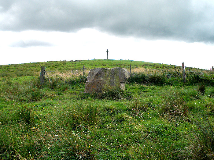
The Anvil Stone with Walton’s Spire in the background.
OS Grid Reference: SD 89391 37498. At the northwestern edge of Shelfield Hill, close to Walton’s Spire, near Nelson, Lancashire, is a large and oddly-shaped stone, which is variously known as ‘The Anvil Stone’, ‘The Altar Stone’, ‘The Druids’ Stone’ and ‘Thor’s Stone’ (Thursden Valley is not far away from here). The stone resembles an anvil or an altar at certain angles, but it also takes on the form of an animal head. It was obviously a sacred stone in the distant past and may have been venerated by our ancient ancestors. It seems to have been moved at some point. I believe this large stone (the so-called Anvil Stone) stands on an alignment with other nearby ancient sites. To reach the stone from Nelson town centre head up Barkerhouse Road (all the way), then turn (left) at the top and go along Southfield Lane as far as Gib Clough farm. Here, turn (right) up Back Lane for ½ a mile to where the land flattens out. Over to the right in the muddy field is the Anvil Stone – with Walton’s Spire in the back-ground at the top of the Shelfield plateau.

The Anvil Stone viewed from a different angle.
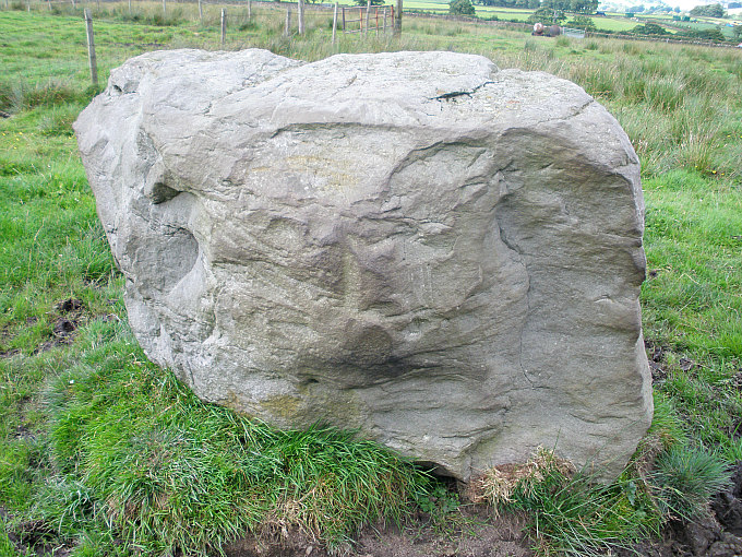
The Anvil Stone viewed from a different angle.
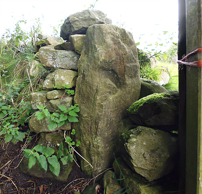
This quite large, smooth-shaped lump of sandstone, which has locally been called ‘The Anvil Stone’ because it is shaped like a blacksmith’s anvil, is between 4-5 feet high and double that or more in its girth. It is said to weigh well over a ton. The farmer did, I understand, once try to move it but it proved to be too heavy for his tractor’s lifting equipment, and so he left it where now it stands, but at some point in the past it had been moved a short distance. The stone appears to have been fashioned into the shape that we see today – be that an anvil, an altar or an animal head or, maybe the shape of a seat, according to John A. Clayton (2014). The Norse god Thor could, just as well, have given his name to this stone. His name is to be found in Thursden (Thor’s Valley) a couple of miles to the northwest, where many a thunderstorm forms in the summertime; Thor using his trusty hammer upon the anvil, hopefully not on the Anvil Stone!
The Anvil Stone viewed from yet another angle.
John A. Clayton (2006) says: “To add another feature to the equation, there is a group of stones some two-hundred metres to the south of the Spire, the largest of which I have named the Anvil Stone for the sake of descriptive simplicity, this is the only one of the group left in its original position, no doubt because its sheer weight would prevent it from being removed. The other stones have been cleared from the field and lie in a large depression in the earth (possibly an abandoned coal pit), these may have been part of a larger arrangement, such as a circle. The Anvil Stone is of particular interest, not only because it has been heavily worked to attain its shape, it also weighs about one and a half tons and is on an exact alignment with other ancient features of Black Hameldon, the tumulus at Ell Clough, Ringstone Hill and the Spire monolith.”
John A. Clayton (2014) also tells that “The photograph……….. shows why the stone was described as being shaped like a blacksmith’s anvil – from this viewpoint the similarity is clear. However, I now realize that I appear to have ‘missed a trick’ with this stone. Firstly, I think that I was viewing it from the rear and secondly the stone is actually not in situ. As always, local knowledge is an invaluable asset in historical and archaeological research and so it proved in this case.
“The Shelfield Hill farmer informs me that the stone was originally buried in the field about 250 metres to the north-west of where it is now located. Around twenty years ago the field was being re-seeded and the shallow plough persistently hit stones beneath the surface. These were dug up and moved up the hill to be piled on the edge of the soakaway – the largest stone was placed separately to this group and this is the reason why the ‘anvil’ stone is situated where we now see it.”
John goes on to say that: “It further struck me that not only was I possibly viewing the stone from the back, I was also looking from the wrong angle. When the stone is viewed from a ninety-degree angle it strongly resembles a seat or chair. This might sound somewhat far-fetched but, in defence of my sanity, the stone has been heavily worked on all of its faces – the ‘front’ face in particular having been sculpted into the profile………”
John adds: “From what can be seen of the neighbouring boulders there is no evidence of them having been worked; they appear to be typical of the stones utilized in field boundaries and hut foundations. The size and shape of the massive block clearly lent itself to being shaped into its present form; whether it was intended to function as a seat is, of course, pure speculation and, as we shall see later, there could be other possible contexts here.”
Walton’s Spire or Walton’s Monument, a well-known landmark to the northeast of Anvil Stone, is a Victorian four-armed cross set upon a 10th century menhir or monolith, which became known as ‘the Battle Stone’. This was eventually carved, as we see it today, by workmen employed by Richard Roe Walton of Marsden Hall, Nelson, in 1835. See the link, below.
Sources and related websites:-
Clayton, John A., Valley of the Drawn Sword — The Early History of Burnley, Pendle and West Craven, Barrowford Press, 2006.
Clayton, John A., Burnley And Pendle Archaeology — Part One — Ice Age to Early Bronze Age, Barrowford Press, Spring 2014.
http://www.megalithic.co.uk/article.php?sid=25255
© Ray Spencer, The Journal of Antiquities, 2018.