The Journal Of Antiquities

Ancient Sites In Great Britain & Southern Ireland


The Washington Family Coat-of-Arms Stone at St Oswald’s Church, Warton, Lancashire

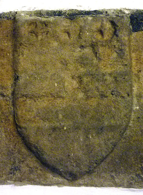
Washington coat of arms, Warton Church by Karl & Ali (Geograph).

NGR: SD 49819 72316. On Main Street at the southwest side of Warton village, near Lancaster, Lanca-shire, is the 14th Century church of St Oswald, and housed inside is a heavily-worn stone plaque or shield which used to show the Washington family’s Coat-of-Arms; this very worn stone has become a place of pilgrimage for visiting American tourists. The stone was originally on the outer (west) wall of the church-tower, but because of the vulnerability to the carving from weather-related erosion in 1955 it had to be placed on the tower wall inside the church, and now has a glass cover over it. This, then, (the) Washington Family Coat-of-Arms is generally believed to be the source of the ‘Stars and Stripes’ emblem of the United States flag. Robert de Washington was (of a branch of the Washingtons of County Durham) and he settled in Westmorland in the late 15th Century, and later owned land at Warton.  It was from this branch of the Washington family that George Washington was descended.  Robert de Washington of Warton was a generous benefactor to the village church and also had the stone plaque   or shield placed on the exterior tower wall. 

Washington shield at Warton Church, Lancs.

Sydney Moorhouse (1958) says that: “Here, on the outside of the western wall of the fifteenth century tower is a stone shield greatly worn by the weather, displaying the armorial bearings of the Washington family — “Arg. 2 bars, Gul, 3 mullions of the 2nd, with crescent for difference” which according to Lucus, the Warton historian of the early eighteenth century, ‘“is a plain indication that this family, ancient and yet creditable in the town, where the Rev. Laurence Washington has a good estate, have been largerly contributory towards the building of this fabric”’. It is generally believed that this coat of arms was the source of the Stars and Stripes emblem of the United States.

“The Washingtons originated from a small village named Wessington, in County Durham, and even to-day there are Old Washington and Washington marked on the maps of that county. A branch of the family settled in Westmorland and eventually came into the possession of lands around Kendal and in the vicinity of Warton. It was from the branch that George Washington was descended.

“Towards the end of the fifteenth century, one Robert de Washington, according to Mr. T. Pape’s excellent little publi-   cation on ‘“George Washington’s Ancestors and Their Memorials in England”’, held the lordship of Tewitfield in the    Manor of Warton by Knights Service and fivepence yearly instead of doing his duty at Lancaster. This same man owned fifteen burgages in Warton and ‘“in all probability the Washington Coat of Arms carved in stone on the outer western wall of Warton Church tower was a record of this Robert Washington’s generosity in the building of a Church”’.

Moorhouse goes on to say that: “It was the grandson of this Robert Washington who married a member of the Kitson family, who had large estates in Northamptonshire, and his son Laurence left Warton in the reign of Henry VIII for Northamp-tonshire and later settled at Sulgrave Manor. These were the ancestors of the illustrious George. Need I continue the story? I do so to show that the line of ancestry is unbroken and quote from a description of Sulgrave in ‘“English Country Houses”’ by Ralph Dutton and Angus Holden:

‘“Laurence Washington died in 1584 and was buried in the parish church. He was succeeded by his son       Robert, who in 1610 sold the Manor to his nephew, Laurence Makepeace.  It was in 1657, during the Commonwealth, that John Washington, great-grandson of Robert, sailed to America and settled at           Bridges Creek, Virginia, where the famous great-grandson, George Washington, was born in 1732.”’

“Although the main branch gravitated to Northamptonshire, some Washingtons remained in Warton until just over a century ago. Lucas refers to one in his History. The last was Thomas, who was vicar from 1799 to 1823 and is buried there. 

Maxwell Fraser (Miss) writing in 1939, says: “There is a closer link with America at Warton, about a mile from Carnforth which, although not actually in the Lake District, is within easy reach of Grange, either across the sands, or by the road round the head of the estuary. There was a branch of the Washington family settled at Warton centuries ago, and the arms of Robert Washington were carved on the tower of Warton church, where they are now protected from the ravages of weather and tourists by a sheet of glass. Lawrence Washington left Warton in the reign of Henry VIII for Northampton, and later settled at Sulgrave, but a branch of the family remained at Warton, and Thomas, the last of the Warton Washingtons, was vicar from 1799 to 1823 and is buried there.”

Miss Fraser adds that in St Martin’s church at Bowness-on-Windermere, Cumbria: “………every American visitor is attracted by the stained-glass panels in the east window (top) which show the arms of the Washington family.” This would be the crest/shield of George Washington, who became the 1st President of the United States of America in 1789, and whose ancestor one John Washington of Warton, had it placed here in the 15th Century.

And, finally, Pevsner (1979) tells us more about Warton church, saying: “St Oswald. The oldest evidence is early C14: the S chapel Sedilia (pre-1300?), the s arcade, if it represents original evidence (it is C19), and a S aisle window. Perp W tower, chancel, and N arcade . — In one PEW set-in shields — from older bench ends? — TWO BENCH ENDS, dated 1571 and 1612, are in the vestry.* — FONT. The base is typical of 1661, its date in the one elementary geometrical pattern. Also dated 1661 the lead interior, and this has much finer, indeed very delicate, patterns. — PLATE. Unmarked Chalice; Paten of 1716 by S.L.; Flagon inscribed 1802.”

Sources / References & Related Websites:-

Fraser, Maxwell (Miss), Companion Into Lakeland, Methuen & Co. Ltd., London, (Second Edition) 1939.

Moorhouse, Sydney, Twenty Miles around Morecambe Bay — a Guide To Local Beauty Spots & How To Reach Them, The Morecambe Bay Printers Ltd., (Fourth Edition) 1958.

Pevsner, Nikolaus, The Buildings of England — North Lancashire, Penguin Books Ltd., Harmondsworth, Middlesex, (Reprint) 1979.

Photo (top) by Karl & Ali: https://www.geograph.org.uk/photo/4555166

https://en.wikipedia.org/wiki/Warton,_Lancaster

https://en.wikipedia.org/wiki/Coat_of_arms_of_the_Washington_family

https://en.wikipedia.org/wiki/George_Washington

https://en.wikipedia.org/wiki/Flag_of_the_United_States

https://www.lancashirelife.co.uk/out-about/places/the-george-washington-connection-to-the-north-lancashire-village-of-warton-1-2370404

More info here: https://bitaboutbritain.com/imagine-if-george-washington-had-been-lancastrian/

© Ray Spencer, The Journal of Antiquities, 2020.


Lexden Burial Mound (Tumulus), Near Colchester, Essex

Old Map of Colchester and Lexden Areas with Tumulus & Celtic town.

NGR: TL 97537 24712. In the back gardens of a row of houses on Fitzwalter Road at Lexden, 1 mile southwest of Colchester town centre, in Essex, is an ancient barrow (tumulus) with trees growing out of it. The area where the mound is located was originally called Lexden Park. It was con-sidered by historians and antiquarians to date from the late Iron Age period of pre-history and, probably constructed just before, or at, the Roman occupation of 43 AD. Traditionally, it has also been thought that the mound was where the British prince, Cunobelinus, was buried, although whether there is any truth in that remains to be seen. Colchester was originally called Camulo-dunum after Cunobelinus, King of the Catuvellauni. To the north of the tumulus is the site of a Celtic cemetery and, further to the northeast at Sheepen Farm the site of the Celtic town, which would have been inhabited in the time of Cunobelinus. When the tumulus was excavated in 1924 many artefacts were dis-covered, some of which were bronze. The 4-5 foot high barrow with its outer ditch is at the far south-western end of Fitzwalter Road (Handford Place), just before St Clare Road.

Benham’s (1946) tells of the site, saying: “The Lexden Tumulus is a burial mound situated in what was formerly Lexden Park, and was excavated in 1924. It has long been a local landmark, in fact Dr. William Stukeley (1687-1765) had noted it in 1758 as ‘“Prasutagus’s grave,”’ a fanciful and unfounded ascription. Morant, though not mentioning the mound in his History of Colchester, left a plan of it with manuscript notes. The Rev. Henry Jenkins (c.1860) called it a ‘”Beacon,”‘ regarding it perhaps as a mount or mound in the vicinity so described in Speed’s Map of Essex (1610). Roman remains were found in the mound in 1860 (an amphora and pottery). Though surrounded (at some distance) by a circular ditch the mound itself was ovoid in shape.”      

Lexden Burial Mound (Tumulus) bronze artefacts.

Benham’s goes on to say that: “The excavation in 1924 indicated that the mound was the burial place of some noted personage, probably before the Roman Conquest in A.D. 43. The objects discovered included : (1) fragments of burnt human bones; (2) fragmentary pottery, described as ‘“pre-Flavian,”’ or, at latest, of the first half of the first century; (3) masses of iron, of which several portions are apparently parts of a litter; (4) iron chain-mail (many fragments); (5) a bronze table about 13 in. long by 9¾ in. broad and about 3¼ in. high, standing on four small ball-footed legs, and adorned with pendent scroll-work (it is thought that this table may have been the base of a standard lamp); (6) bronze pedestal about 3½ in. square and 2 in. high; (7) small bronze foot, sandalled (part of a figure of which the remainder was not found); (8) bronze figure of Cupid, holding a bird, found near the pedestal; (9) neck and head of a bronze griffin originally the attachment (or handle) for a bowl; (10) a small bronze bull, lying down; (11) a small bronze boar (tusked); (12) other bronze objects and fragments, bosses (with traces of red enamel), large numbers of bronze studs of various sizes, some of which are supposed to have decorated harness, a bronze palstave (an implement or weapon devised  to fit in to a wooden handle, dating from the late Bronze Age, already at least 900 years old at the time of burial), etc.; (13) remains of leather clothing, with a buckle; (14) fragments of horn; (15) remains of fine gold tissue; (16) many trefoil-shaped silver ornaments, remains of silver buckles and silver studs; (17) silver medallion with head of  Augustus (Gaius Octavius, 65 B.C.—A.D. 14) said to be identical with that on denarii issued 17 B.C., cut out from an actual coin and soldered on a silver disc, enclosed in moulded silver frame. It is inferred that this must have been the burial of a personage of importance, and it has even been supposed that it may have been the funeral mound of Cunobelinus, the British King. The absence of all coins of Cunobelinus is significant.”       

Benham’s adds more, saying that: “Colchester has claims to be the oldest recorded town in Great Britain. It occupies the site of the British Camulodunum, the ‘“fort of Camulos,”’ the Celtic war god, and the “‘royal seat”’ or capital of the British King Kunobellinos, according to the historian Dio Cassius. The coins of Cunobelinus, with their legends CAMV for Camulodunum and CVNO for Cunobelinus, found in hundreds in Colchester, are substantial evidence in conformation of this statement.

“Cunobelinus is the Cymbeline of Shakespeare, though beyond the name the poet borrowed nothing of his story—either legendary or historical. Cunobelinus resigned from about 5 B.C. till his death about A.D. 43. He is described on his coins as son of Tasciovanus, whose coinage is also plentiful, and who was perhaps descended from Cassivellaunus (Caswallon), who resisted Julius Cæsar’s invasion of Britain in the year 54 B.C. Cassivellaunus made terms with the Romans and continued to reign after there departure. He is reputed to have seized Camulodunum about 50 B.C., taking it from Man-dubratius, who was restored to his sovereignty by Julius Cæsar. These latter details, however, cannot be accepted as authentic.

“The Celtic settlement was discovered to be a large area of wattle-and-daub huts, dotted over the hill now occupied by Sheepen Farm, from the river marshes on the north up to the plateau towards the south, very much in the manner of native ‘“kraals”’ in Africa. Great quantities of pottery were found, as well as moulds for the striking of Cunobeline’s coins. The pottery included native (British) ware and Roman ware imported from the Rhineland, N. and S. Gaul, and Italy. Brooches and bronze objects and coins were also discovered. The coins were mainly of Cunobelinus, but one of his predecessor, Tasciovanus, was unhearthed. Over 50 Roman coins were found, ranging up to Claudius (A.D. 41—54). The evidence showed that the Celtic site had been occupied by the Roman soldiers for many months, or even a few years, before the Roman Colony had been established to the S.E., thus changing the position of the town to that which it now occupies on the hill adjoining.

“The Celtic cemeteries were on the south side of the main settlement, many burials having been found in the Lexden Park area. Several lines of massive earthworks, including Gryme’s Dyke, protected Camulodunum on the west, running from the river Colne in the north to the Roman river in the south, thus cutting off the peninsula formed by those two rivers.”

Hawks (1975) regarding Colchester, says: “The town stands, as it were, at the junction of British history with prehistory. Cunobelin or Cymbeline, who united south-east Britain into a single powerful kingdom during the early years of our era, established his capital here in about 10 A.D. He chose a slope above the Colne just to the south-west of the present town at a place where now there is little for the visitor to see beyond a huge notice by which the Corporation have obligingly announced that this is the site of Camulodunum, capital of King Cymbeline. The outer dykes defending the settlement —comparable to those we have seen at Chichester and St. Albans……are still visible within the area of Lexden Park. These long lines of bank and ditch are typical of Belgic military ideas in contrast with the enclosed hill-fort of their immediate predecessors. The faint remains of the scattered city of Camulodunum are now under fields, houses and roads on the outskirts of Colchester. Excavation showed that Cunobelin, and after him, no doubt, his ill-fated sons ruled there until the time of the Roman conquest.” 

Darvill (1988) telling of the inhabitants of Camulodunum, says: “The Lexden Tumulus………contained the burial of one of their leaders, possibly King Addedomaros. Accompanying the cremation were many ritually broken objects including fine tableware, wine amphorae and jewellery. Following the Roman Conquest, Camulodunum became an important colonia for retired Roman army veterans.”

Priestley (1976) tells us Colchester is: “One of the earliest Roman towns to be founded in Britain. Colchester has a great deal to show the visitor. In days before the Roman conquest, Cunobelinus (Cymbeline) King of the Catuvellauni ruled the whole of SE England from his capital here. It was situated on flat land to the W and NW of the modern town and defended by an elaborate system of earthworks and dykes between 2 and 3 miles (3.2 and 8 km) distant from the town. Traces of these may still be seen and followed with the aid of an Ordnance Survey map.”

There is a second tumulus, though this one is not so well known, 665m to the northwest of the Lexden burial mound, on a grassy area in the middle of a modern housing estate (Marlowe Way) at NG: TL 96877 24882. This tumulus, known as ‘The Mount’, probably dates from around the same time as the one at Fitzwalter Road, Lexden.

Sources / References & Related Websites: 

Benham’s, Benham’s Colchester — a history and guide, Benham And Company Limited, Colchester, 1946.

Darvill, Timothy, AA Glovebox Guide — Ancient Britain, The Publishing Division of The Automobile Association, Basingstoke, Hampshire, 1988.

Hawkes, Jacquetta, A Guide To The Prehistoric And Roman Monuments In England And Wales, Cardinal (Sphere Books Ltd), London, 1975.

Priestley, Harold, The Observer’s Book of Ancient & Roman Britain, Frederick Warne & Co Ltd., London, England, 1976.

https://en.wikipedia.org/wiki/Lexden

https://colchesterheritage.co.uk/monument/mcc1356

https://historicengland.org.uk/listing/the-list/list-entry/1019967

https://www.heritagegateway.org.uk/Gateway/Results_Single.aspx?uid=MEX34083&resourceID=1001

https://megalithix.wordpress.com/2009/12/20/lexden-tumulus/

© Ray Spencer, The Journal of Antiquities, 2020.