The Journal Of Antiquities

Ancient Sites In Great Britain & Southern Ireland


Hades Hill Barrow, Near Whitworth, Rossendale.

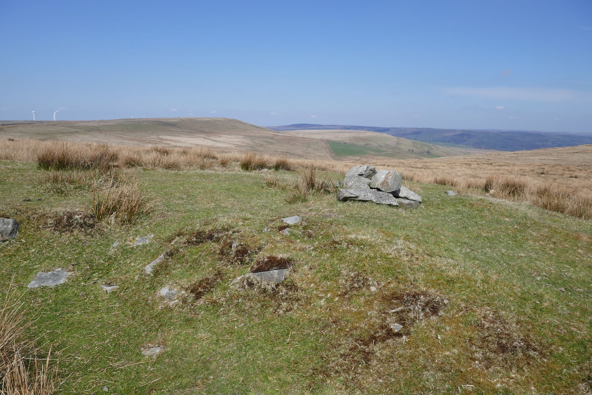
Hades Hill Barrow and more recent cairn. Photo is courtesy of Stephen Oldfield.

NGR: SD 9082 2010. Hades Hill is 3 miles to the east of Shawforth, near Whitworth, in Rossen-dale.  Roughly about halfway between Hades Hill  and Rough Hill  and close to the footpath running northeast there is a Bronze Age barrow or cairn, though it is not easy to make out today as nearby there are a number of bell pits and mounds caused by past mining and quarrying operations. The barrow is today marked by a stone cairn – these stones most likely coming from the burial cist at the centre of the low mound. In 1982 the barrow was excavated by (GMAU) Manchester University,  but they didn’t say what they found and they left the barrow in a pretty bad state.  However, it was excavated further back in 1898 and their findings were published, thankfully. Hades was the Greek god of the Underworld, so this place is known as “The Hill of the Underworld”, a very apt name indeed. There are also a group of barrows on the western slope of the hill and a large cairn, or cairn circle, on the summit that was described by the 19th century antiquarian, T. D. Whitaker, as a beacon. From Facit take the footpath for 3 miles heading E, then NE, to reach a track also going NE halfway between Hades Hill and Rough Hill – the barrow is at the N side of the track, next to some bell-pits.

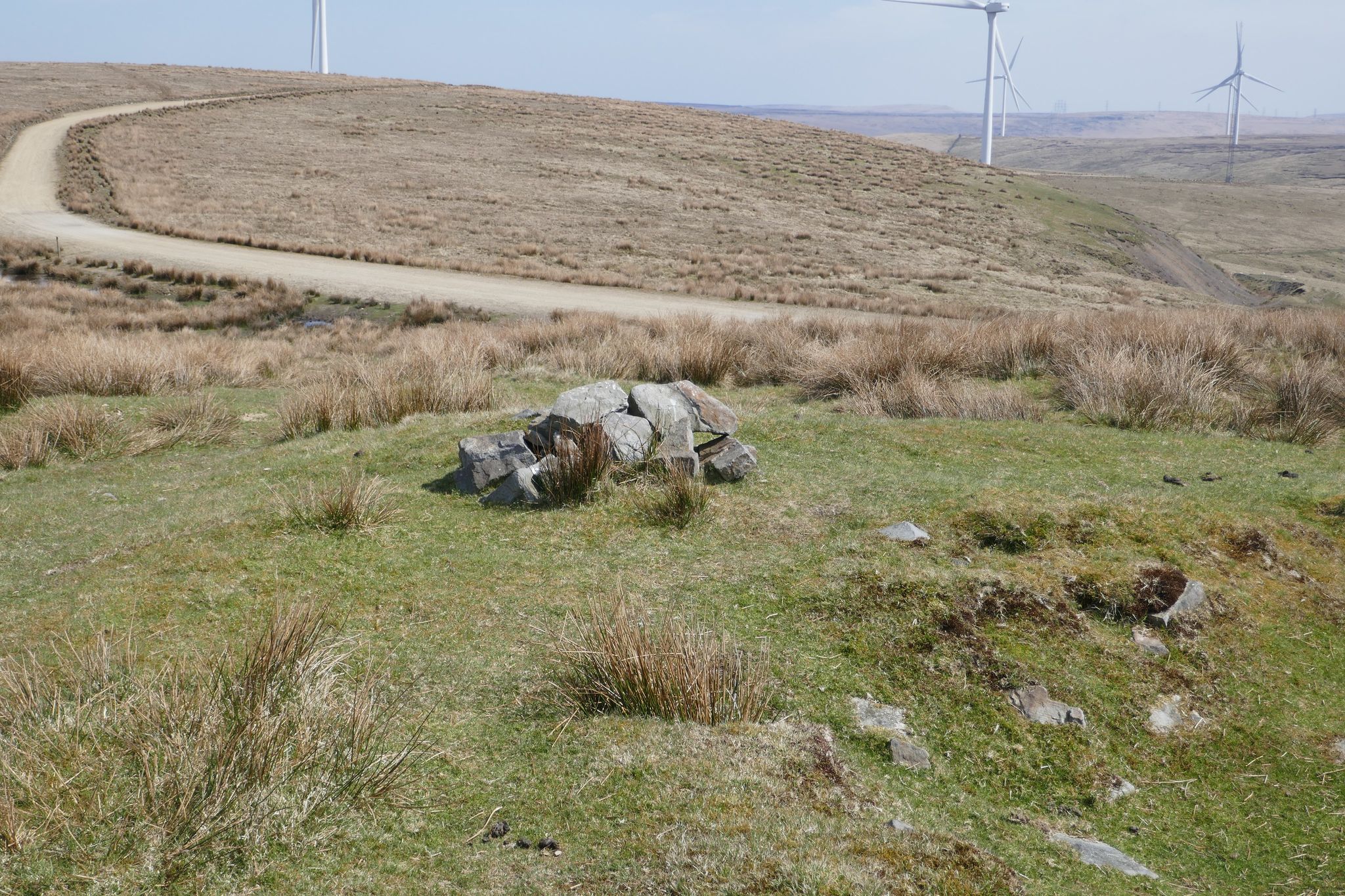
Hades Hill B.A. Barrow.  Photo is courtesy of Stephen Oldfield.

The Hades Hill barrow is 15 metres long and 134 wide, with evidence of the excavations back in 1898 and 1982, and it overlooks an ancient settlement. It is situated on the west side of the depression between Hades Hill and Rough Hill, above Whitworth, and close to the road to Crook Hill Wind Farm. Excavated in 1898 by Mr J.T. Hill of Shawforth, in appalling weather conditions, it contained an inverted urn over the cremated remains of a female, with a barbed arrow head, a flint scraper, a finely pointed borer, animal bones and charcoal. The urn and its contents are now in the archives of the Touchstones museum, Rochdale. Hades Hill literally means ‘hill of the dead’ and there are depressions nearby which were thought to be late medieval coal mining, but may actually be Bronze Age ‘pit’ dwellings. A fascinating area with incredible views and not a soul in sight, says my friend Stephen Oldfield, who has researched this area.

“All online resources give a slightly different grid reference for Hades Hill Barrow.  Having studied the maps and the accounts – and been up there – this is the barrow – with evidence of a quarter of it being dug out.  It looks like stone dug at the recent 1982 excavation has been used to build a cairn nearby.  It’s a great site – lined up with Knowl Hill, Hamer Hill SW, Blackstone Edge SE  and Broadclough Dykes/Hogshead Law NW with the basin stone at Todmorden at NE. Cleverly situated”, says Stephen.

“This small, low barrow or cairn — a couple of miles north of the little-known Man Stone — measures 15 metres north to south, 13 metres east to west and is 0.9 metres high (about 3 feet in height)” – The Northern Antiquarian.

There is a site page in “Lancashire Archaeological Bulletin”, Vol. 10, No. 2/3, May and July, 1984. This says: “PARISH: Wardle. SITE NAME: Hades Hill. N.G.R. SD 908 202. PRIMARY REFERENCE: *Sutcliffe 1900. DISPOSITION OF FINDS: Barrow, excavated December 1898. Contained urn with cord decoration in chevrons, burnt human bones, burnt flint implements, burnt flint flakes and “a broken nodule of jasper flint” (?) Central cairn and peristalith. Further excav. 1982 by GMAU.” *On page 29 of the Bibliography it adds: “Sutcliffe W.H. (1900) Hades Hill Barrow. Trans. Rochdale Lit. & Sci. Soc. 6 (1900) 56-63).”

There is also a circular feature on the summit of Hades Hill, which looks like a round barrow or cairn circle. Described as a circle within a circle by Stephen Oldfield. However, the noted Antiquarian Thomas Dunham Whitaker (1759–1821) described this as a beacon. On the western slope of the hill there’s a group of round barrows that can be seen on aerial views and as circular, grassy mounds at ground level. This is probably a Bronze Age cemetery.

The circular feature on the summit of Hades Hill, which might be a cairn circle or maybe a beacon. Photo courtesy of Stephen Oldfield.

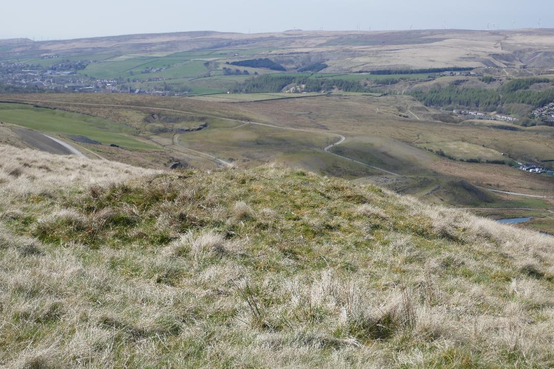
One of several Bronze Age barrows on the western slope of Hades Hill, near Whitworth. Photo is courtesy of Stephen Oldfield.


Sources & References & Related Websites:-

Many thanks to Stephen Oldfield for the use of his photos and for the information he has provided. These photos are Copyright © Stephen Oldfield 2021.

Edwards, Margaret & Ben, Lancashire Archaeological Bulletin, Vol. 10, Nos. 2/3, May & July, 1984.

Hades Hill, Whitworth, Lancashire – (thenorthernantiquarian.org)

Prehistoric – Archaeological Discoveries in South-East Lancashire (wordpress.com)

Whitworth – Archaeological Discoveries in South-East Lancashire (wordpress.com)

Copyright © Ray Spencer, The Journal of Antiquities, 2021.


1 Comment

Stoney Littleton Long Barrow, Near Wellow, Somerset

Plan of Stoney Littleton Long Barrow, Som.

NGR: ST 73494 57213. On a steep hillside just to the east of Littleton Lane and ¾ of a mile southwest of Wellow, in Somerset, is the ‘Stoney Littleton Long Barrow’, a gallery-grave monument dating from the Neolithic period (3700 to 3500 BC), which was built in the Cotswold-Severn tradition; this barrow being the northern-most of the series. It is also known as Bath Tumulus and Wellow Tumulus. In 1858 it had to be restored following damage caused by the robbery of stones almost one hundred years previously from inside the mound, but, it had been properly excavated before that in 1816-17 when a number of finds were found including bones, some of them burnt; these artefact were later deposited in the Bristol City Museum. There are seven burial chambers inside the barrow including the one at the far end of the 13 metre long passageway or gallery which is reached through the entrance and vestibule! The monument is in the care of English Heritage. You can reach the site from the south. From Stoney Littleton walk NE on the footpath for a mile, then head NW along the Limestone ridge for a short while to the monument, which is in front of you, or park in the small carpark opposite Stoney Littleton farm, and join the foot-path.

Timothy Darvill (1988) tells us that it is: “Approached across fields from the south along a signposted path, this Neolithic long barrow was constructed in the Cotswold-Severn tradition about 3700 BC. The cairn, edged by a neat drystone wall, measures about 30.5m long by 15.2m wide at the south-eastern end. At the front are two projecting horns flanking a forecourt, in the back of which is the entrance to the chambers. As you enter the chamber look for the cast of an ammonite fossil on the left-hand door jamb. The burial chambers, which occupy only a small proportion of the mound, open from a central passage — three on each side and an end-chamber. When excavated, these chambers contained confused heaps of bones representing many individuals. Details of the burial rites at other Cotswold-Severn barrows suggest that corpses were first placed in the entrance to the passage and that later, as each body decomposed, it was moved further into the passage until ultimately, as dry bones, it was left to rest in one of the side chambers. The construction of the chamber and passage is of interest, not only because of the techniques used — upright wall stones carrying a partly corbelled roof — but also because the stones themselves were brought to the site from outcrops over 5 miles away.” 

Jacquetta Hawkes (1975) says that: “By far the most important of the northernmost of the group, the chambered long barrow of Stoney Littleton which lies on a hill slope three-quarters of a mile south-west of Wellow church. Like Fairy Toot, this is an outlier of the finest and supposedly earliest type of the Cotswold megalithic barrow; like them the imposing entrance portal is approach-ed through a forecourt, or recess, in the large end of the mound, and itself leads into a passage with cells opening off it on either side. Here at Stoney Littleton there were six side cells in all, skilfully built of megalithic uprights packed with drystone walling and with a roughly but effectively corbelled roof. Although it was plundered of its skeletons and grave-goods in the eighteenth and early nineteenth centuries,  the architecture is itself unusually complete,  and other than the Cotswold Hetty Pegler’s Tump there is nowhere in England or Wales where one can better experience the ancient character of these earth-fast sepulchres, where the bodies of the Stone Age dead were returned to the Great Goddess.”  

Janet & Colin Board (1991) add to the above, saying: “A low passageway penetrates almost halfway into the 100-foot mound, and this is therefore a particularly exciting burial chamber to visit, not recommended to the claustrophobic! (Take a torch, there is no light inside.) Three pairs of chambers lead off the passage, and burnt bones have been found, with fragments of an earthen vessel. A stone with a fine fossil ammonite cast was used to decorate the entrance, its beauty obviously being appreciated by Neolithic man; but did they realise its age and the means whereby it was formed?” 

The HE (Historic England) list entry no is:- 1007910. See Link, below.

Barrow at Stoney Littleton Somerset – Section And Plan. Taken from ‘The Story of Prehistoric and Roman Britain – Told in Pictures’ by C. W. Airne, M.A. (Cantab.), Sankey, Hudson & Co. Ltd, Manchester.

Transverse Section of Gallery And Chambers, Stoney Littleton, Som. From ‘The Story of Prehistoric and Roman Britain’ – Told in Pictures’ by C. W. Airne, Sankey, Hudson & Co. Ltd, Manchester.


Sources / References & Related Websites:-

Airne, C. W., The Story of Prehistoric and Roman Britain — Told in Pictures, Sankey, Hudson & Co. Ltd., Manchester, 1935.

Board, Janet & Colin, Ancient Mysteries of Britain, Diamond Books (Harper Collins Publishers Ltd., 1991.

Darvill, Timothy, AA Glovebox Guide — Ancient Britain, Publishing Division of The Automobile Association, Basingstoke, Hampshire, 1988.

Hawkes, Jacquetta, A Guide To The Prehistoric And Roman Monuments In England And Wales, Cardinal (Sphere Books Ltd.,), London, 1975.

Stoney Littleton long barrow, Wellow – 1007910 | Historic England

Stoney Littleton Long Barrow | English Heritage (english-heritage.org.uk)

Stoney Littleton long barrow, Wellow, Bath and North East Somerset (ancientmonuments.uk)

Stoney Littleton Long Barrow – Wikipedia

Stoney Littleton Long Barrow (Archeological site) • Mapy.cz

Photo by Rick Crowley:  Entrance to Stoney Littleton Long Barrow © Rick Crowley :: Geograph Britain and Ireland

Copyright © Ray Spencer, The Journal of Antiquities, 2021.


St Faith’s Church, Llanfoist, Monmouthshire (Sir Fynwy), Wales

Llanfoist. Church of St Faith, Monmouthshire by Alf Beard (Creative Commons 2.0).

NGR:- SO 28588 13227. At the western edge of the village of Llanfoist near Abergavenny, in Monmouthshire, is the lovely little church of St Faith, a 19th century Gothic style building, but with some 13th century stonework remaining. Originally it was dedicated to St Ffwyst, a Welsh saint of the 6th Century, about whom next to nothing is known. She, or he, was also known as Foist, hence the name of the village, but the Latin name was probably Fausta. It is thought the saint was born on the Island of Anglesey. However the present dedication, perhaps through lack of any reliable information on St Ffwyst’s life, is to Saint Faith or Foy, a virgin and martyr under the Romans at Agen in France (304 AD), which was near the end of the reign of the Emperor Diocletion. The village name is sometimes given as Llanfoist Fawr, so could there be another Llanfoist or Llanffwyst somewhere else in Wales or on the Island of Anglesey? However, “it would seem that St Ffwyst was a priest of the monastic college of Seiriol, a saint who lived in Anglesey in the 6th century”, according to Chris Barber (1992). In the circular churchyard of St Faith’s there is the shaft and base of a medieval preaching cross, and an obelisk marks the grave of Crawshay Bailey Esquire, the 19th century ironmaster and industrialist of Nantyglo. St Faith’s Church is at the junction of Llanellen Road and the B4246 (Merthyr Road), just a little to the north of the Brecon & Abergavenny Canal.

Eiddil Eiddil (Thomas Evan Watkins) writing in 1834 tells us that: “The parish of Llanfoist extends from the banks of the Usk to the banks of the Torfaen, and is surrounded by the parishes of Abergavenny, Llanwenarth, Llanelly, Aberystruth, Trevethin, Llanelen, &c. There are some who believe the name (Llanfoist) to be derived from Llan and ffos, or Llan (Church) in the trench or marsh. Others (such as Willet in Stranger in Monmouthshire, 46) think it is Llanfoyle, whilst others still ask if there is no better derivation than either of the above names, and whether it cannot be derived from Llan and Faustus (Latin), that is to say, the lucky or prosperous church. Or it may be from Fausta, the daughter of Gwrtheyrn Gwrthenau by his first wife (Warrington, 63) and if so it may be inferred that this church was built at or about the beginning of the 6th century (Welsh saints, 86), although I am not aware that it has any register older than other churches. When historical researches are made (see William’s History of Monmouthshire, app. 194) we find the family of one William’s of Llanfoist descended from the lineage of Caradog Fraich Fras, Earl of Hereford, the Prince and owner of the fine territories between the Wye and the Severn, Lord of Dolorous Castle, and a Baron of the Order of the Round Table in the Time of King Arthur. And that one Gwgan ap Blethin ap Maynarch, Lord of Brecknock, married Gwenllian, the daughter and heiress of Phillip ap Gwys, Lord of Wiston, and I believe the Church was built in the time of Gwgan ap Blethin, as a token of regard for her grandfather (Viz. The Grandfather of Gwgan’s wife). It was easy to change Gwys into Ffwys, and corrupted more and more by others, doubling the F, so that scarcely anybody seeing the spelling of the word today by the Welsh and English would imagine that it had any connection with Gwys (Llanfoist !!).”

St Faith’s. Llanfoist Churchyard Cross by Jeremy Bolwell (Creative Commons 2.0).

St Faith’s parish church stands in the shadow of the Blorenge Mountain, which is 1,841 feet high. In the churchyard there is a late Medieval preaching cross. The thin octagonal pillar, which possibly replaced an earlier shaft, stands to a height of just over 2 metres and tapers away towards the top. This is built into a chunky socket-stone, which is atop four ashlar-built steps; at the sides of the socket-stone there are curved stone stops. The steps are much older than the pillar; the largest step at ground level is cut-away at an angle – and the stepped arrangement is pyramidal in shape. Also in this churchyard is a tall granite obelisk marking the grave of the iron-master and industrialist of Nantyglo, Crawshay Bailey Esquire (1789 – 1872). “He owned ironworks and coal mines and was a railway pioneer in the Cynon Valley”, says Alun Roberts (2002). Some of the stained-glass windows inside the church are dedicated to the memory of Bailey, whose son greatly restored the church back in 1877 in memory of his father. Bailey Snr. had the Abergavenny town-hall clock built and also gave Bailey Park to the people of the town. There are yew trees in the churchyard which could well date back hundreds of years, although one that was 1,000 years old, sadly, came down in high winds in 2012.

Sources / References & Related Websites:-

Barber, Chris, The Seven Hills of Abergavenny, Blorenge Books, Abergavenny, Gwent, 1992.

Barber, Chris, Exploring Gwent, Regional Publications (Bristol) Limited, Clifton, Bristol and Abergavenny, Gwent, 1984.

Eiddil Ifor (Thomas Evan Watkins), Hanes Llanfoist, (Transcribed And Footnotes Added By Colonel J.A. Bradney, C.B.), First published 1998 in association with the Llanfoist & Distrct Historical Society, Blorenge Books, Llanfoist, Abergavenny, Gwent, in this edition Chris Barber.

Roberts, Alun, A Pocket Guide — Discovering Welsh Graves, University of Wales Press and The Western Mail, 2002.

Geograph Photo by Alf Beard:  St Faith Church, Llanfoist © Alf Beard cc-by-sa/2.0 :: Geograph Britain and Ireland

Geograph Photo by Jeremy Bolwell:  File:St Faiths, Llanfoist, Churchyard cross – geograph – 3199908.jpg – Wikipedia

Parish Church of St Faith, Llanfoist, Monmouthshire (britishlistedbuildings.co.uk)

St. Faith’s Churchyard Cross, Llanfoist, Llanfoist Fawr (Llan-ffwyst Fawr), Monmouthshire (Sir Fynwy) (ancientmonuments.uk)

Llanfoist (mongenes.org.uk)

| News | Abergavenny Chronicle

Vortigern ap Gwidol, High King of Britain (c.385 – d.) – Genealogy (geni.com)

Saint Faith – Wikipedia

Copyright © Ray Spencer, The Journal of Antiquities, 2021.