The Journal Of Antiquities

Ancient Sites In Great Britain & Southern Ireland


The Noggarth Ridge Stone, Near Wheatley Lane, Lancashire

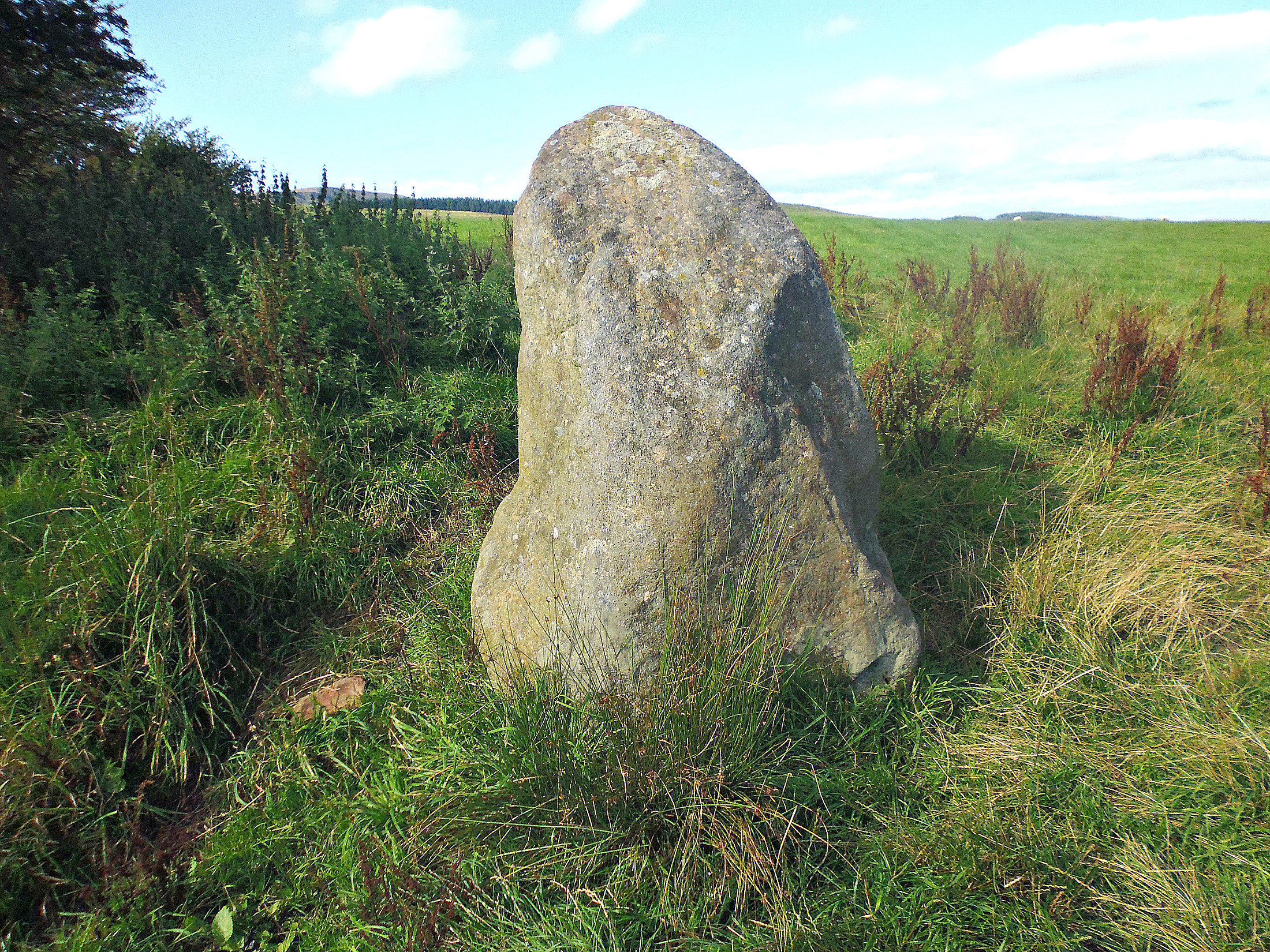
Standing Stone on Noggarth Ridge above Wheatley Lane.

NGR: SD 81786 37861. A standing stone-cum-boundary stone located on the Noggarth Ridge above the village of Fence (Wheatley Lane) near Padiham, in Lancashire. The 6 foot high gritstone boulder is situated beside a footpath and is roughly halfway between Croft Top Lane and the Pendle Forest Television transmitter at Noggarth, on the ridge above Spen Brook. It seems the standing stone is not in its original position having been moved a short distance along the ridge. It has some weathering marks on it at one side, which suggests it is an ancient stone, so could it perhaps be from a nearby stone circle that was built back in the Neolithic age. Today the standing stone seems to mark the boundaries of Old Laund Booth and Goldshaw Booth. There is a pile of broken stones opposite the boulder, one, in particular, a shaped pillar tapers at the top and looks very old, although it may have been used for something more recently. From the A6068 (Padiham bypass) head up Guide Lane, then turn right onto Croft Top Lane. Where this lane bends to the south go through the wall-style into the field. Walk along the footpath to another wall-style and continue along the footpath (passing near OS trig point to your left) to reach the standing stone, which is now straight ahead of you.

The Noggarth Ridge Standing Stone from a different angle.

Local archaeologist and Historian John Clayton (2014) mentions the standing stone on the ridge. He says that “Another stone from the Pendle Ridgeway. This menhir measures almost two metres in height and sits on a parish boundary. However, the stone does not appear to remain in situ having reportedly been moved by the farmer from its original position near to the stone in Fig P126. A ditch marking the parish boundary runs south from the possible ridge-top at C and within 100 metres is a pile of very large stones. The very large upright we saw in Fig P128 now stands close to this pile, having been moved by the farmer from its original home a few hundred metres to the east. As was the case with the upright in Fig P128, the stones within the pile are field clearance. Within the group is a circular flattish stone that would have originally measured around 1.5 to 2 metres across with a thickness of 30cm. There is also a former 1.5m upright, the broken top of another large stone similar to that in Fig P128, and numerous other large flat and rounded stones. The stones within this collection are very similar in size and form to those found within Neolithic burial mound chambers and it is worth asking the question as to whether they have been moved here from the site of a burial monument?” [See John’s book to view photos of this site.]

There is a similar standing stone at The Watermeetings (SD 856 411) at Barrowford, Lancashire, which is called the Cock Hill Stone.

Sources / References & Related Websites:-

Clayton, John A, Burnley And Pendle Archaeology — Part One — Ice Age to Early Bronze Age. Barrowford Press, Spring 2014

https://www.spectroom.com/1022974356-wheatley-lane-lancashire

https://www.megalithic.co.uk/article.php?sid=33171

Copyright © Ray Spencer, The Journal of Antiquities, 2021.


St Mary’s Well, Clitheroe, Ribble Valley, Lancashire

St Mary’s Well, Clitheroe, Lancashire.

St Mary’s Well seen from the other side.

NGR:- SD 74503 42170.  On Well Terrace, Clitheroe, in Lancashire, stands a rectangular-shaped, walled stone structure locally known as St Mary’s Well. It is to be found just around the corner at the far end of Church Brow, close to a bus shelter, and downhill from St Mary Magdalene’s Church.  There are, in fact, three wells in the Ribble Valley town of Clitheroe: St Mary’s, Hield Well and Stocks Well, though they are not used today and have not been since the mid 19th century when water started to flow through pipes, but before that, though, these wells would have supplied water to various parts of the town. St Mary’s Well is obviously the ‘church well’ taking its name from St Mary Magdalene, but, whether it was ever a holy well is not known, though it could have been originally. The well could date back to Medieval times which makes it the oldest of the three wells. St Mary Magdalene’s Church dates from the 1820s; the church there before that was 15th century, but, there is likely to have been a Norman church as far back as the early 12th century, so perhaps the well dates from around that time?

St Mary’s Well interior.

St Mary’s Well interior

The rectangular well structure is surrounded by a wall that looks quite old and some of the coping stones are well-worn. There are two entrances opposite each other with well-trodden steps that lead down into the inner part of the well which has a raised, flag-ged bed or gangway that has a water channel running across and, opposite that, a lower, flagged area (pool) for water, and, in the centre a large square-shaped stone. But what was the stone used for; was it for someone to sit on or maybe wash clothes on? Beside one of the entrances is a small, shaped stoop stone. There is a rusty iron hole sort of thing which the water obviously flowed through, but it looks as though there has not been any water in this well for a long time. On the side of the wall there is a brass plaque which says: THIS WELL WAS ORIGINALLY ONE OF THE THREE PUBLIC WELLS  WHICH FORMED THE WATER SUPPLY OF THE BOROUGH UNTIL THE ESTABLISHMENT OF THE WATERWORKS ON GRINDLETON FELL UNDER THE WATERWORKS ACT OF 1854 – Soroptimist International 1992. The well is a Grade II listed building.

Even today people from the local area and beyond, you might call them modern-day pilgrims, still come to visit St Mary’s Well and maybe look over the wall into the well and try to imagine what it looked like when the pool had water in it, and was in use.

Sources / References & Related Websites:-

https://lancashirepast.com/2018/08/02/clitheroes-town-wells/

More local info here:  https://www.visitribblevalley.co.uk/events/clitheroe-town-wells-visits-cry-out/

https://britishlistedbuildings.co.uk/101362227-saint-marys-well-clitheroe

https://www.heritagegateway.org.uk/Gateway/Results_Single.aspx?uid=44674&sort=4&search=all&criteria=clitheroe&resourceID=19191

https://en.wikipedia.org/wiki/St_Mary_Magdalene%27s_Church,_Clitheroe

Copyright © Ray Spencer, The Journal of Antiquities, 2021.