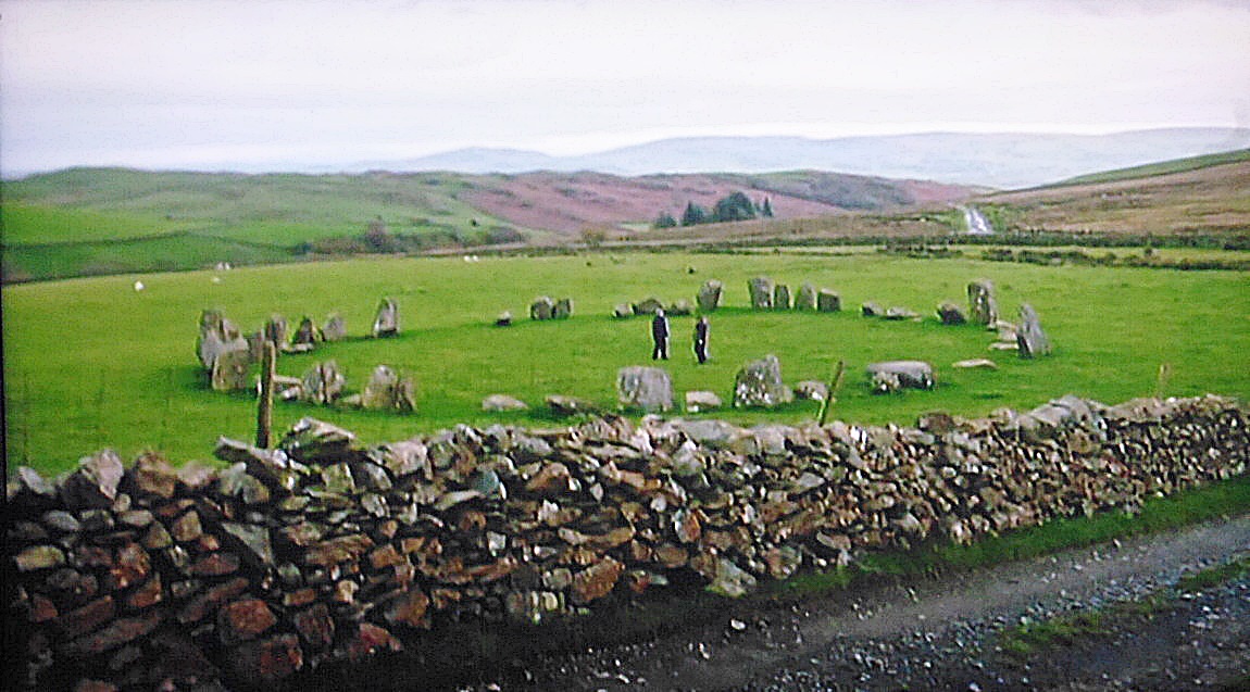
Swinside Stone Circle, 5 miles north of Millom in southern Cumbria.
NGR: SD 1716 8817. Swinside Stone Circle stands in a field beyond a drystone wall and beside a rough trackway called Corney Fell Road at Fenwick, Knott Moor, 5 miles north of Millom in Cumbria. This almost complete and well-preserved stone circle, which dates back to the early Bronze Age, is sometimes also called Swineside Stone Circle, Sunkenkirk Circle and Swines-head Circle. The ancient monument lies beside Swinside Fell to the north of Hallthwaites in southern Cumbria. It is just one of around 1,300 recorded stone circles in the British Isles and Brittany and one of three in Cumbria itself. The circle dates from the late Neolithic to early Bronze Age periods and is built from local slate with a diameter of approximately 93 feet (28 meters). There are 55 stones set close together in the circle, although there were likely to be around 60 stones there originally. A possible entrance exit is defined by two outer portal stones on the southeastern side. The tallest of the 55 stones stands at over 7 feet tall and weighs 5 tonnes.
The name Sunkenkirk seems to refer to a church or chapel that stood near the circle back in the mists of time. Conversely, the name may be due to the association with the devil who placed the stones there, or, the devil pulled down the walls of a church in that locality, or it might refer to the circle being a temple or a place of great religious significance to the ancient tribe of people who built it between 3,000-4,000 years ago.
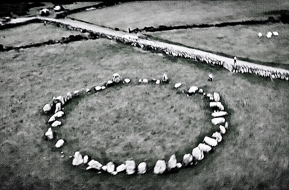
Swinside Stone Circle, 5 miles north of Millom, in southwest Cumbria.
Jacquetta Hawkes writing in 1975 tells us more about Swinside Stone Circle. She says: “One of the three best stone circles is that of Swineside, which stands folded between the fells of Black Combe and the Duddon estuary near Millom. The blocks rise from poor, rather boggy grassland, redeemed in spring by bluebells which flourish inside the circle. Small rings once standing on the coast at Annaside and at Hall Foss by Bootle have been destroyed.” Barry M. Marsden (1971) adds to the above. He says: “The circle is 90 feet across and consists of 55 stones with 2 outliers at the south-east, 9 feet apart, suggesting an entrance. Excavations have shown that the stones are bedded on a layer of small, packed pebbles.” The Travellers Guides (1965) says similar to those above but adds: “A megalithic circle on the NE flank of the fell [Black Combe]. From the summit continue along the main ridge and descend towards a cart-track beside which the circle will be seen. It consists of more than fifty stones, many of which have fallen; the tallest stone is over 7 ft high. The circle is between 2,000 and 3,000 years old.”
Maxwell Fraser (Miss) wrote in 1939 that: “Beyond Swinside the road plunges into the enchanting woodlands which border the western shore of Derwentwater to Portinscale, where in 1901 a hoard of stone tools and weapons of Neolithic man was found, which can now be seen in the Keswick Museum, two miles away.”
Sources/References & Related Websites:-
Fraser, Maxwell, Companion Into Lakeland, Methuen & Co. Ltd., London, 1939.
Hawkes, Jacquetta, A Guide To The Prehistoric And Roman Monuments In England And Wales, Cardinal, London, 1975.
Marsden, Barry M., Discovering Regional Archaeology — North Western England, Shire Publications, Tring, Herts., 1971.
The Travellers Guides, The Lake District, Darton, Longman & Todd, London, 1965.
https://en.wikipedia.org/wiki/Swinside
https://www.stonepages.com/england/swinside.html
https://historicengland.org.uk/listing/the-list/list-entry/1007226
Copyright © Ray Spencer, The Journal of Antiquities, 2024.
