The Journal Of Antiquities

Ancient Sites In Great Britain & Southern Ireland


The Nogworth and Beth Crosses, Briercliffe, Lancashire

The Nogworth Cross-base, Briercliffe, Lancs

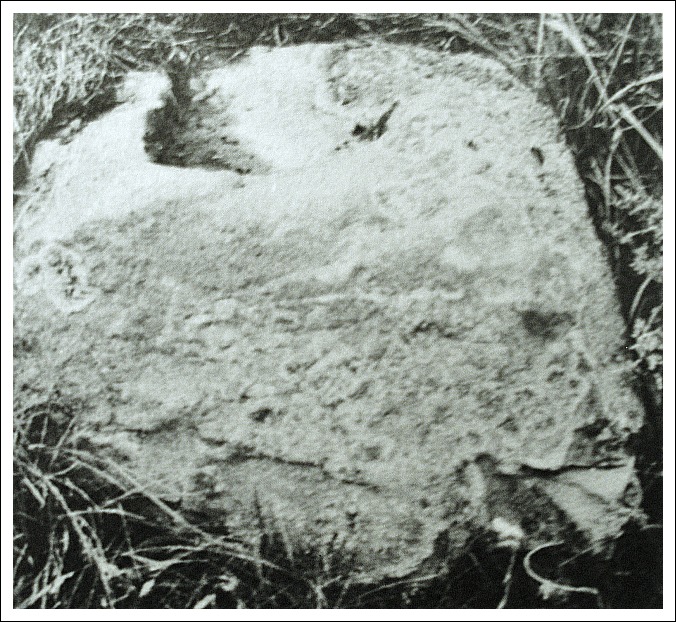
The Nogworth Cross-base, Briercliffe, Lancashire.

OS grid reference SD 8833 3408. The Nogworth Cross also called ‘The Northwood Cross’ is located to the north of Extwistle between Extwistle Hall and Monk Hall about 2 miles south-east of Briercliffe. What remains of the cross stands at the side of a country lane close to Shay Lane and Todmorden Road – having been moved here in 1909. Today only the roughly-hewn base remains, which is a slightly tapered block of sandstone about 3 feet 3 inches across and 20 inches high with a socketed recess at the top for the stump or shaft of a medieval cross – the shaft and cross-head having long since disappeared. The thinking being that this was a former market cross from the 14th-15th century? Or could it have been set-up by the monks of Whalley Abbey to mark the boundary of the land that they owned from the 13th-16th centuries? The Cistercian abbey at Whalley was founded in 1172 and dissolved in 1537. Many people walking along the country lane at Extwistle would now not even notice the lump of stone lying forgotten in the grass beside the wall, which is quite sad really.

Beth Cross or perhaps ‘The Roggerham Cross’ remains largerly forgotten and lost to the mists of time. It was a flat piece of stone with a very faint incised Latin-style cross carved onto it. It’s location is not known, but it was said to have lain in the Holden Clough area about half a mile to the south-east of the Nogworth Cross. It was thought to mark the extent of the land, or the boundary, of the land owned by the small abbey of Newbo near Sedgebrook in Lincolnshire, which was a Premonstratensian foundation founded in 1198 but abandoned soon after 1401. But why did they hold land at Roggerham so far away from their religious house in Lincolnshire. This is something of a mystery. And to confuse things even more there was a ‘Dennis Cross’ and also a ‘Widdop Cross’ (site of) in the same area. Roggerham itself is a tiny hamlet along Todmorden road, Extwistle, to the east of Lee Green reservoir and is not even mentioned on the Os maps. The name ‘Beth Cross’ is a shortened form of Elizabeth’s Cross (maybe some association with St Elizabeth?).

English: Nogworth Cross Shay Lane Base and soc...

Nogworth Cross (Photo credit: Kevin Rushton – Wikimedia Commons)

These wayside crosses were all surveyed by Mr Clifford Byrne in the late 1960s though his work was never published – he also did a survey of Holy Wells and Mineral Springs of North-East Lancashire. [Any further information on the Beth Cross or The Roggerham Cross would be very much appreciated].


Sources:-

The Briercliffe Society (Newsletter archive number 92 May 2007).

Byrne, Clifford., A Survey of the Ancient Wayside Crosses of North-East Lancashire, unpublished manuscript, 1974.

http://www.britishlistedbuildings.co.uk/en-184021-nogworth-cross-at-sd-883-340-briercliffe


Masham Churchyard Cross, Wensleydale, North Yorkshire

English: Anglo Saxon shaft at Masham church. T...

Masham Churchyard Cross (Photo credit:  Gordon Hatton for Wikipedia)

OS grid reference SE 2266 8066. In the Valley of the River Ure, Wensleydale, 8 miles to the north-west of Ripon and some 4 miles west of the A1 in north Yorkshire stands the picturesque market village of Masham on the A6108 and, close to the market square is the ancient church of St. Mary the Virgin. Just by the south porch there is a quite rare Anglo-Saxon cross-shaft Masham Churchyard Cross which originally had some of the best carvings in the Dales, but sadly these ancient carvings are now rather weather worn. St. Mary’s church also houses two pieces of a Saxon cross.

In front of the porch stands a 7 foot (2.1 metre) high rounded cross-shaft, or pillar cross, said to date back to the 8th or 9th century AD, and probably of Northumbrian craftsmanship. It stands upon a modern stepped base that, sadly, does not do the ancient cross any justice. The top is now protected by a lead cap. Despite being heavily weather-worn the richly carved shaft is quite splendid with much beautiful carving. The cross-head has long since gone. This is a four-sectioned shaft with carvings inside round-headed arcades. Just below the top damaged section Our Lord and the Apostles are depicted, while below that are what appear to be human figures awaiting baptism, or being baptised, and also the Adoration of the Magi. But the carvings are badly worn and are now difficult to make out.

It could be that the cross was set-up as a dedication to St Wilfrid, who was bishop of Ripon from 667-669, by his many followers who were converting large swathes of northern England to Christinanity at this particular time – the cross then being the central focus as a meeting place for local Christians to hear the word of God.

St. Mary’s Church, Masham, dates from the 12th-15th century (Norman and medieval). The tower dates from 1150, but an earlier Saxon foundation of the early 7th century from the reign of King Edwin of Deira and Bernicia (Northumbria) 616-633 stood near this site. King Edwin was baptised into the Christian faith in 627 and after his death in battle at Hatfield Chase he was venerated as a saint. There are still traces of Anglo-Saxon masonry in the fabric of the nave wall. Also in the church two pieces of a 9th century Anglian cross – notably part of the cross-head (looks like a small section of an arm) and a piece of the cross-shaft.

Sources:-

Carter, Robert A.,  A visitor’s guide to Yorkshire Churches, Watmoughs Limited, Idle, Bradford, West Yorks, 1976.

https://commons.wikimedia.org/wiki/Category:St_Mary_the_Virgin_church,_Masham

Click on the link for more information on King Edwin of Northumbria   http://en.wikipedia.org/wiki/Edwin_of_Northumbria


2 Comments

Ilam Churchyard Crosses, Staffordshire

Ilam Churchyard Cross, Staffordshire

Ilam Churchyard Cross, Staffordshire

OS grid reference: SK 1325 5069. The very pretty little village of Ilam in north-east Staffordshire stands beside the River Manifold, 4 miles north-west of Ashbourne and 2 miles north of the A52. It is situated just a few miles from the border with Derbyshire. Beside Ilam Hall, an early 19th century Gothic building, stands Holy Cross church, originally a Saxon foundation, and in the churchyard near the porch and at either side of a more modern churchyard cross, are two Anglo-Saxon preaching crosses; one being a typical Mercian-style cross, although both are now without their cross-heads. In the church, there is the medieval shrine and tomb of the local hermit saint, Bertelin, and close by are two holy wells associated with the saint, which were credited with miraculous healing powers.

The smaller of the two crosses is described as traditionally Mercian in style. It stands at 4 feet 3 inches high and is a cyllindrically-shaped pillar with very little of it’s round cross-head surviving, having suffered from vandalism, although a small boss can still be seen. A raised collar runs around the middle with some raised links running downwards forming a square. The rest is now well-worn and difficult to identify. When it was examined just below ground in 1890 by Rev G.F.Browne it was found to be standing in a rude-stone socket. The second cross over 5 foot high is the more normal Anglo-Saxon thin pillar-shaped cross that has been restored in two places – again due to vandalism. The cross-head has long since gone. However, this cross still displays some interesting carvings, including a scroll or circle, knotwork interlacing and at the bottom what could be the top part of a human figure is portrayed in a rounded panel. Both crosses date from between the 8th and 11th centuries AD.

A third rather battered cross shaft stands on Paradise Walk beside the River Manifold in Hinkley Woods half a mile to the south-west of the church. This one was rescued in 1840 from the foundations of a cottage close by and was said to have originally marked the site of a battle between the Saxons and Danes. It is referred to as ‘The Battle Stone’. The well-worn carvings are similar to those on the two Ilam churchyard crosses, and of a similar date.

Ilam Churchyard Crosses, Staffordshire.

Ilam Churchyard Crosses, Staffordshire.

In Holy Cross church is the medieval shrine tomb of the local Saxon saint, Bertram, Bertelin or Bettelin, an 8th century prince of Mercia who lived here as a hermit. According to the Legend, St. Bertram visited Ireland where he married an Irish princess, but soon returned to his father’s kingdom of Stafford (his father may have been King Ethelbald?) along with his pregnant wife, but on the way both his wife and newborn baby son were killed by wolves. Later, he became a Christian and studied under St. Guthlac at Crowland, Lincolnshire, but as a penance for what had happened to his family he decided to withdraw from the world and became a hermit beside a well (St. Bertram’s Well) at Ilam. The well is still there today beneath an ash tree, locally called St. Bertram’s Ash, which can be found on Bunster Hill near Townend farm to the north of the village. This healing well is located on a strong ley-line that links the prehistoric sites of Foolow and Arbor Low in Derbyshire, a distance of over 16 miles.

But there is another well associated with the saint just a little south of the church beside Paradise Walk. This is a rectangular walled construction with a holy water basin (baptismal pool) in the middle. St. Bertram supposedly died here at Ilam in the early 8th century AD and his tomb and medieval shrine were built over his resting place within Holy Cross church to which pilgrims came, and still do, in the hope of a miraculous cure. However, some historians are of the opinion, whether right or wrong, that the saint died at Stafford, of which he is now the patron saint, with his feast day on the 10th of August.

Sources:-

Sharpe, Neville T., Crosses Of The Peak District, Landmark Publishing Ltd., Ashbourne, Derbyshire, 2002.

Pickford, Doug., Staffordshire – Its Magic & Mystery, Sigma Press, Wilmslow, Cheshire, 1994.

Browne, G.F. Rev., On The Pre-Norman Sculptured Stones Of Derbyshire, [thesis], 1890.

Copyright © Ray Spencer, The Journal of Antiquities, 2013 (updated 2025).


Bewcastle Cross, Bewcastle, Cumbria

English: The 7th C Bewcastle Cross (3), near t...

Bewcastle Cross (Photo credit:  Mike Quinn. (Wikimedia Commons)

OS Grid Reference: NY 5651 7466. Located at the west side of the remote Cumbrian hamlet of Bewcastle, beside the ruined Norman castle, and in the churchyard of St Cuthbert’s stands the famous and highly sculptured Anglo-Saxon Bewcastle Cross. The village is just a few miles to the north of Hadrian’s Wall and close to the border with Northumberland. The city of Carlisle is 14 miles to the southwest beside the M6 motorway, while the village of Brampton is 9 miles to the south. Also at the western side of Bewcastle are the hexagonal-shaped earthworks of Forum Cocidii (Cocidium), a fairly large early 2nd century Roman fort. The church of St Cuthbert stands inside the fort. A Roman road (Maiden Way) runs southeast from here to the Roman wall and another fort at Birdoswald (Banna).

The cross-shaft is made from a single section of sandstone but is now without its cross-head but, even so, it stands to a  height of 4.5 metres (14 feet 6 inches) and is said to date back to the 7th or 8th century AD. All four sides of the shaft are beautifully and intricately carved in relief with human figures, animals, knotwork, interlacing, scrolls and runic inscriptions (one of which recalls a 7th century Saxon king) which were probably carved by stonemasons from the Saxon monastery of Monkwearmouth in Northumbria. They were asigned to carve the cross by St. Benedict Biscop, abbot of Wearmouth in 670 AD, and may well have come from overseas; and were possibly the same stonemasons who carved the Ruthwell Cross, Dumfrieshire, in the south of Scotland, but which was formerly a part of Northumbria?

English: The 7th C Bewcastle Cross - St. John ...

Bewcastle Cross – St. John? (Photo credit: Mike Quinn. (Wikimedia)

The cross-shaft is richly sculptured with Biblical and other religious and also non-religious decoration on all its four sides. These relief carvings are set inside panels of varying sizes; the west face is considered the best because it has three carvings of Biblical characters. At the top in a panel is St. John the Baptist with a lamb (Agnus Dei), below which a short runic inscription: GESSUS KRISTTUS ‘Jesus Christ’. The middle panel has Christ in magesty holding a scroll while treading upon two beasts. The bottom carving is possibly that of St. John the Evangelist with his trademark eagle or hawk perched on his wrist. The north face has a rather worn runic inscription at the top, below which there are vine scrolls, knotwork and interlacing, while the bottom has an inscription to Kyniburg (Cyniburga), wife of King Aldfrith of Northumbria?

It is thought the runic inscription, now incomplete, on the top of the north face should be interpreted as:- THISSIC BEACN THUN SETTON HWAETRED WAETHGAR ALWFWOLTHU EAC OSWIUG CEBID HEO SINNA SAWHULA which roughly translated is ‘This slender pillar (cross) of Hwaetred, Waethgar and Alwfwold set (it) up in memory of Alefrid, a king and son of Oswy’. ‘Pray for them, their sins and their souls’. The east face (top to bottom) has interlinking vine-scrolls in one complete panel, while the south face is carved with three more panels of interlacing, knotwork, scrolls, chequers and a cross; this face also has a very rare sundial. King Alcfrith ruled Northumbria (which included Cumbria, the northern Pennines and Scottish borders) between 685-704 AD, and was said to have been a scholarly ruler, a patron of the arts, and generous to the monastic church during the late 7th century.

Sources:-

Board, Janet & Colin., Ancient Mysteries Of Britain, Diamond Books, 1994.

https://en.wikipedia.org/wiki/Bewcastle_Cross

Kerr, Nigel & Mary., A Guide to Anglo-Saxon Sites, Paladin, London, 1982.

Maughan, John Reverend., The Bewcastle Cross Inscriptions, Manuscript in Durham University Library.

More information and photos by Mike Quinn here:  https://en.wikipedia.org/wiki/Bewcastle_Cross

Also take a look here:  http://www.bewcastle.com/bewcastle-cross/

Copyright © Ray Spencer, The Journal of Antiquities, 2012, and up-dated 2020.


Rey Cross Roman Camp, Stainmore, Cumbria

OS grid reference: NY 9004 1241. This is a difficult one to reach. You will need to park in one of the east-bound lay-bys beside the A66 Stainmore Pass dual carriageway on the summit and then find a stile allowing access to the earthworks of this 1st century AD Roman marching camp at Buzzard Hill. [A word of caution here please do be very careful as the road can be quite dangerous]. The almost rectangular-shaped earthworks are much more prominent once you get close up to the site. Most of the camp lies on the north side of the road, but a section (south-side) can be found on the opposite side of the A66, near the river Greta, although it is probably not worth crossing over the road for.

The camp was probably built sometime between 70-72 AD when the 6,000 strong IX legion under the Roman governor Quintus Petillius Cerialis came to the north of England to subdue the Brigantes and Venutius, husband of the warrior Queen, Cartamandua, then forming a rather tenuous alliance. Petilius later defeated and murdered Venutius at Stanwick c72 AD. The A66 follows the course of the Roman road between York (Eboracum) and Carlisle (Luguualium), but it seems the road was constructed slightly later than the marching camp in the early 1st century AD? eventually linking many camps, forts and fortlets along the way, including those nearby at Bowes Moor, Bowes (Lavatris), Maiden Castle and Brough (Verteris). It is, however, believed Rey Cross marching camp was only occupied for a temporary period, perhaps a few weeks, months or a year? The camp appears to have been re-occupied during the 3rd-4th centuries AD because some pottery has been excavated from that period.

The earthworks are spread over 20 acres or 296 metres from east to west and 144 metres north to south with fairly strong ramparts of stone and earth and, an external ditch. At the south side these ramparts still stand to a height of approx 6 feet in the centre and approx 20 feet wide at its base. But the northern ramparts are much more intermittent and less strong due to boggy ground conditions, indeed part of the northern section has sunk into the ground. There are traces of an external ditch at the north side measuring just 0.4 metres and, at the north-west just under 1 metre. During excavations in 1990-1 before the road was widdened into a dual carriageway, an external ditch at the eastern and western sides was found. This was some 2 metres wide and just under 1 metre deep with a berm of 1 metre in width. Near the north-east corner of the camp there is what is probably a Bronze-Age stone circle, something the Romans had clearly taken in to account.

There were at least 9 gateways (tituli) each being about 10 metres in width at the north, south, east and western sides of the camp; however, at the south-western side a couple of the south-eastern gateways have been obliterated by the A66 which bisects through this lower part of the earthworks, and recent limestone quarrying has not helped the situation. Three gateways at the north-side are still visible today. Close to the south-western side there is a small mound which sits where the quarrying occured, although this feature has, luckily, survived. This may well have been a small signal station? – there were others in an alignment sited at intervals along the Roman road, now the A66.

Rey Cross, Stainmore, Cumbria

In a lay by at the side of the A66 to the east of the Roman camp stands the stump and base of an Anglo-Saxon cross (Rey Cross), dating from c946 AD when it was set up by King Edmund of Northumbria to mark the boundaries between his own territory and Cumbria (Strathclyde). However, legend says that in c954 the Viking ruler of York, Eric Bloodaxe, fled from York into Cumbria, being murdered and buried here at that time. There is no evidence for that. The cross originally stood within the Roman camp, but in 1992 it was re-located to its present position when the A66 was widened. Sadly the wheel-head and the upper section of the shaft have long since disappeared, leaving just the worn stump socketed into a more modern lump of stone or concrete. The cross would originally have been 3 metres high. Today there are no signs of any Saxon carvings, the inclement weather conditions upon Stainmore having put paid to that.

Sources:-

Wilson, Roger J.A., – A Guide to the Roman Remains In Britain (Fourth Edition), Constable, London, 2002.

Transactions of the Cumberland and Westmorland Antiquarian and Archaeological Society (TCWASS), (2nd Series) xxxiv (1934) pages 50-61.


St Boniface Church, Papa Westray, Orkney Isles

English: St Boniface Kirk, looking towards Westray

St Boniface Kirk, Papa Westray (Photo credit: Wikipedia)

OS grid reference: HY 4882 5270. At the far north-west corner of Papa Westray overlooking the cliffs of Runnapitten, about half a mile north of the hamlet of Holland and a little to the west of Kirk house, stands the tiny medieval church of St Boniface. This was the site of a 7th or 8th century monastery and the probable site of a Pictish settlement. But the area around the church also has some Bronze-Age and Iron-Age antiquities – there was a 10-foot-high prehistoric roundhouse, or broch, just east of the church where an Iron-Age settlement existed, though nothing much remains of that now, apart from the earthworks. In the churchyard of St Boniface’s there is a Viking hog-back gravestone, which would also mean there was a Viking settlement here, and part of an early Pictish cross-slab – originally there were two stones with crosses carved onto them, excavated in the churchyard. These were removed for safety to nearby museums.

The little church (kirk) dates from the 12th century but there was probably a monastery on the site back in the 7th or 8th century AD, founded by St Boniface, bishop of Ross in Scotland; indeed the place is sometimes called Munkerhouse (monks’ house). St Boniface and his Celtic monks would have served the Pictish community here and converted this dark age tribe to Christianity at the beginning of the 7th century. Historians place the death of St Boniface at c. 630 AD, though some have placed his death in the early 8th century. He founded over one hundred churches in the north of Scotland, including the one on Papa Westray, Orkney. His feast day is given as 14th March. In 1700 the little church was enlarged, but by 1930 it had been abandoned and left to become ruinous. However, in 1993 it was fully restored both inside and out, and is now in use once again for services.

Close to the churchyard wall, amongst more modern gravestones, there is a Viking hog-back tomb stone from the 11th or 12th century? although this is now very worn and it is difficult to see any of the carving. According to legend, this marked the grave of Earl Rognavald Brusison who was the nephew of St Magnus the martyr of Kirkwall. Close by, part of a Pictish cross-slab; the main part of the stone being removed for safety to the National Museum of Scotland at Edinburgh. This slab was carved with a circular cross and also an incised cross. In 1966 a second Pictish cross-slab was excavated from the north-east corner of the churchyard. This had a Pictish-style cross and a circle with a small decorative cross inside, but for safety reasons is now housed in the Tankerness House Museum in Kirkwall.

Sources:-

Tait, Charles., The Orkney Guide Book (Edition 2.1), Charles Tait Photographic, Kelton, St.Ola, Orkney, 1999.

Armit, Ian., Celtic Scotland, B T Batsford, London, 2005.

Click on the link for a photo of the hog-back tombstone at St Boniface. http://www.google.com/imgres?num=10&hl=en&biw=1093&bih=503&tbm=isch&tbnid=hdKQOtI930kZnM:&imgrefurl=http://globetrotter-games.com/travel/Photo2002Orkney/OrkneyIndex.htm&docid=c-A3Oe3fBHqsfM&imgurl=http://globetrotter-games.com/travel/Photo2002Orkney/020912_051_Papa_Westray_-_Hogback_at_St_Boniface.jpg&w=400&h=267&ei=k6tgUOzmHuK-0QWvmYCICQ&zoom=1&iact=hc&vpx=637&vpy=166&dur=6330&hovh=183&hovw=275&tx=169&ty=129&sig=116874016552324944431&page=4&tbnh=138&tbnw=173&start=40&ndsp=15&ved=1t:429,r:8,s:40,i:236

Copyright © Ray Spencer, The Journal of Antiquities, 2012.


St Edward’s Church Crosses, Leek, Staffordshire

NGR: SJ 9835 5662. St Edward’s parish church is located on Church Street the A523 road just to the north-west of the market-place in Leek town centre. In the churchyard stand two ancient preaching crosses from the 7th-11th centuries, one of which is called a Mercian cross, the other is of Anglo-Norse origins, while inside the church there are a number of fragmentary pieces of Anglo-Saxon stone carvings and, also the famous ‘Calvary Stone’ also known as the ‘Tree of Life Stone’, which dates from about the same period – the 10th century AD.

The tallest of the two churchyard crosses stands at the side of the church near the chancel door. It is 10-11 feet high and stands on a more recent stepped base, the original base being a large unhewn lump of stone with a Latin inscription. This cross has a round-shaped shaft that gradually tapers away, above a prominent collar, towards the top where the wheelhead is broken and missing. Sadly, the cross is now quite worn although some carvings can still be made out near the top of the shaft, especially on the collar, which is an interweaving pattern fashioned in the form of a flowing serpentine with its design work from the Scandinavian school of carving and, above that a single long loop of thick ropework with interlacing inside that on all four faces. Below the decorated collar are three rather crude heads that are different on the north, south and east faces, but each one generally having long, flowing and curling hairstyles. There is an old saying that: “When the churchyard cross shall disappear Leek town will not last another year”. This may happen sooner rather than later as [this cross] is said to be sinking further into the ground every year.

Anglo-Norse Cross at St Edward’s Church, Leek, Staffordshire

The second churchyard cross standing close to the main entrance is 8 feet high on its modern square-shaped base. It is a restored rectangular cross-shaft of what is referred to as “the Mercian type”. The carvings on the front face are a panel of interlacing and interlocking strands. However, on the other faces what is left of any decoration is badly worn away. This cross was found broken in three sections and has had to be restored to as good as can possibly be.

Inside the 13th-century church at the northwest corner of the nave is a collection of Anglo-Saxon stones, the best of which is the so-called ‘Calvary Stone’ or ‘The Staff of Life Stone’. This 10th-century lump of stone shows Christ carrying his cross, or perhaps it is a figure carrying a long sword or spear with which to kill the mythical serpent, this one looking like a long worm! The head of another serpent can be seen at the bottom of the stone. The carving could, in fact, be a depiction of ‘The Tree of Life’. On the edges of this stone there is some typical Saxon knotwork. There is also a large lump of nicely decorated cross-shaft, and also two other fragments that may have come from Saxon wheel-head crosses.

Sources:-

Pickford, Doug., Staffordshire Its Magic & Mystery, Sigma Press, Wilmslow, Cheshire, 1994.

Biddulph, Elizabeth Ann., Leek’s Forgotten Centuries – It’s Ancient History Unearthed, Spellcraft Books, Leek, Staffs, 1999.

Copyright © Ray Spencer, The Journal of Antiquities 2012 (updated 2024).


Fat Betty Cross, Danby High Moor, North Yorkshire

NZ6822 0199. The medieval cross known as Fat Betty or White Cross stands beside a trackway on Danby High Moor at the head of the Rosedale Valley to the east of Rosedale Head. It has acted as a wayside cross/marker stone for hundreds of years for travellers going between Rosedale and Westerdale; the nearest village being Botton, a few miles to the north. But it is easy to become lost on these windswept moors and so these crosses and waymarkers would have been a great help to pilgrims and others traversing the North York Moors from medieval times and, indeed, until more recent times, no doubt.

English: White Cross, Rosedale. White Cross is...

Fat Betty or White Cross (Photo credit: Wikipedia)

Fat Betty Cross is about 4 foot high, square and squat in shape, with a funny little round-shaped head or wheel-head on top that has four small indentations that almost look like a human face. The whole thing is really a solid block of stone that is painted white from about halfway up, hence the name “White Cross”. It may have originally had a cross-shaft attached. There are some tiny thin carved crosses on either side, and also some more recent Victorian lettering or graffiti within a carved square panel on the main face. The cross is thought to date from the 12th century and, may well have been placed here as a wayside cross for the nuns at nearby Rosedale Abbey; the religious ladies themselves apparently wore a white habit, so could that be where the name is derived from?

But myths and legends seem to be numerous with regard to the history of the old cross. One legend tells us that two nuns and their attendant from Rosedale abbey found themselves lost in thick fog on the moor; they were eventually found dead and the cross was set up to commemorate them. Another legend says it was named after a nun called Margery or Margaret and originally it was called “Margery Cross”. And yet a third says that a local farmer’s wife died here. Her husband found her dead here and set up the cross in her memory – the farmer’s wife was apparently called Margaret or Betty. There could be some truth in these stories and old legends or maybe not; the real truth is now lost in the mists of time. Two more wayside crosses, Ralph Cross and Old Ralph Cross, stand just a short distance to the west.


The Burnley Cross, Burnley, Lancashire

OS grid reference: SD 8424 3307. Just along from St Peter’s parish church at the north side of the old Burnley grammar school at the junction of two roads, Bank Parade and Church Street, there is a small secluded hidden garden surrounded by a wall and railings. Here stands the so-called Burnley Cross or Paulinus Cross and, also there is a 19th-century cross-base and the old stone well-head of ‘The Shorey Well’, which used to stand beside the River Brun on the opposite side of the road.

The Burnley Cross, Lancashire

The blackened gritstone cross is about 3 metres in height, its thin shaft tapering away towards the top where there is a very mutilated wheel-head. In the centre a small round boss can be seen, but sadly the arms of the cross-head are almost gone. There are some faint traces of carving on the head and also on the shaft, but these are very faint now. The base of the cross is a rectangular, chamfered stone into which the monument is well-socketed. It is thought the cross was originally erected in 1295 for the price of “9 shillings and one penny” opposite St Peter’s parish church, in the area known as ‘top o’th’ town, but in 1617 a new market cross was set up in Godley Lane, close by Ormerod Road, while the old one was placed in its present position in 1880. Its appearance is said to be similar in design to the Anglian crosses in Whalley churchyard, so this could be why it has been referred to as one of the Paulinus crosses, which would date it, perhaps, to the 11th century. And this, then, is where the confusion arises between that and the old market cross. The octagonal base of the old market cross stands in the grammar school garden. This has one step and a three-course plinth along with a large round, moulded pedestal, rather like a very, very large flower pot! But, clearly, the original cross shaft would not have been the right shape for this. So, is this what was referred to as the Paulinus Cross or the Market Cross?

The old stone well-head is all that remains of ‘The Shorey Well’. This was originally located on the bank of the River Brun opposite the old grammar school, and was the main source of clean drinking water for the northern side of Burnley. It could be reached along Shorey Bank, or by crossing over some stepping stones placed in the bed of the river by way of Dawson Square. But, when water pipes were brought in to use in the late 19th century there was no need for the old well; its stone surround was taken away and placed here in the little garden beside the grammar school.

The Shorey Well (remains of), Burnley.

Copyright © Ray Spencer, The Journal of Antiquities, 2012.


Tocca’s Stone, Tockholes, Lancashire

OS grid reference: SD 6584 2302. A couple of miles northwest of Darwen is the village of Tockholes. Winter Hill and it’s famous transmitter is a few more miles east of here. Go down Chapels Lane to the church of St Stephen, and, in the churchyard can be found a curious-shaped stone on a large base. This is Tocca’s Stone or ‘The Toches Stone’. The monument is not more than 4 feet high now because the top section, which could have been a cross-head, was lost to the local area. It is said to have been erected in the late 7th century AD as a preaching cross by Tocca, a Saxon chieftain – Tockholes ‘Tocca’s hollow’ takes it’s name from him. Most probably the area was ruled by some post-Roman, pagan tribe who were Christianized by wandering missionaries like St Paulinus and St Wilfred. The church of St Stephen is a modern building that replaced an earlier Victorian church. Almost certainly there was a medieval church on this site, perhaps even a much earlier Saxon building. The churchyard has a rare outdoor pulpit, dating from the early 1900s, and some old stone arches from an earlier church.

The Toches Stone, Lancashire

The stone, now alas minus its cross-head stands forgotten in many senses, but long ago it was used by local people because of it’s magical healing powers. People came here to touch the round-shaped stone at the side of the old cross shaft. They believed that if they did this some sort of cure, be it magical or divine, would be bestowed upon them. This is probably why the rounded stone is now so smooth. On the large square stone below the cross stump there is a Victorian inscription that states that the cross was set-up on the parish boundary in AD 684 along with some other details of the history. Two local gentleman apparently donated the oblong shaped-stone and re-erected the cross, but they were said to have quarrelled about the cost of the stone and where it should stand, etc.

About 3 miles south of Tockholes is a 17th century wellhouse in the grounds of Hollinshead Hall. The well, however, is much older in date. On the carved arch inside the building there is an old inscription and a carved lion’s head over a large basin. The water that once issued from the lion’s mouth was said to have had healing properties. However, today the wellhouse is abandoned and rather forgotten. It is a long time since Catholic pilgrims visited this place of sanctity; one can only peer through the windows into the dark, crumbling building.

Tocca’s Stone, Tockholes, Lancashire

Copyright © Ray Spencer, The Journal of Antiquities, 2012 (updated 2023).


The Sproxton Cross, Leicestershire

NGR: SK 8566 2490. The cross stands in St Bartholomew’s churchyard on Saltby Road at the far north side of Sproxton village. The A607 road runs along the south side of the village. Grantham is 5 miles to the north. The 12th-century Norman parish church can be found on a hill, just to the north of Manor Farm.

In the churchyard, near the south porch, stands a limestone cross dating from the 10th or 11th century that is referred to as being Anglo-Norse in origin. It stands at 7 foot 9 inches on a 19th-century base-stone that is over 2 feet square. Sometimes described as a “weeping cross” because of the way it leans! The monument is said to be the only complete cross in Leicestershire. Its wheelhead is rather odd-shaped and small in size but very nice all the same; the rectangular shaft has what is called a “raised collar” halfway up.

Of the three faces, the east side is heavily worn, due to it being used as a footbridge over a stream near Saltby; the west face has two creatures, one of which is the eagle of St John the Evangelist. Lower down a standing beast with raised feet that may be a wolf with a broad, curving tail that ends with interlacing. The north face of the cross has interlocking circles. On the side of the cross winding stems forming circles, while the wheel-head also has stems and foliage within the curves.

The Sproxton Cross (After Nichols).

The church of Saint Bartholomew is a Norman foundation of the 12th century and does not appear to have any earlier, Saxon work. Built into the south-west wall there is an interesting stone with zig-zag moulding. This is thought to date from the 11th-12th century.


Sources and References:-

Nichols, John., History and Antiquities of The County of Leicestershire, 1794.

Routh, T.E., Transactions of The Leicestershire Archaeological Society, Vol XX, 1937.

Copyright © Ray Spencer, The Journal of Antiquities, 2012 (updated 2025).


Lonan Church Crosses, Isle Of Man.

SC4273 7937. Lonan old church (Kirk Lonan or Keeil-ny-Traie) is located just 1 mile south of the A2 east-coast road at Ballakilley, 1 mile south of Baldrine and 1 mile east of Onchan. Douglas is 4 miles to the south. The church is partially ruined now but it is still a very interesting site with it’s ancient churchyard and nine Celtic-style crosses and slabs.

The little church, dedicated to St Adamnan or Eunan, dates from the 12th-14th century but there was an earlier 7th century building on this site that stood on a pre-Christian, pagan site; it’s eastern wall is probably the earliest part of the church. St Adamnan, an irish monk, was abbot of Iona in western Scotland between 679-704 AD, though St Patrick’s nephew St Lonan was the first to settle here back in the late 5th century AD. He was apparently third bishop of Mann after St Maughold. St Lonan’s holy well (Chibbyr Onan) can be found just to the south of the church. Thanks to the Rev John Quine, a local antiquarian, the church was saved from complete destruction in 1895.

The most spectacular of the nine crosses (no 73) is in it’s original position at the south side of the kirk-yard. It stands at 8 feet high and has a large equal-limbed Celtic wheel-head cross that is almost completely covered in interlacing, knot-work and plait-work designs. This dates from the 5th century AD. All the other cross-slabs stand against the north wall in the roofed area at the east side of the church. The other eight cross-slabs and fragments, numbered 23, 27, 71, 75, 76, 77, 160 and 177, are heavily worn and only faint carvings can be seen; one has been repaired and shows part of a small wheel-cross, and there are two fragments of ‘The Glenroy Cross’. These show Celtic and Norse workmanship and are more recent in date, probably 8th to 10th century AD. You can see the casts of these cross-slabs at the Manx museum in Douglas.


1 Comment

Kemple End Cross, Bashall Eaves, Lancashire

NGR: SD 6865 4045. The Kemple End Cross, also known as the Paulinus Cross, stands in the corner of a field beside a wooded area close to Birdy Brow Lane, just up from the Hodder bridge at Bashall Eaves, on the side of Longridge Fell. The town of Clitheroe is 3 miles to the west. A footpath at the northern side of the wooded area heads southeast at Fell Side farm. At first glance the cross looks like a pile of stones, but it is, in fact, a pre-Conquest cross dating back to the 7th century AD.

It is an odd-shaped cross with a crude and stubby cross-head on a short shaft that is set into a large, natural socketed base-stone that is not the original, that having vanished long ago, to where no one knows. All in all the cross and base are 5 feet high. The cross has weathered over the centuries into what it looks like today. Legend records that St Paulinus, bishop of York, preached here in the 7th century AD during his long mission in the north of England between 619-633 AD, when he apparently converted thousands to the Christian faith from Cumbria right across  Lancashire, Yorkshire and to Lincolnshire. But nowadays sheep and cattle use it as a rubbing post! He is famous for baptising King Edwin of Northumbria into the Christian faith at York in 627 AD. St Paulinus died at Rochester, Kent, in 644 AD.

A short distance to the east along a path that leads to a gate there is a standing stone that is pointed at the top and has a large hole near the middle. Could this have been a marker stone for pilgrims visiting the ancient cross, or could it have been used as a gatepost? The stone seems to be much more recent in date.

Kemple End Cross, Lancashire

Copyright © Ray Spencer, The Journal of Antiquities, 2012 (updated 2025).


The Giant’s Grave, Penrith, Cumbria

OS grid reference: NY 5165 3016. A short walk in an easterly direction from market Square and king street (A6) in the centre of Penrith is the ancient church of St Andrew, a Saxon foundation. At the north side of the church stands a slight mound on top of which are two pillar-crosses and four hogback gravestones – collectively known as the Giants Grave. These stones are said to have been placed over the burial site of Owain Caesarius, a legendary and heroic king of Cumbria during the early 10th century; and who was said to have been a giant of a man. Also in the churchyard is the Giant’s Thumb, a damaged Anglo-Norse wheel-headed cross dating from 920 AD.

The Giant’s Grave, Penrith.

The two tall and slender pillar-crosses standing 15 feet apart are now heavily worn and it is difficult to make out the carvings on them, but they have been dated to around 1000 AD and are Anglo-Norse in origin. Both crosses have sustained some damage – the taller cross with a badly damaged head is between 11 and 12 feet high, while the smaller cross, also without its head, is between 10 and 11 feet high. Set between them, spaced 2 feet apart, and embedded into two long slabs are four hogback gravestones with curved upper edges and some rather nice carvings, including spiralling and circles with crosses or interlacing inside them. These graves represent Viking houses with carved sections depicting the life of the person(s) buried beneath them, often with intricate symbols and patterns; the stones here may represent four wild boars killed by King Owain in Inglewood Forest.

Hogback Gravestone, Penrith.

Close by stands the Giant’s Thumb which also commemorates Owain Caesarius who was a legendary, perhaps mythical, king of Cumbria from 920-937 AD. This 6-foot-high monument is another pre-Conquest cross with part of its wheel-head now missing. It stands upon a 19th-century Victorian base with an inscription. According to local legend, the cross was set up at the time of Owen’s accession to the throne of Cumbria. However, some historians have argued that Owain or Ewan was, actually, Owain ap Urien the son of King Urien of Rheged in the 6th century AD, who was probably of Welsh/Irish descent. Rheged was a part of the old north country, known to the bards as Hen Ogledd, which covered a large part of northern England and southern Scotland, in particular Rheged was centred on Cumberland and Westmorland, its people speaking the old Brythonic language. King Urien of Rheged ruled from 550-590 AD.

Copyright © Ray Spencer, The Journal of Antiquities, 2012.


St Kennara’s Cross, Kirkinner, Galloway, Scotland.

NGR: NX 4241 5119. Just off the main street (A746 Whithorn) road in Kirkinner, 3 miles south of Wigtown is the parish church of St Kennera (Cinnera). The 19th-century church stands on the site of a 13th-14th century foundation and perhaps an even earlier monastic cell where lived the 4th-century hermitess, St Kennera. Inside the church stands a 4-foot high cross-slab dating from the 10th century AD. Carved on the stone there is a Celtic style disc-headed cross. The stone slab had apparently stood at the western side of the church for some time before being brought into the church for safety.

In the 4th century St Kennara left Scotland to become a missionary in the Rhineland. She was educated along with St Ursula and St Regulus (Rule) – later becoming a follower of St Ursula. According to the well-told legend, St Ursula was murdered with 11,000 holy handmaidens at Cologne ( c 383 AD) by the Huns, and Kennara was one of these martyred maidens. The legend goes on to say that the saint was strangled with a towel or napkin and her body buried in a stable that belonged to the pagan king of the Huns – his horse then refused to enter the stable while her holy body lay there. St Kennara’s feast day is usually held on the 21st or 29th of October.

Copyright © Ray Spencer, The Journal of Antiquities 2012 (updated 2024).