
Fingal’s Cave on Isle of Staffa, Inner Hebrides.
NGR: NM 3245 3503. In the cliffs at the south side of Staffa, Inner Hebrides, Scotland, is the huge sea cave known as ‘Fingal’s Cave’, taking its name from the mythical giant, Fionn mac Cumhail or Finn McCool, but its original name was An Uamh Bhinn – the musical cave. The cave is formed from hexagonal volcanic basalt columns or pillars that are the same as those at the ‘Giant’s Causeway’ in Northern Ireland. In Irish mythology Finn McCool, who was often portrayed as a hunter-warrior, was able to walk or take long strides across his bridge or causeway (he had built it apparently) on the Antrim Coast, to his cave on the Island of Staffa in the Hebrides; it was here that Finn McCool fought a Scottish giant! Staffa, off the Argyll coast, is an uninhabited Hebridean island. The sea cave looks out across the often wild Atlantic Ocean, which is very often rough and stormy, and so it’s not easy to get close up to the cave unless the sea is calm – at which time motorboats from Oban carrying sightseers can get closer to it, and, even allow a few hardy souls to disembark and walk into the cave mouth. The entrance to the cave is 66 feet high, while inside it is said to be around 227 feet long. Fingal’s Cave is in the guardianship of The National Trust for Scotland. There are three other sea caves on the Island of Staffa.
It was the Scottish explorer Sir Joseph Banks (1743-1820) who discovered the cave and named it after the mythical Irish hero, Finn McCool, and not James Macpherson, while Pennant’s tour of 1774 provided the earliest description. In 1830 German composer Felix Mendelssohn (1809-47) composed his famous piece of music: Fingal’s Cave (The Hebrides Overture).
Wonders of the World (1930) tells us that: “The Island of Staffa, lying off the coast of Argyll, is famous for Fingal’s Cave, a marvellous geological formation akin and certainly connected with the Giant’s Causeway of Ireland. Each side of the entrance is flanked by columns or pillars supporting an arch. It is these pillars, reminding us of the basaltic rock formations of the Giant’s Causeway, that have given the island its name, for Staffa is the Scandinavian equivalent for “pillar.” They are sixty-six feet high and forty-two feet apart, and are as perfectly shaped as though the hand of man and not the action of the water had chiselled them.
“The length of the cave proper is two hundred and twenty-seven feet, and its floor is formed by the water which enters from the sea and throws up “flashing and many-coloured lights against pendent columns,” against the white calcareous stalagmites which form the roof, and against the pillared walls of this weird cave. The lapping of the sea against the base of the cliffs reverberates and re-echoes with a musical intonation, on days of calm, and it swells to a thunderous roar during a storm or tempest which is the more usual condition on this rocky island set in the turbulent waters that wash the rugged west coast of Scotland.”
Romantic Britain (1939) says, regarding some of the ancient cromlechs in Ireland: “In Romantic tradition they are known as “Giant’s Graves,” and sometimes “Beds of Diarmuid and Gráinne,” those legendary lovers who fled from Gráinne’s betrothed husband, Fionn MacCool, and were pursued all over Ireland by a revengeful Fionn and his army of Fenians.

Fingal’s Cave and Stormy Seas as seen from above.
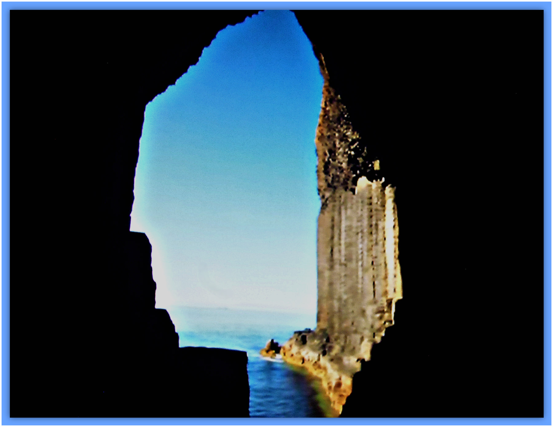
Fingal’s Cave, Isle of Staffa (the inside, looking out to the sea).
“The Fianna or Irish Militia headed by Fionn reached the peak point of its glory in the third century A.D. during the reign of Cormac MacArt. Many and marvellous are the stories associated with its fame. The Giant’s Causeway at Antrim is said to have been flung across the sea to Scotland by Fionn, to hasten his hostile encounter with a fearsome Scottish rival. Cloughmore (Big Stone) at Rostrevor, was hurled, it is said, by the Scottish giant at Fionn’s head and just missed it! Fionn retaliated with the Isle of Man which he pulled out of the space now occupied by Lough Neagh. The dolman at Howth, near Dublin, is pointed out as the burial place of Aideen, wife of Fionn’s son Oisin, while Fionn’s two moated palaces were situated at the vantage points of Moyvalley, in Offaly, and the Hill of Allen, in Kildare. Scarce a spot in Ireland does not treasure some legend of the renowned Irish Giant.”
John & Caitlin Matthews, writing in 1988, tell us more about Fingal. They say that: “Fingal Fionn mac Cumhal is sometimes called this in Gaelic Scotland. The name also derived some popularity from the bogus, ‘Ossian’, written by MacPherson in the late eighteenth century; drawing on oral stories about Fianna. James MacPherson fabricated a set of romantic Celtic poems which impressed and fired Europe to a reconsideration of Celtic culture, though his work was soon discovered to be a fake.”
Joyce Miller writing in 2000 tells us more about Staffa, saying: “The romantic, uninhabited island is well known for the extraordinary basaltic column formations. The best known of these is Fingal’s Cave, named after the old hero Fin MacCool. The cave can be viewed from a boat, or from the island if weather conditions permit. Boats leave from Fionnphort on Mull or Iona.”
Sources / References & Related Websites:-
Matthews, John & Caitlin, The Aquarians Guide To British And Irish Mythology, The Aquarian Press (Thorsons), Wellingborough, Northamptonshire, 1988.
Miller, Joyce, Myth and Magic — Scotland’s Ancient Beliefs & Sacred Places, Goblinshead, Musselburgh, Scotland, 2000.
Romantic Britain — The National Heritage of Beauty History And Legend, (Ed: Tom Stephenson), Odhams Press Limited, London, 1939.
The AA, Illustrated Road Book Of Scotland, The Automobile Association, London, 1963.
Wonders Of The World, (Forward by Sir Philip Gibbs, K.B.E.), Hutchinson & Co. (Publishers) For Odhams Press Ltd., 1930.
https://en.wikipedia.org/wiki/Fingal%27s_Cave
https://en.wikipedia.org/wiki/Staffa
More Info here: https://visitmullandiona.co.uk/listings/fingals-cave/
https://ctdots.eu/places/scotland/fingals-cave-staffa-island-oban/
https://www.atlasobscura.com/places/fingal-s-cave
Copyright © Ray Spencer, The Journal of Antiquities, 2022.


