The Journal Of Antiquities

Ancient Sites In Great Britain & Southern Ireland


Trippet Stones and Stripple Stones, near Blisland, Cornwall.

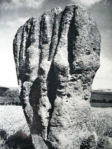
The Trippet Stone Circle, Bodmin Moor, Cornwall.

NGR: SX 1310 7500  &  SX 1440 7520 respectively. On Manor Common, near Blisland, Corn-wall, are the Trippet or Tripping Stones, which are actually a stone circle of standing and fallen stones. Approximately 1 mile to the northeast, another stone circle, the Stripple Stones, is situated within a henge monument on the south slope of Hawk’s Tor, located on the edge of Bodmin Moor in Cornwall. Both stone circles can be found in direct sight of each other, which would seem not coincidental when the second circle was built, probably in 1700 BC. Both ancient monuments are located some 6 miles northeast of Bodmin, near the A30 road. The Trippet Stone Circle (also known as the Dancing Stones) has a diameter of around 32 metres (105 feet) and is thought to date back to the Bronze Age; and at its centre, a more recent standing stone, whereas the Stripple Stone Circle, which has a recumbent stone at its centre and a few other outer stones, is just over 44 metres (145 feet) in diameter and dates back to the Neolithic period.

James Dyer, writing in 1973, says of Trippet Stones: “This is a small but impressive circle of eight standing, and four fallen, stones, 33 m in diameter. Most of the stones are roughly rectangular blocks, about 1.5 m high. In the centre is a modern boundary stone.”

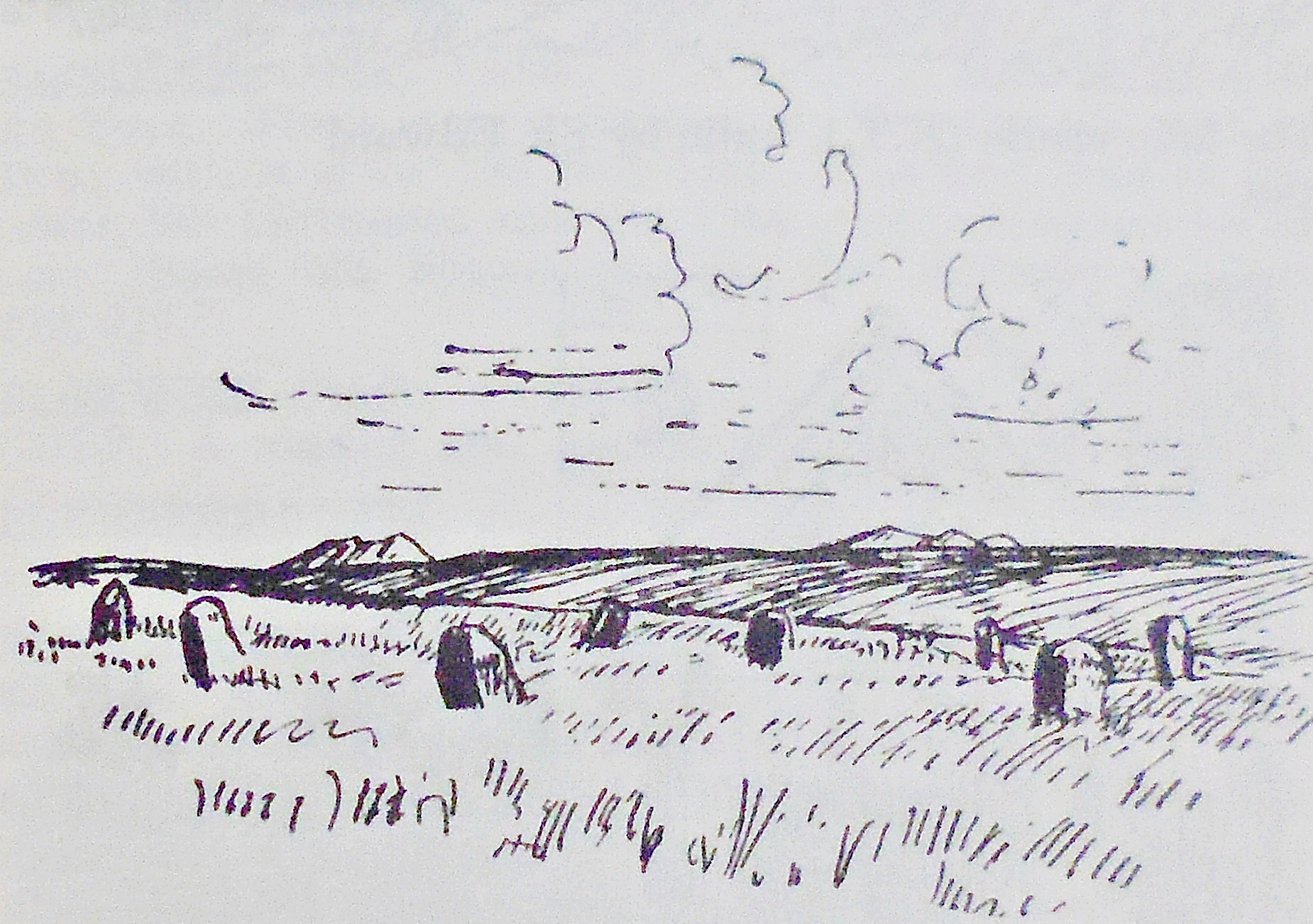
Plan of Stripple Stone Circle and Henge on Bodmin Moor, Cornwall, from the Wikipedia website.

James Dyer, writing in 1973, says of Stripple Stones that: “On the slope of Hawks Tor is an em-banked enclosure with internal ditch 68.3 m in diameter. Inside it is an irregular circle of fifteen (formerly twenty-eight) granite blocks, only four of which are still standing. Almost in the centre of the stone circle, which is 44.5 m in diameter, is a single recumbent stone, and three others lie outside the circle but within the earthwork. Excavations by H. St. George Gray in 1905 showed that the surrounding ditch was very irregular, but averaged 2.7 m wide and 1.2 m deep. It was broken by an entrance facing south-west towards the Trippet Stones. The stones themselves were in shallow holes, none more than 0.8 m deep. The site is clearly a henge monument by the position of its internal ditch. The presence of the stones suggests a continuity between the Neolithic henge and Bronze Age stone circle. Modern excavation might reveal that the earthwork is older than the stone setting.” 

John Michell, writing in 2003, says of both the Stripple Stone Circle and the Trippet Stone Circle and the surrounding area: “The Stripple Stones and the Trippet Stones. These two circles stand within a mile of each other on Bodmin Moor below Rough Tor. They were evidently connected, for they are inter-visible and the entrance to the first circle is orientated towards the second. The Stripple Stones are unique in Cornwall, being the only henge circle. The surrounding earthwork has its ditch inside, proving its ritual rather than defensive function. Most of its stones, including the central are now fallen. In the same district are the Leaze Circle to the north-west and, on the east side of the moor, the small and attractive Nine Stones Circle at Altarnen. The Fernacre circle is one of the largest on Bodmin Moor, up to 150 ft across. Its siting is spectacular, with views to Rough Tor, Brown Willy and other landmarks. Originally, it consisted of about 90 stones, most of which are now fallen or missing.”

Mr Michell goes on to say that: “Several circles, together with the only Cornish stone row, are called Nine Maidens, and are supposed to have nineteen stones, representing a lunar cycle. The other common legend is that the stones are petrified dancers or musicians. That was their punishment for dancing and playing on the Sabbath. Near St Buryan in the far west, the Merry Maidens circle, which the old Cornish named the Dancing Stones, was said to represent unauthorised merry-makers who were turned to stone. The same legend is in the name of the Trippet (tripping or dancing) stones on Bodmin Moor.”

Sources & References & Related Websites:-

Dyer, James,  An Archaeological Guide — Southern England,  Faber, London, 1977.

Michell, John, Prehistoric Sites in Cornwall, Wessex Books, Salisbury, Wiltshire, 2003.

The AA, The Illustrated Road Book of England & Wales, The Automobile Association, London, 1961.

http://www.stone-circles.org.uk/stone/trippet.htm

Wikipedia website: https://en.wikipedia.org/wiki/Stripple_stones https://commons.wikimedia.org/wiki/File:The_Victoria_history_of_the_county_of_Cornwall_(1906)_(14590965339).jpg

https://www.historic-uk.com/HistoryMagazine/DestinationsUK/Bodmin-Moor-Historic-Monuments/

© Copyright, Ray Spencer, 2025.


Duddo Five Stones, Northumbria

Duddo Stone Circle This beautiful stone circle...

Duddo Stone Circle  (Photo credit: Andrew Curtis – Wikipedia)

OS grid reference NT 9305 4370. Three-quarters of a mile to the north of the village of Duddo in Northumbria stands the Bronze-Age monument known as Duddo Five Stones, which are actually the remains of a small stone circle. The five stone monoliths stand clustered together at the western side of Mattilees Hill beside a footpath in a field halfway between Grindonrigg and Felkington. Coldstream on the A698 is 6 miles to the south-west, while the nearest main road to the stone circle is the B6354. Scotland is 4 miles to the north!

The five stones stand upon a low, grassy hill (tumulus) and cover an area of 10 metres or nearly 33 feet. It’s likely the circle of stones marks the site of a prehistoric burial, dating from the Bronze-Age upto 4,000 years ago; the stones being erected over this as a sign that it was, and still is, a sacred place where a chieftain or some other notable person(s) lie buried, perhaps several members of an ancient tribe? The tallest of the stones is 2.3 metres high or 7 foot 6 inches; the other stones are less high and vary in size from 1.5 metres to 2.1 metres (5 foot to 6 feet 10 inches) high. Originally, there were seven standing stones, but the other two were lost in c1850. During excavations in the 1890s and early 1900s two holes were uncovered indicating where the other two monoliths had stood and some bones and charcoal were found. One of the stones had later toppled over which had led to Ordnance Survey recording on their maps that the site was called Duddo Four Stones. Luckily, this stone was re-erected in 1903 and one or two of the other stones may not be (in situ) in their original places. Aubrey Burl, the well-respected English archaeologist, has visited the site on a number of occasions since the 1970s.

Duddo Stone, Northumbria.

Duddo Stone (picture credit Garry Hogg)

Over the centuries The Duddo Stones have aquired many strange names owing perhaps to the deep grooves that can be seen in all the stones – caused by 4,000 years of erosion due to rain and wind that often sweeps relentlessly across the hills and moors and, because the stones are made of sandstone rain running down the sides has made strange grooves or gulleys. The largest stone has been likened to “a clenched fist rising menacingly out of the rough turf,” according to Garry Hogg in his book Odd Aspects of England. One legend says that seven people working here on the Sabbath day were turned to stone as a warning to other locals. Other names include: ‘The Singing Stones’, ‘The Women’ and ‘The Seven Turnip Pickers’! The largest stone has possible cup-marks and there are said to be cup-markings on one or two of the other stones. Duddo Five Stones is said to be aligned with the Winter solstice. The circle is in the ownership of English Heritage.

Sources:-

Hogg, Garry., Odd Aspects of England, David & Charles, Newton Abbot, Devon, 1968.

Bord, Janet & Colin., Ancient Mysteries of Britain, p 208, Diamond Books (Harper Collins Publishers Ltd), 1991.

https://en.wikipedia.org/wiki/Duddo_Five_Stones

http://heritageaction.wordpress.com/2012/10/07/setting-of-duddo-stone-circle-saved-again-for-a-while/

Copyright © Ray Spencer, The Journal of Antiquities, 2013.


Yockenthwaite Stone Circle, North Yorkshire

OS grid reference: SD 8997 7938. The Yockenthwaite stone circle stands by a footpath in a valley on the north bank of the river Wharfe, close to the hamlet of Yockenthwaite in Langstrothdale, and just west of the B6160 road. Buckden village is 4 miles to the south-east, while another hamlet, Deepdale, lies just a little to the north of the winding country road to Hawes. The circle is near to Yockenthwaite farm. Although many historians call it a stone circle it is actually a Bronze-Age ring cairn with a circle of small stones (kerbstones) that are still quite clearly defined.

The stone circle consists of 20 small stones set almost edge to edge that are roughly 3 feet high, covering a diameter of 25 feet. These stones are, infact, the kerbstones of what remains of a burial cairn or ring cairn where a prominent tribal chieftain was buried. Just outside the circle at the north-west side are a few other stones that make up an outer, concentric ring, and a few portal stones that formed the entrance. In the middle of the circle a small mound can just be made out, which would have been the site of a burial. Originally, there would have been a mound of earth covering the stones but this has long since gone. Just to the north of the circle are what could be the remains of another burial cairn.

English: Yockenthwaite Stone Circle A small (2...

Yockenthwaite Stone Circle by John Illingworth (Photo credit: Geograph)

The name Yockenthwaite is said to be of Scandinavian origins. Thwaite meaning ‘a clearing’, while Yocken could be a derivation of ‘Eogan’ of probable Irish origins – hence we get the place-name ‘Eogan’s clearing’. Thwaite is quite a common place-name is the Yorkshire Dales and also in north-eastern England giving us some idea where Norse invaders came to settle in the 9th-11th centuries.


Sources:-

Raistrck, Arthur., The Pennine Dales, Arrow Books, London, 1972.

Geograph/Wikipedia photo by John Illingworth. http://www.geograph.org.uk/photo/549996

https://en.wikipedia.org/wiki/Yockenthwaite


Castlerigg Stone Circle, Keswick, Cumbria

NGR NY 2913 2362. Castlerigg stone circle or the Druid’s Circle stands on a flat hilltop close to Castle lane, just south of Goosewell farm, 1 mile north of the A591 at Castlerigg village and 2 miles east of Keswick. Although referred to as a circle, it is actually oval in shape and probably dates from the late Neolithic to the early Bronze Age periods 3,370-2,670 years BC. There are some excellent panoramic views to be had from the circle of the distant mountains of the lake district.

All of the stones and boulders ranging from small and large ones that make up the circle are glacial erratics made of metamorphic slate; these would have been moved into a suitable circular position. There are between 38-40 standing stones (also called carles) the correct number being difficult to count, 33 of the stones are standing while the rest are recumbent. Inside the circle 10 stones form a rectangular cove or sanctuary, the eastern section of which connects with the outer circle (perimeter), and is regarded as quite an unusual feature. At its most widest point the circle measures 32 metres (107 feet) in diameter and at its narrowest point it is 29 metres or roughly 100 feet.

Castlerigg Stone Circle, Cumbria

The height of the stones varies from around 1 metre to 2.3 metres, with 8 of the tallest stones being at the northern and southern sides and weighing between 15-20 tonnes. At the north-east side of the circle there is an entrance or portal between the stones which is 3.3 metres wide. Some 90 metres to the south-west near to a wall there is another boulder, or outlier, that may or may not be connected to the circle itself.

We can never really be certain what the circle was used for. It may have been a place where ritualistic ceremonies took place, or it was used it as a sort of astrological observatory for watching the skyline and calculating the movement or alignments of the sun, moon and stars, especially at the solstices. Shamanism – the spirit world was something the ancient peoples were interested in, coming to the circle to say prayers to their dead ancestors. One of the stones at the eastern side is said to be magnetic in nature, the whole site acting, perhaps, as a kind of powerpoint. A number of leylines are said to pass through the circle.

Copyright © Ray Spencer, The Journal of Antiquities, 2012 (updated 2024).


Arbor Low, Middleton, Derbyshire

NGR: SK 1603 6355. To the east of the A515 Buxton road and along a rough track at Gib Hill farm, near Middleton, is the 3,000-4,000 BC Neolithic henge monument known as Arbor Low. It is actually a stone circle, although the stones here are recumbent and some are now broken. In all there are 50 limestone blocks situated upon a plateau on a high, oval-shaped bank 2 metres high. Within that, at the centre, seven more recumbent stones lie in what is referred to as “the cove”. The stones from a nearby quarry measure from 1.6 metres to 2.1 metres in length, and the largest of these is said to weigh 10 tons.

There are two causewayed openings in the outer bank and silted-up ditch at the north-western and south-eastern sides, which are probably portals (entrances), and a lower bank and ditch runs from the henge to Gib Hill farm to where there was perhaps the beginnings of a second henge? And attached to the south-eastern portal there is a round cairn of Bronze-Age date, this was excavated in 1845 when funery items were found in the cist; and at Gib Hill, 320 metres to the west of the henge another Bronze-Age burial mound can be seen from which funery remains were excavated. During archaeological excavations back in 1901 a number of artefacts were excavated from the cove within the stone circle – an antler pick, oxen teeth, flints, scrapers and an arrowhead.

Arbor Low Stone Circle, Derbyshire.

We do not know whether the blocks of stone ever stood upright or were they just propped up in fairly shallow holes, although no trace of any holes have been found, so the mystery of Arbor Low must remain. The henge site here at Arbor Low was a place where pagan and tribalistic rituals were carried out by prehistoric settlers who lived close by. One can well imagine that. There are said to be up to 50 ley lines intersecting or passing through the henge, something the ancient people who dwelt in the area would have been well aware of with regard to alignments and the energies of the earth.

Copyright © Ray Spencer, The Journal of Antiquities, 2012 (Updated 2015).