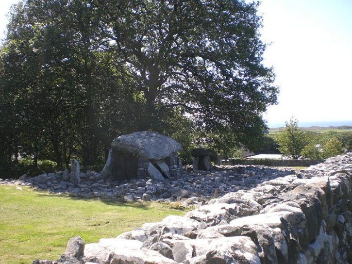
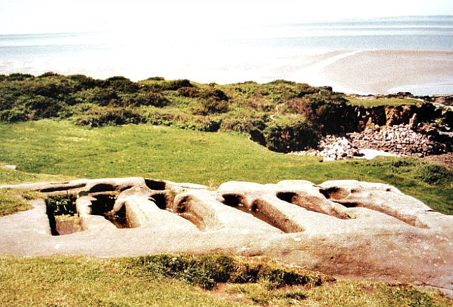
11th century Castle Haugh, Lancashire, (from the north).
OS Grid Reference: SD 82997 50775. High above a bend in the river Ribble, ¼ of a mile south of Paythorne Bridge, Newsholme, Lancashire, is a large tree covered mound with a deep ditch running part-way around it, which is known as Castle Haugh or Cromwell’s Basin. The site is 1 mile north of Gisburn and close to the A682 Hellifield road. It is about ¼ of a mile further along from Little Painley burial mound. Castle Haugh is actually a late 11th century Norman motte that is quite well preserved, although the ditch on the river-bank side has slid downwards. Often described as a medieval ringwork or earthwork. It was quite obviously a hastily constructed fortification built by a Norman baron; maybe William de Percy? There might have been a wooden structure on top of the mound in the early years, but that this was soon destroyed by Scottish raiders. The bailey, if it ever existed, has long since disappeared. It is best reached by way of a footpath heading south through the woods from Paythorne Bridge. Follow this path for about a ¼ of a mile until you see the mound of trees in the field just up ahead of you. As the mound is on private land it is best to ask the farmer for permission to view it more closely.
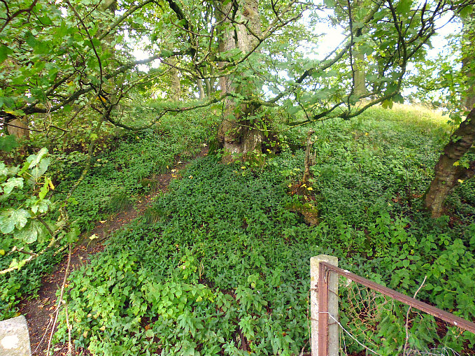
Castle Haugh Motte.
Castle Haugh Motte.
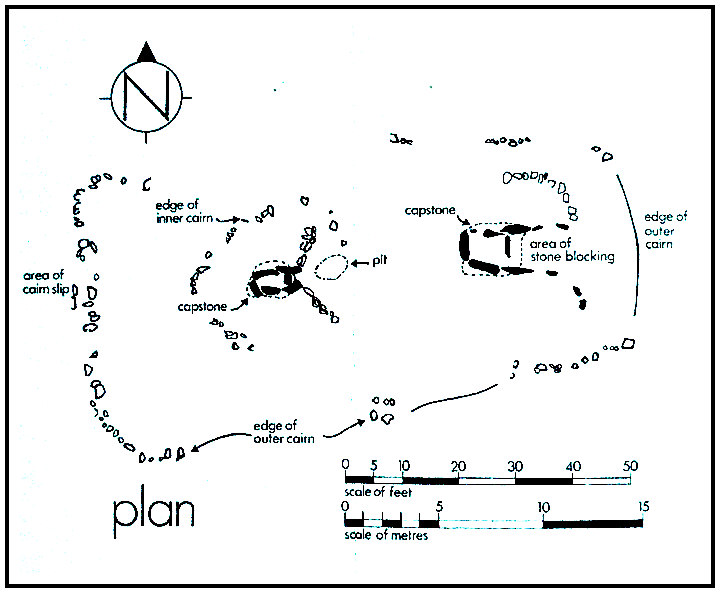
Authors John & Phillip Dixon (1990) say of the site that: “Castle Haugh is sited on the edge of a high scar one hundred feet above the River Ribble south of Paythorne Bridge. It comprises a large mound and surrounding ditch. The central motte is small, twenty-five feet high, and it is evidently defensive, as it still retains the hearthen breast work round the top, silted down so as to convert the inner area into a shallow cup. The dry ditch round it, seven feet deep, is nearly perfect, except for a portion that has slipped down the scar. The situation is a commanding one, high above the Ribble, where Ribblesdale meets Craven and Blackburnshire.
The authors go on to say that: “Some historians have suggested that Castle Haugh earthwork is what remains of an early castle of the Norman Baron, Roger the Poitevin, mentioned in the Domesday entry for Barnoldswick: “”In Bernulfeswic (including Ellenthorpe), Gamel (the English predecessor of Berenger de Todeni) had 12 carucates for geld. Berenger de Todeni held it, but now it is in the castellate of Roger the Poitevin.” This may be a reference to Castle Haugh, or to Clitheroe Castle, or to some other now lost castle in the West Craven District.
“Others suggest that the reference to a ‘castellate’ is not to an actual structure but a term used to indicate that a manor was in the honor of a lord. Many other words were used vaguely in the 10th and 11th centuries, before the establishment of an accepted terminology. The word ‘castelli’ is proven to have been used to refer to the whole of the lord’s estates, before the word ‘honor’ became the norm. This could well be the case with the Barnoldswick Domesday reference. However, the debate goes on.”
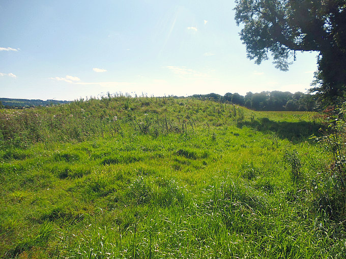
Castle Haugh. The deep grassy ditch.
Castle Haugh. The ditch and motte.
W. R. Mitchell (2004) says that: “When Norman rule began the valleys of Ribble and Hodder were already well settled, with evidence for the nuclei of many villages. William de Percy, who had arrived on the scene in 1067, was awarded a hundred Yorkshire manors, including Gisburn and Bolton-by-Bowland. Yorkshire territory was subsequently known as Great Bowland. Chipping — the Chipenden of Domesday Book — was not counted with Bowland until early in the 12th century, becoming part of the Lancashire share, otherwise called Little Bowland. The Bleasdale area, although not mentioned in the Domesday survey, was held by Tostig and included in the Forest of Lancaster. As such it was royal property.
Jane Sterling (1974) says: “In the wholesale share-out of lands after the victory, William the Conqueror gave lands to Roger of Poitou, the third son of Roger de Montgomery, Earl of Arundel and Shrewsbury, a cousin of the Conqueror and who had fought with distinction at Hastings. Roger’s estates included the lands between the Ribble and the Mersey, Lonsdale and Furness. Amounderness (the Fylde) was added to these possessions in 1072. To this gift of land to Roger de Poitou we can trace the rather odd geographical distribution of the later county of Lancashire to include the southern part of the Lake District which would have more geographical affinity with Cumberland and Westmorland — an anomaly rectified by the new county boundaries. But military considerations took precedence over others and Roger de Poitou who became involved in a military campaign against the Scots was presumably given the land in the Cartmel and Furness areas so that he could defend the main route of the Scottish invasion — across the sands of the Leven and Kent estuaries.
Sterling goes on to say that: “The Domesday Survey is a unique document. It was compiled mainly for the purpose of aquainting William I with the extent and tax potential of his new realm. Though by no means a comprehensive survey of the country it is an invaluable record of England in the early years of Norman domination. Lancashire at this time had still not emerged as an administrative county and the entries which cover the present day Lancashire are included partly in the survey of Cheshire and partly in “”the King’s lands in Eurvicshire (Yorkshire)””.
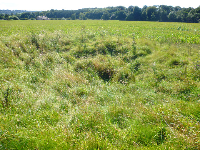
Castle Haugh. On the summit of the motte.
Castle Haugh. On the summit of the motte.
I am informed by Nick Livsey that the large mound of Castle Haugh was built on top of a Bronze Age burial mound. This occurred because a site was quickly needed for a defensive castle (motte) to be situated close to the river Ribble. Nick says that: “Its a bronze age burial mound that was re-used as a motte and bailey castle (timber construction) around 1080; but its a shame that the river Ribble has eaten 1/3 of it away, and that a motte and bailey was constructed upon it and, as far as I know, it hasn’t been archeologically excavated, well not by professional archeaologists anyway.” Nick also adds that “the new Norman lord used the easiest available mound that offered good views down and up the Ribble and also the road system; the fact that there are so many burial mounds near here is because of the River Ribble was a watery liminal place between the living and the dead. You often find burial mounds on parish boundaries or next to lakes or rivers.”
Sources and related websites:-
Dixon, John & Phillip, Journeys Through Brigantia, (Volume One), Walks in Craven, Airedale and Wharfedale, Aussteiger Publications, Barnoldswick, 1990.
Mitchell, W. R., Bowland And Pendle Hill, Phillimore & Co. Ltd., Chichester, West Sussex, England, 2004.
Sterling, Jane, Dark Age and Norman Lancashire, Dalesman Publishing Company Ltd., Clapham, North Yorkshire, 1974.
Thanks also to Nick Livsey for his input.
https://historicengland.org.uk/listing/the-list/list-entry/1012521
http://www.matthewpemmott.co.uk/2007/08/castle-haugh-gisburn.html
http://www.castleuk.net/castle_lists_north/103/gisburn.html
http://historicalbritain.yolasite.com/mottes.php
© Ray Spencer, The Journal Of Antiquities, 2017.

