The Journal Of Antiquities

Ancient Sites In Great Britain & Southern Ireland


1 Comment

Delf Hill Cairn Circle, Extwistle Moor, Lancashire

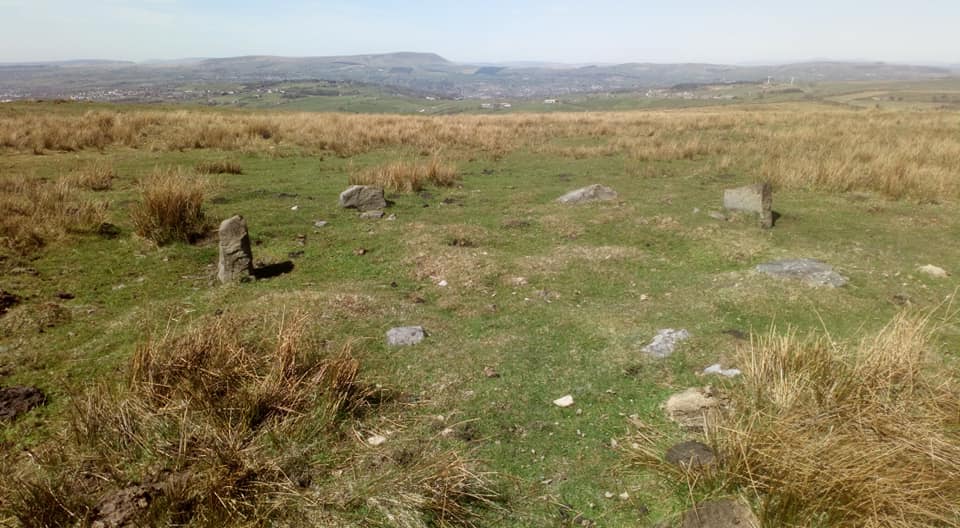
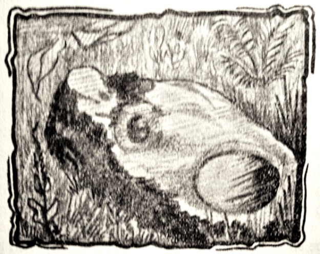
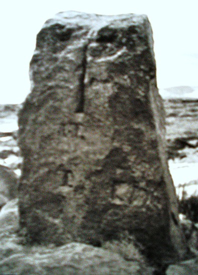
Delph Hill Cairn Circle. Photo is courtesy of Robert Smith.

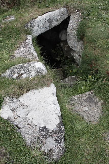
NGR: SD 9006 3373. On the moors to the east of Burnley some 2 miles north-east of Wors-thorne at Hellclough Head is the prehistoric site known as Delf Hill Cairn Circle. The site can be reached best via Haggate and Cockden, then along Shay Lane, Monk Hall lane, and then by walking due south-east across Extwistle Moor to the concrete trig pillar no 2049 on Delf Hill, which is 378 feet. About 77 metres to the east of the trig point lies the low mound forming the cairn with small stones jutting out of it, close to a drystone wall. The area around Extwistle Moor abounds with tumuli, cairns and ancient earthworks,  and so it is well worth having a good look around. The Lancashire town of Burnley is 3 miles to the west and Nelson is roughly 3 miles to the north-west – as the crow flies!

Delf Hill Collared Urn [Courtesy of Donald Jay]

Delf Hill Collared Urn (Courtesy of Donald Jay)

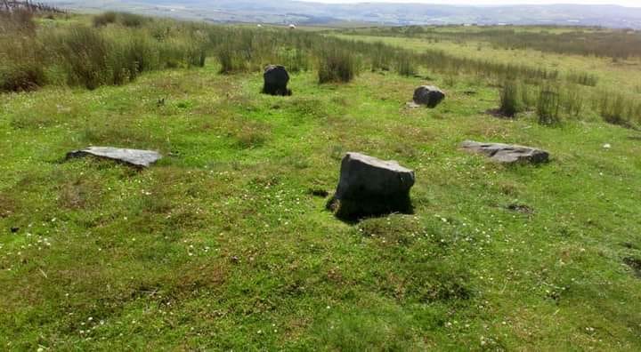
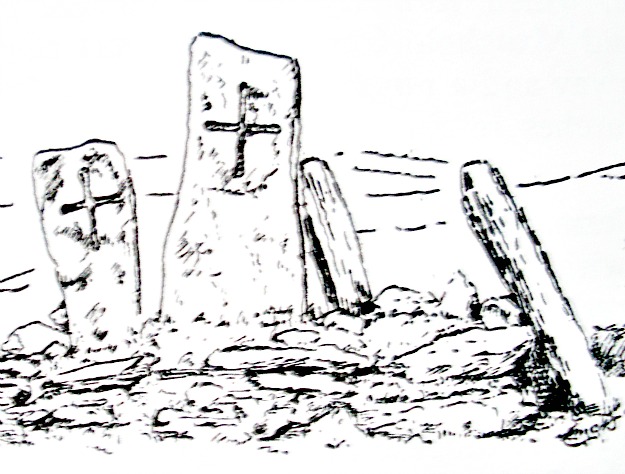
Delph Hill Cairn Circle (close-up). Photo by Robert Smith.

The cairn circle, sometimes wrongly called a stone circle, covers an area roughly 5-6 yards in diameter with a central, small mound and ditch, while the outer low bank has 6 small stones jutting out of it, 2 of the stones are still in an up-right position.  The stones vary in size between 12 inches to 18 inches high. Originally there were 7 stones here, but, this one was probably robbed away or used in the wall nearby. At the centre of the cairn circle a cist-type burial was exca-vated with two small urns containing bones, charcoal and flints inside a small chamber or pit surrounded and topped by stone slabs. The two small funery urns were of the collared ‘Pennine type’ with faint patterning and stippling on their sides, which probably date from the Bronze-Age. Recent quarrying around the cairn circle has luckily not caused much damage, though farming methods are another kettle of fish!

In the same area there are prehistoric earthworks at Twist Castle, Beadle Hill and Swinden, and there are numerous burial sites (tumuli) on and around Extwistle Moor.

Sources:-

Gomme, G.L., The Gentleman’s Magazine Library-Archaeology-Part 1, Houghton & Mifflin Co., Boston, 1886.

Thanks to Robert Smith on Facebook for letting me use the two colour photos (above). These photos are copyright © Robert Smith.

Thanks also to Paul Bennett, The Northern Antiquarian, and to Mr Donald Jay of Nelson for the use of the image.

Copyright © Ray Spencer, The Journal of Antiquities, 2013 (up-dated 2021).


St Anno’s Church, Llananno, Powys, Wales.

English: St Anno's Church, Llananno This churc...

St Anno’s Church, Llananno (Photo credit:  Ann Roberts, Geograph)

OS grid reference SO 0956 7434. Roughly half-way between Llanbadarn Fynydd and Llanbister on the busy A483 Newtown to Llandridod Wells road, in the Ithon Valley and formerly in Radnorshire, but now Powys, is the hamlet of Llananno with its little parish church of St Anno, which is situated above the eastern bank of the river Ithon. The church is a rebuilt 19th century building on the site of a medieval church and, possibly an even earlier Celtic monastic foundation. But the beauty is inside the charming little church. This is a late medieval carved wooden rood screen and loft, which is said to be the best example of its kind in the whole of Wales. Nothing much is known about St Anno, Annu, Wanno or Wonno to whom the church is dedicated, but there are one or two theories about him/her. It could also be a dedication to St Anne, mother of the Virgin Mary? The town of Rhayader is 10 miles to the south-west and Newtown is 14 miles to the north of Llananno.

Llananno Rood Screen (Engraving by Whitman & Bass Collections) 1874.

Llananno Rood Screen (Engraving by Whitman & Bass Collections) 1874.

In 1876-77 the church was rebuilt and the interior restored to what we see today – stonework from the older church being incorporated into the newer Victorian-style building. The famous carved rood screen and loft was taken out and completely restored by craftsmen. In 1880 it was returned to the church and put back exactley as before, but more beautiful than ever with all the intricate wood carvings looking as though they had just been carved. Historians originally thought the screen had come from Abbey Cwmhir at its dissolution in 1536 but, in fact, it was made in about 1500 by the Newtown school of woodcarvers, and so it is Late Gothic in style and had survived the Reformation.

The screen is richly carved with vines and fruits, including pomegranates, oak leaves and acorns, trees, plant stem foliage and berries; the fine tracery work is also beautifully and delicately carved. There are also two scaly, serpent-like animals – having a Greek mythological look about them. The rood loft, above, (sometimes called a gallery) has a long line of canopied niches containing carved figures. Christ is in the middle, while at either side there are apostles, saints and angels. More recently further work was carried out on the rood screen, a process which was finally completed in 1960.

Also of interest in the church is the medieval holy water stoup beside the door for the use of parishioners to dip their fingers in when entering the church, the medieval piscina (for the washing of sacred vessels) on the wall near the altar, and the carved pews with bench ends are from the 17th century; the font is of the 15th century. The churchyard is rectilinear in shape but appears to be built over and on an earlier curved enclosure, which still shows at the north and south sides, suggesting that the site is an ancient one dating back to before the Norman Conquest. All in all a very nice place to visit, if only to walk around the churchyard or sit in the church itself where peace and quiet can be found and, to be astounded by the lovely carved, late medieval rood screen. What a delight!

The dedication of the church to Anno (Annu), an 8th century saint with a feast-day in some calendars on 20th May, is somewhat uncertain, but he could be one and the same as St Wanno or Wonno, whom has a second dedication at Newborough, Anglesey, and to be identical with St Wonno or Gwynno of Wonastow, near Monmouth, who died in 629 AD and is recorded as being a Celtic missionary in Cornwall under the name of St Winwaloe at the village of Gunwalloe and, to have eventually become an abbot in Brittany, but this is by no means a certainty because “his” feast-day falls on 3rd of March. We may never really know.

Sources:-

Zaluckyj, Sarah & John., The Celtic Christian Sites of the central and southern Marches, Logaston Press, Herefordshire, 2006.

Gregory, Donald., Country Churchyards In Wales, Gwasg Garreg Gwalch, Llanrwst, Gwynedd, Wales, 1991.

Spencer, Ray., A Guide to the Saints Of Wales and the West Country, Llanerch Enterprises, Felinfach, Lampeter, Dyfed, 1991.

Whitman & Bass., (Collections), Historical & Archaeological Relating to Montgomeryshire and its borders, Vol VII, p 61, Powys Land Club. 1874.

Copyright © Ray Spencer, The Journal of Antiquities, 2013.

.


St Warna’s Well, St Agnes, Scilly Isles

OS grid reference SV 8804 0077. Above the rock-strewn shoreline of St Warna’s Cove at the south-western side of St Agnes, Scilly Isles, and tucked away beside a coastal trail and field enclosure at the far north-eastern edge of Wingletang Down, is St Warna’s Well. It is almost certainly a natural spring that was Christianized by the presence of St Warna back in the so-called Dark Ages – the 5th or 6th century AD, although nothing much is known about him or her, I’m sorry to say.

St Warna’s Well, Scilly Isles (by F. Gibson).

The well is situated under a little grassy mound and a few steps go down into the dark, stone-lined chamber, while its roof is a slab of stone and its outer sides, especially at one side, are constructed of larger lumps of flat stones. In days gone by pins were thrown into the well and a wish made in order that a ship would be steered away from treacherous rocks, or on the other hand, a bent pin (or several bent pins) thrown into the water and wishes made ‘for a ship to be guided onto the rocks and wrecked so that the booty could be plundered by the locals’. Once washed ashore the booty was regarded as ‘belonging to the islanders’. St Warna is patron saint of shipwrecks, oddly enough! But despite that, the well was visited by pilgrims hoping to obtain some miraculous cure for certain ailments – for its waters were long regarded as being curative.

According to legend, St Warna, a female saint sailed from the south coast of Ireland to the Scilly Isles in a coracle made of wicker and covered in hides; another legend has it that she sailed across the sea in a wicker basket! However she, or he, sailed here, St Warna lived beside the well and imparted her/his holiness to the place. I don’t know whether there was ever a chapel on this site, but it’s possible there once was long ago. We know next to nothing with regard to St Warna – could she have been one of the many followers of St Bridget of Kildare in Ireland, or if a “he” maybe a follower of St Patrick? We just don’t know, unfortunately. There have also been very “tentative” efforts to link the saint with a Celtic goddess of the sea. Anything’s possible, I suppose. One suggestion being that St Warna was a female saint of the 2nd-3rd century AD.

F. Gibson says that: “This bay is steeped in legend. Tradition tells us that Santa Warna came from Ireland in a wicker boat covered with hides and landed in this bay. A holy well marks the spot. The inhabitants used to show their devotion and gratitude to the saint by visiting the well on the day following the twelth day, performing superstitious ceremonies, which of course were followed by the customary feastings and rejoicing. By the glory of nature Santa Warna herself is carved in rock. She is best seen from the southern side of Little Porth Askin cove.”

Sources:-

Gibson, F, Visitors companion to the Isles Of Scilly, (no publisher and no date).

Saint Warna's Well

https://en.wikipedia.org/wiki/Wingletang_Down_(St_Agnes)

Colquhoun, I., The Myth of Santa Warna (The Glass) No 1 , Summer, Unpaginated.

Guide to the Natural History of Scilly – Nature Trails and their habitat, St Ives, Cornwall, England.

https://thejournalofantiquities.com/wp-content/uploads/2013/07/6ea91-115_115.jpg

© Ray Spencer, The Journal of Antiquities, 2013 (up-dated 2019).

.


1 Comment

St Orland’s Stone, Cossans, Angus, Scotland

English: St Orlands Stone. Details of the symb...

(Photo: Wallace Shackleton Wikipedia)

OS grid ref: NO 4008 5002. Roughly half-way between Kirriemuir and Forfar in a farmer’s field near the ruined Cossans farm stands the 8th century Pictish symbol stone known as St Orland’s Stone, but also called Cossans Stone and Glamis Manse No 3. Now fenced off the stone looks rather forlorn on the borderline of two fields, but originally a chapel stood on this site that was associated with the un-known Pictish saint called Orland, and also a number of cist-type graves from the Dark Ages or earlier were excavated here in 1855. The stone may have marked the burial place of St Orland himself? Originally the stone and chapel would have stood on a raised area of land surrounded by marshland. Today the stone is more or less in the middle of nowhere!

There are a number of footpaths and tracks heading off from the A928 and A926 roads towards the stone, but by following the path of the disused railway line from the A928 for just over a mile to the hamlet of Cossans is just as good because you can see the monument in the field to the east. Glamis is 2 miles to the south-west, whilst the town of Forfar is 4½ miles to the east along the A94.

The red sandstone slab is a Pictish Class II monument and stands to a height of 7 feet 10 inches high by 2 foot 4 inches wide, but it has had to be clamped around it’s edges by iron bars that look rather unsightly, though if that’s what it takes rather than the monument collapsing, so be it, because there are some large cracks and a small hole in the stone at the edge. It is sculptured on both sides with some extraordinary Early Christian carvings and Pictish symbols, dating probably from about the 8th century AD. The stone slab is one of four Pictish antiquities that make up the Glamis Manse collection; two others (Nos 1 & 2) being within half a mile of Glamis village, the other stone (No 4) being in the Meffan Institute at Forfar.

The front face has a well-sculptured ringed-cross (in high relief) that runs from top to bottom with faint interlacing (in low relief) formed by spirals and other strange pattern-work in and around the cross, while the reverse side has a hunting scene with men riding on horses, six men in a boat, other human figures, two hounds, serpents, and two animals (bulls) attacking each other at the bottom. In the boat at the far right is what could be Christ with his four evangelists Matthew, Mark, Luke and John. The two serpents with fish-like tails take up much of the reverse side – their jaws holding what could be a human head? Also, the well-known Pictish symbols of crescent and V-rod and double disc and Z-rod.

Sources:-

https://en.wikipedia.org/wiki/St_Orland%27s_Stone

Sutherland, Elizabeth., The Pictish Guide, Birlinn Limited, Edinburgh, 1997.

Childe, Gordon, V., Ancient Monuments Vol VI SCOTLAND Illustrated Guide, H.M.S.O., Edinburgh, 1959.

http://canmore.rcahms.gov.uk/en/site/33868/details/cossans+st+orland+s+stone/

.


1 Comment

Our Lady’s Well (Ladyewell), Fernyhalgh, Lancashire

By Andrew Henderson

OS grid reference SD 55612 33622. Our Lady’s Well (Ladye Well) at Fernyhalgh can be reached along a narrow country lane (Fernyhalgh Lane) to the east of the A6 and M6 motorway, some 4 miles north of Preston. Fernyhalgh is a hamlet situated between the villages of Broughton and Grimsargh, with pleasent countryside on all sides. The holy well of Our Lady is in the garden of the 17th century Ladywell House which houses a Roman Catholic chapel and retreat centre. It is located at the side of the secluded Fernyhalgh Lane that runs south for about ½ a mile from D’Urton Lane. The entrance to the well and shrine is through a little gate almost hidden at the side of the retreat centre building.

There was a chapel on this site way back in 1348 and possibly a shrine dating back to the 11th century. The spring itself is obviously a Christian one, with it’s dedication to Our Lady the Blessed Virgin Mary, and possibly a pre-Christian spring. According to the legend, in about 1471 a merchant sailing across the Irish sea was caught in a terrible storm; afraid that he was going to drown he prayed to the Virgin Mary and vowed that if his life was saved he would undertake some work of devotion to Her. Soon the storm cleared and he found himself washed-up but safe on the Lancashire coast, but he had no idea where he was. At that moment a heavenly voice spoke to him and told him to find a place called Fernyhalgh and there build a chapel at a spot where a crab-apple tree grew the fruit of which had no cores, and where a spring would be found. He began to search around for this sacred place but no-matter how much he tried he could not find it.

The merchant found lodgings in Preston and, was about to give up altogether, when he overheard a serving girl at the inn. She started to explain why she was so late on arrival. She went on to say that she had had to chase her stray cow all the way to Fernyhalgh. The merchant asked her if she could take him to this place. In a short time he discovered the apple tree with fruit bearing no cores and beneath it a spring and also a lost statue of the Virgin and child. He set about building a chapel close by in memory of Our Lady and soon pilgrims were visiting the holy well and receiving miracles of healing. However, during the time of persecutions in the reign of King Henry VIII and through to that of King Edward VI the well was abandoned and left derelict, and the chapel itself was sadly demolished.
.
Lady Well, Fernyhalgh

Lady Well.

The holy well of Our Lady was, however, fully restored in the late 17th century and a new chapel (the Martyrs Chapel) was built in 1685 when persecutions towards Catholics had eased. Again the place became a place of pilgrimage and many miraculous cures were being recorded there. The chapel (which is upstairs in Ladywell House) was used by religious sisters as a place of retreat and is still used today; it houses some of the relics of the English Catholic martyrs. Today, it is a renowned Roman Catholic pilgrimage centre and Marian Shrine, with thousands of visitors coming from far and wide.

The holy well stands within a rectangular enclosure with steps descending down; the well itself being a small square-shaped basin overlooked by a statue in a stone-niched surround of the Virgin Mary holding baby Jesus. The well and shrine were restored to what we see today between 1905-1954 by the religious sisters, and it is still very well cared for by volunteers in the local Catholic community, with flowers usually adorning the well-shrine during the Summer months. Coins are sometimes thrown into the well although ‘it is not’ regarded as a “wishing well”. Visitors are always welcome and, you don’t have to be a Catholic, everybody regardless of what religious persuasion they might be can visit the well and shrine.
.
Edward J. Popham, writing in 1988, says of this place: “To the north of Watling Street road and near to Preston is a place known as “Fernyhalge”. The name is a combination  of two Anglo-saxon words, namely “ferny” meaning ancient or old and the word “halgh” which means shrine. In the Prologue to Chaucer’s “Canterbury Tales”, he states that in the spring people  go on pilgrimage to “ferna halwes” (ancient shrines). Why the Anglo-saxons called this place an “Ancient Shrine” is unknown; but they must have had a good reason for doing so. The most reasonable explanation  is that on this site once stood an ancient shrine to a Roman Goddess; but that after the King of Northumbria was baptized at York on Easter Day in A.D. 627, the site was converted into a shrine to Our Lady. It is generally accepted that the shrine of Our Lady at Glastonbury is the oldest Marian shrine north of the Alps; but it is quite possible that the Shrine of Our Lady of “The Ancient Shrine” at Fernyhalge may be older. This shrine was regularly and frequently visited by Catholics in Penal Times. Their faith in Mary was undoubtedly a source of their courage and fortitude.”
.
Sources and related websites:-
.
Bord, Janet & Colin Sacred Waters, Paladin Books, 1986.
Popham, Edward, J., (assisted by Margaret Panikkar), The Osbaldeston Saga, 1988. With illustrations by Andrew Henderson.
 
Popham, Edward, J., Where Shall We Go In The Ribble Valley, The Salford Catholic Truth Society, 1993.
Fields, Ken, The Mysterious North, Countryside Publications, 1987.
With thanks also to The Northern Antiquarian.
                                                            © Ray Spencer, The Journal Of Antiquities, 2017.


2 Comments

St Materiana’s Church, Tintagel, Cornwall

Roman Milestone, Tintagel, Cornwall

Roman Milestone, Tintagel, Cornwall

OS grid reference SX 0506 8845. On Vicarage Hill Lane at Glebe Cliffe close to the seashore and just to the west of the famous Arthurian village of Tintagel, north Cornwall, stands St Materiana’s church, also called Mertheriana’s, an ancient religious foundation that is now the parish church. At the west end of the south transept there is a Roman milestone commemorating the Emperor Licinius which dates from the 4th century AD. The inscription on the stone reads IMPCG VAL LICIN (the Emperor). This would be Caesar Galerius Valerius Licinianus (308-24 AD). This milepost was originally built into the church lychgate (Lower Church Stile) where it had been used as a coffin rest! but in 1888 it was brought inside the church for safety. Another Roman milestone was found at nearby Trethevy village. This has a Latin inscription: IMP C DOMIN GALLO ET VOLUSIANO honouring Gallus* and Volusianus (AD 251-253). *The Roman emperor Gallus ruled together with his son Volusianus.

Also housed inside the church at the west end of the nave is a very fine Norman font bowl which is said to have come from St Julitta’s Chapel in the grounds of Tintagel Castle. The church dates from about 1080 AD and was built on the site of a Saxon or Dark-Age settlement. Much of it’s wonderful carved stonework is from the Norman and medieval periods, especially the north doorway (1080) and the south doorway (1130). The building was restored in the 1870s by J.P.St Aubyn.

St Materiana (Madryn or Madrun) was a 5th century princess from the south-east of Wales who came to live in the area as a nun with some female companions. She founded the first church and, possibly a monastery, at Minster (Talkarn) near Boscastle (SX 1105 9046) some 5 miles to the east of Tintagel. She was eventually buried at Minster with her feast-day on 9th April. Her tomb existed in the ‘mother church’ of Boscastle (which is also dedicated to her) in Minster Woods about half a mile east of that village, in the Valency Valley, up until the Reformation.

According to the ‘Legend’, Materiana was the daughter of Vortimer the son of the British King Vortigern (of Wales), and later she married Ynyr, King of Gwent. However, she decided to lead a religious life and with her companions Marcelliana and Uliet (Juliot or Julitta) sailed to north Cornwall where they set about their mission to covert the local people to Christianity. St Uliet (Juliot) founded a small monastery on the eastern promontory of Tintagel Head, opposite Tintagel Castle, circa 500 AD, which was excavated by archaeologists in the 1930s. There is a church dedication to St Uliet at Llanilid in Mid Glamorgan, south Wales, where she is described as being one of the many daughters of King Brychan of Brecknock (Brecon) whose second wife was called Marcella – maybe St Marcelliana? St Materiana’s holy well can still be seen in Minster churchyard.

Aelnet's Cross, Tintagel, Cornwall

Aelnet’s Cross, Tintagel, Cornwall

Back in the village of Tintagel itself and in the grounds of the former Wharncliffe Arms Hotel (now new flats) on Fore Street stands a 5th-6th century Celtic cross. Although the cross dates from that time the carvings and an inscription are thought to have been carved in the 10th or 11th century? Originally the cross, which is just over 4 feet high, stood at nearby Trevillet where it had been used as a farm gatepost and has therefore suffered some damage.

It has wheel-head crosses on both faces and also Latin inscriptions. On the front face there is the inscription: AELNET FECIT HAN CRUCEM PRO ANIMA SUA or ‘Aelnet made this cross for the sake of his soul’. On the opposite face the names of the four Evangelists MATHEUS, MARCUS, LUCAS AND JOHANES with their beaded faces being carved into the angles of the expanded cross-arms.

Sources:-

Pevsner, N & Radcliffe, E., The Buildings Of England, Cornwall, Penguin Books, 2nd edition, 1970.

Spencer, Ray., A Guide to the Saints of Wales and the West Country, Llanerch Publishing, Felinfach, Lampeter, Dyfed, Wales, 1991.

Ashe, Geoffrey., The Quest for Arthur’s Britain, Paladin Books, St Albans, Herts, 1971.

.


The Ruthwell Cross, Dumfries And Galloway, Scotland

OS grid reference NY 1006 6821. About ½ a mile to the north of Ruthwell village in the Scottish borders, near Annan, is Ruthwell parish church and housed within is The Ruthwell Cross, a quite spectacular Anglo-Saxon (Northumbrian) cross dating from the late 7th to early 8th century, and which also has Norse carvings, some Germanic influence and a runic inscription. It is considered by historians to be one of the most important of the early Christian, Dark-Age crosses in Europe. The church stands beside the country lane to Newfield, close by Aiket farm, a short distance to the east of the B724 Annan road. Dumfries is 6 miles to the north-west.

The cross stands in the church apse that had to be specially built to accomodate the monument that is 18 feet (5.3 metres) in height; the base of the shaft being set below the level of the floor. Originally it stood outside in the churchyard where in 1642 it was toppled and broke up by the Scottish Church authorities, but in 1800 a local clergyman, Reverend Duncan, realising it’s importance decided to assemble the pieces of cross-shaft which was finally placed inside the church for safety in 1823. A large part of the cross-head was missing and badly damaged, especially the arms, and so it had to be entirely rebuilt with what fragments were available, but I must say a fairly good job has been done. The rest of the tall cross-shaft had also been broken in several places and has had to be rebuilt with the original sections set into their proper places and, once again a brilliant job has been done.

The Ruthwell Cross

The Ruthwell Cross (front)

The north face (front) of the cross-shaft has some pretty astounding carvings. Christ is shown in magesty (glory) standing upon the heads of two beasts, a sign of his triumph over evil; also Christ’s crucifixion, St John the Evangelist with his eagle, St Matthew, St John the Baptist holding the Agnus Dei (Lamb of God) with a cruciform numbus around it’s head and a cross in it’s front foot; also a vexillum – a cross-inscibed banner. Around the front edges there are 18 of the earliest ‘extant’ Northumbrian dialect verses from the epic English poem ‘The Dream of The Rood’ that is in both runic and Latin. In the 7th century the Scottish borders came under the control of the Northumbrian kingdom of Deira. On the opposite (south) face St Mary Magdalene tenderly washes (annoints) the feet of Christ. On the west face another runic inscription along with some beautifully carved and very delicate interlinking vinescrolls, incorporating many strange looking creatures; the east face also has interlinking vinescrolls. Other figures on the south face include two figures embracing, often thought to be Mary and Martha, an archer, the Virgin Mary and baby Jesus on a donkey. Other carvings on the cross include various strange animals and human figures, two of which could be St Paul & St Anthony breaking bread?

Ruthwell Cross (front)

This truely is a masterpiece of Early English Anglo-Saxon craftsmanship with Scandinavian and, possibly Germanic influence, that can only be equalled by a few of the Celtic high crosses in Ireland. When the Ruthwell Cross was first set up it would have been painted in some quite vivid colours – what a sight it must have been for the early Christians of northern Britain. There is some uncertainty about the age of the cross, but it was probably carved somewhere between 660-700 AD?


Sources:-

Bord, Janet & Colin., Ancient Mysteries Of Britain, Diamond Books (Harper Collins Publishers Ltd)., 1994.

Breeze, David, J., Historic Scotland, Batsford Ltd., London, 1998.

The Automobile Association, Illustrated Road Book Of Scotland, 1963.

Humphrey, Rob; Reid, Donald & Tarrant, Paul., Scotland – The Rough Guide (4th Edition), The Rough Guides Ltd., London, 2000.

Bottomley, Frank., The Church Explorer’s Guide, Kaye & Ward, London, 1978.

.


The Gloonan Stone, Cushendun, Co. Antrim, Northern Ireland

The Gloonan Stone, Co.Antrim

The Gloonan Stone (Rosemary Garrett)

Irish grid ref: D2336 3218. A couple of miles to the west of Cushendun village, Co. Antrim, along the Glendun road and opposite Craigagh church can be found The Gloonan Stone, or St Patrick’s Knee-Stone, which is actually one of literally hundreds of balluan stones that are to be found in Ireland, and is said to date back to the time of the Irish patron saint, though, it’s more likely to predate him. The Church of St Patrick and St Brigid across the road is worth looking at and, in Craigagh Woods to the west, there is an ancient, carved altar stone (Altar In The Woods) that has been frequented by the local Catholic community for hundreds of years. The village of Knocknacarry is roughly ½ a mile to the south-east on the opposite side of the Dun river, while the coastal village/townland of Cushendall is 8 miles to the south-west on the A2 road.

At the opposite side of the Roman Catholic church of St Patrick and St Brigid on Glendun Road at the side of the entrance to the farm stands the famous Gloonan Stone with a large hollowed out, circular hole and a smaller circular depression that is considered to be one of the more famous of all the balluan stones in Ireland. The name Gloonan (gluin) means knee-stone, this one in particular being associated with the great St Patrick. Of the two holes the deeper one often has water inside it that is locally considered to be miraculous – in fact it is, perhaps, sometimes erroneously called St Patrick’s Well, the water having the ability to cure warts and other skin problems. Legend says that when St Patrick was travelling this way in the 5th century AD he stopped here, knelt down on the stone and drank the water, thus making the water from that time onwards, miraculously curative; his knee apparently caused the smaller, circular depression, at least that’s the ‘legend’. Other possibilities being that the stone was used by Celtic missionaries as a sort of baptismal font, another that it was used for the grinding of corn?

In St Patrick and St Brigid’s Catholic church, dating from 1917, across the road there is a lovely Rose window and also some other interesting stained-glass. Inside the entrance stands a replica of the medieval Ardclinis crozier, the original one being in the National Museum, Dublin. This bishop’s crozier came from the monastic site at Ardclinis near Waterford and could well be associated with St Patrick?

In Craigagh Woods to the west stands the famous ‘Altar In The Woods’, an oval-shaped stone set into a rock with the crucified Christ and a winged cherub carved onto it; there used to be an inscription but this has worn away. The stone was brought here by boat from the island of Iona, western Scotland, in the 1500s by local people in the days of Penal Law. The Local Roman Catholic community came to worship at this rocky site long before the carving of Christ as it was well hidden by the oak trees, and every June crowds of people with ‘great faith’ still come to worship here at the altar and at the little chapel that stands on the site of an earlier religious building, probably of a medieval date.

Source:-

Garrett, Rosemary., Cushendun, and the Glens of Antrim, J.S. Scarlett & Sons, Ballycastle, Northern Ireland, 1956.

Links:-

http://www.cushendunweb.co.uk/St%20Patricks/stpatshome.htm

http://www.heartofthecausewaycoastandglens.com/Portals/0/downloads/HeartOfAntrimGlensVisitorGuide.pdf

Copyright © Ray Spencer, The Journal of Antiquities, 2013.

.


St Patrick’s Chair, Marown, Isle Of Man

St Patrick's Chair, Marown.

St Patrick’s Chair, Marown.

OS grid reference SC 3050 7650. In a field called Magher-y-Chairn just west of the B35 road between Braaid and Crosby, in the parish of Marown, Isle of Man, and north of Garth farm are three standing stones stood together that are known locally as St Patrick’s Chair or Chairn-y-Pherick. Two of the slabs have early Christian crosses carved on them. In the same field is a holy well. Local legend has it that St Patrick came to preach here in the mid 5th century AD, but actually there is no hard evidence to support this. However, three Irish bishops – namely St Runius (Ronan), St Lonan and St Connachan (Onchan) are said to have lived and possibly died here. Indeed, they may lie in St Runius’ churchyard at Kirk Marown, about half a mile to the north-east. Also in that churchyard at the east end of the old church are the remains of a keeill, a primitive chapel dating from the early Christian period. The parish of Marown (Ma-Ronan) takes it’s name from the saint; and the town of Douglas is 4 miles to the east.

Originally there were five granite standing stones here but two have now fallen over and they lie amongst a jumble of other stones that may have once formed a burial site. Two of the slabs have simple but intricately carved thin crosses on their front faces from the early Christian period. It would appear that early missionaries have christianised these stones at some point between the 7th-9th centuries AD, as the standing stones themselves almost certainly pre-date Christianity by a few thousand years, making them prehistoric in age. Was this the meeting place for early Christians, or was it the burial place for an ancient chieftain? who knows! At the south-eastern side of the very same field is a holy well called Chibber y Chairn (Well of the Chair), also known as St Ronan’s Well.

Local legends say that St Patrick himself came here and used the stones as a seat to preach from in the 5th century AD; however, this cannot be substantiated and is thought highly unlikely, but it is likely that Irish bishops preached in front of the stones – one bishop in particular could well have been St Ronan, known locally as St Runius or Runy (Ma-Ronan) who founded a tiny chapel (keeill) a short distance to the north-east in the 7th or 8th century and has given his name to Marown parish. His feast day is still celebrated in the Isle of Man on 7th February. He was apparently third bishop of Man following St Maughold (d 498) who “was” a convert of St Patrick. Whether this St Ronan is one and the same as St Ronan, bishop of Kilmaronen in Lennox, Innerleithen, Scotland, is uncertain, but ‘he’ is credited with attending the famous Synod of Whitby in 664 AD, according to the Venerable Bede.

The remains of the saint’s humble little chapel, built from wattle and daub with earthen walls stone-faced on the inside and roughly measuring 16 feet by 10 feet, can be seen at the east-side of St Runius’ old church. The little building dates from c1200 AD, but was enlarged and then rebuilt in the mid-18th century. It eventually fell into decay only to be restored and reopened again in 1959 by local people. Housed within are some crude Manx-style crosses, one of which was found beneath the porch. Could it be that these crosses once marked the resting places of the three Irish saints? This is certainly a very holy site.

Sources:-

The Manx Museum And National Trust, The Ancient And Historic Monuments of The Isle Of Man, Fourth (Revised) Edition, Douglas, 1973.

Farmer, David., Oxford Dictionary Of Saints, Oxford University Press, Oxford, 2004.

Click on the link http://www.iomguide.com/historical-sites/st-patricks-chair.php

Copyright © Ray Spencer, The Journal of Antiquities, 2013.


2 Comments

Winterton Roman Villa, Old Cliff Farm, North Lincolnshire

OS grid reference SE 9138 1809. At the west side of Winterton, a small town 5 miles north of Scunthorpe, in north Lincolnshire, are the oblong-shaped earthworks of what would have been the quite opulent 2nd-century Winterton Roman Villa, one of two in this area. The site is located behind Old Cliff Farm, just to the west of Roxby road and Top Road (A1077). Normanby Hall Country Park is 1 mile to the south-east, while the Humber estuary is just 2 miles to the north. The Romans called the Humber River Abus Fuvius. In the town of Winterton itself, to the east of North Street, is the site of another Roman villa, or a 4th century Romano-British farmstead, and few miles to the east of the town is the course of the Roman road running north from Lindum (Lincoln) to Eboracum (York) via a ferry across the river to the (civitus) Roman capital of Brough (Petvaria) on the opposite bank of the estuary. The area around Winterton was home to a Roman tile-cum-pottery manufacturing site and also an early mineral extraction site that processed iron ore.

The villa appears to have been built in three seperate stages at different times from the early to middle 2nd century AD up until the mid 4th century AD (the Romano-British period), each newer (ancillary) building being linked via a corridor (aisle) with the most recent part of the villa at it’s western-side measuring roughly 110 by 40 feet with interior dry-stone walls and double rows of roof support posts at 8 feet apart. There was a limestone floor with two large mosaics and a water channel or gulley running beneath that with a hypercaust (underfloor heating system), and some interesting wall paintings. During excavations pottery sherds from the 2nd century AD were found under the mosaic floor. Two stone round houses also stood in the grounds of the villa.

The eastern side of the villa had been, in more recent times, demolished to make way for road widening and, during this road widening in 1968, some 4th-century Bronze workings were found. Workmen also came across a stone coffin with lead lining at the bottom. This contained the skeleton of a woman in her early 20s who may have lived at the villa in Roman times, although a more recent date, perhaps of the Anglo-Saxon or Viking ages, has been given to her?

When archaeological excavations took place between 1958-1967 ‘broadperiod’ pottery sherds from the 2nd century were excavated; also fragments of mosaics, a statue, parts of the hypercaust heating system and a number of other antiquities from the villa site as well as finds from the surrounding area, all of which are now on display in the North Lincolnshire Museum, formerly the Scunthorpe Museum, on Oswald Road in the town.

Just to the east of North Street (the B1207) road in Winterton are the scant earthworks of what is probably another Roman villa, or a Romano-British farmstead-cum-settlement, according to some, from the 4th century AD? This site was discovered in 1953.

Sources:-

Stead, I.M., Excavations at Winterton Roman Villa and other Roman Sites in North Lincolnshire, H.M.S.O. (Dept of The Environment Archaeological Reports no 9), 1976.

Ordnance Survey, Historical map and guide – Roman Britain, (Fifth Edition), Southampton, 2001. 

Click on the link http://www.historyfiles.co.uk/KingListsBritain/EnglandLindsey.htm

Copyright © Ray Spencer, The Journal of Antiquities, 2013.

.


Sweyne’s Howes, Rhossili, Gower Peninsula, Wales

OS grid reference SS 4209 8982. About one and half miles north-east of Rhossili village at the far western-side of the Gower Peninsula – and at the bottom of the eastern scarp of Rhossili Downs – are two ‘former’ portal burial chambers (dolmens), standing around 100 metres (330 feet) apart, and called Sweyne’s Howes or ‘Sweyne’s How’, ‘Swain Houses’ and also ‘Sweye’s Houses’. The place-name Howes or How means or refers to burial mounds or tumuli.

Sweyne was the name of a Scandinavian warlord who lived and died in this area in the 11th century, but the megalithic monuments pre-date him by three thousand years or more. However the chambers (north and south) are now in a poor condition, the northern chamber being the best preserved of the two. Both burial chambers can be reached on footpaths heading north from Rhossili, close to the often windswept Gower coastline. The village of Llangennith lies 3 miles to the north-east, while the city of Swansea is 17 miles to the east on the A4418.

The northern burial chamber or dolmen stands upon an oval-shaped mound which is a cairn measuring roughly 60 feet by 42 feet though it is now in a ruinous condition – as is the chamber. However it’s condition is resonable. Two upright slabs support a capstone that has slipped down on it’s side and, in the middle, there is a fallen upright stone and a smaller recumbant stone. It’s portal has gone. There are slight traces of a kerb and also a few outer stones still (in situ) stand close by. The south burial chamber of Sweyne’s Howes at Os grid reference SS4205 8976 has been largerly robbed away. It’s alomost circular burial mound with a very damaged and jumbled arrangement of stones that make up the cairn measures 70 feet by 50 feet. Nothing much remains of the burial chamber, sadly. The large capstone now lies flat though two of the uprights ‘still’ stand on their own beside it. Both monuments date back at least 5,000 years to the Neolithic period of prehistory 2,000-3,000 years BC.

Sweyne or Swain, was according to legend, a Scandinavian warlord of the early 11th century AD. He was probably the founder of Swansea (Sweyn’s-ey) but he came to live on the western side of the Gower Peninsula and died there. Whether he was buried in one if the mounds that make up Sweyne’s Howes we do not know. It seems most unlikely because these two monuments pre-date him by several thousand years. But there was apparently a king of that name who died in south Wales about c 1014 AD, so there could be some truth in the story. There are other numerous prehistoric monuments in the vicinty of Rhossili Downs, dating from the Bronze-Age to the Iron-Age, that are worth exploring, including cairns, round barrows and a ring-fort.

Sources:-

The Gower Society,  A Guide To Gower, Gower Society Publications, 1989.

Houlder, Christopher, Wales: An Archaeological Guide, Faber And Faber Limited, London, 1978.

The National Trust, The Gower Peninsula (An illustrated souvenir), 1991.

Barber, Chris & Williams, John Godfrey., The Ancient Stones of Wales, Blorenge Books, Abergavenny, Gwent, 1989.

Click on the link for a photo of Sweyne’s Howes north http://www.aenigmatis.com/prehistoric-sites/wales/sweynes-howes-north.jpg


The Gosforth Cross, Cumbria

The Gosforth Cross, Cumbria

The Gosforth Cross, Cumbria

OS grid reference: NY 0720 0360. At the north side of Gosforth village on Wasdale Road, Cumbria, stands the ancient parish church of St Mary, and in the churchyard, the equally ancient and famous Gosforth Cross. The monument is a very tall, slender Anglo-Norse (Scandinavian) high-cross made from red sandstone, dating from the 10th century. It is richly decorated with some very exquisite carvings of Norse gods, Christian symbolism and mythical beasts. The ancient church houses two hog-back tombstones and another carved stone. Whitehaven on the Cumbrian coast is 12 miles to the north-west and the A595 is three-quarters of a mile to the west of Gosforth village. Seascale, the attractive holiday town, is 2 miles to the south on the B5344.

The Gosforth Cross stands at 4.4 metres (14 feet 5 inches) high and is very well-preserved for its age, which is probably 950-1000 AD, the late Anglo-Saxon age. It’s slender shaft tapers away towards the ornate, four-holed cross-head that is also in a relatively good state of preservation. Three-quarters of the cross-shaft N, W, E and S faces are richly ornamented with scenes (in panels) bordered by roll-moulding showing Norse gods like Thor, Odin, Loki, Mimir and Heimdallr, all of whom figure strongly in the famous Norse poems of Edda, but there are also Christian figures too like Christ crucified and symbolism from the early Christian period.

English: Gosforth Cross outside St. Mary's chu...

Gosforth Cross(Photo credit: English Lakes – Wikipedia)

Thor is depicted fishing for the Midgard serpent Jormungandr, Heimdallr is holding his customary horn, Loki appears chained and bound with his protective wife, Sigya below him, and Vioarr is attempting to open the fearsome jaws of Fenrir. Christ appears crucified and also in majesty, a sign of his victory over the pagan gods. There are many strange mythical beasts’ heads that are joined together with interlacing, including a dragon (Surt) and numerous serpents, and also animals such as wolves and deer.

A number of human figures also appear, one is holding a spear, while another has his arms and legs chained with a knot-work cord around his neck in the form of a snake; also a female figure holding a bowl. Horsemen are also quite prevalent with spears. The lower rounded section of the shaft has much plainer chevron-style pattern-work representing the tree of Yggdrasil, while below that the bottom of the shaft is largely devoid of carving. The significance and symbolism of the carvings were first identified by Mr Charles Parker, the antiquarian, in 1886, who later wrote about his findings in a book.

Inside the church of St Mary, a Norman foundation on a Saxon site, there are two carved hog-back tombs (shaped like houses) from the Viking Age, one of which shows Thor once again fishing for the Midgard Serpent, as well as battle scenes and other carvings. Another Anglo-Norse stone in the north aisle called the Fishing Stone, may be part of a cross-shaft or part of an Anglo-Norse frieze? This depicts a deer trampling on the fearsome serpent Jormungandr and dates from the 10th century AD.

Sources:-

Parker, Charles., Ancient Cross of Gosforth in Cumberland, Elliot Stock, 1896.

Bord, Janet & Colin., Ancient Mysteries of Britain, Diamond Books (Harper Collins), 1991.

https://en.wikipedia.org/wiki/Gosforth_Cross

Maxwell, Fraser., Companion Into Lakeland, Methuen, London, 1939.

Copyright © Ray Spencer, The Journal of Antiquities, 2013.

.


2 Comments

The Roman Lighthouse, Dover, Kent

Roman Lighthouse, Dover, Kent

Roman Lighthouse, Dover, Kent (photo credit: Garry Hogg)

OS grid reference TR 3260 4181. At the south-eastern side of Dover, Kent, along Mortimer Road on the promontory called Eastern Heights and in the grounds of Dover Castle, a 12th century Norman stronghold stands a ‘reasonably’ well-preserved Roman Lighthouse or Pharos, dating from around 46-50 AD (during the reign of the Emperor Claudius 41-54 AD) and, just after the invasion of Britain in 43 AD; the Roman army possibly first coming ashore here or further along the Kent coast at Walmer. There was a second Roman lighthouse at Breden-stone on the Western Heights, but nothing much of that remains. The parish church of St Mary-in-Castro, a late Saxon foundation from 1000 AD, stands right beside the Pharos but is not attached.

The Romans built a large fort here in c130 AD in order to guard the harbour and sea route for the fleet sailing from Gaul and through the English Channel. It seems likely they rebuilt the fort in the mid-3rd century. They called the place Portus Dubris or Dubrae, which eventually became the Port of Dover. A Roman road runs north-west from Dover to the Roman town (civitus) at Duruvernum Cantiacorum (Canterbury). There is also evidence to say that the mound and earthworks (hillfort) on which the castle, church and lighthouse stand dates back to the Bronze Age or more likely the Iron Age? The M20 motorway is 12 miles to the west of the town.

Roman Lighthouse, Dover

Roman Lighthouse, Dover

Today, the Pharos is only a four-storey building at 19 metres or around 60 feet high with the top floor section being a medieval restoration, but originally it was six levels high at 24 metres or 80 feet and, maybe even eight levels high, according to some Roman historians? In the 13-14th century the lighthouse was in use as a church bell-tower and it was at this time the medieval stonework was added to strengthen the top 6 metre section, making it look more like a fortified ‘church tower’ with battlements. A flight of stone steps runs up the inside of the structure but is now cut off at the belfry.

After nearly two thousand years the original Roman stonework on the seaward side is looking quite weather-worn and crumbly and the entrance and window openings rather worse for wear, with gaping holes, though the top medieval section is still in a resonable state of repair. A beacon of fire would have burned every night on the top of the lighthouse enabling Roman sailing vessels crossing the channel between Gaul and Britannia to navigate their way into the harbour without coming to harm on the rocky headland. The lighthouse would have been manned all through the night by a regular ‘watch’ of sailors from the Classis Britannica naval fleet galley crews who may have camped beside the harbour and, with the help of slaves they apparently built the pharos as a replica to the design of Emperor Caligula’s (37-41 AD) lighthouse at Boulogne-sur-Mer near Calais on the northern coast of France, which was built in 40 AD; the Classis Britannica themselves coming from that area of Gaul. The fort at Dubris (Dover) was garrisoned by the Milites Tungrecani legion.

Sources:-

Hogg, Garry., Odd Aspects of England, David & Charles, Newton Abbot, Devon, 1968.

Ordnance Survey, Historical map and guide – Roman Britain, (Fifth Edition), Southampton, 2001.

http://www.dover-kent.co.uk/defence/pharos_st_mary.htm

Copyright © Ray Spencer, The Journal of Antiquities, 2013.

.


2 Comments

Aiggin Stone, Blackstone Edge, Lancashire/West Yorkshire

Aiggin Stone on Blackstone Edge, near Littleborough.

OS Grid Ref SD 9732 1713. The Aiggin Stone on Blackstone Edge is best reached via the A58 and is 2 miles to the north-east of Littleborough. This well-defined and quite well-preserved stretch of Roman road going up over Blackstone Edge can be reached on foot, of course, from the A58 and after about half a mile the Aiggin Stone can be seen at the side of the Roman road. Some historians now believe this is a medieval road or trackway that was constructed over the foundations of the Roman road in the 13th century, eventually becoming a packhorse road. The Roman road, if that’s what it really is, with it’s worn flat stones and gulley or channel running down the middle connects MAMUCIUM (Manchester) with VERBEIA (Ilkley) and then EBORACUM (York).

.
The inscribed Aiggin Stone stands in a flat rectangular area amidst a jumble of large recumbant stones and a cairn, and marks the boundary between Lancashire and Yorkshire. It is, in fact, a gritstone pillar standing at nearly 4 feet high, and carved on it there is an incised cross as well as the letters I and T. A plaque says the Aiggin Stone is a Medieval waymarker that is 600 years old. Originally it was 7 foot high but over hundreds of years it has been pushed over, or fallen over, and the lower section broken off. The stone tapers towards the top where the Latin-style cross is carved. A pointed cairn stands beside the waymarker stone, no doubt being added to over hundreds of years by walkers traversing the high-level ancient route between Littleborough and Ripponden, high up on the windswept Pennines moors.
.
Aiggin Stone

Aiggin Stone

These marker stones or waymarkers were used for religious purposes; travellers would stop at the stone and say a prayer for a safe journey over the bleak, windswept moors. Some of these stones were even used by people carrying coffins; the coffin rested here and prayers for the dead would be recited, perhaps a stone or two placed on top of the cairn as well. Just below the carved cross are two letters I and T which obviously have some religious significance, possibly meaning IN TEDIUM or ‘In the Lord we trust’ or ‘In praise of the Lord’. Near the bottom of the stone some more letters: an I or a T and perhaps ED (In Tedium).

.
There are other stones on the moors around Blackstone Edge: The Letter Stones to the south of here, the Hanging Rocks and Rocking Stone near the M62 motorway to mention but a few.
.


The Whalley Crosses, Lancashire

OS grid reference SD 7323 3616. In the churchyard of St Mary & All Saints parish church, off King Street, Whalley, in the Ribble Valley are three late Anglo-Saxon sandstone crosses, one in particular is richly carved, but the other two are now showing signs of erosion and, even damage. They all date from the 10th-11th centuries and are often referred to as being Anglian, though two of the crosses display what is probably Norse influence. The three crosses are often thought to be associated with St Paulinus who came to Whalley in the 7th century AD and used them as preaching crosses, but this is thought unlikely. He may, however, have established the first wooden church here on this very site, though the present-day church is largerly a medieval structure, dating from the beginning of the 13th century.

It is well-worth having a look inside the church because there is, amongst it’s many treasures, a Roman altar with a carving of the god Mars, a grave-stone ‘supposedly’ belonging to John Paslew the last abbot of Whalley abbey who was executed at Lancaster in 1537 for taking part in the Pilgrimage of Grace, and also the tombstone of Peter de Cestria, the only rector of Whalley (1235-96). There is an inscribed Roman stone set into the inner archway over the north doorway that has an inscription: FLAVIUS VOT OMPOSU and is probably from the late 3rd century AD. The yellow gritstone font is 15th century. Outside the church adjacent to the south porch there are two hollowed-out stone coffins from the 13th century and near those a large stone block that may be the base of a Roman pillar. The churchyard sundial on a stepped base bears an inscription: LAT 53 40 AD 1757 and another date 1737 – the dial was purchased in 1738.

The three crosses are as follows:-

Whalley Cross No I

Whalley Cross No I

Cross No I (The Western Cross) is decribed as a panelled cross and is just under 3 metres high (9 foot 6 inches). This cross dates from the late 10th to early 11th century and is the earliest of the three. It may have replaced an earlier wooden, painted cross. It displays a strong Anglo-Norse influence in it’s carvings, although now rather worn. There are six panels on the east face – the third middle panel shows a saint in prayer with up-raised hands, or it may be Christ, standing between serpents; another panel has a pelican and another shows the symbol of eternity ‘The Dog of Berser’ the Christianised Scandinavian emblem representing the creator. In the top panel there is a dove representing the Holy Spirit. And there is also the usual interlacing and pattern-work. The head of the cross, now badly damaged, seems not to be the original though it looks about right for this particular cross; it may, however, have been the cross-head for Whalley cross no III? The base of this cross is now set beneath the ground perhaps to stop the lean!

Whalley Cross No II

Whalley Cross No II

Cross No II (Near the porch) is by far the best preserved of the three at 2.2 metres high (7 foot 2 inches) and dating from the late 10th to early 11th century. This sandstone cross stands on a large base-stone that is more recent in date. Part of the shaft is apparently missing at the top and the cross-head is badly mutilated although it’s central, carved boss is still quite prominent. The shaft is richly decorated with what is said to be ‘The Tree of Life’ or ‘The Tree of Calvary’ with vine branches going off in both directions and ending in S-shaped scrolls, and there is more scroll-working and zig-zag patterning on both faces and the edges. It’s base-stone also has zig-zag decoration on it’s upper surface. This is undoubtedly a very nice cross to look at and good to photograph when the sunlight is in the right place!

Whalley Cross No III

Whalley Cross No III

Cross No III (the Eastern Cross) is 2.1 metres high (6 foot 10 inches) and stands in a large oblong base-stone that has two other square-shaped socket holes. Were there originally three crosses similar to a calvary here? The cross is now heavily eroded but traces of Anglo-Saxon carving can still be seen (with a keen eye) on the front (west) face, whereas the opposite face is worn away and showing some damage. The cross-head is not the original – this one being a 14th century Gothic head. Fragments of the original cross-head can be seen in the interior walls of St Mary’s church. The shaft has two figures with haloes stood together half-way up with scroll-work and interlacing above and below all in a pelleted edged-border that show signs of Norse origins. The Gothic head is very ornate and has the letters I.H.S in the centre and a crucifix on the opposite side.

Sources:-

Dixon, John & Phillip,  Journeys Through Brigantia (Volume Nine) The Ribble Valley, Aussteiger Publications, Barnoldswick, 1993.

Snape, H.C. Rev., The Parish Church Of Saint Mary All Saints Whalley Lancashire England, Church Guidebook (6th Edition), 1978.

Fell, Jimmy,  Window on Whalley, Countryside Publications Limited, Brinscall, Chorley, Lancashire, 1979.