The Journal Of Antiquities

Ancient Sites In Great Britain & Southern Ireland


Duddo Five Stones, Northumbria

Duddo Stone Circle This beautiful stone circle...

Duddo Stone Circle  (Photo credit: Andrew Curtis – Wikipedia)

OS grid reference NT 9305 4370. Three-quarters of a mile to the north of the village of Duddo in Northumbria stands the Bronze-Age monument known as Duddo Five Stones, which are actually the remains of a small stone circle. The five stone monoliths stand clustered together at the western side of Mattilees Hill beside a footpath in a field halfway between Grindonrigg and Felkington. Coldstream on the A698 is 6 miles to the south-west, while the nearest main road to the stone circle is the B6354. Scotland is 4 miles to the north!

The five stones stand upon a low, grassy hill (tumulus) and cover an area of 10 metres or nearly 33 feet. It’s likely the circle of stones marks the site of a prehistoric burial, dating from the Bronze-Age upto 4,000 years ago; the stones being erected over this as a sign that it was, and still is, a sacred place where a chieftain or some other notable person(s) lie buried, perhaps several members of an ancient tribe? The tallest of the stones is 2.3 metres high or 7 foot 6 inches; the other stones are less high and vary in size from 1.5 metres to 2.1 metres (5 foot to 6 feet 10 inches) high. Originally, there were seven standing stones, but the other two were lost in c1850. During excavations in the 1890s and early 1900s two holes were uncovered indicating where the other two monoliths had stood and some bones and charcoal were found. One of the stones had later toppled over which had led to Ordnance Survey recording on their maps that the site was called Duddo Four Stones. Luckily, this stone was re-erected in 1903 and one or two of the other stones may not be (in situ) in their original places. Aubrey Burl, the well-respected English archaeologist, has visited the site on a number of occasions since the 1970s.

Duddo Stone, Northumbria.

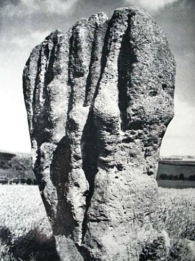
Duddo Stone (picture credit Garry Hogg)

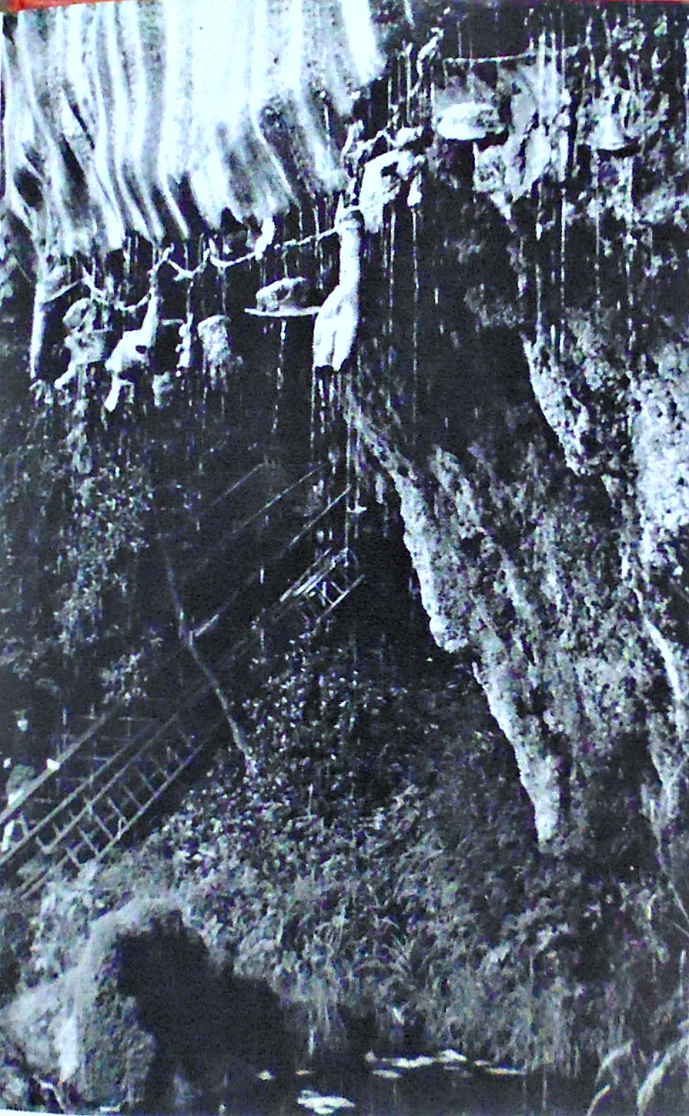
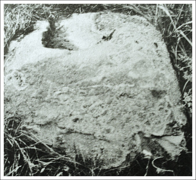
Over the centuries The Duddo Stones have aquired many strange names owing perhaps to the deep grooves that can be seen in all the stones – caused by 4,000 years of erosion due to rain and wind that often sweeps relentlessly across the hills and moors and, because the stones are made of sandstone rain running down the sides has made strange grooves or gulleys. The largest stone has been likened to “a clenched fist rising menacingly out of the rough turf,” according to Garry Hogg in his book Odd Aspects of England. One legend says that seven people working here on the Sabbath day were turned to stone as a warning to other locals. Other names include: ‘The Singing Stones’, ‘The Women’ and ‘The Seven Turnip Pickers’! The largest stone has possible cup-marks and there are said to be cup-markings on one or two of the other stones. Duddo Five Stones is said to be aligned with the Winter solstice. The circle is in the ownership of English Heritage.

Sources:-

Hogg, Garry., Odd Aspects of England, David & Charles, Newton Abbot, Devon, 1968.

Bord, Janet & Colin., Ancient Mysteries of Britain, p 208, Diamond Books (Harper Collins Publishers Ltd), 1991.

https://en.wikipedia.org/wiki/Duddo_Five_Stones

http://heritageaction.wordpress.com/2012/10/07/setting-of-duddo-stone-circle-saved-again-for-a-while/

Copyright © Ray Spencer, The Journal of Antiquities, 2013.


Rebecca’s Well, Wargrave, Berkshire

OS grid reference SU 7993 8048. One mile north of Wargrave village in woodland on the side of Crazies Hill and a few hundred metres north-east of Gibstroude farm, stands a Victorian wellhouse covering a more ancient spring now called Rebecca’s Well, but before that time it had always been called Rebra’s Well. The curious name ‘Crazies Hill’ is locally said to mean Cray-wy-seath Hill or ‘the hill of the fresh clean water of the waterless place’, which obviously refers to the old well there. Rebra’s Well is apparently ‘the healthy water place on the hill’, being pronounced in the local dialect form ‘Reb bar yagh wylle’, and “perhaps” being named for Rebecca (Rebekah) the prophetess from the Old Testament. The well is located in the woods just a little to the south of Crazies Hill Lane on the way to Cockpole Green. The town of Reading is 8 miles to the south-west.

The ancient well of Rebra had become, over the years, a muddy pool in the woodland at Crazies Hill, but it had been a source of water for the folk of Crazies Hill for some considerable time, indeed they had apparently frequented it for its health-giving, healing properties. In 1870 the local parson Reverend Greville Phillimore ordained that his flock “should not be revering the water alone,” so he decided to build a proper wellhouse and honour a Biblical personage in the form of Rebecca, believing the original name Rebra to be a shortened form of her name? The good reverend designed the interior well-basin himself, but he commissioned Gertrude Jekyll (1843-1932) the celebrated English garden designer to design the wellhouse, and what a delightful job she did too.

The folly-like building made of plastered-over brickwork is 10 foot high and has a conical tiled roof with gabled frontage; the design plan is a semi-circular one. There is a circular arch at the front with an inscription ‘REBECCA AND THE SERVANTS OF ABRAHAM AT THE WELL OF NAHOR’. The colourful painting on the front depicts Rebecca and a servant, or Isaac her husband, standing beside the well of Nahor. Inside the wellhouse there is a large round-shaped stone basin where the water now collects, sometimes though not always in a good quantity, and at the rear of this a carved stone with another inscription and a cross all in segmented panels. The well usually has an iron gate in front of the water basin that can be opened for access.

According to the O.T. (The Book of Genesis) the servants of the Prophet Abraham ran to meet Rebekah and said “let I pray thee drink a little water of thy pitcher” at the well of Nahor. The actual Biblical well was at a place called Haran or Horan just outside the city gates of Nahor in Mesopotamia, which is today the land between the rivers Tigris and Euphrates, including parts of Iraq, Iran, Syria and Turkey. Rebecca was the wife of the Patriarch Isaac and granddaughter of Nahor, brother of Abraham. She was the mother of Jacob and Esau and great-niece of Abraham. Legend says the died at Haran (Horan) and was buried in the Cave of the Patriarchs at Machpelah, near Memre. But Rebecca is remembered for her great hospitality to travellers (guests) traversing the hot Mesopotamian desert with their camels and, for providing water for them at the well of Nahor, which she always did with much humility, kindness and graciousness, thinking only for the well-being of her guests at all times.

Sources:-

http://www.imagesofengland.org.uk/Details/Default.aspx?id=395246&mode=adv

http://www.britishlistedbuildings.co.uk/en-395246-rebecca-s-well-wargrave

http://people.bath.ac.uk/liskmj/living-spring/sourcearchive/ns2/ns2mb1.htm


1 Comment

St Matthew’s Churchyard Cross, Rastrick, West Yorkshire

Rastrick churchyard cross of (Wikipedia).

The Rastrick church-yard cross, drawing by Joseph Horsfall Turner, 1893 (Wikipedia)

OS grid reference: SE 1383 2160. The cross-base stands near the entrance to St Matthew’s Church in the village of Rastrick, near Brighouse, West Yorkshire. It can be reached via the A643 Crowtrees Lane and Church Street at the south-western edge of the village. The church is an imposing building with a nice rotunda-like roof. The cross-base is located just inside the walled-churchyard enclosure, near the main entrance, and so can’t really be missed.

This three and a half foot-high (1.06 metres) cross-base is said to be Anglo-Saxon and probably dates from the 10th-11th century AD. It is all that now remains of a once proud Saxon high cross the shaft with its decorated cross-head would have stood inside the large, round socketed hole which measures 30cm by 25cm by about 15cm in depth. The rest of the cross has long since disappeared. The base-stone is of dressed gritstone which tapers away about three-quarters of the way up (75cm or 29′); the bottom of the base is square (52 cm or 20′).
.
There is a single line of roll-moulding running around the socket base and all four corners, one being edged with cable moulding. Some faint roll-moulding also runs around the top edge, just 5cm beneath the rim, which may also have faint traces of knotworking. Each of the faces of the base show more faint lines of roll-moulding from panels that have carved decoration. The south face has what is probably ‘The Tree of Life’ which comprises of scroll-like branches (interlacing) coming out in a sideways direction from the central stem. This type of decoration is repeated (but much eroded) on the west face, which was originally considered to be empty of any carvings. On the north face, the panel is divided by a straight-rib flanked by interlacing – this too is probably a representation of ‘The Tree of Life’.
.
It seems that the cross-base stands in it’s original position on or near to a Roman road that traversed the village – the cross would have no doubt marked what was originally an ecclesiastical boundary, or perhaps it was a graveyard marker for a Saxon cemetery. The cross-base is now a scheduled ancient monument listed as No 23376. It is also grade II listed.
.
References:-
 .
Register of Ancient Monuments Calderdale Council/environment/conservation and ancient monuments.
The Northern Antiquarian – Ancient Crosses.
Copyright © Ray Spencer, The Journal of Antiquities, 2013.
.


2 Comments

Malham Roman Camp, Low Stoney Bank, North Yorkshire

OS grid reference SD 9152 6542. On a high plateau of Malham Moor just above Low Stoney Bank, a few miles north of Malham and just east of the river Aire, are the large rectangular-shaped earthworks of Malham Roman Camp or Mastiles Roman Camp, dating from c71 AD. The earthworks cover 20 acres (96800 square yards). The camp was a temporary military camp built during the governorship of Quintus Petillius Cerialis (71-74 AD) in order to quell a rebellion by fearsome Brigantean warriors who inhabited that area and, whose leader had been Queen Cartamandua. She had earlier formed a rather ‘fragile’ alliance with the Romans in c52 AD – although this was only destined to last a short time.

The camp is quite well-defined and has an earthern bank 0.5 metres high and 5 metres wide with traces of an external ditch. There are four entrances, three of these at the north, east and south sides have an in-turned or curved inner bank, while the western entrance is damaged by a footpath and wall passing through the centre of the camp, left to right, which is known today by country walkers as Mastiles Lane.

English: Mastiles Lane Roman Marching Camp. Th...

Malham ‘Mastiles’ Roman Camp (Photo: John Illingworth – Geograph)

The camp was probably built by either the IX or XX legions who may have also had a hand in the building of the forts at Rey Cross beside the A66 at Stainmore Summit and, Stanwick, near Richmond. There are no traces of buildings inside the earthworks – it is presumed the soldiers lived in leather tents in the middle of the camp. Some 500 soldiers or more would have marched here at any one given time during the late 1st century AD, but the site was most likely abandoned when the tribal unrest subsided within a few years. We don’t know for sure whether the camp was ever re-occupied?

Sources:-

http://www.brigantesnation.com/SiteResearch/Roman/Malham/Malham.htm

http://www.outofoblivion.org.uk/record.asp?id=352


Trethevy Quoit, Tremar, Cornwall

Trethevy Quoit, Cornwall.

Trethevy Quoit,

OS grid reference SX 2593 6881. Some 2 miles to the west of the B3254 road between Liskeard and Launceston and 1 mile east of Tremar Coombe, on the edge of Bodmin Moor, stands the prehistoric burial chamber or portal tomb called Trethevy Quoit. The monument stands in a field along a short footpath at the west side of Tremar village, not far from Trethevy Cottage. The town of Liskeard is 5 miles to the south and the village of St Cleer is 2 miles to the south-west. Trethevy Quoit or ‘Dolmen’, to give it its other monument name, dates back at least 5,700 years. Locally, it is called ‘The Giant’s House.

Trethevy Quoit is still quite an impressive prehistoric monument standing at 9-10 feet high with its huge sloping capstone that looks as if it is poised to slide down to the ground at any moment! It is the largest and most impressive in Cornwall. The massive capstone is 12 feet long and is said to weigh 10 tonnes. It is supported by five upright stone slabs all roughly nine feet high and one other slab that does not connect with the capstone; originally, there were seven uprights. Near the top of the capstone there is a large round hole, but what this was for is uncertain, maybe for astronomical purposes or to catch the sun’s rays at certain times of the year (solstices), or perhaps it was made in more recent times?

Trethevy Cromlech in Cornwall.

There is also some uncertainty about the age of the monument; some historians say that it is from the middle to late Neolithic Age, around 3,700-3,500 BC (the middle Stone Age), while others think that it dates from the Bronze Age (about 1,800-1,200 BC). The back of the burial chamber has now fallen inwards, while at the front there is a large portal stone and a flanking stone that stands clear of the monument. But it seems that the funerary entrance was not at the front but at the side where there is a square-shaped opening at the bottom corner to enable bodies to be placed inside. Originally, a huge oval-shaped mound of earth would have ‘probably’ covered the stone chamber and was thought to have been over 6 metres in circumference – there is still a slight raised bank around the sides and evidence of the mound is still visible today. This was almost certainly the burial place of a chieftain or some high-ranking individual from a prehistoric tribe that inhabited the area thousands of years ago back in the mists of time.

About 1 mile to the north-west are ‘The Hurlers’, three early Bronze-Age stone circles.

Sources:-

Darvill, Timothy, Glovebox Guide – Ancient Britain, AA Publishing, Basingstoke, Hampshire, 1988.

Hogg, Garry, Odd Aspects of England, David & Charles, Newton Abbot, 1968.

Bord, Janet & Colin, Ancient Mysteries of Britain, Diamond Books (Harper Collins Publishers Ltd), 1994.

Copyright © Ray Spencer, The Journal of Antiquities, 2013.


2 Comments

St Illtyd’s Church, Llantwit Major, South Glamorgan, Wales.

English: St Illtud, Llantwit Major, Glamorgan,...

St Illtud’s, Llantwit Major, South Glamorgan (Photo credit: John Salmon Wikipedia)

OS grid reference SS 6990 9580. The Norman parish church of St Illtyd (Illtud) is located on Church Lane at the western-side of the town of Llantwit Major or, in Welsh, Llanilltud Fawr, in the Vale of Glamorgan. This large three-sectioned Norman church, one of the oldest in Wales, houses three very interesting Celtic stones with Latin inscriptions in memory of saints and kings that were associated with a monastic college founded here by St Illtyd at the beginning of the 6th century AD. There are also two medieval grave-slabs, one belonging to an ecclesiastic, some medieval wall paintings and two other ancient stones. At the far west-side of the church the Ragland Chantry Chapel stands in a ruined state. The town of Llantwit Major is 9 miles south-east of Bridgend and 15 miles south-west of the Welsh capital, Cardiff. Close-by the church are the earthworks of the Roman villa of Caermead, dating from the 1st century AD.

English: St Illtud, Llantwit Major, Glamorgan,...

Celtic crosses (Photo credit: John Salmon -Wikipedia)

Housed within the Galilee Chapel of the 13th-15th century church, the old western part that dates from c1100, are three very interesting antiquities: a Celtic cross and two memorial stones with carved decoration and Latin inscriptions. These date from between the 9th-10th centuries and originally stood outside in the churchyard. Cross no 1 ‘The Illtud Cross’ or Samson’s Cross stands at just over 6 feet high and dates from the 10th-century. Although only the base of the gritstone cross remains the decoration is very good, and there is interlacing and key-patternwork with inscriptions in the middle and at the top. The top inscription (front) reads: SAMSON POSUIT HANC CRUCEM PRO ANIMA EIUS or ‘Samson placed his cross for his soul’ and on the reverse side: ILTUTI SAMSON REGIS SAMUEL EBISAR or ‘for the soul of Illtud, Samson the King, Samuel and Ebisar’. Samuel was probably the carver of the cross.

Cross no 2 is ‘Houelt’s Cross’, a 6 foot high disc-headed or wheel-head cross from the 9th-century AD. This has fretwork and patternwork on its lower front section and Celtic-style knotwork, interlacing and key-patterning on the wheel-head, but on the base there is a Latin inscription recalling Houelt (Hywel) the son of Res – probably Rhys ap Arthfael, King of Glamorgan, who died in 850 AD. The inscription reads: ‘In the name of God the Father, and of the Son and of the Holy Ghost’. ‘This cross Houelt prepared for the soul of Res his father’. And no 3 ‘Samson’s Pillar Cross’ is 9 foot high and of the 10th-century. On both sides of this there is a long-winded inscription which reads: IN NOMINE DI SUMMI INCIPIT CRUX SALVATORIS QUAE PREPARAVIT SAMSON ABATI PRO ANIMA SUA ET PRO ANIMA IUTHAHELO REX ET ARTMALI ET TECANI and when translated ‘In the name of the most high (God) begins the cross of the (Saviour) which Samson the Abbot prepared for his soul, and for the soul of Iuthahelo (Judwal) the King and of Arthmael and of Tecan’. There is also a 7 foot-high carved cylindrical, pyramidal-shaped stone that may have originally been part of a pagan altar, and two smaller stones that are now worn and damaged but may once have been crosses bases.

St Illtyd or Illtud (450-530) may have been a native of Brittany, though some historians think he hailed from Breconshire. However, by about 460 he was living in south Wales and eventually, after a few years, entered in to the service of King Arthur as a knight and was, according to the legend, one of the keepers of the Holy Grail. At some stage he became a Christian and retired from the world to live as a hermit beside the River Hodnant in south Glamorgan. Here he met St Garmon, his uncle, and together they re-established a monastic school (Bangor Illtud Fawr) where an earlier monastery known as Cor Tewdws (College of Thedosius) had fallen in to decay. The date of the foundation of this monastery is uncertain but it’s beginnings were c480 AD and, certainly by 500 AD the monastic school was flourishing as a renowned centre of learning with many saints being trained there, including St David. A monastery continued to exist uptil the early 12th-century but then fell on hard times, but it was later reformed as a Benedictine house of Tewkesbury and lasted until after the dissolution of the monasteries in 1547.

As for St Illtyd he is thought to have died at Dol in Brittany about 530 AD. However, Welsh historians have always claimed that he died at his monastery in south Glamorgan, or maybe he died at Bedd-Gwyl-Illtyd near Libanus, Brecon, in southern Powys? We may never really know.

Sources:-

Allen, J. Romilly., Celtic Crosses Of Wales, Llanerch Publishing, Felinfach, Dyfed, 1989 (text originally published in Archaeologia Cambrensis 1899).

https://en.wikipedia.org/wiki/St_Illtyd%27s_Church,_Llantwit_Major

Spencer, Ray., A Guide to the Saints Of Wales and the West Country, Llanerch Enterprises, Felinfach, Lampeter, 1991.

Barber, Chris & Pykitt, David., Journey To Avalon, Blorenge Books, Abergavenny, Gwent, 1993.

Bord, Janet & Colin., Ancient Mysteries of Britain, Diamond Books, 1994.

Copyright © Ray Spencer, The Journal of Antiquities, 2013.


The Dropping Well, Knaresborough, North Yorkshire

OS grid reference SE 3475 5698. The famous petrifying well that turns anything to stone, eventually, is located within the Historic Theme Park known as ‘Mother Shipton’s Cave’, a visitor attraction just off the Harrogate road (A59) and on Long Walk, which runs alongside the gorge of the river Nidd, just half a mile south of the towncentre. At the side of the well is the equally famous Mother Shipton’s Cave, where the Yorkshire prophetess, fortune-teller and mystic lived for much of her life during the 16th century. The spa town of Harrogate is a few miles to the west.

The Dropping Well at Knaresborough, North Yorkshire.

The Dropping Well, Knaresborough, North Yorkshire.

The dropping well was undoubtedly known to our prehistoric ancestors, to the Romans, the Anglo-Saxons and also our medieval forefathers.  It was first recorded in 1538 and from that time onwards it has been visited for its rich mineral content and healing properties. But the place is geologically quite unusual in that the water that flows over the smooth limestone cliff and into a large rocky pool below is highly calcified, coming up from a deep pool or lake in the limestone above, so much so, that it leaves calcified deposits on anything that is placed beneath – indeed many curious objects have been left here over the centuries by thankful pilgrims; some quite notable visitors have left toys, hats, boots, stuffed birds and kitchen items belonging to them, but just about anything and everything is suspended below the overhanging cliff to collect the constant, fast-flowing drops of lime-rich water which eventually turns these items into stone – the very same thing that causes stalactites and stalagmites in deep underground cave systems. The well was visited in 1534 by English antiquarian John Leland (1506-52), who gave a very reasonable description of it for the time and was apparently very taken with the well.

Garry Hogg (1968) says of this petrifying well that: “Water flows over a limestone mass to fall into a natural pool below. A century and more ago a number of oddments such as hats, caps, shoes, gloves, were hung on a line beneath the dripping water. The lime in it has petrified—literally ‘turned to stone’—these objects. Visitors today leave oddments such as children’s toys, sock, scarves and so forth, to be naturally treated by the iron, lime, magnesia and sulphur; returning after some months, they see the early stages of a process that will be complete in perhaps a year or less.”

Close by the well, in the side of the hill, is Mother Shipton’s cave. Ursula Southill or Southell was born near the cave in 1486 or 1488? and died there in 1561. She lived in the cave as a sort of recluse and came to be known in later years as Mother Shipton the Yorkshire prophetess, fortune-teller, mystic and, to some a witch! This was probably because she always wore a pointed hat and had ugly, facial features, such as a crooked nose and a protruding chin. But Mother Shipton was not a witch in that sense.

Many local people, including the nobility and an abbot, came to seek her advice on medical problems and other issues that they were unable to resolve themselves. And Mother Shipton became famous for her prophecies with regard to many future events including: the plague, the civil war, the great fire of London, wheeled transportation, iron roadways (railways) and stone constructions carrying water such as viaducts. All these prophecies were to be published in pamphlet form for the first time in 1641 and reprinted in 1645 by William Lilly the prominent astrologist, and even Samuel Pepys mentions her in his diary wrote during the great fire of London in 1666, and in 1667 yet another pamphlet mentioned the Yorkshire prophetess, although these works were quite often embellished. Two of Mother Shipton’s prophetic verses fortell of the end of the world at some point in the future! And she foretold of royal marriages and deaths ie Henry VIII and Ann Boleyn, and of Mary, Queen of Scots, tragic execution.

Sources & References:-

Hogg, Garry, Odd Aspects of England, David & Charles, Newton Abbot, Devon, 1968.

Robinson-Walsh, Dawn (Edited), Stories & Tales Of Old Yorkshire, Printwise Publications, Tottington, Bury, 1993.

Woodhouse, Robert., North Yorkshire – Strange but True, Sutton Publishing Ltd., Stroud, Gloucestershire

Mother Shipton’s Cave – Wikipedia

Copyright © Ray Spencer, The Journal of Antiquities, Up-dated 2021.


Portfield Hillfort, Whalley, Lancashire

Portfield Hillfort, Whalley, Lancashire.

Portfield Hillfort, Whalley, Lancashire.

NGR: SD 7460 3553. About three-quarters of a mile east of Whalley in the Ribble Valley, Lancashire, beside Portfield Lane stands the prehistoric site known as Portfield Hillfort or Planes Wood Settlement, a promontory-type fort. Just half a mile to the west is the busy A680 Accrington Road and Spring Woods, with carparks and a number of woodland paths for the visitor to explore at leisure – all far removed from the Iron-Age hillfort-cum-settlement that lies just beyond. The hillfort with its man-made defensive ramparts can be found just behind Portfield farm and the splendid 14th-century tithe barn, a timber construction that was associated with Whalley Abbey. Close by is Leck beck and down in the valley at Whalley the river Calder winds its way southwards beneath Whalley Nab towards Great Harwood. In 1966 a hoard of Bronze-Age artefacts was dug up in the middle of the hillfort.

Portfield Hillfort (south-east rampart).

Portfield Hillfort (south-east rampart).

The fort covers an area of about three-and-a-half acres (roughly 152,460 square feet) and, although it is accepted that it dates from the Iron Age, there was almost certainly a much earlier settlement or enclosure on this site that was inhabited in the Mesolithic, Neolithic and Bronze-Age periods of prehistory, which would be 4,000 years BC or more. There were two main phases of construction in the case of the Iron-Age fort’s defensive ramparts, as is now known from the archaeological excavations that took place in the late 1950s.

The first phase sometime between 1,000-750 BC? was a stone rampart (with no ditch) about 13 feet across with stone kerbs on their sides at the back of the inside defence, while the second phase involved the levelling of the first rampart to construct bigger but ‘unusually’ low defensive bivallate ramparts, which were stone-revetted and up to 20 feet in width surrounding the enclosure area of the fort – being especially well-defined at the north-west side but, less so at the south-eastern and east sides. Beyond this there was a 20-foot wide berm and a ditch measuring 15-18 feet across. The excavations of 1958 and 1959 revealed a cobbled pavement at the main entrance to the fort, and over this another layer of stones. It was here that a fragment of Romano-British Roman pottery was discovered dating from the 5th century AD. A couple of the back gardens of the houses on Portfield lane have rather intruded onto what’s left of the eastern rampart, although this does not ‘in any way’ spoil the situation of the prehistoric site.

Portfield Hillfort (Eastern Rampart).

Portfield Hillfort (eastern rampart).

In 1966 while workmen were laying new pipes near the centre of the fort a hoard of Bronze-Age artefacts was uncovered – among the items found were two axes, a tanged knife and blade, a tanged stud, a gauge, part of a hilt, but much more of interest was the discovery of a gold penannular bracelet (possibly of Irish craftsmanship) and a gold tress-ring dating from the mid to late Bronze-Age. Then, in excavations during 1970-71, post holes were found as well as body sherds, flints and pottery sherds from a biconical vessel. There have also recently been a few finds dating back to the Mesolithic and the Neolithic ages, including flints and pottery. Many replicas of these artefacts can be viewed in the Blackburn Museum and also the Ribchester Roman Museum.

Joan Allen (1977) tells us that: “In September 1966, two Manchester Corporation workmen, digging a ditch in a meadow at Portfield Farm, Whalley, Lancs., located a gold armlet, gold hair-ornament (called a tress ring), a carpenter’s gauge and a number of bronze axe-heads and other tools. Museum experts believed that Bronze Age craftsmen had hoarded them underground between 700 and 800 B.C.”

Sources:-

Allen, Joan, Glittering Prospects—All You Need To Know About ‘Treasure Hunting’, Elm Tree Books Ltd., London, 1977.

Dixon, John & Dixon, Phillip., Journeys Through Brigantia (Vol 9) The Ribble Valley, Aussteiger Publications, Barnoldswick, 1993.

http://www.pastscape.org.uk/hob.aspx?hob_id=44511

http://www.webbaviation.co.uk/gallery/v/lancashire/whalley/PortfieldHillfort-fb34133.jpg.html

Copyright © Ray Spencer, The Journal of Antiquities, 2013 (updated 2024).


1 Comment

Ingleborough Hillfort, North Yorkshire

Ingleborough ascent

Ingleborough (Photo credit: Immanuel Giel – Wikipedia)

OS grid reference SD 740 745. The massive bulk of the Yorkshire peak Ingleborough mountain called ‘The Mountain of Fire’ is 2,372 feet high (a few maps call it a hill!). It is some 4 miles to the north-east of the town of Ingleton, and is best reached from the B6255 Ingleton to Hawes Road and then via the various footpaths running east up to the summit on which there is an Iron-Age hillfort and, also the remains of what may be a Roman encampment?  Down on the lower slopes of the mountain are the famous White Scar Caves and to the east lies the equally famous pot-hole of Gaping Ghyll.

.
Ingleborough’s flat summit is topped by a hillfort that dates back to the Iron-Age when the Brigantes tribe first settled there. The fort or settlement covers 15 acres (61,000 metres) and its defensive walls, now much robbed away, can still be seen around the edges of the windswept summit. These millstone grit ramparts cover 3,000 feet in circumference, some of which are made up of the natural rock edge which would have been quite helpful at the time as a defence. There are openings at the north, east and South-western sides of the ramparts. The inner part of the fort has 19 or perhaps 20 hut circles placed at intervals; the hut circles measure between 5 metres and 8 metres in circumference, though some historians call them ring structures without hearths and roofs, which were built by the Brigantes, a tribe that covered most of northern England from the west to east coast; they later supported the Roman invasion of the northern Pennines even though they were, at that time themselves under attack from the Roman legions who were spreading out and moving north, west and east. It seems likely that the Iron-Age hillfort was in general use all year round – the climate at that time being much more temperate than it is now, otherwise it would have been virtually impossible to live on the summit during the winter months.
.
Simon Fell, North Yorkshire, with Ingleborough...

Ingleborough (Photo credit: Mick Melvin -Wikipedia)

The Brigantean queen, Cartimandua, handed the Romans Caractacus, a British chieftain, who had led a guerrila-style revolt against the invading army in AD 51; Cartimandua then married Venutius, a Brigantean chieftain, but the marriage did not last long because in AD 52 they divorced and the queen married Vellocatus (who was then king from AD 52-69); he was Venutius’ own armour-bearer – causing him much displeasure. Civil war then broke out in the northern Pennines and to quell this disorder the Roman governor Quintus Petillius Cerealis (AD 71-74) ordered the IX legion to the area to put down the revolt. The Brigantes were crushed, while Venutius travelled north-east to Richmond where he was eventually defeated by elite Roman troops – it is not known what happened to him after that – more than likely he was killed at Stanwick near Richmond. The date of his death is not known.

.
On the northern and eastern edge of Ingleborough summit are the remains of some walling which some historians considered to have been a Roman military encampment – though there is still much uncertainty about this. The nearest Roman fort is at Bainbridge to the north which was connected by a Roman road from Ingleton to Lancaster via Cam Fell. Ingleton church is built on top of a mound that could have been used to protect the river crossing, but it is not thought to have been inhabited by the Romans and no evidence of any occupation by them exists in the town itself. Later the Anglo Saxons further to the west moved inland and settled in Ingleton and the surrounding settlements.
.
Sources:-
.
Bentley, John., – A Unique Yorkshire Village – The History of Ingleton, Ingleton Publications,2008.
Raistrick, Arthur., – The Pennine Dales, Arrow Books, 1972.
.
Johnson, David., – Ingleborough: Landscape and History, Carnegie Publishing Ltd., Lancaster, 2008
.
With thanks also to ‘The Northern Antiquarian’ (General Archaeology Section).
Copyright © Ray Spencer, The Journal of Antiquities, 2013.
.


1 Comment

Borrans Field Roman Fort, Ambleside, Cumbria

Roman fort of Galava

Roman fort of Galava (Photo credit: Ferrous Femur)

OS grid reference NY3724 0344. About ½ a mile to the south of Ambleside, south Cumbria, along Borrans Road which is the A5059 and close to the mouth of the river Brathay*, near the northern shoreline of Lake Windermere is Borrans Field Roman Fort or, the Roman name of Galava and, or perhaps Glanibanta, according to the Ordnance Surveys ‘Historical map and guide to Roman Britain’ 5th Edition, 2001. Although the former name is the one that is now generally accepted. Or could it be that the Roman fort at Ravenglass some 18 miles away to the west on the Cumbrian coast is the one called Glanibanta (Glannobanta), rather than the usual Roman name given to it: Itunocelum? Confusing, yes it is, but these Roman names for forts and towns are always “open” to question, are they not!

This small fort stands in the area known as Waterside, Eskdale. The earthworks and foundations of the fort can clearly be seen in what is locally called “Borrans Field’ where signboards mark out the fort’s features. There were two forts on the site – the first “Flavian” fort being built in the late 1st century AD at the time of the northern campaign of the Roman general Gnaeus Julius Agricola (79-85 AD) – the second one was built over this and probably staffed by an auxiliary cohort of soldiers in the early part of the 2nd century – that is if a piece of stone with an inscription to that effect found during excavations is to be believed.

The oblong-shaped enclosure of the fort covers about two-and-a-half acres roughly 300 feet by 420 feet though Prof R.G.Collingwood of Pembroke College, Oxford, who first excavated the site and wrote about it, gave the measurements as 270 feet by 395 feet. It was surrounded by a  stone wall 4 foot thick with a clay and turf rampart 10-12 feet across at the back of that and, a ditch to the front. Towers would have been positioned at each of the four corners with four gated entrances – three of these being fairly narrow though the fourth gate (the porta praetoria) at the east-side was double-gated and had guard rooms at either side.

Galava Roman Fort Plan (After Collingwood)

Galava Roman Fort Plan (After Collingwood)

All the main buildings were situated in the middle of the fort with four other large barrack block buildings, probably of timber, around the sides of these and, as yet, not excavated. As usual there were the granaries (two buildings) measuring 60 feet in length, three headquarters blocks known as ‘the principias’ or Praetoriums roughly all 70 feet by 80 feet; also a sacellum (cellar) for altars around 6 foot square, the commandant’s house 70 feet by 80 feet and two other unexcavated buildings. Also, inner and outer courtyards as well as a ditch which could be from the late 1st century fort. According to Prof Collingwood, the fort was abandoned sometime after 85 AD but rebuilt and enlarged during the time of the Emperor Hadrian in the early 2nd century AD. Collingwood believed it was destroyed twice during the 2nd-3rd centuries. The fort of Galava was finally abandoned soon after 365 AD. Today the site is in the care of English Heritage.

Galava Roman fort stands on the course of a Roman road which runs west from here linking up with the forts at Hardknott (Mediobogdum) and Ravenglass (Itunocelum) also known as Glannobanta or Clanoventa? At Ravenglass there is a well-preserved Roman bath-house attached to the fort called ‘White Walls’ standing to it’s original height and, is probably the best preserved Roman building in the north of England. The Roman forts at Watercrook (Alavana) and Brougham (Brocavum) to the east and south-east are “somewhat” in doubt with regard to being linked strategically with the fort of Galava, although this is still open to question.

There have been a number of archaeological finds and these can be seen in the Kendal Museum. A tombstone found in the 1960s at the eastern-side of the fort is inscribed with the epitaphs of two Roman soldiers: Flavius Romanus and Flavius Fuscinus, who may have been related; also a piece of stone inscribed with the word COHORT, and some coins from the late 1st century to the 2nd century. Pottery, glass, iron and bronze objects, as well as a lead basin were also found.

Sources:-

Collingwood, R.G. Prof., Roman Eskdale, Methuen, London, 1914.

Collingwood, R.G. Prof., The Archaeology Of Roman Britain, Methuen, London, 1930.

Fraser, Maxwell., Companion Into Lakeland, Methuen, London, 1939.

Ordnance Survery, ‘Historical map and guide Roman Britain’, 5th Edition, Southampton, 2001.

*Thanks to Mike Nield for his info on the location of the fort at Borrans Field.

http://en.wikipedia.org/wiki/Galava

http://www.roman-britain.org/places/galava.htm


The Nogworth and Beth Crosses, Briercliffe, Lancashire

The Nogworth Cross-base, Briercliffe, Lancs

The Nogworth Cross-base, Briercliffe, Lancashire.

OS grid reference SD 8833 3408. The Nogworth Cross also called ‘The Northwood Cross’ is located to the north of Extwistle between Extwistle Hall and Monk Hall about 2 miles south-east of Briercliffe. What remains of the cross stands at the side of a country lane close to Shay Lane and Todmorden Road – having been moved here in 1909. Today only the roughly-hewn base remains, which is a slightly tapered block of sandstone about 3 feet 3 inches across and 20 inches high with a socketed recess at the top for the stump or shaft of a medieval cross – the shaft and cross-head having long since disappeared. The thinking being that this was a former market cross from the 14th-15th century? Or could it have been set-up by the monks of Whalley Abbey to mark the boundary of the land that they owned from the 13th-16th centuries? The Cistercian abbey at Whalley was founded in 1172 and dissolved in 1537. Many people walking along the country lane at Extwistle would now not even notice the lump of stone lying forgotten in the grass beside the wall, which is quite sad really.

Beth Cross or perhaps ‘The Roggerham Cross’ remains largerly forgotten and lost to the mists of time. It was a flat piece of stone with a very faint incised Latin-style cross carved onto it. It’s location is not known, but it was said to have lain in the Holden Clough area about half a mile to the south-east of the Nogworth Cross. It was thought to mark the extent of the land, or the boundary, of the land owned by the small abbey of Newbo near Sedgebrook in Lincolnshire, which was a Premonstratensian foundation founded in 1198 but abandoned soon after 1401. But why did they hold land at Roggerham so far away from their religious house in Lincolnshire. This is something of a mystery. And to confuse things even more there was a ‘Dennis Cross’ and also a ‘Widdop Cross’ (site of) in the same area. Roggerham itself is a tiny hamlet along Todmorden road, Extwistle, to the east of Lee Green reservoir and is not even mentioned on the Os maps. The name ‘Beth Cross’ is a shortened form of Elizabeth’s Cross (maybe some association with St Elizabeth?).

English: Nogworth Cross Shay Lane Base and soc...

Nogworth Cross (Photo credit: Kevin Rushton – Wikimedia Commons)

These wayside crosses were all surveyed by Mr Clifford Byrne in the late 1960s though his work was never published – he also did a survey of Holy Wells and Mineral Springs of North-East Lancashire. [Any further information on the Beth Cross or The Roggerham Cross would be very much appreciated].


Sources:-

The Briercliffe Society (Newsletter archive number 92 May 2007).

Byrne, Clifford., A Survey of the Ancient Wayside Crosses of North-East Lancashire, unpublished manuscript, 1974.

http://www.britishlistedbuildings.co.uk/en-184021-nogworth-cross-at-sd-883-340-briercliffe


Masham Churchyard Cross, Wensleydale, North Yorkshire

English: Anglo Saxon shaft at Masham church. T...

Masham Churchyard Cross (Photo credit:  Gordon Hatton for Wikipedia)

OS grid reference SE 2266 8066. In the Valley of the River Ure, Wensleydale, 8 miles to the north-west of Ripon and some 4 miles west of the A1 in north Yorkshire stands the picturesque market village of Masham on the A6108 and, close to the market square is the ancient church of St. Mary the Virgin. Just by the south porch there is a quite rare Anglo-Saxon cross-shaft Masham Churchyard Cross which originally had some of the best carvings in the Dales, but sadly these ancient carvings are now rather weather worn. St. Mary’s church also houses two pieces of a Saxon cross.

In front of the porch stands a 7 foot (2.1 metre) high rounded cross-shaft, or pillar cross, said to date back to the 8th or 9th century AD, and probably of Northumbrian craftsmanship. It stands upon a modern stepped base that, sadly, does not do the ancient cross any justice. The top is now protected by a lead cap. Despite being heavily weather-worn the richly carved shaft is quite splendid with much beautiful carving. The cross-head has long since gone. This is a four-sectioned shaft with carvings inside round-headed arcades. Just below the top damaged section Our Lord and the Apostles are depicted, while below that are what appear to be human figures awaiting baptism, or being baptised, and also the Adoration of the Magi. But the carvings are badly worn and are now difficult to make out.

It could be that the cross was set-up as a dedication to St Wilfrid, who was bishop of Ripon from 667-669, by his many followers who were converting large swathes of northern England to Christinanity at this particular time – the cross then being the central focus as a meeting place for local Christians to hear the word of God.

St. Mary’s Church, Masham, dates from the 12th-15th century (Norman and medieval). The tower dates from 1150, but an earlier Saxon foundation of the early 7th century from the reign of King Edwin of Deira and Bernicia (Northumbria) 616-633 stood near this site. King Edwin was baptised into the Christian faith in 627 and after his death in battle at Hatfield Chase he was venerated as a saint. There are still traces of Anglo-Saxon masonry in the fabric of the nave wall. Also in the church two pieces of a 9th century Anglian cross – notably part of the cross-head (looks like a small section of an arm) and a piece of the cross-shaft.

Sources:-

Carter, Robert A.,  A visitor’s guide to Yorkshire Churches, Watmoughs Limited, Idle, Bradford, West Yorks, 1976.

https://commons.wikimedia.org/wiki/Category:St_Mary_the_Virgin_church,_Masham

Click on the link for more information on King Edwin of Northumbria   http://en.wikipedia.org/wiki/Edwin_of_Northumbria

Copyright © Ray Spencer, 2013.


The Burnley, Colne And Nelson Upland Archaeology Project

A new web-based archaeological project has been started by the Barrowford author and archaeologist John A.Clayton to map with ‘LIDAR’ Technology the east Lancashire towns of Burnley, Nelson and Colne – taking in the surrounding upland areas of Thursden, Extwistle, Worsthorne and Mereclough – with a view to uncovering the ancient past of these places and, to map their prehistoric past from the many Mesolithic camps, Bronze Age barrows, Roman enclosures to Medieval water-mills with LIDAR mapping. Please take a look at this new and very exciting website by clicking on the following link  http://www.barrowford.org/pendle-archaeology.html

Hi – the new books relating to the BNC Archaeology Survey are now in print. They can be purchased online at www.barrowfordpress.co.uk  or by cheque directly from me. They are also available at The Pendle Heritage Centre, Barrowford.

Best,

John Clayton

Barrowford.


The Map Stone, Fylingdales Moor, North Yorkshire

The Map Stone (Copyright English Heritage)

The Map Stone (Copyright English Heritage)

OS grid reference approx NZ 935 010. In the late summer of 2003 during the the devastating fires that destroyed up to two-and-a-half kilometers of Fylingdales Moor to the south-west of Ravesnscar, north Yorkshire Moors, a round-shaped flat piece of stone was uncovered by archaeologists from English Heritage bearing strange shapes and lines. This stone has been referred to as The Map Stone or The Fire Stone for obvious reasons. Today a cast of this curious stone can be seen in Whitby Museum. The actual site of the find is ‘protected’ and now covered over again with heather and grass, but it is ‘roughly’ just north of the A171 near Flask Inn which is 6 miles north-west of Ravenscar. [Please keep to the designated footpaths across the moor]. At the time of the moorland excavations many other artefacts were uncovered including a smaller stone that has tiny hollows or cup-marks carved onto it.

The carved stone with its strange map-like patterns, zig-zags or chevrons and linear lines is now considered to date back to the Neolithic period some 4,000-5,000 years ago, according to English Heritage archaeologists, though some historians place it in the Bronze-Age? It was found underneath the burnt heather and turf set within a low ring of boulders forming a cairn, and next to it was a smaller piece of stone with cup-marks. The thinking at the time was that the stone, which was originally larger, was a sort of map of the area showing tribal settlements, mountains and other features, but it is now thought by archaeologists to be a funery grave-cover with depictions of the after-life. The stones were recorded and photographed in situ and then the turf and heather re-laid to protect the artefacts from further erosion. In all some 2,400 artefacts and other sites were found exposed in the area of devastation (up from a previously-known 150) – ranging from Mesolithic flints, 185 carved stones, ancient trackways, watercourses from the local alum industry, to slit trenches from World War II.

Sources:-

Fletcher, Terry., Dalesman, February 2005 Volume 66 No 11, Dalesman Publishing, Skipton, North Yorkshire.

Click on the link  http://www.stonepages.com/news/archives/002382.html


2 Comments

Brimham Rocks, Summerbridge, North Yorkshire

Brimham Rocks, near Summerbridge, North Yorkshire.

Os grid reference SE 2085 6458. About 2 miles to the north of Summerbridge in Nidderdale, north Yorkshire, is Brimham Moor on which can be found the millstone grit outcrops known as Brimham Rocks, with many weird and grotesque-shaped rocks that have been eroded by the elements over many thousands of years. The rock outcrops here cover between 50-60 acres of the moorland. These weathered rocks, boulders and tors have, probably since the Victorian Age, been given strange names – many looking like animals – others like the devil, druids and even Mother Shipton. A carpark is provided for visitors near to Brimham House (now The National Trust visitors Centre) with numerous paths weaving in and out around the rocks, which are surrounded and partly hidden by birch trees, bracken and heather. The site is now owned by The National Trust Estate. Brimham Rocks are 3 miles to the east of Pateley Bridge on the B6265 road.

The millstone grit outcrops on Brimham Moor were first laid down in geological terms some 400 million years ago, but the erosion and weathering only actually began in somewhat more recent times – to be precise some 18,000 years ago during one of the Ice-Ages. Glaciation and sedimentation first played its part, then the elements like rain wind and frosts began to slowly weather the rocks into the strange grotesque shapes that we see today, and this has been going on since that time. The huge rocks have gradually formed themselves into pinnacles, buttreses, tors and crags – some of them being 50 feet high and weighing up to 200 tonnes.

English: Idol Rock - Brimham Rocks

Idol Rock – Brimham Rocks (Photo credit: Penny Mayes – Wikipedia)

Here we can see some of the most odd-shaped rock formations in the north of England. The most famous being the 15 foot high Idol Rock, also called ‘The Druids Idol’ or ‘The Druid’s Writing Desk’ which sits or pivots on a lump of rock only 1 foot in circumference, looking like it could fall over at any moment! But it dosen’t. The Turtle Rock or ‘Eagle Rock’ is also quite a distinctive shape as are The Leaning Tower Rock and Elephant Rock, but so too are the so-called ‘Sphinx Rock’ (Dancing Bear), ‘Crown Rock and Kissing Chair’, ‘The Knob’ and ‘Anvil Rock’. There are also rock formations that resemble the devil and Mother Shipton, a 17th century prophetess who lived in a cave beside the river Nidd at Knaresborough. So did she ever visit Brimham Rocks? And one of the rocking stones apparently has some prehistoric cup-marks near its base, which would suggest that Neolithic tribes inhabited the area and probably recognised it has being a sacred place.

Rock climbers used to be able to climb the rocks and tors but I don’t know whether they are still allowed to do that today? But people do still attempt to stand or sit on top of some of the more accessible outcrops and rocks in order to get a good view of Nidderdale and the surrounding areas.

Sources:-

https://en.wikipedia.org/wiki/Brimham_Rocks

Hammond, Reginald J. W., Ward Lock’s Red Guide — The Yorkshire Dales, Ward Lock & Co. London, 1965.

Poucher, W.A., The Peaks & Pennines, Constable, London, 1973.

Rawson, Jerry., Hidden Gems – Dalesman (Vol 66 No.11), Dalesman Publishing, Skipton, North Yorkshire, 2005.

Copyright © Ray Spencer, The Journal of Antiquities, 2013 (up-dated 2022).