The Journal Of Antiquities

Ancient Sites In Great Britain & Southern Ireland


2 Comments

Samson’s Toe, Langcliffe, North Yorkshire.

Samson's Toe Glacial Erratic Boulder, Langcliffe, North Yorks.

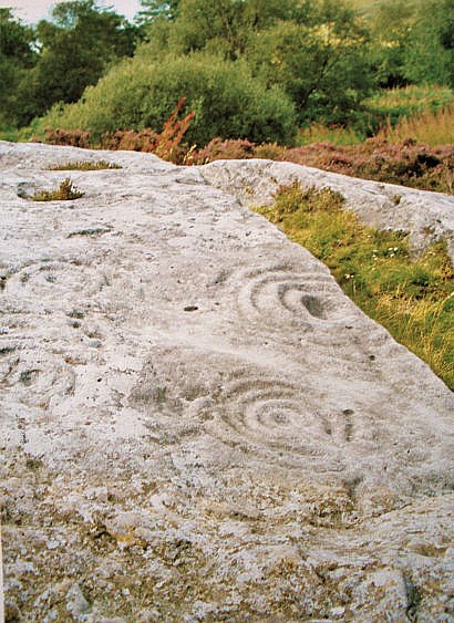
Samson’s Toe Glacial Erratic Boulder, Langcliffe, North Yorks.

Os grid reference SD 83176 66229. About 1 mile to the east of Langcliffe village, near Langcliffe High Mill, in the Yorkshire Dales National Park, stands a huge glacial erratic boulder that is locally called Samson’s Toe. It is located in an area of limestone ridges and scars known as ‘Whinskill’, which is probably a Scandinavian name. Here, in this barren, rocky land, there are a number of large boulders known as “rocking stones”. To the north the great bulk of Pen-y-Ghent can be seen as can the flat-topped Ingleborough further to the north-west – when the weather is fine and sunny that is! The town of Settle is 2 miles to the southwest.

The great boulder can be found in a limestone-strewn area called ‘Whinskill Rocks’, just west of Henside Lane and close by a wooded area. Lower Whinskill Farm can be seen a bit further to the west. The glacial boulder called Samson’s Toe is approx 8 foot high and it stands (or pivots) upon little limestone stilts that, because they have been protected have not eroded away, at the edge of a ridge of limestone. It is said to be possible to “rock the stone” but you would need many strong men to do this! The boulder has, however, suffered from graffiti some of which could date from the Victorian age.

The boulder is apparently shaped like a giant’s toe – the giant in question being Samson. According to legend, he lost his footing when jumping across from Langcliffe Scar or Ribblesdale, breaking off his toe whilst attempting this. But, in fact, the boulder was deposited here at the last Ice-Age 12,000-13,000 years ago or more by retreating glacial flows moving from north to south – the boulder being picked up by the glacier somewhere to the north, perhaps the Lake District, or a bit closer to home. The great boulder is made from something called “greywacke”, a grey-black hard sandstone made up of fine pebbles, quartz, feldspar and other rock fragments. There are two other boulders nearby, just to the east over on the opposite side of Henside Lane, which make up the Whinskill Rocks –  these are also referred to as “rocking stones” on ordnance survery maps of this area.

Sources:-

Thanks to David Gledhill for the up-dated grid reference.

Cook, David & Kirk, Wendy., Pocket Guide Rocks & Minerals, Larousse, London, 1995.

Click on the following link  http://flickrhivemind.net/Tags/winskillstones/Interesting


4 Comments

Roughting Linn, Bar Moor, Ford, Northumberland

Roughting Linn Cup-Marked Rocks, Northumberland (photo credit: Ronald Sheridan).

Roughting Linn Cup-Marked Rocks, Northumberland (photo credit: Ronald Sheridan).

OS grid Reference TN 9839 3672. About 2 miles east of the village of Ford is the prehistoric, sacred site of Roughting Linn or Rowtin Linn, on Bar Moor, where there are many cup-and-ring markings or petroglyphs on a long, sloping slab of fell sandstone beside a quarry that was in use pre 1950. The site can reached to the north of the B6525, beside a lane between Milfield and Lowton near Roughting Linn farm. Walk a short distance into Linn woods where there is a waterfall on the Broomridgean Burn and also an Iron-Age hillfort (the rock carvings lay at the east-side of the hillfort). The coastal town of Berwick-on-Tweed lies 12 miles to the north-east and the town of Coldstream is 13 miles to the west.

The long, domed-shaped slab of light grey sandstone forming the rocky outcrop with some very impressive rock-art is approx 20 metres in length and, thankfully the rock carvings have not been much disturbed by the adjacent quarrying. These prehistoric carvings are “thought” to date back over 4,000 years to the Neolithic to Early Bronze-Age periods. Luckily recent quarrywork activity has not caused too much damage to the cup-and-ring marked rock, apart from the western section, and the site remains the best known in the county of Northumberland and is the largest carved rock in northern England. There are “said” to be 160  or so rock carvings ranging from ordinary single cups, cups-and-rings with well-defined grooves, linked grooves, radiating lines, inverted arcs, maze-like carvings and keyhole-type motifs all spread out across this huge, long slab of fell sandstone that at first sight has the look of limestone – but it is not!

Counting the carvings is difficult, but there are apparently 60 or more lesser-known ones (ordinary cup-marks) and 100 or so carvings that are much more interesting and more stunning to the eye. Many of the cup-and-rings are similar to rosette patterns with a small hollow in the middle and concentric rings running around that, and other carvings that are often seen on mazes. We don’t know what the radiating lines were for but maybe they were a way of connecting up each carving, or as a pointer system for directional usage, like the solar system with stars in alignment, which the ancient people would have known about at the time. The place was probably associated with spirituality, birth, death, magic and ritual. And there was undoubtedly a prehistoric community of beaker people living here that saw the rock and its growing number of carvings as very sacred.

The site was first discovered back in 1852 by Canon William Greenwell who wrote about the carvings in two pamphlets for the Archaeological Institute at Newcastle, but unfortunately these were never published. Then later in 1865 Mr George Tate did the first drawings of the site. There are two more cup-and-ring marked rocks about 1 mile to the west just below Goatscrag Hill.

Just beside the rock carvings stands an Iron-Age promontory fort with some very impressive ramparts at the south-eastern side, and there are the ditches of an ancient enclosure between the fort and the rock outcrop. But what connection this fort has to the rock-art we do not know. Maybe the Neolithic beaker community and, later Bronze-Age settlement were taken over by Iron-Age people who strengthened and built-up the place for their own security, but they too would have been well aware of the sacredness of the place, just as we are today!

Sources:-

Bord, Janet & Colin., Ancient Mysteries of Britain, Diamond Books, 1991.

Greenwell, William Revd., On the rock carvings at Roughtin Linn (un-published pamphlets 2 vols), The Archaeological Institute of Newcastle, 1852.

Click on the following link: https://commons.wikimedia.org/wiki/File:The_cup_and_ring-marked_outcrop_at_Roughting_Linn_-_geograph.org.uk_-_1282481.jpg

Newbery, Elizabeth & Fecher, Sarah., Ford And Etal – A companion guide, Ford and Etal Estate, Ford, Berwick-on-Tweed, 1995.

Click on the following link  http://www.bradshawfoundation.com/british_isles_prehistory_archive/northumbria_rock_art/roughting_linn.php

Copyright © Ray Spencer, The Journal of Antiquities, 2013.


2 Comments

Ilam Churchyard Crosses, Staffordshire

Ilam Churchyard Cross, Staffordshire

Ilam Churchyard Cross, Staffordshire

OS grid reference: SK 1325 5069. The very pretty little village of Ilam in north-east Staffordshire stands beside the River Manifold, 4 miles north-west of Ashbourne and 2 miles north of the A52. It is situated just a few miles from the border with Derbyshire. Beside Ilam Hall, an early 19th century Gothic building, stands Holy Cross church, originally a Saxon foundation, and in the churchyard near the porch and at either side of a more modern churchyard cross, are two Anglo-Saxon preaching crosses; one being a typical Mercian-style cross, although both are now without their cross-heads. In the church, there is the medieval shrine and tomb of the local hermit saint, Bertelin, and close by are two holy wells associated with the saint, which were credited with miraculous healing powers.

The smaller of the two crosses is described as traditionally Mercian in style. It stands at 4 feet 3 inches high and is a cyllindrically-shaped pillar with very little of its round cross-head surviving, having suffered from vandalism, although a small boss can still be seen. A raised collar runs around the middle with some raised links running downwards forming a square. The rest is now well-worn and difficult to identify. When it was examined just below ground in 1890 by Rev G.F.Browne it was found to be standing in a rude-stone socket. The second cross over 5 foot high is the more normal Anglo-Saxon thin pillar-shaped cross that has been restored in two places – again due to vandalism. The cross-head has long since gone. However, this cross still displays some interesting carvings, including a scroll or circle, knotwork interlacing and at the bottom what could be the top part of a human figure is portrayed in a rounded panel. Both crosses date from between the 8th and 11th centuries AD.

A third rather battered cross shaft stands on Paradise Walk beside the River Manifold in Hinkley Woods half a mile to the south-west of the church. This one was rescued in 1840 from the foundations of a cottage close by and was said to have originally marked the site of a battle between the Saxons and Danes. It is referred to as ‘The Battle Stone’. The well-worn carvings are similar to those on the two Ilam churchyard crosses, and of a similar date.

Ilam Churchyard Crosses, Staffordshire.

Ilam Churchyard Crosses, Staffordshire.

In Holy Cross church is the medieval shrine tomb of the local Saxon saint, Bertram, Bertelin or Bettelin, an 8th century prince of Mercia who lived here as a hermit. According to the Legend, St. Bertram visited Ireland where he married an Irish princess, but soon returned to his father’s kingdom of Stafford (his father may have been King Ethelbald?) along with his pregnant wife, but on the way both his wife and newborn baby son were killed by wolves. Later, he became a Christian and studied under St. Guthlac at Crowland, Lincolnshire, but as a penance for what had happened to his family, he decided to withdraw from the world and became a hermit beside a well (St. Bertram’s Well) at Ilam. The well is still there today beneath an ash tree, locally called St. Bertram’s Ash, which can be found on Bunster Hill near Townend farm to the north of the village. This healing well is located on a strong ley-line that links the prehistoric sites of Foolow and Arbor Low in Derbyshire, a distance of over 16 miles.

But there is another well associated with the saint just a little south of the church beside Paradise Walk. This is a rectangular walled construction with a holy water basin (baptismal pool) in the middle. St. Bertram supposedly died here at Ilam in the early 8th century AD and his tomb and medieval shrine were built over his resting place within Holy Cross church to which pilgrims came, and still do, in the hope of a miraculous cure. However, some historians are of the opinion, whether right or wrong, that the saint died at Stafford, of which he is now the patron saint, with his feast day on the 10th of August.

Sources:-

Sharpe, Neville T., Crosses Of The Peak District, Landmark Publishing Ltd., Ashbourne, Derbyshire, 2002.

Pickford, Doug., Staffordshire – Its Magic & Mystery, Sigma Press, Wilmslow, Cheshire, 1994.

Browne, G.F. Rev., On The Pre-Norman Sculptured Stones Of Derbyshire, [thesis], 1890.

Copyright © Ray Spencer, The Journal of Antiquities, 2013 (updated 2025).


Bewcastle Cross, Bewcastle, Cumbria

English: The 7th C Bewcastle Cross (3), near t...

Bewcastle Cross (Photo credit:  Mike Quinn. (Wikimedia Commons)

OS Grid Reference: NY 5651 7466. Located at the west side of the remote Cumbrian hamlet of Bewcastle, beside the ruined Norman castle, and in the churchyard of St Cuthbert’s stands the famous and highly sculptured Anglo-Saxon Bewcastle Cross. The village is just a few miles to the north of Hadrian’s Wall and close to the border with Northumberland. The city of Carlisle is 14 miles to the southwest beside the M6 motorway, while the village of Brampton is 9 miles to the south. Also at the western side of Bewcastle are the hexagonal-shaped earthworks of Forum Cocidii (Cocidium), a fairly large early 2nd century Roman fort. The church of St Cuthbert stands inside the fort. A Roman road (Maiden Way) runs southeast from here to the Roman wall and another fort at Birdoswald (Banna).

The cross-shaft is made from a single section of sandstone but is now without its cross-head but, even so, it stands to a  height of 4.5 metres (14 feet 6 inches) and is said to date back to the 7th or 8th century AD. All four sides of the shaft are beautifully and intricately carved in relief with human figures, animals, knotwork, interlacing, scrolls and runic inscriptions (one of which recalls a 7th century Saxon king) which were probably carved by stonemasons from the Saxon monastery of Monkwearmouth in Northumbria. They were asigned to carve the cross by St. Benedict Biscop, abbot of Wearmouth in 670 AD, and may well have come from overseas; and were possibly the same stonemasons who carved the Ruthwell Cross, Dumfrieshire, in the south of Scotland, but which was formerly a part of Northumbria?

English: The 7th C Bewcastle Cross - St. John ...

Bewcastle Cross – St. John? (Photo credit: Mike Quinn. (Wikimedia)

The cross-shaft is richly sculptured with Biblical and other religious and also non-religious decoration on all its four sides. These relief carvings are set inside panels of varying sizes; the west face is considered the best because it has three carvings of Biblical characters. At the top in a panel is St. John the Baptist with a lamb (Agnus Dei), below which a short runic inscription: GESSUS KRISTTUS ‘Jesus Christ’. The middle panel has Christ in magesty holding a scroll while treading upon two beasts. The bottom carving is possibly that of St. John the Evangelist with his trademark eagle or hawk perched on his wrist. The north face has a rather worn runic inscription at the top, below which there are vine scrolls, knotwork and interlacing, while the bottom has an inscription to Kyniburg (Cyniburga), wife of King Aldfrith of Northumbria?

It is thought the runic inscription, now incomplete, on the top of the north face should be interpreted as:- THISSIC BEACN THUN SETTON HWAETRED WAETHGAR ALWFWOLTHU EAC OSWIUG CEBID HEO SINNA SAWHULA which roughly translated is ‘This slender pillar (cross) of Hwaetred, Waethgar and Alwfwold set (it) up in memory of Alefrid, a king and son of Oswy’. ‘Pray for them, their sins and their souls’. The east face (top to bottom) has interlinking vine-scrolls in one complete panel, while the south face is carved with three more panels of interlacing, knotwork, scrolls, chequers and a cross; this face also has a very rare sundial. King Alcfrith ruled Northumbria (which included Cumbria, the northern Pennines and Scottish borders) between 685-704 AD, and was said to have been a scholarly ruler, a patron of the arts, and generous to the monastic church during the late 7th century.

Sources:-

Board, Janet & Colin., Ancient Mysteries Of Britain, Diamond Books, 1994.

https://en.wikipedia.org/wiki/Bewcastle_Cross

Kerr, Nigel & Mary., A Guide to Anglo-Saxon Sites, Paladin, London, 1982.

Maughan, John Reverend., The Bewcastle Cross Inscriptions, Manuscript in Durham University Library.

More information and photos by Mike Quinn here:  https://en.wikipedia.org/wiki/Bewcastle_Cross

Also take a look here:  http://www.bewcastle.com/bewcastle-cross/

Copyright © Ray Spencer, The Journal of Antiquities, 2012, and up-dated 2020.


The Shrine Of Rocamadour, Perigueux, Midi-Pyrenees, France

English: Rocamadour Deutsch: Rocamadour

Cave of St Amadour at Rocamadour, France (Photo credit: Wikipedia)

Latitude 44.799682. Longitude 1.617066. Located at over 1,600 feet up in the foothills of the Pyrenees, Causse de Gramat, Dordogne, in south-west France is The Shrine of Rocamadour, a place of pilgrimage since medieval times, if not before that. Roc means ‘Cliffe’ and Amadour (meaning ‘pure’) is the name of a Biblical saint of the 1st century AD who is otherwise known as Zacchaeus. In the steep-sided gorge above the river Alzou (on the right bank) stands ‘The Sanctuary of The Blessed Virgin Mary’ with a 12th century cave-church dedicated to St. Amadour and, on the hilltop above stands the pilgrimage church of Notre Dame, which houses the famous and much venerated cult figure of the ‘Black Madonna’ and another church of St. Sauveur that has numerous paintings and inscriptions recalling pilgrimages over the centuries. The town of Perigueux is 12 miles to the north-west and Cahors is 10 miles to the south on the E9 highway.

According to tradition and legend, Amadour or Zacchaeus was a native of Galilee or Jericho in the Holy Land and some scholars think he was the husband of St. Veronica. It was St. Veronica who wiped Christ’s face in a cloth when he was being taken to his crucifixion on Golgotha. Earlier, Zacchaeus had climbed a sycamore tree in Jericho in order to see and hear Christ preaching. After the crucifixion he accompanied other members of Christ’s family, including the three Marys, and other close relations to Gaul bringing with him a sacred wooden image of the Blessed Virgin Mary made from wallnut that was, perhaps, carved by St. Luke the Apostle, or maybe by Zacchaeus (Amadour) himself? Though it is claimed by some authorities that the image dates from the 8th or 9th century AD. He also brought with him some drops of the Virgin Mary’s breast milk.

The Black Madonna, Rocamadour, France.

The Black Madonna, Rocamadour, France.

Amadour lived the life of a hermit in a cave at Rocamadour and placed the wooden image in there. Today the cave in the Alzou gorge houses a church that is dedicated to the hermit saint and contains his relics which were placed here by Benedictine monks in 1166, after they had found his body to be still incorrupt. St. Amadour’s feast-day was placed on the 1st May, and he or another saint called Amadour is venerated at Lucca in Italy where is kept the so-called ‘Holy Face’ – the famous cloth belonging to St. Veronica. Amadour according to legend, visited Rome at the time of St Peter’s martyrdom there and also, perhaps, Constantinople. He died about 70 AD. Today the wooden image of the Black Madonna with the Christ child seated on her knee is safely housed in The Chapelle Miraculeuse inside The Church of Notre Dame on the hilltop above the cave-church, which has been a place of veneration and pilgrimage since the middle-ages and remains so today. There is also a chapel dedicated to St. Michael the Archangel and what is said to be a miraculous bell.

Also in the this Pyrenean town near the Church of Notre Dame is the 11th-13th century Basilica of St. Sauveur (Saviour), another place of pilgrimage down the centuries and, to which many kings, princes, saints and noblemen have payed homage. St. Bernard and St. Dominic are said to have come on pilgrimage here, as did Emperor Charlemagne. Many of these rich pilgrims have left inscriptions upon the walls and arranged for wall paintings to be initiated as a sign of their benevolence to the Blessed Virgin Mary and Christ the Saviour.

Sources:-

The Shrine of Rocamadour – [The Black Madonna copyright image].

Begg, Ean., The Cult Of The Black Virgin, Arkana, London, 1985.


The Mousse Fountain, Aix-En-Provence, France

English: Fountain on the Cours Mirabeau' in Ai...

The Mousse Fountain, Aix-en-Provence, France (Photo credit: Wikipedia)

Latitude 43.526901. Longitude 5.449895. About midway along the tree-lined Avenue Cours Mirabeau at the corner of the Rue Clemenceau in the town of Aix-en-Provence, dept of Bouches-du-Rhone, France, stands the now famous hot thermal fountain and spring The Mousse Fountain, which is also known as ‘La Fontaine Deau Chaude’ and ‘Fontaine sur le Cours Mirabeau’. There are three other famous fountains close by: Fontaine de la Rotonde (19th century) in the Place de General de Gaul at the west end of the avenue is probably the largest, while Fontaine of the Nine Cannons (17th century) stands halfway between the two, while at the eastern end is the 19th century Fontaine du Roy Rene, but there are other fountains in the town. The seaport of Marseilles is approx 20 miles to the south and Pertuis is 10 miles to the north on the E712 highway.

The Mousse Fountain is a naturally-formed thermal spring with its source at nearby Bagniers from where it travels deep underground to “spring up” on the Avenue Cours Mirabeau in Aix-on-Provence. But the fountain’s shaped basin dates from more recent times – 1734 to be precise. The huge round boulder sits in the basin and is covered in moss and foliage – this probably dates from the dawn of time in geological terms. From this the fairly hot, steaming water issues through various orifices from which people can drink the water; whereas people with certain “diverse ailments” can use the water in the basin. The hot water here can, apparently, cure all manner of ailments such as nervous disorders, stomach disorders, rheumatism and some gynaecological conditions, but the water is quite hot and is known to reach a temperature of 94 Fahrenheit or more. Sometimes a strange thick foam gathers on top of the water and is locally referred to as “mousse”, from which the name is derived, though this is said not to be in any way harmful to humans.

The Romans under Gaius Sextius made good use of the hot thermal springs when they invaded this part of Gaul back in 121 BC after driving out the Celtic-Ligurian tribe from their settlement at Etremont just north of the town – the town at that time being on the Via Aurelia which linked northern Spain with Gaul. In the medieval period the thermal springs were a great potential for the town with pilgrims coming from all over the country to partake of the healing waters and, in more recent times this has largely continued, mainly because Aix-en-Provence became a thermal spa-town, with hot water baths (giving a water temperature of upto 97 Fahrenheit) that were built upon Roman foundations on the Rue du Bon Pasteur and, which again are said to be very effective for numerous diseases and bodily disorders.

Sources & References:-

More info here:  https://commons.wikimedia.org/wiki/File:Fontaine_-_Cours_Mirabeau_-_Aix_en_Provence_-_P1350970-P1350976.jpg

Copyright © Ray Spencer, The Journal of Antiquities, 2012 (updated 2024).


Dolmen De Weris, Wallonia, Belgium

WERIS Dolmen de Wéris (5)

Dolmen de Wéris 1 (Photo credit: Wikipedia)

Latitude 50.333648. Longitude 5.523543. The Neolithic dolmen or burial chamber called Dolmen de Weris no 1 is located near the northern end of the Rue des Dolmens highway in the area called Durbury – close to the Morville and Tour country roads, about a mile to the north-west of the little village of Weris, in the Wallonian province of Luxembourg, Ardennes, eastern Belgium. The megalithic structure stands beside the road partly hidden by trees and is easily missed. This burial chamber is called the Northern Dolmen, Allee Couverte Norde, or Dolmen de Nord. Running in a straight line to the south there is an avenue or double row of menhirs (standing stones) – the monument more or less forms the northern junction of the megalithic avenue itself.

This ancient monument is an impressive structure standing at 5 feet high made from pudding-stone with a massive capstone, sadly now broken, weighing 30 tonnes. It is supported by four huge rectangular-shaped stone blocks or orthostats, two of which weigh up to 20 tonnes. There is an equally impressive gallery (corridor), although quite short, and a rectangular-shaped ante-chamber 33 feet long, which has suffered some damage.  At the eastern end there is a blocking stone, while at the western end a wide portal (entrance) where, on the ground lies a recumbant stone, which originally blocked-off the entrance? Just inside the entrance is a strange curved stone (half-moon shaped) that is broken down the middle. This is called a ‘spirit hole’ or ‘kennel hole’. Near the eastern side there is a single standing stone or, what is perhaps a ‘mark stone’. Originally a mound of earth lay on top of the dolmen but this has now gone. There are a total of 16 stones at this site, which is said to date from 3,000 years BC.

At the south side of the dolmen are two stone rows or an anvenue of 30 menhirs that form an alignment with this – the northern dolmen – and with a curious stone to the north-east called ‘the Stone of the Ancients’ or ‘White Stone’ that is often referred to as a standing stone but, in fact, it is a naturally-formed stone some 3 metres high that leans at a 45 degree angle and stands on a hillside. At the bottom of the hill another stone ‘the Devil’s Stone’ or ‘Devil’s Bed’ is a flatish stone that is 0.6 metres high by 2.45 metres long.

About 2 miles to the south-west near the Route de Erezee (N841) north-east of Wenin we have the Weris (Southern) Dolmen no 2 which is, sadly, now collapsed although the entrance is still quite noticeable. This dolmen is a collection of 20 stones 23 feet long and in a very ruinous state, but similar to the northern dolmen in that it is also a gallery-tomb.

In 1906 the northern Weris dolmen was excavated. Parts of three skeletons were discovered along with other artefacts. However, its stones were not put back into their original positions (in situ) and other damage was caused to the monument. Though, by the looks of things, the archaeologists haven’t done such a bad job! The huge capstone was probably broken at this time as was the spirit-hole?


← Back

Thank you for your response. ✨


Grotto De Massabielle, Lourdes, Hautes-Pyrenees, Southern France

la grotto de Massabielle Lourdes (photo credit: Brunner Emmanuel Manu25 Wikipedia)

la grotto de Massabielle Lourdes (photo credit: Brunner Emmanuel Manu25 Wikipedia)

Latitude 43.097606. Longitude 0.058322. The famous 19th century healing shrine of the Grotto de Massabielle at Lourdes, in the Hautes-Pyrenees region, of south-western France is a cave and grotto located on the bank of the river Gave, just beneath the Basilica of The Immaculate Conception (The Upper Basilica). Lourdes is a town in the foothills of the Pyrenees that became famous the world-over when on 18th February 1858 a young French peasant girl called Bernadette Soubirous experienced 18 apparitions or visions of the Blessed Virgin Mary, which continued until 16th July that year. The town of Tarbes is 5 miles to the north-east on the N21 highway.

The name Massabiele means ‘the old rock’ or ‘the ancient mass’. In the grotto is the famous miraculous healing spring that has cured many, many people of illnesses since the very day when it started to flow again after being dry for some considerable time. A simple altar stands in the middle of the grotto and in a niche upon a rocky ledge a very beautiful statue of Our Lady of Lourdes. Bernadette became a nun in 1866 at the convent of St Gildard in Nevers, France, where she died of ill health in 1879 aged 35. She was canonised as a saint in 1933 and her body lies preserved (incorrupt) in a crystal-glass reliquary in St Gildard convent church. Today the shrine at Lourdes is the most famous Roman Catholic pilgrimage centre in the world.

The Basilica and Grotto.

The small cave entrance forms the grotto of Massabielle close to the bank of the Gave de Pau river where Bernadette, her sister and a friend, came to collect wood for her family’s fire in 1858 – the site was at that time surrounded by a pig-sty and festering rubbish dump. It measures 27 metres (88 feet) in height, nearly 10 metres wide and 9.5 metres deep – the niche or crevice to the right-hand side where the statue of Our Lady of Lourdes stands is just under 4 metres high. Our Lady’s statue carved out of marble is 1.88 metres (6ft 2 inches) high and was sculptured by Joseph Fabisch of Lyons. The statue was placed in the grotto in 1864. She wears white with a blue girdle and rosary beads hang from her left arm, while yellow roses adorn her feet. Our lady looks serene with her hands raised together in prayer. Beneath the statue are the Latins words:- Que Soy Era Immaculada Concepciou – ‘I am the Immaculate Conception’.

From what is known with regard to the miraculous healing spring which now flows into a large pool in the grotto it appears it had dried-up long before Bernadette came on to the scene, but during one of the visions (on 25th February 1858) Our Lady told the young peasant girl to scratch at the soil where water would then flow, and on the following day the spring was flowing very strongly, forming a pool. From that day on miracles of healing began to occur and, indeed, have continued to occur with many sick and disabled people being miraculously cured after partaking of, or, bathing in the holy water – something that many doctors have been unable to give any medical or scientific reasons for the many astounding cures. There are taps provided for pilgrims to collect the water in bottles, or simply to have a drink and, bathing facilities are provided for sick and disabled pilgrims.

Today Lourdes is visited by thousands, if not millions of pilgrims, coming from all corners of the world, not just looking for a miraculous cure, but to join in with the many religious services (there is the Underground Basilica of St Pius X) and processions that take place along The Esplanade. All go away feeling greatly uplifted and spiritually renewed, and some realise that they have received a miraculous cure. The water in the grotto has a very high mineral content and has frequently been examined by scientists – indeed carbonate of magnesia, carbonate of iron, chloride of sodium, chloride of potash, silicate of soda, iodine and ammonia have all been found in the water of the holy spring, along with other minerals too; the surrounding soil being rich in limestone. It can be drunk without any danger. But at the end of the day it is “perhaps” faith that is the true miracle here at the grotto in Lourdes.

Sources:-

Shields, J.A Rev., The Spirit of Lourdes, M.H.Gill and Son Ltd, Dublin, 1958.

Bordes, Joseph Father, Lourdes In Bernadette’s footsteps, MSM, Vic-en-Bigorre Cedex, France, 2005.

https://fr.wikipedia.org/wiki/Grotte_de_Massabielle

Ravier, Andre, Bernadette, Collins, London and Glasgo, 1979.

Click on the link  http://whoyoucallingaskeptic.wordpress.com/2008/11/13/lourdes-healing-waters/

Copyright © Ray Spencer, The Journal of Antiquities, 2012 (up-dated 2022).


La Ciste Des Cous, Bazoges-En-Pareds, Pays De La Loire, Vendee, France

Longitude 46.658523. Latitude 0.943036. La Ciste Des Cous is said to be the oldest megalithic monument in the Vendee – this prehistoric site is located half a mile south-west of Bazoges-en-Pareds village and just off the D43 (Le Petit Miteau) highway close to the hamlet of Miteau-les-Champs. The village of La Joudonnere is 1 mile further along the highway. The site is signposted from the D43 road and is in open countryside beside a clump of trees. It is, at first glance, a rather strange structure with its almost defensive-like circular walls surrounding a stone-flagged central burial chamber and, beside that almost hidden by trees, is a cist grave that has some large stones set into the ground. Both monuments date from the Neolithic period of prehistory.

Circular dry-stone walls form this Neolithic monument that dates from 4,000 BC and there is a longish tunnel-like entrance with a large lintel stone above it. The low-level tunnel leads into a circular central enclosure (chamber) that has stone flags on its floor, most of which are now rather broken up due to vandalism. Its central chamber was originally a burial chamber, and it would have had a domed roof made of more dry-stone walling all fitting closely together, and maybe it was covered over with an earthen, grassy mound? It is quite a strong looking structure that is almost defensive in appearence and is somewhat similar to the Newgrange passage-tomb, in County Meath, Southern Ireland, although on a much smaller scale.

Next to this stands the rectangular-shaped cist monument which is now surrounded by a fence. This Neolithic grave-site has three large standing stones set into the ground at the head of the grave with another four large recumbant stones at the sides, one of which is a huge boulder, and some other smaller stones scattered around. The roof of the cist has gone. Both sites were discovered in 1910 and excavated in 1913 when upto 100 skeletons were dug up along with many other antiquities such as grave-goods.

Source:-

Joussaume, Roger., Bulletin de la Societe Prehistorique Francaise, Paris, 1978.

https://de.wikipedia.org/wiki/Ciste_des_Cous

Click on the links for photos:-   http://commons.wikimedia.org/wiki/File:La_Ciste_des_Cous..JPG

http://fr.wikipedia.org/wiki/Fichier:France_85_-_Bazoges_en_Pareds_-_la_ciste_des_cous_01a.jpg


← Back

Thank you for your response. ✨


Dolmen De La Frebouchere, Le Bernard, Pays De Loire, Vendee, France

Dolmen de la Frébouchère

Dolmen de la Frébouchère (Photo credit: Wladyslaw Disk – Wikipedia).

Latitude 46.448429. Longitude 1.469464. About one mile north of the village of Le Bernard, Pays de la Loire, Vendee, in western france, stands the megalithic monument called Dolmen de la Frebouchere also known as ‘Dolmen De La Bernard’ and ‘Pierre Couverte a la Frebouchere’. It stands beside a wooded area to the east of the D91B highway at the northern end of the Rue de la Frebouchere road. A lane leads up to this huge prehistoric burial chamber where there is a carpark and picnic area. It probably dates back to the late Neolithic and early Bronze-Age periods – between 3,000-2,000 BC. The nearest large town is Les Sables-d’Olonne 12 miles to the west and, Avrille another smaller town is 3 miles to the north-east.

The huge granite monument is said to be the largest prehistoric burial chamber in Vendee – it certainly is an impressive structure at a height of 2 metres (6 feet 6 inches) and approx 7 metres (23 feet) long and 3.5 metres (11 feet 5 inches) wide. It is in a resonably intact state with a mighty capstone that is, sadly, broken in the middle. This is said to weigh between 80-100 tonnes! Three massive up-rights help to support the capstone at the eastern side, while one long stone supports it at the opposite side (western end). Also at the eastern-most end two blocking stones approx 1 metre (3 feet 3 inches) high – though these do not completely close or block the entrance; also two more entrance stones support the other end of the capstone. Just inside the chamber a nicely shaped, tapering standing stone almost touches the roof but has been cut away at the very top.

Originally the whole chamber was covered over by a mound of earth with only the two outer blocking stones on view. Over the centuries the structure had fallen into a bad state after being used as a sheep enclosure, but in 1887 it was restored. You will notice that the ground around the monument is often covered by pink gravel in order to decorate and add to the beauty of the ancient site. All in all, a very nice site. There are a number of ancient monuments in this area, including two standing stones (menhirs) to the north and, just to the east is Dolmen de la Savatole.

Sources:-

https://de.wikipedia.org/wiki/Dolmen_de_la_Fr%C3%A9bouch%C3%A8re


← Back

Thank you for your response. ✨


Pierres-Folles, Commequiers, Payes de la Loire, Vendee, France

Latitude 46.753287. Longitude 1.849797. The ancient monument known as Pierres-Folles or ‘Alle Couverte de la Pierre-Folles’ and also ‘Dolmen de la Pierres Folle’ is to be found near the tannery and along a footpath to a woodland clearing about half a mile south-west of Commequiers village, in Vendee, western France, at the north-east end of Pierre Folle road and to the south of the D754 St Gilles highway. It is a dolmen (table-tomb) or burial chamber that dates from the early Bronze-Age approx 2,500 BC. The nearest sizeable town, Challans, is 5 miles to the north-west on the D32 (Route des Sables) highway. Apparently one of the dolmen’s stones has what is considered by local people to be the footprint of the Virgin Mary!

Referred to as a Dolmen’ which means ‘table-shaped tomb’. This particular burial chamber or passage-grave is quite a huge prehistoric monument, although it has, sadly, suffered from vandalism. Three huge up-right slabs support the equally massive broken capstone. Originally it was over 2 metres high and was covered over by an earthen mound, but this has long since gone. Behind it there is a rectangular-shaped chamber approx 5 metres in length. The portal (entrance) at the eastern-side still stands to its original proportions, but the rest has collapsed and been damaged due to recent vandalism – a number of stones not now being in situ; however the sidestones of the chamber appear to be in place but again there is some damage. The monument is thought to be of the late Neolithic to early Bronze-Age periods in date – around 2,500 BC?

Click on the following link for photos:-

http://www.google.com/imgres?hl=en&tbo=d&biw=1093&bih=478&tbm=isch&tbnid=8SvYPL3zCxae8M:&imgrefurl=http://postcards.delcampe.net/page/item/id,61521707,var,CPA-Vendee-Et-Bretagne-Pittoresques-Menhir-Du-Commequiers-Les-Pierres-Folles-S,language,E.html&docid=fzHEqWwZ63k9-M&itg=1&imgurl=http://images-00.delcampe-static.net/img_large/auction/000/061/521/707_001.jpg%253Fv%253D1&w=956&h=632&ei=-ZSyUJC7IMew0AWGloCIAw&zoom=1&iact=hc&vpx=361&vpy=156&dur=9409&hovh=182&hovw=276&tx=157&ty=90&sig=109103337843298308464&page=1&tbnh=142&tbnw=202&start=0&ndsp=11&ved=1t:429,r:2,s:0,i:91


Underground City of Naours, Picardie, Somme, France

Français : La chapelle (nef centrale) - Grotte...

Chapel & Grottes de Naours (Photo credit: Wikipedia)

Longitude 50.034296. Latitude 2.280462. Located at the eastern side of the town is the famous site known as the Underground City of Naours with its entrance in the side of a tree-covered plateau of land near the D60 Rue de ‘l’Abba Danucourt highway and a little way along the Rue de Carreres road. There is an admission fee to pay but guided tours are available. The underground caves, grottos, passageways and chapels that make up this ancient settlement are 33 metres 106 feet below ground and the pathways linking these run for between 1-2 miles in a westerly direction and under the streets of Naours itself. It is thought the underground settlement, also called a souterraine, dates from the 3rd century AD. The town of Naours is in the far north-east corner of France not far from the border with Belgium. Amiens is 10 miles to the south.

The Romans were the first people to dig into the plateau back in the 3rd century and, in subsequent centuries local people continued digging out the caves and grottos. Maybe early Christians hid below the ground in order to escape their persecutors – they would certainly have had plenty of places to hide and set up little chapels. Then in the 9th century AD Viking invaders lived in these underground caves. In more recent times local peasants made their homes in the vast network of caves turning the place into a large underground settlement, complete with extensive passageways and more chapels, shelters and wells, in fact, everything to allow them to live below ground without the need to venture out into the town of Naours, something akin to being almost completely self-sufficient. It is said that up to 3,000 peasants lived in the underground settlement, and even farm animals were kept underground!

Rotonde de la Sainte Vierge, Underground City of Naours, France.

There are three chapels, one of the best is called Rotonde de la Sainte Vierge (Chapel of the Virgin) where high up on a rocky ledge stands a statue of the blessed Virgin Mary holding baby Jesus. The other chapels also house similar statues. The entrance to the underground city was rediscovered by a local parish priest, Abba Danicourt, in 1887. In total there are 28 galleries and 300 chambers or rooms. During the Great War (1914-18) soldiers fighting on the battlefields of the Somme are said to have lived in the caves and, later during the 2nd World War (1939-45) the German high command apparently used the cave system for their headquarters. You can still see the graffiti that soldiers have left behind on the walls. Truly this is an interesting place to visit and although it is now a tourist site it is well worth taking a guided tour of this vast underground complex, and be amazed at what actually lies beneath the streets of the town of Naours – and yes it is an underground city!

Click on the following link  http://geoffspages.wordpress.com/2012/05/22/the-underground-city/

https://en.wikipedia.org/wiki/Naours

Copyright © Ray Spencer, The Journal of Antiquities, 2012 (updated 2024).


Talayot de Trepuco, Mahon, Minorca, Balearics

Deutsch: Taula in Trepucó, Menorca

Taula in Trepucó, Menorca (Photo credit: Wikipedia)

Latitude 39.873607. Longitude 4.265410. About 1 mile to the south of Mahon (Mao) at the far south-eastern side of the Island of Minorca (Menorca) stands the ancient settlement of Talayot de Trepuco – with the megalithic table-shaped Taula monument in the middle of the circular enclosure walls. This prehistoric village-settlement of Trepuco is located less than 1 mile to the south of Mahon town and just a little east of the ME-8r Carretera de Sant Mao highway near the Cam Verdi and Villa Carlos roads.

In the centre of the circular ancient settlement or village (Talayot), a complex of excavated houses surrounded by a defensive wall and watchtower stands the tallest megalithic monument (Taula) on Minorca. The whole site is thought to date back to the Bronze Age 2,000-1,200 BC, although there is some uncertainty about this. The tall granite megalithic slab-stone stands at 4 metres or 13 feet high with a second huge rectangular-shaped slab on top which is 3.75 metres or 12 feet 4 inches long by 1.84 metres or 6 feet wide. The monument is typically shaped like a letter “T” and what looks to many like a table – perhaps in the form of a table tomb. More than likely it was set up as a shrine or altar to the dead or perhaps rituals to the gods took place here. The burials would have originally lain beneath or around the taula.

Deutsch: Westlicher Talayot in Trepucó, Menorca

Talayot in Trepucó, Menorca (Photo credit: Wikipedia)

The talayot settlement-cum-village is enclosed by low defensive, drystone walls, but originally they would have been much higher. A watchtower would have stood along the walls – this is now not easy to make out. The site consists of a number of prehistoric houses forming the settlement that have been excavated, as well as some grassy mounds, that as yet, have not been looked at. There are five houses here that are made of rough, un-mortared dry stone walling and at intervals tall slabs which acted as roof supports indicate their original height. Each house is different in shape, layout and style. Today the rough walls of these ancient buildings only stand to a quarter of their original height. Also, two excavated rooms adjoin the houses and a smaller talayot house is built onto the defensive wall. It seems obvious that there has been much robbing-away of stonework over the centuries here. The grassy mounds have not yet been excavated archaeologically, and it is unclear what they are, but it  is likely they are houses, rather than for the burial of the dead. This will only be known when a proper excavation is done.

Sources:

https://de.wikipedia.org/wiki/Trepuc%C3%B3

Copyright © Ray Spencer, The Journal of Antiquities (updated 2024).


Talati de Dalt, Algendar, Minorca, Balearic Islands

Talati de Dalt Burial Tomb, Minorca, Balearics

Longitude 39.892946. Latitude 4.215006. The megalithic monument of Talati de Dalt or Taula Talaiot de Talati de Dalt on the south-eastern side of the island of Menorca (Minorca), is located some 300-400 metres south of the C-721 Carretera de Ciutadella Mahon highway – a little to the east of Talati de Dalt hamlet. The site is about two miles west of the town of Mahon (Mao) and half a mile east of Algendar village. It is partly surrounded on the southern side by the ruins of an ancient settlement (talaiot) and some defensive walls that would originally have had a watchtower. The taula monument (table tomb) and it’s associated village or settlement are thought to date back to the Copper-Age 3,000-1,6000 BC, which was a part of the Bronze-Age. The settlement appears to have been re-occupied “again” sometime between 400-200 BC – the Celtic period of the Iron-Age.

The prehistoric village complex of Talati comprises of a number of excavated houses with rooms, some having slab-stones that are still standing and stone-flagged floors – around which are the low ruins of defensive walls. It is conjectured that upto one hundred Celtic-Talayotic people lived here in what would have been a “covered enclosure”. Some of the buildings have not, as yet, been excavated. There are also subterranean caves in the hillside here with hypostylic, columned burial chambers or halls that are hewn out of the caves and, a connecting underground settlement. This has massive stone slabs for its roof. It can be better seen from the south-west side of the taula monument where stone steps lead on down through a large stone doorway connected to two underground chambers for burial purposes – the taula  (above ground) being connected to this underground burial complex probably as a shrine-cum-altar?

Talatí de Dalt archaeological site, Minorca, Spain

Talatí de Dalt, Minorca, Spain (Photo credit: Wikipedia)

In the central horseshoe-shaped sanctuary stands the taula which resembles a sort of “T” shaped table tomb. This strange looking monument has a fashioned central capital stone and an oval-shaped base that is topped by a large rectangular, overlapping stone very similar to a capstone for a burial chamber. Another carved taula (pilaster) leans against the monument but does not, in any way support the taula –  it almost certainly used to stand up-right but has now fallen sideways. Three more standing stones are located around the monument. The taula acted as a sort of shrine, altar-stone, or tomb-marker for the burial chambers that lie beneath it. Talati de Dalt is almost certainly the prettiest and best of all the archaeological sites on the Island of Minorca.

Copyright © Ray Spencer, The Journal of Antiquities, 2012.


Cave of Altamira, Santillana Del Mar, Cantabria, Northern Spain

Great hall of policromes of Altamira, publishe...

Great hall of policromes of Altamira, published by M. Sanz de Sautuola in 1880. (Photo credit: Wikipedia)

Latitude 43.382500. Longitude 4.116200. This famous cave can be found in the countryside about 1 mile to the south-west of the Cantabrian village of Santillana del Mar close to the Barrio de Herran road. The nearest town, Torrelavega, is 5 miles to the south-east, while Santander is 19 miles to the west. The cave of Altamira, close to the northern Spanish coast, is famous the world over for its rock-art, prehistoric paintings and drawings, which date back many thousands of years to the Stone-Age.

At the present time the cave of Altamira is not accessible to visitors but a reproduction site has been built in the museum’s neo-cave section which is located close by, and a pretty good job they have done of it. But to return to the original cave: once through the entrance hall you arrive in a series of odd-shaped chambers and galleries that are 270 metres or 970 feet in total length and, between 2-6 metres in height. One of the chambers is called ‘the lateral’ at 30-60 feet and 8 feet in height, while the main chamber (known as The Sistine Chapel) with the ‘great ceiling’ is 6 metres or 19 feet high, but there are other chambers that are just equally as impresive.

English: Weird Painting of a very big bithon i...

Painting of a very big bison in the cave of Altamira (Photo credit: Wikipedia)

The prehistoric cave paintings and drawings or rock-art are quite astounding in that they date back thousands of years to the Paleolithic Age (The Stone Age) around 18,000-16,000 BC. The prehistoric paintings and drawings were first initiated in the Late Magdalenean period about 12,000 BC and these were added to during the Solutrean period of the Paleolithic Age approx 12,000-5,000 BC. It is believed that the cave was occupied between 14,000-12,000 BC, but at shorter periods too between 18,000-13,000 BC when the cave’s rock paintings first began to appear.

On the ceiling of the great hall are the famous ‘polychrome bisons’ painted in vivid red ochre and outlined with black charcoal. In the other chambers there are many more paintings and, also drawings. More wild bison are to be seen as well as wild boar, bulls, horses and a deer that is 7 foot long, and also some quite remarkable hand paintings that were stenciled and, not forgetting the strange masked faces, that look human in appearence. In two of the chambes there are strange lines carved into the rock and some mysterious sign drawings.

The cave of Altamira was first discovered in 1868 and, later in 1875 archaeologist Marcelino Sanz de Sautuola started to investigate and the paintings were identified and authenticated in 1879 after his daughter, Maria, alerted her father to them. During excavations a number of animal bones and stone axes were found. In 1985 the cave was made a World Heritage Site.


← Back

Thank you for your response. ✨