Rough Castle Roman Fort (Photo Credit: Wikipedia)
Os grid reference: NS 8435 7985. About halfway between Bonnybridge and Tamfourhill in the Falkirk region of Stirlingshire, in what “was” the ancient kingdom of Dumnonia, are the very well-defined earthworks of Rough Castle Roman Fort, a 2nd century Roman military site attached to the Antonine Wall (south side), which is ‘said’ to be one of the best preserved forts in Scotland, and certainly one of the most notable in Britain, according to the work ‘Ancient Monuments Scotland’, an HMSO guide. Although it was only a temporary fort it was well endowed with a number of military buildings and, at the east-side a bath-house, the foundations of which were discovered during a number of Archaeological excavations in the early 1900s. The fort was built upon a north-facing and very commanding escarpment, beside a ravine into which the Rowan Burn flows, which no-doubt aided the security of the fort somewhat. The town of Falkirk is 1 mile to the east and Larbert is 2 miles north.
Antonine Wall near Rough Castle (Photo Credit: Wikipedia)
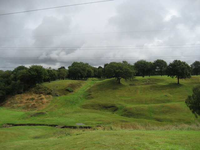
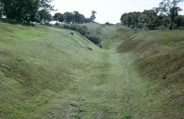
The fort stands at the south-side of the Antonine Wall (part of the north-west frontier) and, in particular, the section behind the fort (north and north-west side) with its deep-ditch and rampart is one of three that are extremely well-preserved, although the actual Roman wall itself, or what constituted as a wall at the time, has mostly disappeared leaving only the earthworks as a reminder. The Antonine Wall, built about AD 143, is actually a V-shaped ditch which was 15 Roman feet wide with a rampart of turf on a stone base, a military way that ran for 36 miles (40 Roman miles), linking the Firth of Clyde at Old Kilpatrick in the far west, to the Firth of Forth at Bo’ness in the east. It was built soon after AD 143 to a planned line, earlier set out by Julius Agricola (c 80 AD), by the legate Lollius Urbicus and named after the emporer at the time, Antoninus Pius; but militarily it was nothing like Hadrian’s Wall, although it was called ‘a permenent frontier’ at the time of building, and that’s what it was to remain – in the landscape at least.
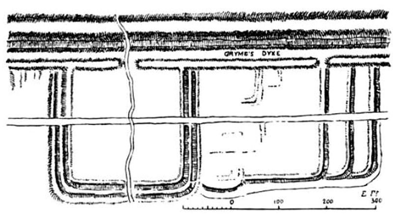
Rough Castle Fort, a drawing by William Roy 1755 (Photo Credit: Wikipedia)
The Rough Castle fort covered about 1 acre, so fairly small compared to some of the forts in England and Wales. It was called a ‘wall fort’ because it abutted up against a Roman wall, in this case the Antonine Wall. Typically it was square-shaped with curved corners but with no lookout towers, although there were the usual four side entrances at the N.S.E.W. Built around 142 AD as a temporary fort, spaced at a two mile interval with its near neighbours – Seabeg to the west and Watling Lodge to the east; at Watling Lodge there is another well-preserved section of the Antonine Wall. But Rough Castle only lasted for just over 20 years, and by 163-4 AD the wall and its 19 small forts and 14 temporary forts were abandoned, Hadrian’s Wall further to the south being occupied instead! However, for a short period around 210-11 AD Rough Castle was re-occupied. The double ditches and ramparts of the fort, and its annexe are well-preserved, especially at the east, south, and western sides, that at the north-side being the much deeper defensive ditch and steep rampart of the Roman wall.
During Archaeological excavations in 1902-3 the foundations of numerous buildings were discovered within the fort and, in the annexe a bath-house, including: an headquarters block, barrack block, commandant’s house and a granary; also a series of defensive pits (lilia) outside the Antonine ditch on the left front of the fort were found, according to the work ‘Ancient Monuments Scotland’, which goes on to say that: “Two inscriptions identify the garrison, the 6th Nervian cohort”, one of six infantry units of up to 500 men from north-eastern Gaul who were honoured with the title ‘Brittanica’, according to the very excellent work of I. A. Richmond ‘Roman Britain’. Further excavations took place at the fort in 1932, 1957 and 1961.
Sources:
Bedoyere, Guy de la., The Finds of Roman Britain, B.T. Batsford Ltd., London, 1989.
Breeze, David. J., Historic Scotland, Batsford Ltd., London SW6, 1998
Canmore/Rcahms Site Page http://canmore.rcahms.gov.uk/en/site/46803/details/rough+castle/
H. M. Stationery Office, Ancient Monuments Scotland, Illustrated Guide, Volume VI, Edinburgh, 1959.
Photo Credits (nos 1&3) http://en.wikipedia.org/wiki/Rough_Castle_Fort
Photo Credit (no 2) http://commons.wikimedia.org/wiki/File:Antonine_Wall_near_Rough_Castle_Fort.jpg
Richmond, I. A., The Pelican History Of England 1 Roman Britain, second edition, Penguin Books, Harmondsworth, Middlesex, 1963.
