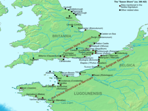
Map of The Saxon Shore Forts (Wikipedia)
There were originally 10 or possibly even 11 ‘Saxon Shore Forts’ (Litus Saxonicum) commanded by an officer with the title of ‘Comes litoris Saxonica per Britanniam’ or ‘Count of the Saxon Shore’. Most were built in the late third century though others have an earlier origin. Richborough incorporates older buildings, as does Reculver. Dover was already a militarised site. Nine are referred to in the Notitia Dignitatum, a military text from the late 4th early 5th century. A 10th fort may have existed at Walton Castle, near Felixstowe, but this has now been lost to the sea.
The forts are all similar in that they are located near sea harbours or river estuaries, suggesting that their purpose was to prevent sea-borne invaders getting inland. Each could support a substantial garrison either infantry or sailors. All are of a similar structure – massive walls with bastions for mounting ballistae and surrounding ditches and, ramparts for extra protection.
A parallel defence system contemporary with the Saxon Shore Forts the Litus Saxonicum exists on the other side of the Channel from Mardyck near Calais to the estuary of the Garonne. However this system is not as close knit with five of these forts not on navigable rivers. Rather the issue here seems to be the defence of key positions rather then a shoreline.
From the north we have Brancaster (Branodunum) OS grid ref: TF 7821 4404 located between Burnham Market and Hunstanton, covering 6 ½ acres of standard trapezoidal shape, and with walls 9 foot thick of which nothing now remains above ground.
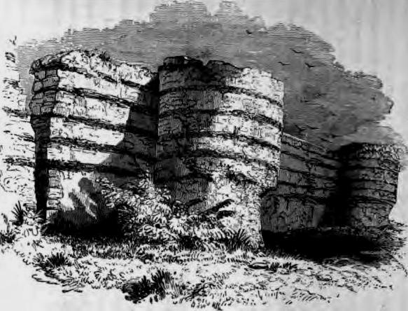
Mid-19th Century Illustration of Burgh Castle (Wikipedia).
Then Burgh Castle (possibly Gariannonum) OS grid ref: TG 4745 0461 is now well back from the sea with walls 11 foot in width and in places still 15 foot in height enclosing 5 acres. Three sides of the walls remain. Six bastions appear to have been added at a later date after the fort was constructed.
Further south in Essex lies Bradwell (OS grid ref: TM 0313 0810) on the Blackwater Estuary (possibly Othona) with sections of 3 walls originally surviving, one with a bastion.
On the Watsum River in Kent lies Reculver (Regullium) OS grid ref: TR 2274 6930 which was once on a broad waterway between the Isle of Thanet and the coast, but now sadly eroded by the sea. The walls of this fort were 8 feet thick surrounding an enclosure of standard Roman shape and protected by a ditch and earth rampart. Much has been lost to the sea. Also of note at Reculver are the ruins of a church founded about AD 669 by Egbert, King of Kent. There was a nave 37 feet long and a chancel with an apse. The towers, which remain, were added in the 12th Century.
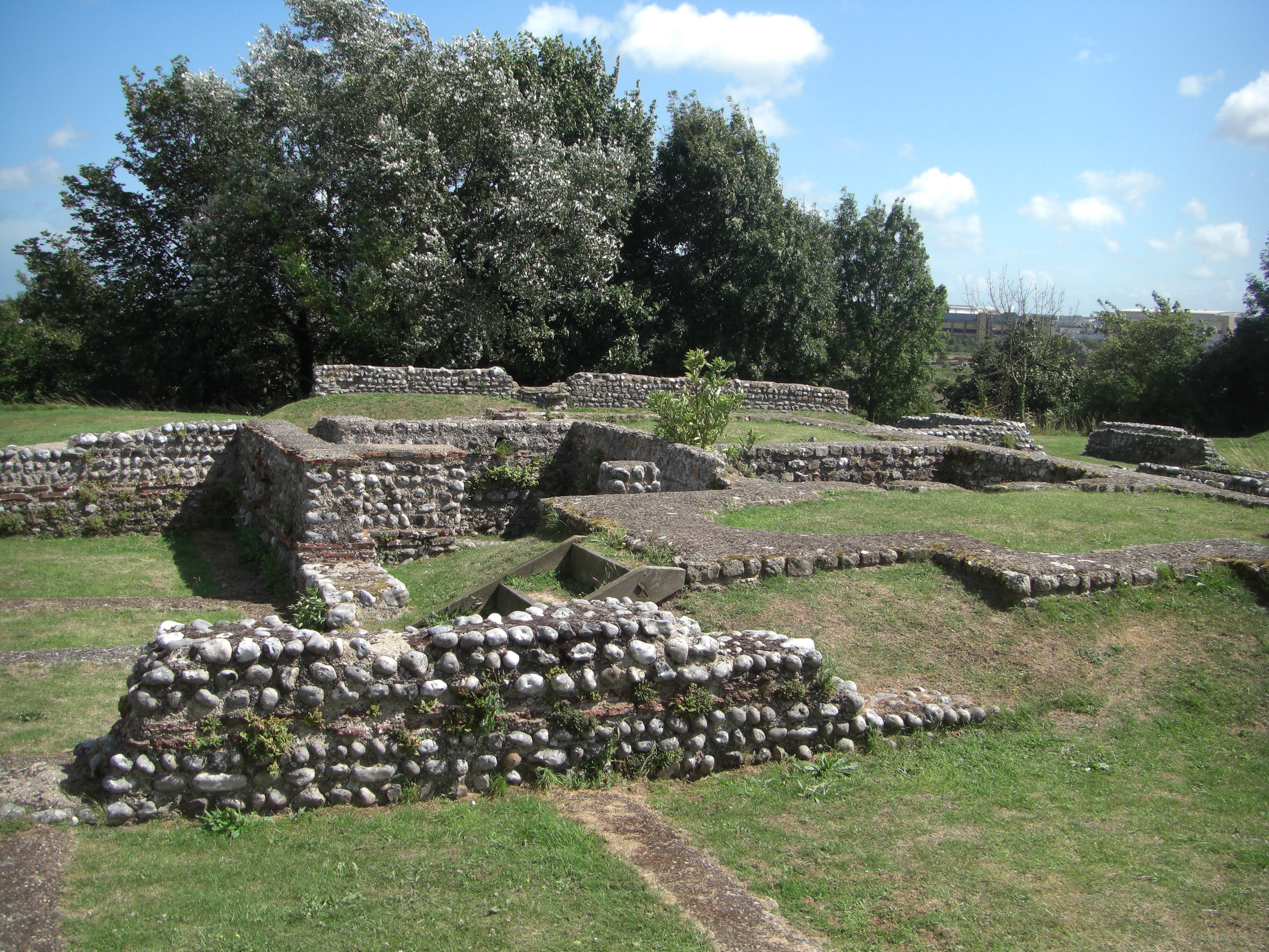
Richborough Roman/Saxon Fort (photo credit: Midnightblueowl -Wikipedia).
Richborough (Rutupiae) beside the river Stour at (OS grid ref: TR 3245 6018) has perhaps the most imposing remains, and the longest history. It is possible that this is where the Romans landed in AD43 under the command of Aulus Plautius. Defensive ditches have been found enclosing a large area. And 40 years later a marble monument in the form of a triumphal arch 82 feet tall with a façade of Italian granite was erected ‘possibly’ to commem-orate the event. The foundations remain. There is also evidence of occupation in the 2nd Century, when it seems to have been a civilian settlement with temples, an amphitheatre and a mansio (hotel). A fort with earth ramparts with triple ditches remains of which are extent dates from the second half of the third century with a stone walled fort of standard Roman shape and bastions replacing it soon after. At this time also the monument was converted into a look-out post. Finds from archaeological digs are housed in the site museum.
Dover (Dubris) OS grid ref: TR 3193 4133 lies buried under the modern town (Queen Street) and is more famous for its Pharos (lighthouse) explored elsewhere on this web site. The Fort dates from the 2nd Century – being reused later as part of the ‘Saxon Shore’ defence.
Lympne (Portus Lemanis) lies on Romney Marsh (on private land) OS grid ref: TR 1170 3420 and is marked by a few walls tilted at odd angles and, an east gate. The fort appears ho have been constructed as an irregular pentagon rather than of the usual trapezoidal shape.
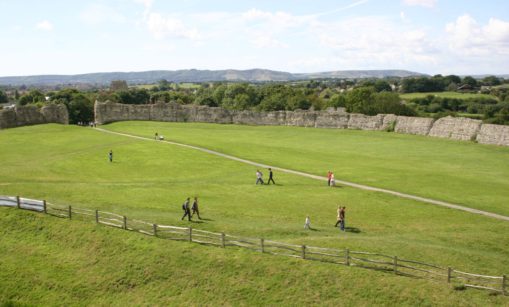
Pevensey Castle Roman Walls (photo credit: MortimerCat – for Wikipedia).
Pevensey (Anderida) OS grid ref: TQ 6388 0504 lies at the mouth of the River Ashbourne in Sussex. Excavations here have shown evidence of wooden buildings. Pevensey is unusual in that the walls defer from the usual square plan into an irregular oval enclosing some 10 acres. The 12-foot thick walls initially look Medieval, but are in fact largely Roman. Bastions were placed at intervals around the wall and still look very imposing today. Not only did the Normans reuse the castle building, a keep on the south eastern side, but it was again reused in the second world war; a pair of machine gun posts can be seen as can a ‘pillbox’ on top of one of the bastions.
Porchester (Portus Adurni) in Hampshire. On Verne Hill overlooking Portland Harbour OS grid ref: SU 6242 0452, completes the group. Of a square shape the walls have gates on the west and east and a defensive ditch surrounding them. There were originally 20 bastions and 14 survive. Archaeological evidence shows that a high status Anglo Saxon residence was established later within the walls. Again the building seems to have impressed the Normans. They resurfaced the walls and built a keep in the northwest corner. Other buildings followed in the 12th, 13th and 14th centuries. In the Southwest corner there is also a large church – part of an Augustan Priory built in 1133.
For most of the 19th and 20th Centuries two theories held sway over the reasons for the development of the Saxon Shore defences. The first was that they were there to control an existing settlement of Saxon migrants (there is some evidence of Saxon settlers in the archaeological records), the second to prevent Saxon marauders from plundering that part of the coast. Whilst this was probably the case with the second half of the 4th Century, it was not really the case with the 3rd Century, and archaeological evidence (coins) now suggests they were built in the late 3rd Century when the Saxons were presenting as troublesome pirates rather then invaders intent on plunder. It is more likely that they were established by the Gallic Emperor Cariusus – mentioned elsewhere on this website. It has also been suggested the forts were established to protect the supply of goods back and forth from and to the continent. All four theories may have merit at different times during the 3rd and 4th Centuries.
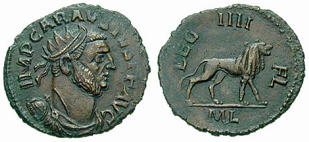
Antoninianus Carausius Coin c 290 AD (photo credit: Classical Numismatic Group, Inc. – for Wikipedia).
Carausius reigned from 286 to 293. According to the 4th Century writer Eutropius Carausius was of Belgic origin, had joined the fleet and had rapidly risen through the ranks bringing him to the attention of the Tetrarch – the two emperors and their two assistant Caesars who ruled the Roman world. He was put in charge of dealing with the Saxon Pirates but allegations were made against him that he had been allowing the Saxons to continue their piratical activities apprehending them and seizing their loot for himself. Recalled and fearing the worst he set himself up as Emperor in Northern Gaul and Britain. This theory suggests the forts were built by Carausius to defend his territory against the might of Rome. But the Tetrarch’s resources were stretched and Cariusius was tolerated instead. In 293 the Tetrarchy recovered Northern Gaul weakening Carausius’ position and leading to his assassinated by his Chief Minister, Allectus. Constantius Chlorus took his time but recovered Britain for the Empire in 296/7; Allectus being defeated and killed near Farnham.
Archaeological evidence shows that during the 4th Century the forts continued in use probably supplanted with a series of signal-stations, which could have provided warnings of incursions, using fire and smoke. When Rome withdrew from Britain at the beginning of the 5th Century the forts fell into disrepair. Internal buildings were mainly of wood so they disintegrated leaving just the walls as a reminder of what had been. 700 years later the walls were still standing and some of the forts were requisitioned by the Normans as defensive positions, as status symbols and, as accommodation for the elite of the new invaders.
Sources: Cottrell, Leonard., ‘The Roman Forts of the Saxon Shore’, HMSO, 1964.
https://en.wikipedia.org/wiki/Saxon_Shore
https://en.wikipedia.org/wiki/Richborough_Castle