The Journal Of Antiquities

Ancient Sites In Great Britain & Southern Ireland


Hollinshead Holy Well, Near Abbey Village, Lancashire

Well-House of Hollinshead Hall, Lancashire, by Margaret Clough (Wikipedia)

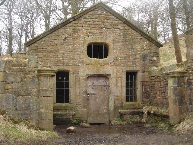
Well-House of Hollins-head Hall, by Margaret Clough (Geograph).

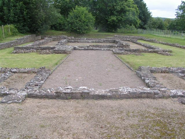
   OS Grid Reference SD 6637 1992. About a mile south-east of Abbey Village, near Blackburn, Lancashire, stand the scant ruins of Hollinshead Hall, a 14th century building that was actually a manor house and home to the famous Radcliffe family of Ordsall near Manchester. In the enclosed garden of the ruined hall is a well-house containing a holy well that used to have healing properties.The origins of the name Hollins-head probably derived from the Saxon place-name ‘Holy Head’ or even ‘Helig Weald’ which refers to a holy well or spring. Though the name ‘Holy Head’ might perhaps be derived from the well-head – the stone lion’s head in the well-house from the mouth of which the water issues. The well-house was probably a baptistery to which Roman Catholics resorted to during Penal times when priests were in hiding and any form of gathering in such a place was outlawed. Follow the Tockholes Road south out of Ryal Fold for about ½ a mile, then walk along the track on the right-hand side through the woods for 335 metres leading to the ruins of the hall, farmhouses, gardens and the medieval well-house.

   The author John Crawshaw writing in Source – The Holy Wells Journal, gives us a fair bit of interesting information with regard to the holy well. He says that: “The early history of the well is scanty, but it seems that a medieval well-house (with a superb vaulted stone roof) was ‘restored’ at some date during the 17th century.

   “This  restoration was probably carried out by the owners of the land on which the holy well stood, the powerfull recusant Radcliffe family of Ordsall Hall near Manchester.

Hollinshead Holy Well (illustration by John Crawshaw).

Hollinshead Holy Well by John Crawshaw.

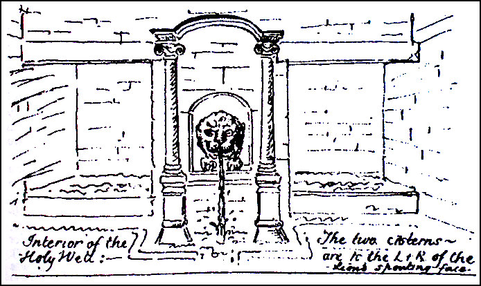
   Mr Crawshaw goes on to say that: “Unfortunately, though I have been researching its history for some years now, I have not been able to discover the holy wells’ dedication, which has been lost. Doubtless the site was very important, for the well-house itself is very grand indeed, and houses two baths in the form of rectangular cisterns, and there is also a fine retaining wall to the right of the compound, bearing traces of the Radcliffe coat-of arms. A member of the Radcliffe family lived in a house near the site, and it is highly probable that the well-house was a secret mass-centre and baptistery, a focus for recusant life in the area. I believe that there is sufficient evidence in the style of the building to show that is is a ‘disguised’ holy well house, perhaps built when persecution became a little easier during James the second’s reign: at any rate the style of the building is very much that of c. 1680s Lancastrian master masonry.

   “On the hillside, immediately behind and above the well-house, is a pool which probably represents the original holy well. It is a pretty big pool, oval-ish, and lined with ancient stones. The spring issues from the earth at the right-hand side, fills the pool, and from thence the water falls down into the two cisterns within the well-house itself.

   “Hollinshead Holy Well has a vague reputation of being haunted and also that its very pure water is good for eye troubles. Hollinshead Hall is referred to in Twycross’ Mansions of England (1846), where the well-house is mentioned, said to have been formerly called ‘The Holy Spring’, and visited by pilgrims who came for the water.

    Mr Crawshaw says of his visit to the well: “Visiting it on 18th October 1994, I was delighted to find that the holy well-house had not been vandalized, as I been informed recently. It is still in good order, except for some obscene graffiti and the fact that the door to the well-house is now locked with a large padlock, so that access……..is not now possible. However, the interior of the well-house can easily be seen through the two windows in the façade. The original pool behind the well-house is still full of water, and access to this pool is unrestricted.

   “The well is still referred to locally as a ‘Holy Well’, and I was present, back in late September 1988 at a well-dressing ceremony (the very first one to be held) at the Well. This was organized by the local Anglican priest, and very well con-ducted it was, too, says Mr Crawshaw.

   Author Richard Peace in ‘Lancashire Curiosities’, puts the question with regard to the holy well: Pagan or Catholic Spring? He says that: “Amidst the gardens of the ruined Hollinshead Hall lies a well-preserved outbuilding housing a stone carved lion’s head that emits a small spring of water. The spring falls into a central channel, surrounded by cisterns and benches on either side. This fascinating building is Hollinshead Well, whose original purpose is hotly debated. Its origin seems likely to be ancient. The vaulting inside may be from the 15th century whilst the covering is from the 18th century. Some believe it to be of pagan origin as it reportedly contains the water of five separate  springs, signaling the presence of the water-goddess. More recently its seems to have been used as a Catholic baptistery, with the two cisterns perhaps being used for male and female baptisms. Records show medieval pilgrims visited the well to try and cure ophthalmic complaints.”

   The author Edward J. Popham, writing in 1993, says this holy well used to be known as Ladyewell (Our Lady’s Well) and then locally called St Leonard’s Well. Presumably he is referring to the Hollinshead Well? It seems that he is.

Sources and other related websites:-

Crawshaw, John, (Hollinshead Hall Holy Well),  Source—The Holy Wells Journal, New Series No 2—Winter 1994, Pen-y-Bont, Bont Newydd, Cefn, St Asaph, Clwyd, 1994.

Peace, Richard, Lancashire Curiosities, The Dovecot Press Ltd., Stanbridge, Wimborne, Dorset, 1997.

Popham, Edward J., Where Shall We Go In The Ribble Valley? The Salford Catholic Truth Society, 1993.

    https://en.wikipedia.org/wiki/Hollinshead_Hall#/media/File:The_Well_House,_Hollinshead_Hall_ruins_-_geograph.org.uk_-_116184.jpg

http://people.bath.ac.uk/liskmj/living-spring/sourcearchive/ns2/ns2jc1.htm

https://en.wikipedia.org/wiki/Hollinshead_Hall

https://megalithix.wordpress.com/2014/10/25/holy-well-hollinshead/

Hollinshead Hall ruins and Well House, near Tockholes

                                                                                © Ray Spencer, The Journal Of Antiquities, 2017.


2 Comments

Blackheath Circle, Near Todmorden, West Yorkshire

Blackheath Cairn Circle is only just visible in the middle distance marked by the red arrow.

OS Grid Reference: SD 94339 25434. About 1 mile north of Todmorden, west Yorkshire, near the southern side of Todmorden Golf Course there is a Bronze Age cairn circle, ring cairn or round barrow. This is usually referred to as Blackheath Circle, but locally it is called Frying Pan Circle, because of its circular shape. It also sometimes goes under the name ‘Blackheath Ringbank Cemetery’, while in the past it had been called ‘Roman Barrow’. This quite large circular feature is now part of the golf-course, but at ground-level it is hardly noticeable today apart from a slight raised bank at either side of the circle; the north side being very denuded. The grass is often a brownish colour where the cairn’s outer raised ring shows up after being mowed. Blackheath cairn circle is situated at over 900 feet above sea-level. When it was excavated nineteen burial cists were discovered along with a number of cremation urns, food vessels and grave-goods. Very sadly, though, this prehistoric cairn circle has been taken over by the golf-course – of all things! 

Blackheath Circle is best reached from Kebs Lane, Eastwood Road and then Hey Head Lane, which goes past the golf course. About halfway down the lane on the right-hand side there is a wall-stile and a footpath running west beside a wall at the northern edge of the course. The Bronze Age cairn circle is 350m along this path through the trees and, at the far end, just in front of the large gap in the wall running across.

The following information is taken from ‘Life In Bronze Age Times – A Resource Book For Teachers’. It says of the site: “Blackheath is a Prehistoric cemetery situated at 940 feet (287) O.D., on a south facing slope. On excavation it was found to comprise a circular bank of earth 3 feet (1m) high in which large stones were regularly arranged. The circle was 100 feet (30m) in diameter. There was no obvious entrance. A circular area with a floor of beaten clay was enclosed by the bank.

“There were cairns both inside the circle and in the earth bank. These revealed pits and cists containing cremation burials. Nineteen were found in all. Some of the cremations were found in urns. The urns were all upright and buried just below the surface. A characteristic feature of the urned cremations was the use of a small inverted vessel placed upside down in the urn and serving as a lid.

“The central urn is 11 inches (20 cm) high. The collar shows impressions made by twisted cord. As well as bones, the urn contained a small decorated pygmy vessel . In this vessel there was a bronze dagger, a bone pin and a bronze pin.

Plan of Blackheath Ringbank Cemeterey, near Todmorden.

Plan of Blackheath Ringbank Cemetery, near Todmorden.

Collared urns found at Blackheath Circle.

Collared urns found at Blackheath Circle.

Another urn also contained a pygmy vessel together with beads of faience, amber, jet and shale, two bone pins, flint flakes and a leaf shaped arrowhead. Two of the urns were covered by other vessels, one of which may have been a food vessel. With the exception of the two urns in the bank, all  the finds  were in the  eastern half  of the  circle. In the rest of the circle there were areas where the floor showed evidence of being baked by a great heat. These were covered with a layer of charcoal 1-2 inches thick. It was suggested that these may have been the areas where the bodies were cremated. Two deep pits were also found, possibly the holes where clay was dug out of the ground for making the pots. Areas of coarse sandstone were discovered. This could have been used for grinding down and mixing with the clay.  There was at least one (possibly four) kilns.  These were cist-like structures surrounded by baked floors where the pottery was fired.”

 Author Paul Bennett in his work ‘The Old Stones of Elmet”, says that: “The archaic West Yorkshire game of Knurr and Spell used to be played inside this circle. This is a game played with a wooden ball (the knurr) which is released by a spring from a small brass cup at the end of a tongue of steel (the spell). When the player touches the spring the ball flies in the air and is struck with a bat. Quite why they chose this place is unknown.”

Mr Bennett goes on to say with regard to Blackheath Circle that: “It was accurately described for the first time by Robert Law (1898) in  the Halifax Naturalist; but a most eloquent detail of the site was given several years later by J. Lawson Russell (1906) who, even then, told that it had been “”cut into again and again by deep plough ruts, marked out by tufts and hummocks of varying height.” 

“The first detailed excavation was done on July 7, 1898, when the site was examined in quadrants and turf cut accordingly. “”The diameter of the circle was 100ft (30.5m), ie. measuring ridge to ridge, from north to south, Russell told us.    ………There were a number of large stones set around the edge of the circle, some of which were still in situ in 1898. This led subsequent archaeologists to think the site was originally a stone circle. It may have been, but I’m sure the excavators of the period would have made such allusions.  Certainly they thought it had some ritual import.  How can we disagree!?”, says Mr Bennett. 

There is another “possible” circular feature just to the east of the large cairn circle at SD 94454 25507. However, this almost destroyed circle is smaller and very difficult to make out as it is now, sadly, incorporated into a raised golfing barrow, but the outer ring of this circle often shows up at one end as brownish grass in the summer months, especially where the golfing barrow slopes down to ground level.

Sources and other related websites:-

Bennett, Paul, The Old Stones of Elmet, Capall Bann Publishing, Milverton, Somerset, 2001.

Thomlinson, Sarah & O’ Donnell, John, Life In Bronze Age Times – A Resource Book For Teachers, Curriculum Development Centre, Burnley.

https://megalithix.wordpress.com/2010/11/19/blackheath-circle/

http://www.pastscape.org.uk/hob.aspx?hob_id=46095

http://www.calderdale.gov.uk/v2/residents/leisure-and-culture/local-history-and-heritage/glimpse-past/archaeology

                                                                                   © Ray Spencer, The Journal Of Antiquities, 2017.


1 Comment

Caerwent Roman Town, Monmouthshire, South Wales, Part 1.

Caerwent Roman Town Walls, South Wales,

Caerwent Roman Town Walls, South Wales,

OS Grid Reference: ST 4692 9062. The Roman town of Venta Silurium, founded by the Romans in 75 AD, is now the modern village of Caerwent in Monmouthshire, and is located just to the south of the A48 road and just west of the M48. It is 5 miles west of Chepstow and 11 miles east of Newport. The modern village is built around the Roman ruins, which are some of the best preserved in Europe. Large sections of the Roman town walls are still in place, according to Wikipedia. The River Severn is a couple of miles to the south. In the village is the medieval church of Saints Stephen and Tathan, an ancient foundation which may date back to the early 6th century AD? Housed in the church porch are two Roman inscribed stones. The Roman legionary fortress of Caerleon is 8 miles to the west.

Under the Romans Caerwent was known as Venta Silurium (Silurum) or in translation ‘market of the Silures’. The Silures had been an Iron Age tribe occupying south-east Wales and had presented an irritation to the conquest for the Romans. In the early days of the invasion they had sheltered the Romans’ public-enemy-number-one, Caratacus, until he fled to what he thought was the safety of Cartimandua’s Brigantines. She handed him over to the Romans, a good will gesture the Romans would not forget. Gradually following the establish-ment of the legionary Fortress at Caerleon around AD 74 and a series of auxiliary forts across the south – the Silures were subdued. In accordance with Roman Policy of Pax Romana once subdued the Silures were encouraged to settle, although for a time they remained under military rule. The cost of military rule was enormous so it would not have been long before a civil administration would have been established. The administrative capital Venta Silurium was sited astride the mainroad from Gloucester to Caerleon. The town sits on a slight rise in the middle of a valley surrounded by good agricultural land in an area that had been occupied by the Romans since AD 50.

Caerwent Roman Town Walls (Illustration).

Caerwent Roman Town Walls (Illustration).

The Extant Remains:  The total circuit of the wall exceeds 1 mile en-closing an area of 4 acres divided into 20 plots (insulae). The walls are the best preserved of any Roman town in Britain. The internal and external roads would have been of rammed gravel with cambered sides to allow rainwater to run off; and the local civitas (administration) was responsible for repair and resurfacing. The early settlement appears to have had a sprawl of properties along the main road. But the layout we see today is later, possibly even as late as the early third century, which might account for certain oddities – the walls are not square – the insular somewhat jumbled. The actual population was probably about 3800 individuals at its height. Public buildings are of the standard Roman variety.  A Forum Basilica complex occupied the whole insulae VIII; the site of several temple complexes are known and one is visible to the east of the Forum Basilica, another has been excavated to the south in insulae XII, and a third is possible outside the east gate. Whilst the largest houses show evidence of private baths. Public baths have been excavated in insulae XIII.  A mansio which was a kind of inn frequen-ted by members of the Postal Service and other officials has been located in insulae XVIII to the left of the south gate. This was a courtyard building with a forecourt where the weary traveler would have dismounted. Several rooms had hypocausts, at least one having a mosaic floor. A latrine lay in a corner of the courtyard surrounded on three sides by a sewer, suggesting the building was not just a domestic building.

Caerwent Roman Town Wall (photo: Mortimer-Cat - Wikipedia).

Caerwent Roman Town Wall by MortimerCat – Wikipedia).

The Town Walls:  The town had 4 gates. The main ones were the West and East gates opening onto the town’s main thoroughfare. The West Gate originally had a double arched carriageway flanked on either side by a square tower projecting out in front of the wall. Little now survives except part of the south tower and its masonry floor. The west wall, however, built of limestone running from the west gate to the south-west corner survives in places to a remarkable 5 metres (17 feet) and is backed by an earthen bank. From these remains the wall is believed to have been about 7.5 metres in height (25 feet) with a walkway and parapet – none of which survives anywhere along the wall. The wall would also have been originally vertical on both sides. But the method of construction can be determined from this section of the wall. Rows of limestone were laid front and back and the core then filled in with more pieces of limestone and mortar leaving a distinctive herringbone pattern. The wall was clearly built in sections and by different gangs.

Unlike the West Wall the South Wall is not completely straight but bows outwards in its middle section. It also stands to a magnificent 5m (17 feet) in parts. Also, unlike the West Wall the remains of six hollow 5-sided towers (bastions) project from the walls but not bonded to the wall – meaning they are later additions probably 4th century. A new outer ditch had to be made to allow for the towers. The fourth tower from the west is the best-persevered standing to a height of 4m (13ft). Internal joist holes in this tower suggest there were originally two wooded floors beside the ground floor with a top platform also of wood. The South Gate consisted of a single arched carriageway. The piers survive and may originally have supported an overhead chamber. Both sides of the passage were originally recessed allowing the heavy doors to swing back. The carriageway was made up of stones and iron clinker with a slab-lined culvert. At a later date the carriageway was blocked.

The East Wall is also bowed. As with the West Wall there are no external towers. Sadly all that remains of the East Gate, which was constructed the same as the West Gate is the inner angle of the south tower. The East Wall is some 30m shorter than the west wall so avoiding a marshy area and taking advantage of higher ground.

The North Wall is the least well preserved of the four walls. Surviving to just 1.8m (6 feet) in height in parts but it is known that, like the South Wall, it had 5 towers of which little sur-vives. Like the South Gate the North Gate is not centrally placed though the plan is similar with a single carriageway. Sockets for the gates can still be seen. Again and probably in the late Roman Period the North Gate was blocked off – being filled in with rubble from other demolished buildings. The North West Tower of the gate survives to a height if 2.4 metres (8 feet).

Roman Temple at Caerwent by andy dolman (Geograph)

Roman Temple at Caerwent by andy dolman (Geograph)

The Romano-Celtic Temple: The remains of the temple lie to the east of the forum. Excavations were begun in 1908 and concluded between 1984 and 1991. No trace of the deity worshiped here was found. The construction was of traditional Romano-Celtic design. The extant remains show a square inner shrine (cella) with an unusual back projection surrounded by another separate room known as the ambulatory. This would have contained a statue of the deity. The entrance porch would originally have had steps, whilst the small projections at the entrance are probably the bases for pilasters (rectangular columns). The temple stands in its own courtyard surrounded by a boarder wall on 3 sides and an entrance hallway with a central doorway and a tessellated floor on the fourth side facing the main street. Few people actually entered the cella; most of the congregation would have been expected to gather in the courtyard between the hallway and the temple proper.

The Forum Basilica: A central feature of all main roman towns wherever you went in the Empire was the Forum Basilica essentially an administrative assembly hall and market place. The Caerwent example occupies the whole of insulae VIII. Building began in the early second century probably under the auspices of the 2nd Augustan Legion based at Caerleon, as the design is similar to that of the headquarters building there. It was largely rebuilt in the third century probably after structural problems were identified. It continued in use as a forum basilica until after 340 AD when it seems to have been converted into industrial units and was demolished at the end of the 4th Century. It was first excavated in 1907 and again between 1987-1992. The Basilica and the northern end of the forum remain uncovered for public view.

The basilica was 56m (182ft) by 80m (260ft) and would have towered over surrounding buildings but is small by other examples in Roman Britain. Access to the basilica was by steps some of which have survived. There was also access from the side streets. In plan the basilica comprises a great hall, and a rear range of rooms and chambers. On excavation the parts of the walls were found to have survived to 1.8m (6 ft) having been incorporated into early 19th Century farm buildings. The external walls were massive requiring foundations up to 1.8m (6ft) with Corinthian columns rising to a height of about 9.2m (30ft) rendered and painted off-white. It is believed the basilica was in excess of 20m (65ft) in height. The roof initially of tile was partly replaced by sandstone slabs at the end of the third century. The hall would have been used for public meetings and ceremonies. The chambers at each end would have served as tribunals for the local magistrates to hear cases. The rear ranges of rooms were offices for local administrators and their records, while the central room would have held a statue of the reigning Emperor, and the largest room known as the curia would have acted as a council chamber. The Forum is surrounded on 3 sides by a range of rooms entered on the fourth side from the main street through an archway. These rooms would have provided space for shops, taverns and offices, with a larger open front that would have been closed with wooden shutters. A second storey above would have provided yet more rooms.

To be continued………

Sources and related websites:-

BBC Publication, Roman Britain, The British Broadcasting Corporation, London, 1966.

Brewer, Richard J., Caerwent Roman Town, Cadw Welsh Historic Monuments, 1993.

Evans, J. Barrie, The Parish Church Of St. Stephen & St. Tathan Caerwent – A Short Guide.

Wilson, J. A., A Guide to the Roman Remains in Britain, 4th Edition, Constable, 2002.  Constable,

https://en.wikipedia.org/wiki/Caerwent

https://en.wikipedia.org/wiki/Venta_Silurum

Photo from Wikipedia website – Click below for further details:   https://en.wikipedia.org/wiki/Venta_Silurum#/media/File:CaerwentWall.jpg

http://www.geograph.org.uk/photo/486475

http://cadw.gov.wales/daysout/caerwent-roman-town/?lang=en

https://museum.wales/1493/

                                                     © Ray Spencer, The Journal Of Antiquities, 2017.