The Journal Of Antiquities

Ancient Sites In Great Britain & Southern Ireland


1 Comment

Wind Hill Cairn, Cheesden, Near Rochdale, Greater Manchester

Wind Hill Cairn at Cheesden, near Roch- dale (the north-side).

   OS Grid Reference: SD 83262 14945. In a farmer’s field at the side of Ashworth road, Cheesden, near Rochdale, Greater Manchester, is Wind Hill Cairn, dating from the Beaker Period of the Bronze Age. Now it is nothing more than a low, grassy mound at either side of the more recent drystone wall. The cairn stands at the north side of Wind Hill, 298m above sea-level and overlooking Knowl Moor, with Knowl Hill itself rising over to the east beyond Edenfield road. A little further down the lane is Ashworth Moor Reservoir and, on the opposite side of Edenfield Road, is the famous Owd Betts public house. The cairn is in a damaged condition due partly, at its north-side, to farming, but on its south-side there is less damage and has, therefore, kept its circular identity. There is a footpath heading east across Wind Hill from Ashworth road, just above Wind Hill farm and the wind turbine, but the cairn is partly on private land (at its northern-side) where there is a locked metal gate next to the wall – beside Ashworth road.

Wind Hill Cairn, Cheesden (at the northeastern side).

Wind Hill Cairn at Cheesden near Roch- dale (the south-side).

   Originally Wind Hill Bronze Age cairn had a diameter of 10.45m (34 feet) and a height of 0.75m (2-3 feet) but it is now less than that due to destruction at its N side. According to the ‘Lancashire Archaeological Bulletin’ (1984) with the primary reference: Tyson, N (1972) at the end of the excavations by Bury Archaeological Group between 1968-72: this is a ruined cairn with a kerb of horizontal slabs. There was an opening to the E which was 6 feet wide with a subrectangular area outside that was defined by inward-leaning slabs that are further enclosed by a “satellite kerb”. Both of these kerbs were finally concealed. No grave pits were found, but at the cairn’s centre a flint knife, pebble hammer and a V-bored ‘jet’ button were discovered. Further to this information: there was a cist of sand-stones at the E side. The central and W parts of the cairn were denuded; the E and S sides were in a better condition and still visible. The dry-stone wall running in a straight-line through the middle of the mound ‘was’ dug deep into the structure, causing further destruction, and some of the stonework from the cist may have ended up in the wall itself, or could still be in ‘situ’ in the mound? There looks to be another “possible” tumulus at SD 83461 15136, some 290m to the east.

Knowl Moor & Knowl Hill seen from Ashworth Road, Cheesden.

   In 1905 a Late Bronze Age socketed axe (palstave) was dug up by workmen building the Ash-worth Moor Reservoir, just along the road from Wind Hill cairn. There have also been a number of archaeological finds on Knowl Moor and on Knowl Hill itself including arrowheads in a variety of shapes: lozenge, leaf, stemmed and barbed, and many flints in varying sizes and a thumbstone. It would seem, though, that these finds have not originated from ‘settlements’, but from pre-historic man simply roaming the higher ground above the forested areas beside the river Roch – where today we see the highly populated towns of Rochdale, Heywood and Bury. On Hamer Hill (Rooley Moor) above the town of Rochdale – some recumbent stones were recently discovered which has led archaeologists to consider the distinct possibility that they form a stone circle, and on nearby Hunger Hill there are possible burial mounds. There have also been a number of coin finds from the Roman period in the Rochdale and Heywood areas.

Sources of information and related websites:-

Lancashire Archaeological Bulletin, Vol 10, No. 2/3, May & July, 1984.

Tyson, N., A Bronze Age Cairn at Wind Hill, Heywood, Lancs. Bury Archaeological Group, 1972.

http://www.buryarchaeologicalgroup.co.uk/windhill.html

http://heywoodmonkey.blogspot.co.uk/2012/04/bronze-age-heywood-beaker-th-moss.html

https://lancsarchaeology.wordpress.com/2009/02/13/recent-archaeolgical-discoveries-in-south-east-lancashire/

https://en.wikipedia.org/wiki/Cheesden_Valley

http://www.megalithic.co.uk/article.php?sid=18858

                                                                                  © Ray Spencer, The Journal Of Antiquities, 2017.


1 Comment

The Knave Hill Burial Mounds, Near Nelson, Lancashire

Knave Hill long barrow near Nelson, Lancashire

   OS Grid Reference: SD 89636 36991. On the lower slope of Knave Hill between Walton Spire and Float Bridge Farm, 2 miles east of Nelson, Lancashire, there are two burial mounds, one of which is quite a large, well defined long barrow, while the other one close-by is a smaller mound but is also probably a long barrow. They are thought to have originally been built in the early Bronze Age, but then in the 10th century AD to have been re-used for the burial of Viking warriors who had died in the slaughter of the Battle of Brunanburh (937 AD) which may have been fought in the vicinity of Knave Hill, or a few miles away in the Burnley area near the river Brun. There are 2 or 3 other small mounds in the vicinity, one of which is just visible at the northwest side of Knave Hill. The hill itself is sometimes spelt “Nave Hill.” To reach the site from Nelson town centre head up Netherfield road and then to the top of Barkerhouse road. Then turn left, then right, and follow Delves Lane (with Walton Spire on your left side). At the junction of four lanes go straight ahead and down the hill. On the left is a farm track (footpath) to Knave Hill farm. The mounds lie a short distance to the east of the modern barns.

Knave Hill long barrow.

   In a most excellent article for ‘Pendle & Burnley’ Magazine by the local historian by Mr H. Hindle (1987) we learn that “Knave Hill farm, only two fields below the ancient monolith (Walton Spire) probably derives its name from the Nave Hill burial, a long barrow measuring approximately 2oo feet long by 120 feet wide, and 14 feet high, close to which are two smaller round barrows. Collins New English Dictionary explains ‘Nave’ as the middle or body of a Church, so called because of its resemblance in shape to an inverted ship. Another indication to the antiquity of mans presence in the area is the nearby Ringstone Hill and the countless number of cairns and burial mounds.”

Knave Hill near Walton Spire (smaller mound).

   The other mound lies just a little to the east of the larger, long barrow, but is much smaller in overall size. This mound measures roughly 126 feet long, 90 feet wide, and is about 7 feet in height. It could be that this smaller mound is also a long barrow, with its origins in the early Bronze Age but re-used in the 10th century AD. However, these two mounds or barrows are not recorded on any OS maps as far as I can tell, but we do have three or so sources of information with regard to their history – those sources being H. Hindle, Thomas T. Wilkinson (19th century antiquarian of Burnley Grammar School) and John A. Clayton, who mentions these burial mounds in his works of 2006 and 2014. There is another burial mound (possibly even two mounds) at the northwest side of Knave Hill, close to Shelfield lane which skirts the hill upon which is Walton Spire (see link below), a Victorian cross that sits on top of an ancient battle-stone that may have its origins in the 10th century AD, or maybe even earlier. Knave, in place-name form, was probably originally Cnebba or Cnabha (Hill of Cnebba). There is also Jeppe Knaves Grave, a Bronze Age cairn, near Sabden in Lancashire (see link below). And there is a Knave Hill near Todmorden, west Yorkshire.

Knave Hill burial mounds (at centre) and other “possible” mounds, from Shelfield Lane.

   The Battle of Brunanburh in 937 AD was fought by a collection of rag-tag armies of Celts, Saxons, Norsemen and some others. King Athelstan and the Saxons ‘were’ victorious in the said battle. But where was the Battle of Brunanburh fought? Mr Hindle offers a local place-name: he suggests Emmot in the Forest of Trawden being a strong possibility. But Thomas T. Wilkinson writing in the mid-19th century offers several other possibilities: Saxifield and Daneshouse near the River Brun in Burnley, or between Warcock Hill, near the Long Causeway at Stipernden, and another Warcock Hill at the north side of Thursden Valley. Mereclough near Burnley is another contender for the battle site as there is an area there called “Battlefield”. Bonfire Hill between Briercliffe and Swinden is another strong possibility. Or could it have taken place on the moors above Bacup, Lancashire, or even at Bromborough on the Wirral? We will probably never know.

Sources and other related websites:-

Hindle, H., Colne & Surrounding Areas (article in Pendle & Burnley) Magazine No. 4 (Christmas Issue), Valley Press, Ramsbottom, Bury, Lancs., 1987.

Clayton, John A., Valley of The Drawn Sword, Barrowford Press, 2006. 

Clayton, John A., Burnley And Pendle Archaeology – Part One – Ice Age to Early Bronze Age, Barrowford Press, 2914.

https://thejournalofantiquities.com/2012/05/01/walton-spire-nelson-lancashire/

https://thejournalofantiquities.com/2013/10/10/jeppe-knaves-grave-sabden-lancashire/

http://www.barrowford.org/page123.html

http://placenames.org.uk/browse/mads/epns-deep-32-d-mappedname-003089

                                                                             © Ray Spencer, The Journal Of Antiquities, 2017.


1 Comment

Medieval Stone Carving In Marsden Park, Marsden, West Yorkshire

The Laycock Memorial in Marsden Park by Humphrey Bolton (Wikimedia)

   OS Grid Reference: SE 05080 11474. At the base of a memorial to the Lancashire poet Samuel Laycock in Marsden Park at Marsden, 8 miles southwest of Huddersfield, west Yorkshire, there is  a curious carved stone, which has been called  ‘Celtic’  by local historians down the years. It is strangely carved with elements of nature that do indeed seem to be “Celtic” in origin. However, the stone is more likely to be late medieval. But where did this curious carved stone come from? No one seems to know. Maybe it came from some Medieval church or priory (though there is no record of that), or from some sacred grove beside a riverbank. The monument was actually set up to commemorate the Lancashire dialect poet Samuel Laycock (1826-93) who was born in Marsden, but his poetry was mostly about Lancashire and the ‘hardships’ of the Cotton Industry. Laycock died in Blackpool, Lancashire. The monument with its curious carved stone stand close by the bandstand in Marsden Park near Carrs Road. So just head for the bandstand and the monument is on the other side – just opposite the war memorial – dedicated to local men who died in the Great War.

Celtic Stone in Marsden Park, at Marsden, west Yorkshire.

   Apparantly the curious carved stone was found at Marsden in the late 19th century and then in 1911 it was seen fit to place it at the base of Samuel Laycock’s memorial in Marsden Park. But why? Maybe it was seen as ‘a fitting tribute’ to such a great poetic genius for Samuel Laycock was just that. The stone is thought to be Late Medieval and to date probably from somewhere be-tween the 14th-16th centuries, but could it be much earlier? A few local historians have con-sidered it to be Celtic in origin! Well at least the carvings look to be Celtic! And also carved on the stone is what looks to be the head of a Celtic sun god with sunrays radiating from it. Or is this carving a depiction of ‘The Tree of Life’- maybe. Another theory being that the oval-shaped face is that of a Celtic saint complete with a halo; the crown of oak leaves being associated with saints of the Old British Church both in folklore and literature.

   In an article called Reading the Environment by David Fletcher & David Ellis in the ‘Pennine’ magazine (1980) we are told about this curious Celtic stone in Marsden Park. They say that: “At the base of this modest monument is a mysterious stone carved in low relief depicting an oval-shaped face with a garland or crown of oak leaves, acorns and flowers. This stone was found somewhere in Marsden  during the last century, no-one seems to know exactly where, but the local worthies realizing its antiquity placed it at the feet of the local bard when his memorial was erected in 1911. Nothing could be more appropriate because it is my opinion that this mysterious stone can introduce us to a people who inhabited the Pennines for perhaps a thousand years—the Celts.”

   Fletcher and Ellis go on to say that: “The symbolic head with an oval face, and the crown of oak leaves suggest to me that this was part of a pagan shrine and who knows, perhaps it was the focus of worship in a sacred grove by the river Colne.”

Sources and other related websites:-

Fletcher, David & Ellis, David, (Reading the Environment article), Pennine magazine (No 5), Pennine Heritage Ltd., Pennine Development Trust, Hebden Bridge, West Yorks, June/July 1980.

https://commons.wikimedia.org/wiki/Category:Marsden,_West_Yorkshire#/media/File:The_Laycock

http://northernantiquarian.forumotion.net/t350-stone-in-marsden-park-marsden-west-yorkshire

https://en.wikipedia.org/wiki/Marsden,_West_Yorkshire

https://en.wikipedia.org/wiki/Samuel_Laycock

http://halfwayhike.com/2014/02/03/a-marsden-poetry-trail/

                                                                                  © Ray Spencer, The Journal Of Antiquities, 2017.


1 Comment

Caerwent Roman Town, Monmouthshire, South Wales, Part 2.

Caerwent Roman Town Walls, South Wales,

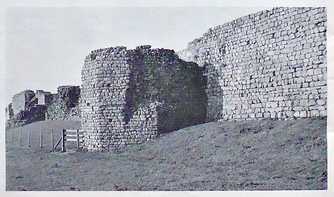
Caerwent Roman Town Walls, South Wales.

OS Grid Reference: ST 4692 9062. The Roman town of Venta Silurium, founded by the Romans in 75 AD, is now the modern village of Caerwent in Monmouthshire, and is located just to the south of the A48 road and just west of the M48. It is 5 miles west of Chepstow and 11 miles east of Newport. The modern village is built around the Roman ruins, which are some of the best preserved in Europe. Large sections of the Roman town walls are still in place, according to Wikipedia. The River Severn is a couple of miles to the south. In the village is the medieval church of Saints Stephen and Tathan, an ancient foundation which may date back to the early 6th century AD? Housed in the church porch are two Roman inscribed stones. The Roman legionary fortress of Caerleon is 8 miles to the west.

Continued from part 1:-

Typical Roman shop (illustration).

A typical Roman shop (illustration).

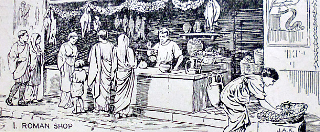
Pound Lane Shops And Houses. Shops:- The remains of these buildings were excavated in 1947-8, part of insulae VII. As is typical of these buildings the commercial part of the property occupies the front and the residential the back. Several phases of construction and re-development are also noticeable. Two narrow-strip buildings occupied the plot in the mid-2nd century separated by a passage. Each had a large work space/shop at the front and 4 or 5 residential rooms at the back. The buildings were single storey. It is uncertain but possible that the upper parts were of timber. The floors of the living areas were of concrete and the roofs were tiled while the walls were plastered and painted. The shop to the west was probably a blacksmith, the one to the east is unknown. At the beginning of the 3rd century both buildings were joined as one with some alterations. Again, it appears to be the blacksmith who had prospered. Towards the middle of the 4th century further alterations show that the blacksmith family who lived here became even more prosperous. The rooms were enlarged, two had mosaic floors, even the roof tiles were re-placed by stone slabs, and columns added a decorative feel to the front of the building, with a courtyard replacing the front of what had been the second shop. This once again illustrates that by the mid 4th century Britain was still a prosperous place to live. The building took on the feel of a very smart townhouse. The house was still occupied by the beginning of the 5th century, but evidence of industrial activity in some of the rooms suggests that its status had declined dramatically in-line with the waning of Roman influence and fortunes.

The Courtyard House: The remains of this building lie to the rear of the shops occupying the northwest corner of insulae VII. Two wings of the house have been excavated. The plan is of standard courtyard design and dating from the fist half of the 4th Century AD. Before this date the area appears to have been just an open space. The West Wing fronts onto a side street today known as Pound Lane. A Total of 13 rooms of varying size with only the lowest courses and foundations surviving are visible. The south wing had 5 rooms as did the west wing but all smaller than the south wing so perhaps they were bedrooms. Most were found to have floors of yellow concrete but one had a mosaic laid on stone-slabs beneath which was found a hypocaust system. The Romans not only invented concrete but also central heating. During the excavation traces of painted wall-plaster were found. It is quite possible that the house had an upper storey, as there was some evidence of a staircase. In keeping with its 4th century origins the house was roofed with stone-slabs. Part of the courtyard surrounding the house was paved and an enclosure to the north suggests a small garden.

Time Team visited in 2008 – their remit to explore the areas that had not been investigated. Mick Aston had hoped to look for medieval remains as he did not like the Roman’s, but was told by the dig’s lead archaeologist that they did not have time. They did ‘goephys’ and dug trenches in Insulae XIV opposite the Romano-Celtic Temple where they found more shops and, Insulae 1, where they found a large town-house with private bathing facilities similar to others found in the suburbs of the town. The best find had to be the penknife handle with two gladiators – someone’s once prize possession and one of only two found in the UK.

Later History: After the Roman occupation ended Caerwent became the administrative centre for the Kingdom of Gwent. The name Caerwent translates from the Welsh as ‘Fort of Gwent’. Post-Roman metalwork (broaches and fastening pins have been found, dating to between the 4th-7th centuries AD). The town is mentioned in the ‘Roman Cosmology’, a treatise written in the 7th century but based on an earlier account. It is then mentioned in the Life of Tatheus written in the first half of the 12th century. The saint came from Ireland and after performing a number of miracles was given the site of the Roman Town by the local king, Caradoc, to set up a monastic settlement. In 1910 a trench was dug just outside the East Gate where 30 skeletons were found within a cist of stone slabs of post roman date across the wall of a Roman building. A number of people thought the bones included those of St Tatheus. And in 1912, with due ceremony, the bones were interred in a coffin in the south aisle of St Stephen’s church. In favour of the reburial was a later discovery that a gift of 3 bones of St Tatheus had been made to Tewkesbury abbey in 1235 and that the note records that: St Tatheus is ‘buried at Caerwent’. Against is the fact that several other cist graves dating from the 4th-9th centuries AD have been found at Caerwent. All are of Christian origin. V.E Nash Williams’ interpretation of a structure built later over the west end of the Public Baths as an early Christian Church, has also now been disproved.

There was certainly some occupation in the Norman Period as a motte can be seen in the southeast corner of the site. The parish church of Sts Stephen & Tathan is also worth a visit for the Roman artefacts in the porch. St Tathan (Tatheus) was the son of the Irish king, Tathalius. He left his father’s court to become a Christian missionary and, after receiving ‘a heavenly vision’, sailed up the Severn estuary, landing in south Wales (maybe at Portskewett) in the late 5th century. He is said to have founded a monastery at Llandathan (St Athan) in south Glamorgan – either soon after his arrival in south Wales or at a later date?

Then sometime after 500 AD Tathan founded a monastic school at Caerwent when the local king, Caradog, or maybe his son, Ynyr, gave him a ‘parcel of land’ there. St Cadoc is thought to have studied for the monastic life at this monastery. St Tathan was not made bishop of Caerwent as some historians have suggested, but he was apparently a renowned miracle-worker. The date of his death is uncertain but it was perhaps sometime after 524 AD and maybe as late as 560? His feast-day is 26th December, a day which coincides with that of St Stephen the proto-martyr. The supposed relics of Tathan lie beneath a large stone beneath the floor of the south aisle of the church. However, another legend claims that he was the son of Amwn Ddu and Anna of Glamorgan, which would make him a close relative of St Tewdric of Mathern. This alternative legend says that St Tathan’s relics were buried at Llandathan (St Athan) in the Vale of Glamorgan.

Roman Inscribed Stone. Drawing by R. G. C., (1924)

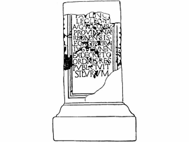
Roman Inscribed Stone. Drawing by R. G. Collingwood (1924)

The Paulinus Stone or The Civitas Silurum Stone: The large block of bath-stone is a statue base with a dedication to: Tiberius Claudius Paulinus, a commandant of the second Augustan legion about 214-17 AD. After this he held office in two Gallic provinces. In 220 he returned as Governor of Brittania Inferior (Britain had been divided into two provinces: inferior and superior at the beginning of the 3rd century by the Emperor Septimus Severus). As the inscription does not include this latter information the stone, which is a statue base (pedestal), probably predates this. Of singular importance, however, is the reference to the local civil administration: it tells us that the Silures were administered by a council. The dedication reads:-

To (Tiberius Claudius) Paulinus (once) commander of the second Augustan legion (next) proconsul of the province Gallia Narbonensis (now) Imperial Governor province of Lugdunensis by decree of the council of the community of the state of the Silures.                                                                                                                                                                                                 

The stone was found in 1903 having been re-used as part of a post-Roman construction of blocks in the centre of the village on which the war memorial now stands. It can now be seen just inside the church porch.
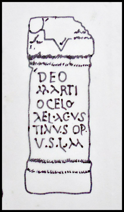
Roman altar stone.

Altar Stone.

A second Roman antiquity which also stands in the church porch is a stone made of yellow sandstone. This is an altar-stone dedicated to the god Mars (Ocelus). The inscription reads:-

To the God — Mars (Ocelus) — Aelius Augustinus — optio (a junior officer) — Paid his vow willingly and duly.


Caerwent’s earliest mention post-Rome and Medieval is in the works of John Leland (1540) by which time most of the internal buildings had been robbed out to create cottages and the church. In the late 18th and early 19th century the first tourists arrived leaving their impressions—the worst aspect of which, from our point of view, is that what was left of the limestone was being burned for lime!

Octavious Morgan was the first to conduct an archaeological dig in 1855 revealing a small bath-house together with another building in insulae XX. The extant ground plan of the town emerged during further excavations between 1899 and 1913 by the Clifton Antiquarian Club, funded by Lord Tredegar. Finds from this dig, which exposed 2/3% of the town, are now in the Newport Museum. Further digs in 1923 revealed the Public Bath House; in 1925 the walls on the SE side were excavated, while in 1946-7 the Pound Lane Shops and courtyard house; in 1973 the town cemetery outside the East Gate; in 1981 a large courtyard house in the NW corner, and then in 1992 the Forum Basilica was excavated.

Newport Museum and Art Gallery: The museum in John Frost Square is open Tuesday to Friday 9.30am to 5 pm, and Saturday 9.30 to 4pm. Entry is free. The museum houses many of the artefacts found at Caerwent over the years: a 2nd century broach in the form of a hare, a fragment of a painted wall depicting a girl’s face found in 1901, a statue of the mother goddess found near the temple precinct in 1908, a number of mosaic floors including the one found in the mansion, roof finials in the form of a lantern, a pine cone, locks and keys, a pewter bowl scratched with the Christian Chi Ro monogram, pots, coins and agricultural equipment. Other artefacts are housed in the National Museum of Wales, Cardiff.

Sources and other related websites:-

Barber, Chris, More Mysterious Wales, Paladin, London, 1987.

BBC Publication, Roman Britain, The British Broadcasting Corporation, London, 1966.

Brewer, Richard J., Caerwent Roman Town, Cadw Welsh Historic Monuments, 1993.

Evans, J. Barrie, The Parish Church Of St. Stephen & St. Tathan Caerwent – A Short Guide.

Spencer, Ray, A Guide to the Saints Of Wales and the West Country, Llanerch Enterprises, Felinfach, Lampeter, Dyfed, 1991.

Wilson, J. A., A Guide to the Roman Remains in Britain, 4th Edition, Constable, 2002.

https://romaninscriptionsofbritain.org/inscriptions/311

https://romaninscriptionsofbritain.org/about/terms-of-use

https://en.wikipedia.org/wiki/Caerwent

https://en.wikipedia.org/wiki/Caerwenthttps://en.wikipedia.org/wiki/Venta_Silurum

http://maryinmonmouth.blogspot.co.uk/2008/10/in-steps-oif-st-tatheus-of-caerwent.html

http://cadw.gov.wales/daysout/caerwent-roman-town/?lang=enhttps://museum.wales/1493/

https://museum.wales/1493/

                                                      © Ray Spencer, The Journal Of Antiquities, 2017.