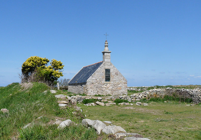
St Corentin’s Chapel on I’le de Sein, by Ji-Elle (Wikimedia Commons)
Latitude: 48.041993. Longitude: -4.867500. At the far northwestern side of the I’le de Sein at the sacred place called Goulénez, just 8 kms off the Finistere Coast at Pointe de Raz, (Bretagne) Brittany, stands the restored chapel dedicated to St Corentin (Cury), a 5th century Celtic saint who became bishop of Quimper; he was apparently also the adviser and confessor of King Gradlon le Grand – whose Breton kindom of Caer Ys (or Is) was both legendary and almost certainly, mythical. Quimper eventually being the location of his new royal palace. The lonely little chapel, of ancient origins but restored in the early 1970s, is a short distance from the rocky seashore of the island’s northwest coast. There is also a holy well/spring and close to that is the ‘Hermit’s Garden’. St Corentin’s Chapel and holy well have long been a place of pilgrimage and veneration for the islanders themselves, but further back into the mists of time the island was home to the druidic priestess, Velleda, and then the Romans probably camped on the island, which ‘they’ were to call: Insula Sena. To reach the site: follow the Route du Phare coastal path around the north and northwest side of the island.
The Insight Guide (1994), says of the island: “Bretons call Ile de Sein Enez Sun, and it is suggested that this helps to identify it as the Isle of the Dead, a burial place of the druids. It is also said to be the Romans’ Insula Sena, a mysterious island where sailors used to consult an oracle tended by nine priestesses.”
The Insight Guide (1994) adds: “The home of King Gradlon, Is, was protected by a dyke and the key to its gates was always carried by the king. His daughter, named variously as Dahut or Ahés, had become attracted by the Devil in the shape of a handsome young man. The Devil requested that she steal the key to the gates that protected a dyke surrounding the king’s palace at Is. At the Devil’s request she stole the key and opened the gates allowing the sea to pour into the city. King Gradlon managed to escape on his horse with his daughter clinging onto him for dear life, but a voice from heaven informed him that he could only be saved if he ditch this evil spirit. He did this, and the sea withdrew, but his kingdom of Is was completely submerged and destroyed.
“The king then chose Quimper as his new capital for the kingdom of Cornouaille, and his statue stands between the two towers of the cathedral. For the rest of his days, he lived a life of holiness and piety, helped by the first bishop of Cornouaille, St Corentin. As for his daughter, Dahut, she became a mermaid (siren) known as Marie-Morgane, and today still lures sailors to watery graves,” according to the Legend.
The Insight Guide (1994) goes on to say that “As for St Corentin, he is remembered for his diet, which consisted purely of the flesh of one miraculous fish. Each day he would eat half of the fish and throw the rest back into the river, only to find it restored to full size the following day. Corentin was one of the first Celtic religious leaders to move to Brittany in the 5th century and, like the others, he became a saint.”
David Hugh Farmer (1982), says of St Corentin that he was: “Cornish founder and patron of Cury in the Lizard. He was a Celtic hermit who later became a Bishop in Brittany. An ancient cross stands near his church; in 1890 a fresco was discovered in Breage (the mother-church of the Lizard), which depicts him in cope and mitre with a pastoral staff. Beside him is a fish, from which he was reputed to have cut and eaten one slice each day, without any diminution in the size of the fish. An ancient Breton cult in his honour was revived by a private revelation in the 17th century, when several old shrines there were restored. His feast (translation?) at Quimper is the occasion for presents of blessed cakes. Ancient feast: 1st May.”
Map of I’le de Sein (North)
St Corentin or Corentinus, was a native of Armorica (Brittany), but he may have visited the southwest of England and maybe Wales at some point. At least one church is dedicated to him at Cury in Cornwall, where he is called St Cury. However, he was more likely a hermit living on the I’le de Sein (440 AD), a small island in the Atlantic, just off the Finistere coast, and later at Plomodiérn near Ménéz-Hom in Crozon. St Guenole (Winwaloe) was his disciple. Indeed, St Guenole also has a church dedication on the island. Corentin established a hermitage and church on the island and imparted his holiness into the waters of a well there. The site being of pre-historic importance. A modern wood statue of the saint stands inside the tiny chapel along with one of the Virgin Mary, and other Breton saints. Eventually, King Gradlon installed Corentin as first bishop of Quimper, in Cornouaille; the Cathedral of St Corentin now stands on the site of his church. He died at Quimper in 460, 490 or 495 AD. His feast-days are 1st May (translation) and 12th December.
Henry Queffélec (1945 & 1972), says of St Corentin’s hermitage on I’le de Sein: “the Chardin an Iarmit, or “‘Hermit’s Garden”‘, was situated on the western end of the ile de Sein next to a small chapel dedicated to St Corentin. Although the chapel has now fallen into ruins the site is still regarded by the people of Sein as a place of pilgrimage and special veneration. Cambray in his Voyage dans le Finistère of 1794 described the chapel and garden.”
Queffélec adds that: “There is no evidence whatsoever that the chapel dedicated to St Corentin was ever destroyed by fire or that its stones were used to build another church on the island. This chapel, unfortunately, has simply been allowed to fall into ruins and very little remains of it today.” [The chapel was, however, rebuilt in 1971 by the people of the island and the priest.]
He also adds more information with regard to the History of the island, saying that: “In early times, the ile de Sein was thought to be the haunt of supernatural beings. In the first recorded mention of the island in 43 A.D, in the work of the Roman geographer, Pomponius Mela, we are told that the Insula Sena possessed an oracle which was served by nine vestal virgins who had the capacity to control the elements and cure the apparently incurable. This tradition is later exploited by Chateaubriand in Book IX of Les Martyrs (1809) in his description of the sacrificial activities of the Celtic druidess Velleda some of which take place on the “‘ile de Sayne, ile venerable et sacrée”‘. In the Middle Ages , the ile de Sein is caught up in the Arthurian legends and according to some storytellers, is the birthplace of two of the most accomplished magicians, the wizard Merlin, and Morgan La Fée.”
Sources and related websites:
Insight Guide, Brittany, (Ed. by Brian Bell), APA Publications (HK) Ltd., 1994.
Farmer, David Hugh, The Oxford Dictionary of Saints, Oxford University Press, 1982.
Queffélec, Henri, Un Recteur De L’ile De Sein, George G. Harrap & Co. Ltd., London, 1972. Originally pub. in French Language (1945) by Éditions Stock.
https://commons.wikimedia.org/wiki/Ile_de_Sein
https://en.wikipedia.org/wiki/Corentin_of_Quimper
https://en.wikipedia.org/wiki/%C3%8Ele_de_Sein
La chapelle St Corentin
https://www.breizh-poellrezh.eu/bretagne/%C3%AEle-de-sein/
http://www.earlybritishkingdoms.com/bios/gradlmby.html
© Ray Spencer, The Journal Of Antiquities, 2018.