View of Roman fort at Caer Llugwy by Peter Mitchell. (Wikimedia Commons).
NGR: SH 74583 57237. On a flat area of grassy land beside the Afon Llugwy and surrounded by woodland at the west and eastern sides are the almost rectangular earthworks of Caer Llugwy Roman fort. It was a minor posting fort – the site of which is now on private land a few miles east of Capel Curig – in the Conwy district of North Wales. The nearly 4 acre earthworks of this Roman fort lie just southeast of the A5 road in the Llugwy Valley; and it is also called Bryn-y-Gefeiliau, taking its name from a nearby farm. It dates from 90 AD when it was built of earth and wood, but was extended on the E side, and built of stone around 120 AD whereas the western part was then annexed. This western section had a mansio-type building, which was like a lodging house or country hotel! There were excavations at the site back in 1861 and between 1920-22 but the fort was first recognized as such in the mid 17th Century by Lhuyd. To reach the site head west out of Betws-y-Coed on the A5 for a couple of miles until just before Pont-y-Pair Bridge where you turn left onto a lane for ½ a mile – the Roman fort (site) is on the right-hand side opposite Cae Awr woods. The earthworks are on private land.
The Roman military machine marched into the Llugwy Valley towards the end of the 1st century AD in order to consolidate their hold on the north of Wales, in particular the Conwy Valley, and to build a small fort on level ground beside the river Llugwy (the course of which might have been different at that time). The first fort they built in 90 AD was of earth, turf and wood, and was at the western side of this flat area of land just where the river takes a large loop around; then in about 120 AD they added a second, smaller section of fort on the east side of the earlier section, which was built of stone; the western section was then annexed and a mansio with a courtyard built; the foundations of this building still stand 3 feet in height in the clump of trees. Roman auxiliaries would have built the fort. The fort and its annex were surrounded by an almost square-shaped defensive stone rampart and double ditch, which were rounded at the corners as was the norm for Roman forts. It’s sad that much of the stone-work has been robbed-away to build walls and farm buildings in the local area, and now only foundations remain of the mansio building. Caer Llugwy Roman fort is a ‘scheduled’ ancient monument.
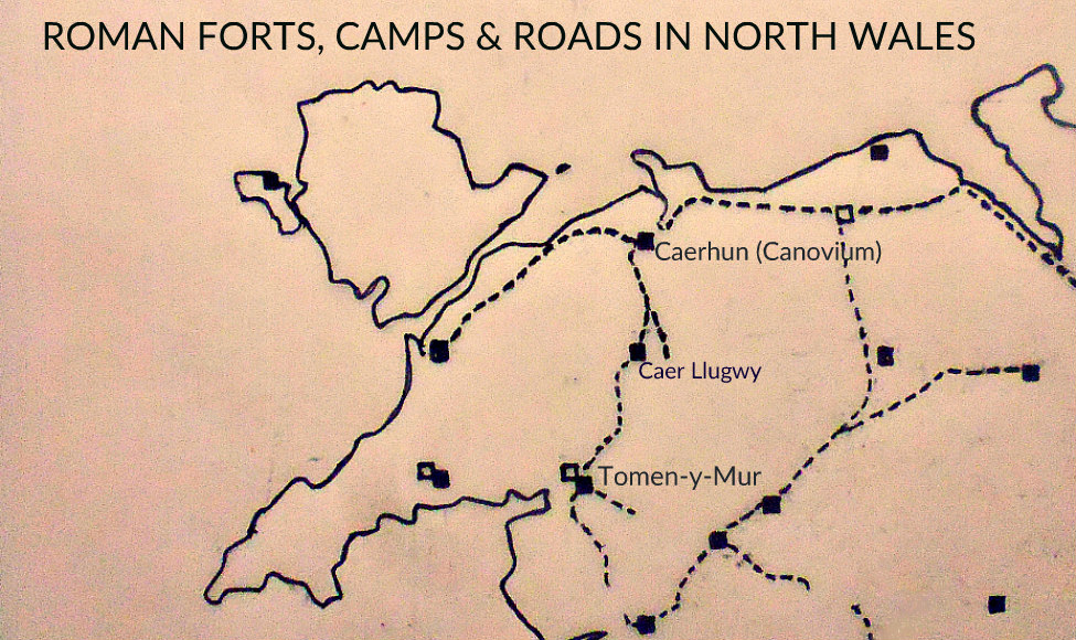
Map showing Roman forts, camps and roads in North Wales.
A cohort of 500 auxiliary soldiers would have been stationed here by the early to mid 2nd Century AD. However, around 155-158 AD the fort beside the river had been abandoned and the soldiers sent to the north, probably to help strengthen and guard Hadrian’s Wall, or the Anto-nine Wall, or some other outpost. Or was the Llugwy Valley and the surrounding high ground to inhospitable? The “presumed” Roman road north from Tomen-y-Mur to Caer Llugwy and then north to Caerhun (CANOVIUM) would be extremely difficult in bad weather; and to compound this – the Ordovices tribe were still a major irritation to the Romans in the north-west of Wales. It would seem, however, the fort may have been re-occupied in some way during the 3rd and 4th Centuries AD.
There was a mansio at Caer Llugwy Roman fort. The word ‘Mansio’ comes from the Latin ‘mansus’ meaning a place to stay for rest and refreshment. A Mansio was an official stopping place on a Roman road maintained by the government for the use of officials and those on official business. It was essentially an Inn. The Mansio structure was similar to that of a standard villa design built with three wings arranged around a courtyard, but more specific with rooms for the traveller, stables for horses, and often a small bathhouse and a latrine. There may have been underground heating systems (hypocaust) built into these buildings, making for an almost cosy place to stay! Caer Llugwy had one!
It is widely known that the Romans were mining for metals in the north of Wales. The copper mines were certainly being exploited by them and also gold and lead were being dug; and we also know they were looking for pearls in the river beds, especially the Afon Conwy! The fort at Caer Llugwy was almost certainly used as a base/station for these mining operations, which is borne-out by the name Bryn-y-Gefeiliau – Hill of the Smithies.
Christopher Houlder (1978) says: “The Roman road from Caerhun ……..southwards kept mainly to the hills, but where it dipped across the Llugwy valley at Bryn y Gefeilau (746 572) a minor fort was set up in the I century, possibly as a mining station.”
Michael Senior (1984) tells us: “The Romans Arrive: They launched their first attack into North Wales under the leadership of Suetonius Paulinus, from the legionary headquarters at Chester, in the year 61 A.D. It is likely that the road across the hills originates from that expedition, and that a small field fort would have been established in the valley. Their purpose was to invade and subdue the island of Anglesey, which, Tacitus tells us, “was feeding the native resistance”. This first invasion however met with failure. With the Roman general and a large part of the army so far away, the Britons of the south-east, under their famous queen Boudicca, took the opportunity to revolt. Suetonius had hardly reached Anglesey when the news came, and the army in Wales had to withdraw at once and set out on that effective system of routes on the long march south.
“It is probable that the more substantial fort (Caerhun) at the river crossing dates from the second, more extended campaign. In the late summer of A.D. 77 he tribe whose territory was North Wales, known to the Romans as the Ordovices, ambushed and massacred, somewhere near our area, an outpost of Roman cavalry. This was a serious blow to Roman morale, and demanded action.
“The new Roman governor of Britain, Agricola, took the courageous decision of marching into North Wales late in the year, risking a winter campaign in the mountains. He pursued the Ordovices, perhaps taken off-guard, into their strongholds, and to ‘cut to pieces’, Tacitus says ‘almost the whole fighting force of the nation.’ To consolidate this victory he decided to carry through the earlier abortive attempt to occupy Anglesey. One of the key elements in a strategy involving moving men between Chester and Anglesey was the protection of the crossing of the Conwy river, particularly as this point could also be supplied by sea. The crossing place which the Romans chose was a little upstream of later ferries and bridges, and would no doubt have been the junction of the lowest possible fording point with the highest navigable tidal water at that time. It lies at Caerhun, near to the present church and hall of that name (776703).”
Mr Senior (1984) goes on to say that: “Part of the explanation for this Roman presence on the bank of the Conwy may possibly be the importance to Rome of British pearls. A Latin historian records that Julius Caesar himself was impressed by their size. It is known that Conwy’s pearl industry, which took place up the river until modern times, was extremely ancient. The pearls grew in the large fresh-water ‘horse-mussels’, which some people claim may still be found in the Trefriw area. Whatever the reason for their coming and remaining, there is no doubt that the effect of it was to put North Wales on the map. The existence of that road set the pattern for future communications, and facilitated movement into and out of the area from then on. The existence of that Roman community at Caerhun gave an impetus to a settlement pattern within the valley, and no doubt stimulated activity which helped to stir the valley from its long sleep.”
Sources / References & Related Websites:-
Houlder, Christopher, Wales: An Archaeological Guide — the prehistoric, Roman and early medieval field monuments, Faber And Faber, London, 1978.
Senior, Michael, The Conwy Valley — Its Long History, Gwasg Carreg Gwalch, Capel Garmon, Llanrwst, 1984.
The BBC, Roman Britain, The British Broadcasting Corporation, London, 1966.
https://en.wikipedia.org/wiki/Caer_Llugwy
https://coflein.gov.uk/en/site/95274/details/caer-llugwy-bryn-y-gefeiliau-roman-site
Check out this Link: http://ardal-wales.co.uk/english/local-history/roman-period/
Link to Cadw: https://cadw.gov.wales/sites/default/files/2019-04/InterpplanRomanConquestofWales_EN.pdf
https://ancientmonuments.uk/128314-bryn-y-gefeiliau-roman-site-capel-curig#.XxnJW1LsZjo
https://www.romanobritain.org/4-celt/clb_tribe_ordovices.php
Copyright © Ray Spencer, The Journal of Antiquities, 2020.