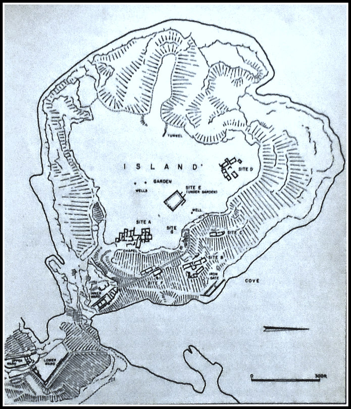
Map of Tintagel Island in Cornwall.
OS Grid Reference: SX 05003 89064. On the rocky, windlashed headland of Tintagel-Head, in Cornwall, near the ruins of Tintagel Castle which was built in c 1145, are the scant foundations of what was considered to be a Celtic monastery, dating from the beginning of the 6th century AD. This was probably a high-status Dark Age monastery with royal connections. There are also the walls of a 12th-century chapel of St Julitta which is attached to the monastic buildings. It has always been assumed that the monastery here on Tintagel Head was founded in 500 AD by St Juliot, Julitta, or Julianta, a princess who hailed from south Wales, and might be one and the same as St Uletta. Tintagel Castle has long had “romantic” associations with King Arthur and Merlin the Magician. Today the monastic remains lie on Tintagel Island, which is all but cut-off from the rest of the headland where the castle ruins are situated. There is limited access from the castle to Tintagel Island through a deep chasm in the headlands via a footpath and bridge, but its very precarious and great care “should” be taken, especially if weather conditions are against you.
The monastic site here at the south side of Tintagel Island, with its rectangular-shaped buildings all joined together, was excavated in the 1920s and 30s by C. A. Raleagh Radford (1900-1999) – at which time it was thought to be a high status Celtic monastery, but more recently a few historians have opted for the possibility that it might have been a trading centre due, perhaps, to the large amounts of pottery (known as Tintagel Pottery) found at the site, says Geoffrey Ashe ‘A Guidebook to Arthurian Britain’. Another large building (site E) that was a part of the monastery lies beneath a garden, while other little clusters of buildings (sites B.C. and F) lie to the S and SE of the main monastic site, which is known as site A. These clusters of buildings were probably the monastery’s farm and stables. By the 9th century it seems the monastery here at Tintagel was abandoned, its buildings left to go back to nature and the mists of time, but to be re-invigorated again in the 1920s by an archaeological dig!
There is a lot of very good field information on the Celtic monastery at Tintagel in the work ‘The Quest for Arthur’s Britain’, edited by Geoffrey Ash. It says that with regard to excavations on the island: “These excavations showed that the headland of Tintagel had been the site of an extensive Celtic monastery. Four different phases identified in one of the buildings indicated a long period of occupation. Imported pottery from the east Mediterranean established an initial date in the fifth or early sixth century. A silver penny of King Alfred (871-99)—the latest artifact antedating the castle—may represent no more than the loss by a pilgrim to a deserted oratory which was no longer the centre of a living community. Pottery of the twelfth century and later, though relatively common on this site, was never found in the layers associated with the monastery.
“The Celtic monastery of Tintagel was bounded on the landward side by an earthen bank, now crowned by the thirteenth-century curtain, and by a broad, flat-bottomed ditch. The upper part of the existing bank is a twelfth-century heightening, but the base, some 30 feet across and 8 feet high, dates from the fifth or sixth century. Like its medieval successor, the monastic bank ran from the edge of the scarp overlooking the eastern valley to within a short distance of the protruding boss of rock, leaving the same narrow entry. Early texts often speak of the monastic vallum, a term indicating the enclosure which fenced in the cashel or settlement occupied by the community. It seems always to have been a physical barrier, an earthen bank, a rampart of turf or a hedge. But it also had a spiritual meaning, separating the city of God from the world outside.
“Within the enclosure the monastery consisted of groups of buildings, each with its special function. Eight such groups were located, of which six were explored and planned; the other two had been too far destroyed by the medieval castle. Two further sites were noted in folds of the cliff, and others probably await identification.
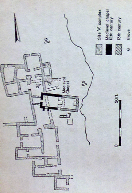
Plan of Celtic monastery at Tintagel, Cornwall.
“The first and largest site examined lay on the eastern edge of the plateau; it was centred on the twelfth-century chapel. The Celtic site consisted of a long range of buildings facing east on to a court which was bounded on the far side by the cliff, here forming the edge of the plateau. The range was approached from the south by a path running along the edge of the plateau; this is now reached by a modern zigzag approach rising up from the inner ward of the castle. The original way is likely to have been along the plateau, which has here been destroyed by the encroachment of the sea. At the south end of the range of buildings, a small square room thrust forward from the general line, together with the stub of a wall, suggest a gate with a lodge providing access to the court. With the court, a much-ruined stretch of walling immediately south of the later chapel is probably part of an older oratory. Beside it is the base of a square block of masonry, a tomb shrine or leacht. These tomb shrines are a normal feature in Celtic cemeteries; they housed the relics of saints or founders.
“On the far side of the chapel a number of graves have been discovered. The oratory with the tomb of the saint would be the primary objective of visiting pilgrims. In its immediate vicinity one would expect to find the various buildings catering for their needs. There would be a treasury containing other relics, perhaps possessions of the saint. There would also be a sacristy, where the vessels needed for the service of the oratory would be stored. A guesthouse for the refreshment of pilgrims might also be found in this area, together with rooms needed by those members of the community charged with the care both of the pilgrims and of the lay community, of which the pastoral care was the responsibility of the monastery.
“On this basis, it may tentatively be suggested that the southern end of the range, with a large central hall and smaller rooms grouped on one side and to the back, represents the guesthouse. The central part, now appearing as a single room, has been much damaged by the later chapel. Originally it may well have been subdivided, and here, in the vicinity of the oratory, one might expect the treasury and sacristy. This would leave the smaller rooms at the north end for the needs of those members of the community whose duties were with the lay world. This range had a long history. Four distinct building phases could be recognized. Normally the phases indicated adaption, while retaining the main structure of older date. Even so, a life of some three centuries is not likely to be too long for the existence of this community, and it could well have been in being for a far longer period.”
And what about the founder/foundress of the Celtic monastery on Tintagel Head. Who was St Juliot or Julitta? The thinking is that the founder was St Uletta (Ilid). She was, according to legend, one of the many daughters of King Brychan Brycheaniog and was the founder of the first church at Llanilid in the Vale of Glamorgan in Wales, and is commemorated there with St Curig. In c 500 AD she went with other members of her family to Cornwall. We know that she was close, spiritually, to her sister St Morwenna and her brother St Nectan. It seems, however, that in Cornwall her original name was St Juliana (Iludiana) and over time the name became Juliot and Julitta; and soon after her arrival in Cornwall she established the monastic community at Tintagel.
But St Juliot has been much confused with an early 4th-century Christian martyr called St Julitta, who was commemorated with her three-year-old son St Cyricus in the west country. Their cultus was brought to Cornwall in the Middle Ages. St Juliot, however, is perhaps the patroness of Luxulyan church, Cornwall, with a feastday on the sunday nearest 29th June, according to David Farmer ‘Oxford Dictionary Of Saints’. In Cornwall St Juliot (Julitta) is sometimes referred to as a “martyr” due to confusion, again, with the 4th-century saint of the same name. St Juliot is also commemorated at Lanteglos-by-Camelford, Cornwall, where a holy well is named for her. And St Juliot in the Valency Valley, north-east Cornwall, is named after the saint. A few historians have suggested that St Juliot was, in fact, a male saint! St Julitta’s feastday at Llanilid church in Mid Glamorgan, Wales, is given as 30th June.
Sources and related websites:
Ashe, Geoffrey, A Guidebook to Arthurian Britain, Longman Group Limited, London, 1980.
Farmer, David, Oxford Dictionary Of Saints, Oxford University Press, 2004.
https://en.wikipedia.org/wiki/Saint_Ilid
https://en.wikipedia.org/wiki/St_Juliot
http://www.thisisnorthcornwall.co.uk/king_arthur.html
Jones, Sally, Legends of Cornwall, Bossiney Books, St Teath, Bodmin, Cornwall, 1980.
Spencer, Ray, A Guide to the Saints Of Wales and the West Country, Llanerch Enterprises, Felinfach, Lampeter, Dyfed, 1991.
The Quest for Arthur’s Britain, (Edited by Geoffrey Ashe), Paladin Frogmore, St Albans, Herts, 1976.
Westwood, Jennifer, Gothick Cornwall, Shire Publications Ltd., Princess Risborough, Bucks, 1992.
© Ray Spencer, The Journal Of Antiquities, 2017.

January 16, 2017 at 3:57 pm
Wonderful material . . . for a very small audience of which I am a member. Fascinating!
LikeLike
January 12, 2017 at 11:36 am
Reblogged this on Lenora's Culture Center and Foray into History.
LikeLike