The Journal Of Antiquities

Ancient Sites In Great Britain & Southern Ireland


Trippet Stones and Stripple Stones, near Blisland, Cornwall.

The Trippet Stone Circle, Bodmin Moor, Cornwall.

NGR: SX 1310 7500  &  SX 1440 7520 respectively. On Manor Common, near Blisland, Corn-wall, are the Trippet or Tripping Stones, which are actually a stone circle of standing and fallen stones. Approximately 1 mile to the northeast, another stone circle, the Stripple Stones, is situated within a henge monument on the south slope of Hawk’s Tor, located on the edge of Bodmin Moor in Cornwall. Both stone circles can be found in direct sight of each other, which would seem not coincidental when the second circle was built, probably in 1700 BC. Both ancient monuments are located some 6 miles northeast of Bodmin, near the A30 road. The Trippet Stone Circle (also known as the Dancing Stones) has a diameter of around 32 metres (105 feet) and is thought to date back to the Bronze Age; and at its centre, a more recent standing stone, whereas the Stripple Stone Circle, which has a recumbent stone at its centre and a few other outer stones, is just over 44 metres (145 feet) in diameter and dates back to the Neolithic period.

James Dyer, writing in 1973, says of Trippet Stones: “This is a small but impressive circle of eight standing, and four fallen, stones, 33 m in diameter. Most of the stones are roughly rectangular blocks, about 1.5 m high. In the centre is a modern boundary stone.”

Plan of Stripple Stone Circle and Henge on Bodmin Moor, Cornwall, from the Wikipedia website.

James Dyer, writing in 1973, says of Stripple Stones that: “On the slope of Hawks Tor is an em-banked enclosure with internal ditch 68.3 m in diameter. Inside it is an irregular circle of fifteen (formerly twenty-eight) granite blocks, only four of which are still standing. Almost in the centre of the stone circle, which is 44.5 m in diameter, is a single recumbent stone, and three others lie outside the circle but within the earthwork. Excavations by H. St. George Gray in 1905 showed that the surrounding ditch was very irregular, but averaged 2.7 m wide and 1.2 m deep. It was broken by an entrance facing south-west towards the Trippet Stones. The stones themselves were in shallow holes, none more than 0.8 m deep. The site is clearly a henge monument by the position of its internal ditch. The presence of the stones suggests a continuity between the Neolithic henge and Bronze Age stone circle. Modern excavation might reveal that the earthwork is older than the stone setting.” 

John Michell, writing in 2003, says of both the Stripple Stone Circle and the Trippet Stone Circle and the surrounding area: “The Stripple Stones and the Trippet Stones. These two circles stand within a mile of each other on Bodmin Moor below Rough Tor. They were evidently connected, for they are inter-visible and the entrance to the first circle is orientated towards the second. The Stripple Stones are unique in Cornwall, being the only henge circle. The surrounding earthwork has its ditch inside, proving its ritual rather than defensive function. Most of its stones, including the central are now fallen. In the same district are the Leaze Circle to the north-west and, on the east side of the moor, the small and attractive Nine Stones Circle at Altarnen. The Fernacre circle is one of the largest on Bodmin Moor, up to 150 ft across. Its siting is spectacular, with views to Rough Tor, Brown Willy and other landmarks. Originally, it consisted of about 90 stones, most of which are now fallen or missing.”

Mr Michell goes on to say that: “Several circles, together with the only Cornish stone row, are called Nine Maidens, and are supposed to have nineteen stones, representing a lunar cycle. The other common legend is that the stones are petrified dancers or musicians. That was their punishment for dancing and playing on the Sabbath. Near St Buryan in the far west, the Merry Maidens circle, which the old Cornish named the Dancing Stones, was said to represent unauthorised merry-makers who were turned to stone. The same legend is in the name of the Trippet (tripping or dancing) stones on Bodmin Moor.”

Sources & References & Related Websites:-

Dyer, James,  An Archaeological Guide — Southern England,  Faber, London, 1977.

Michell, John, Prehistoric Sites in Cornwall, Wessex Books, Salisbury, Wiltshire, 2003.

The AA, The Illustrated Road Book of England & Wales, The Automobile Association, London, 1961.

http://www.stone-circles.org.uk/stone/trippet.htm

Wikipedia website: https://en.wikipedia.org/wiki/Stripple_stones https://commons.wikimedia.org/wiki/File:The_Victoria_history_of_the_county_of_Cornwall_(1906)_(14590965339).jpg

https://www.historic-uk.com/HistoryMagazine/DestinationsUK/Bodmin-Moor-Historic-Monuments/

© Copyright, Ray Spencer, 2025.


Fairy Caves (Coking Ovens) Leeds and Liverpool Canal, near Oswaldtwistle, Lancashire.

Old Coking Ovens or kilns beside the Canal near Oswaldtwistle. Photo courtesy of the late Donald Jay.

NGR: SD 7375 2848. An Industrial Heritage and Archaeological site located beside the Leeds and Liverpool Canal near Oswaldtwistle, about halfway between Accrington and Blackburn, Lancashire. Locally known as Fairy Caves, but they are, in fact, coking ovens or kilns, which are still in a reasonably good state of preservation, despite the passage of time. Blackburn Road (A679) runs alongside the canal here, and Church Kirk (St James) can also be seen from here. A wharf (basin) and a short canal arm where the coke and coal were loaded onto barges can still be seen beside the three banks of coke ovens at the northern side of the cut. Nearby is the site of Aspen Colliery, now largely grassed over, although there are some remains still visible, which were all part of the Aspen Valley coal mining complex that opened around 1810 but closed down in 1930, and the associated coking ovens were abandoned at the same time. However, more recently, the more than twenty brick-lined and grass-covered ovens, which resemble conical-shaped beehives, have become ‘a place of exploration and adventure’ for local children who call them “fairy caves”. In 1977, the site was placed on a schedule for preservation and subsequent listing.

Rowland Joynson, writing in 1975, gives some very useful information regarding the Aspen Valley’s ‘fairy caves’. Mr Joynson says that: “Oswaldtwistle Civic Society have had under consideration the question of the future preservation of some old “beehive”coke ovens. They are on the site of the former Aspen Valley Colliery. 

“Most people think of that site as being in Church, but it is actually in Oswaldtwistle, although it is on the border of the area designated for the Church Centre Action Plan.

“Mr Jack Broderick, the secretary of the Hyndburn Local History Society and myself, knowing that the local Civic Society were interested in these remains, decided to go over to Aspen Valley to have a look at the site. The area has become an obvious playground for children, who have no idea of their origin and purpose, not for that matter have many adults. There were some children actually playing there when we arrived, although they quickly disappeared except for one boy. He said the children called them the “fairy caves”— and so indeed that is what they look like to all intents and purposes. There is no doubt whatsoever that children play hide and seek in them, and there are, of course, the inevitable scrawlings on the walls in several places. The small boy who followed us around said it had been more interesting than having been at school. 

“To our surprise, the former coke ovens turn out to have survived in a remarkably good state of preservation. Our feelings were that at the least nothing should be done to destroy them and that if possible they should be protected. Whether they are of great importance to industrial archaeology, it would be for the trained industrial archaeologists at university level for instance, to say, but there are good grounds for believing that they are of some archaeological importance. They are certainly mentioned in Owen Ashmore’s  “Industrial Archaeology of Lancashire”, which is in Accrington Library.”

Mr Joynson goes on to say that: “Coke, it seems, was originally produced by burning coal in heaps in the open air. The coal was carefully piled and sealed over with slack and set alight. About 1760 coke was produced in an oven. Banks of brick-built ovens, fire-brick-lined and igloo-shaped, each about 12 cubic feet capacity with a door and a chimney in the roof, are known as beehive ovens. The process was to fill the oven with coal slack, seal the door with fire clay and then ignite the coal. With a controlled air intake combustion was completed in about 48 hours. Not all the ovens in the bank were coking at the same time. The heat from two out of a bank of eight was directed through a system of intercommunication flues to preheat the other ovens before firing commenced, thus making the most economical use of the heat before it was wasted through the chimney. The end of the 19th century saw the distillation of coal in coal-heated retorts. Crude gas was given off and the residue was coke. Tar and ammonia products were then produced in the purification process of the crude gas.

“Owen Ashmore in his book, says that the beehives were usually grouped in batteries of at least three, and that these were sometimes at the collieries themselves. He then points out that ovens were often built near canals for convenience of transport, and it is in this connection that he mentions the ovens on the Leeds and Liverpool Canal at Church.

“We counted two banks of ovens with 17 in each. Some are in a better state of preservation than others. Beyond, there is a smaller site of seemingly four or five ovens. These are in an excellent state of preservation and the glazing of the brickwork caused by the intense heat of the oven is well preserved. Here also there is an interesting tunnel which was apparently the ventilation shaft which carried the heat from one oven to another. The brickwork inside looks quite polished, and it would not be surprising if children wriggle through it. It looks an open invitation to something of that kind.” Nevertheless, walking on top of the ovens is not without its dangers. There are holes in the turf where the chimneys have formerly penetrated. At one place there is a fairly large square hole which seems to have been the base for a fairly large chimney to serve the whole battery.”

Mr Joynson adds to the above. He tells us that:“At Aspen there is an inlet from the canal near the former colliery which would allow for the loading of coke onto canal barges.” This basin may have been partially filled in. Miss W. Hogan, the Secretary of Oswaldtwistle Civic Society, tells me that she thinks it has been partly filled in at some time by British Waterways. Whether this is so or not, the site is very weed-grown, marshy and choked with rushes. How deep the mud is goodness knows. But one would imagine it might be dangerous if a child penetrated into it. The wooden bridge over the entrance to the former quay looks very frail. I walked across it gingerly when I went along the embankment last Summer, but on this last visit we did not venture to cross, nor did some people who came walking along the embankment during the afternoon. They preferred to walk around the weed-grown former quay.”

And finally, Mr Joynson tells us more about the former Aspen Colliery: “The former [Aspen] colliery shaft looks as if it may have been filled in either wholly or partially. There is certainly a pile of rubble on the top, but there is a firm fence round it with a newly-posted notice, “Danger, keep out”. The site, Miss Hogan tells me, is owned by Hyndburn Council, but there is a small electricity substation nearby. One has to admit to having spent a most fascinating afternoon wandering about [the] site. The old flywheel mounting of the colliery is still in existence and some of the bricks lying about bore the inscription “St John’s Colliery”. According to Mr. David Hogg’s “History of Church and Oswaldtwistle”,  Aspen pit was sunk in 1869, Rhoden in 1889 and Town Bent in 1892. All this followed the closing of pits on the uplands where the accessible seams were exhausted, Bank Moor and Belthorn having closed in 1853. In 1909 water from the old workings at Bank Moor burst through and eventually flooded Aspen Mine. One boy was killed and 21 trapped underground for some time. Miss Hogan, however, tells me that she understands the colliery remained in existence until 1920, when it was closed because of flooding. I myself seem to have some recollection of seeing the old pit cage there when passing on the railway nearby.”

Richard Peace, writing in 1997, gives directions for the coke ovens: Access: Just off the A679 running north of Oswaldtwistle, wedged between the Leeds-Liverpool Canal and the railway line. Cross over the canal by the bridge at map ref: SD 734284.”

Sources & References:-

Joynson, Rowland,  Join Joynson, Clough & Son, Great Harwood, Lancs, England, 1975.

Peace, Richard, The Curiosities of England – LANCASHIRE CURIOSITIES, The Dovecote Press Ltd., Stanbridge, Wimborne, Dorset, 1997.

Welsh, Mary, Walks from the LEEDS-LIVERPOOL CANAL, Cicerone Press, Milnthorpe, Cumbria, 1996.

https://historicengland.org.uk/listing/the-list/list-entry/1016943

https://en.wikipedia.org/wiki/Aspden

More info here: https://digspag.org.uk/aspen-coke-ovens-walk/.

https://archaeologydataservice.ac.uk/archsearch/record.xhtml

Copyright © Ray Spencer, The Journal of Antiquities, 2025.


St Winifred’s Well, Holywell, Flintshire (Sir y Fflint), Wales.

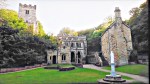
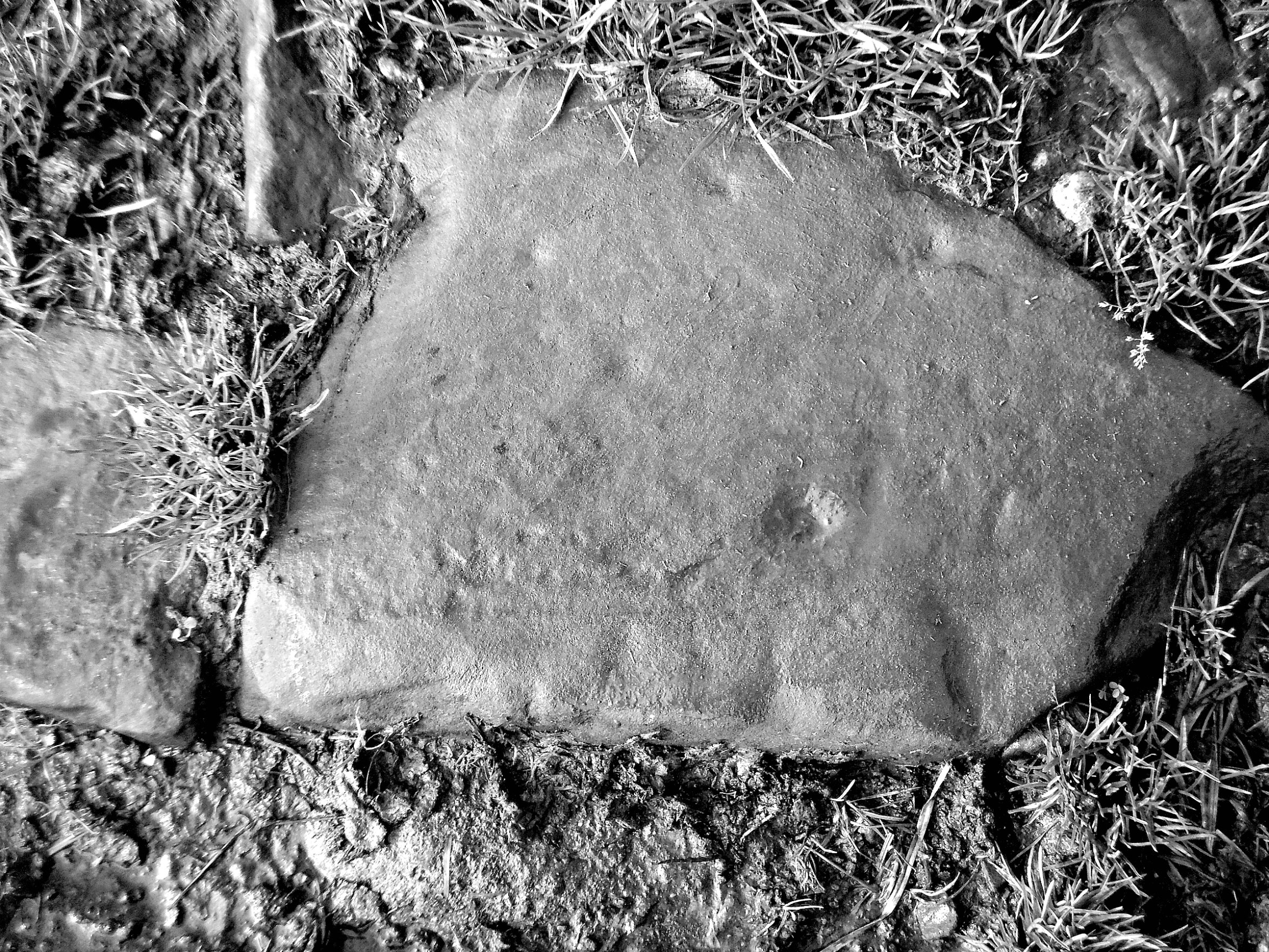
Saint Winifred’s Well at Holywell, North Wales.

NGR: SJ 1854 7634. St Winifred’s Well (Ffynnon Gwenffrewi), a Roman Catholic and Orthodox shrine and pilgrimage centre is located on Greenfield Street in Holywell (Treffynnon), Flintshire (Sir y Fflint), North Wales. St Winifred was the daughter of Thenith ap Eylud and Gwenlo of Tegeingl. Legend says that in the early 7th century AD a spring of clear healing water gushed forth where St Winifred (Gwenfrewy) was martyred after she rejected the advances of Prince Caradoc ap Alyn of Penarlag (Hawarden), after which she was restored to life by her uncle, St Beuno. Sometime later Thenith and St Beuno sent Winifred to Gwytherin on the river Cledwin near Conway, to be educated by St Elerius, her cousin, and where eventually she would succeed St Theonia, mother of St Elerius, to become abbess of a nunnery. Many miraculous cures have taken place at the well, all of which have been ascribed to the healing water which still gushes forth from deep underground. Crutches were left behind at the well after pilgrims were healed of their infirmities. St Winifred was said to have died at Gwytherin in 650 and to have been buried in the churchyard there. St Winifred’s feast day is held on the 3rd of November. The relics of St Winifred were translated to Shrewsbury Abbey in the 12th century, but a fingerbone was given to a Roman Catholic convent in Holywell.

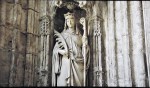
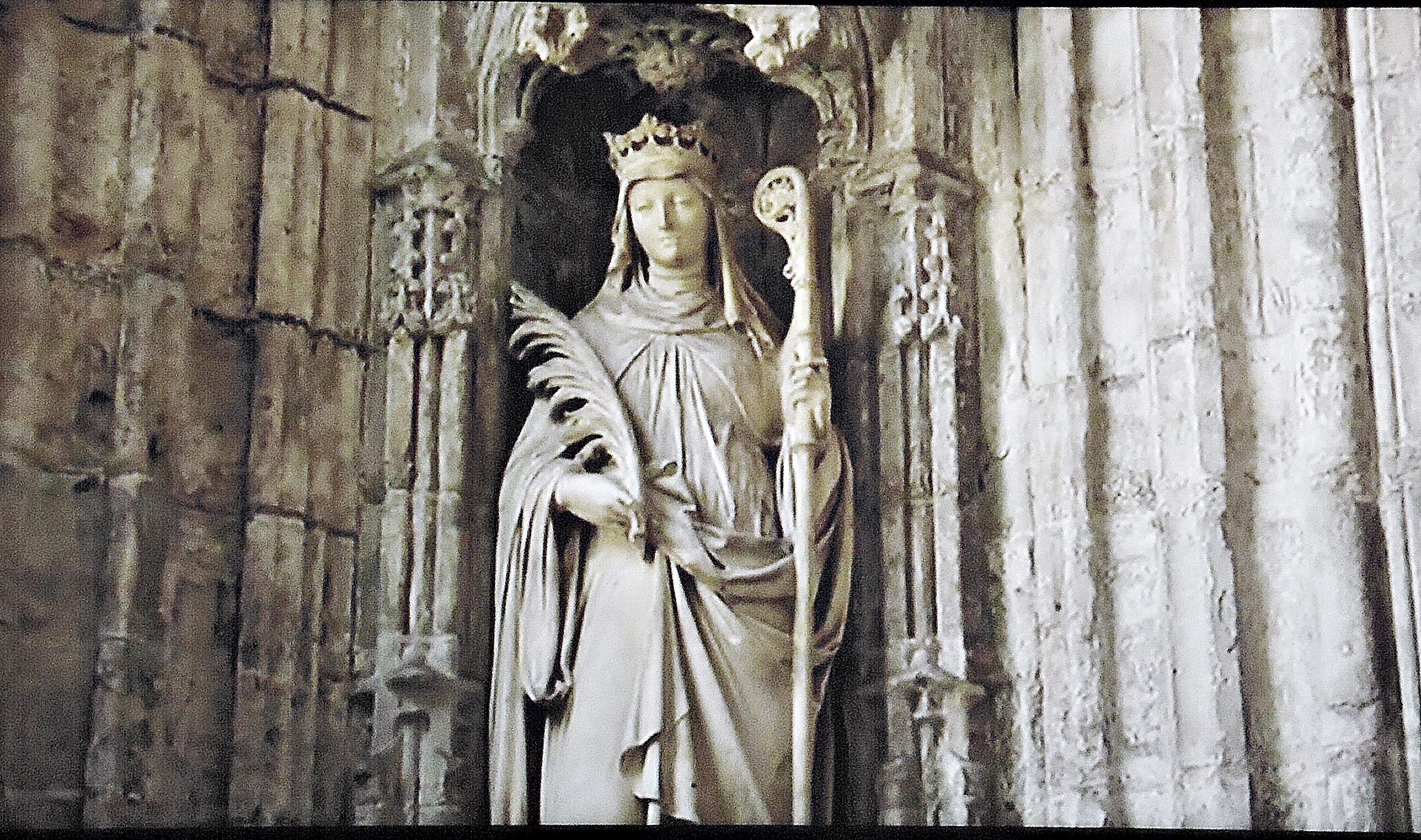
Statue of St Winifred at St Winifred’s Holy Well

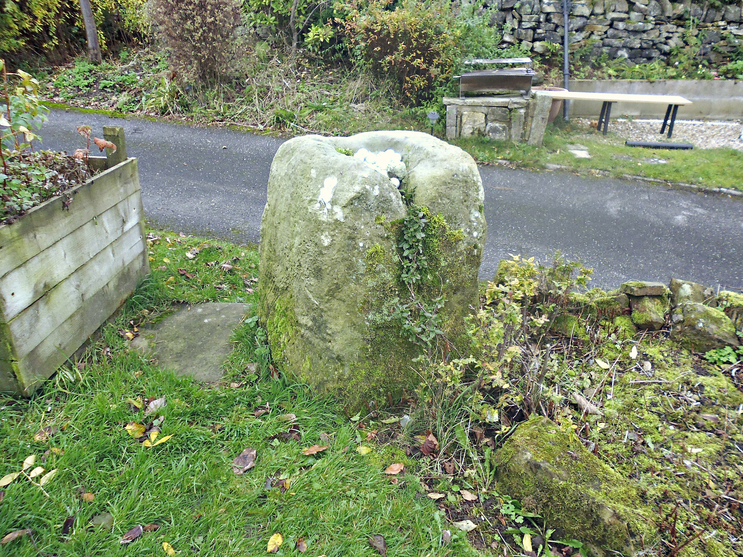
The holy well of St Winifred first became a place of pilgrimage in the 12th century, while the Perpendicular (Gothic) building and star-shaped well chamber with its vaulted ceiling and carvings on bosses dates back to the late 15th century. Depicted on the carved bosses on the fan-vaulted ceiling are St Beuno, Earl Stanley and Lady Margaret Beaufort along with other more comical figure carvings. The chapel that stands above the well was built by a royal beneficiary, Lady Margaret Beaufort, Countess of Richmond and Derby and mother of King Henry VII between 1486-1500. The saintly Lady Margaret (1443-1509) also built three other churches in northeast Wales. There is a very fine life-size statue of St Winifred at one side of the well building; she is depicted with a crown of martyrdom on her head and holding a palm branch in one hand (signifying martyrdom) and an abbesses crozier in her other hand. Today, the holy well is still a pilgrimage centre and shrine, with pilgrims starting their walk here at St Winifred’s Well and traversing the ‘Pilgrims’ Path’ across the rest of North Wales, taking in several other churches and holy wells, which are associated with the Welsh saints: Beuno, Celynnen, Cybi and Digain – amongst others.

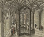
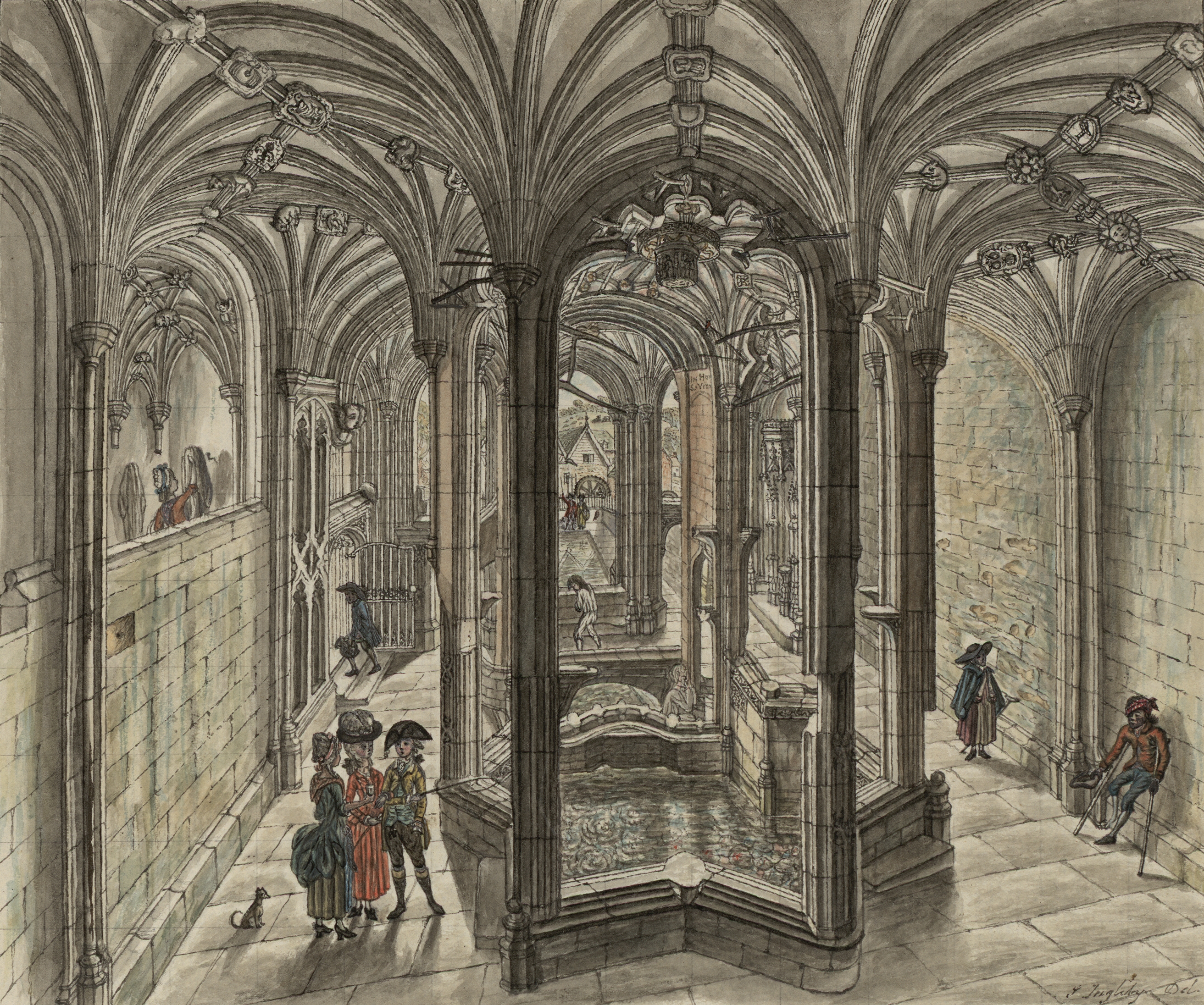
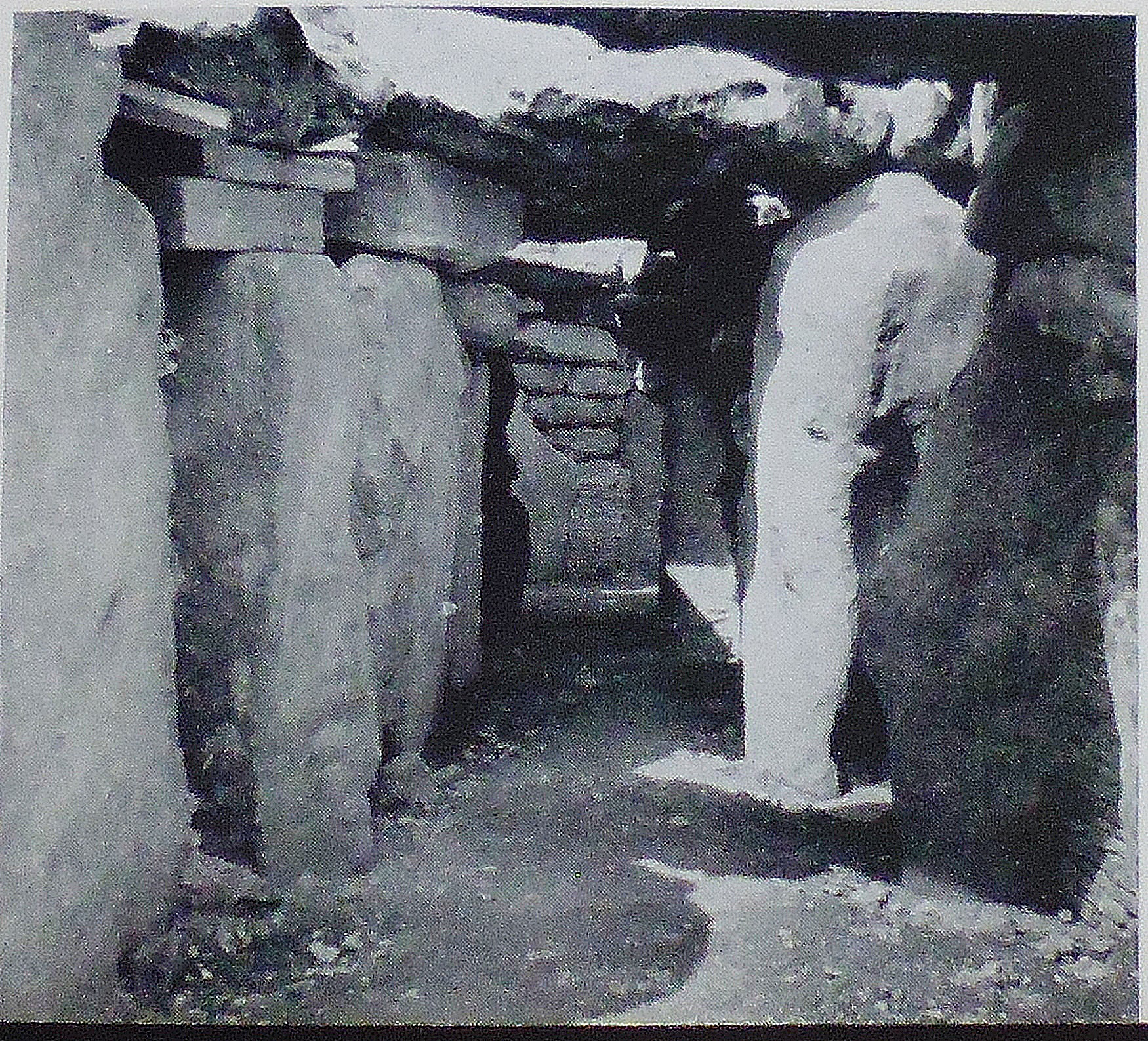
St Winifred’s Well crypt by J. Ingleby (Creative Commons).

Robin Melrose writing in 2016 tells us about St Winifred of Holywell. He says that:- “Wales’ most famous female was undoubtedly Gwenfrewi, better known as Winifred and associated with Holywell in Flintshire, northeast Wales. According to the 14th-century Life of St Beuno, which draws on material from Robert of Shrewsbury’s 12th-century life of St Winifred, Winifred was the only child of noble parents, and a virgin. One Sunday, whilst her parents were at church, the local ruler Caradog tried to rape her. Escaping, Winifred fled towards Beuno’s church: As she reached she reached the door of the church, he caught her up and struck off her head with his sword, which fell into the church while her body remained outside. Beuno and her mother and father saw what had happened, and Beuno stared into the face of the king and said “I ask God not to spare you and to respect you as little as you respected this good girl.” And in that moment the king melted away into a lake, and was seen no more in this world.

“However, Winifred miraculously survived this fatal blow: Beuno took the girl’s head and placed it back with the body, covering the body with his cloak and saying to her mother and father who were mourning for her: “Be quiet for a little while and leave her as she is until the Mass is over.” Then Beuno celebrated the sacrifice to God. When the Mass was finished, the girl rose up entirely healed and dried the sweat from her face; God and Beuno healed her. Where her blood fell to earth, a spring was formed, which even today still heals people and animals from their illnesses and injuries.

“The spring formed from the girl’s blood is St. Winefride’s well in Holywell, a popular center of pilgrimage in the Middle Ages, and still a center of pilgrimage today. The legend of Winefride is fantastical, but there was a real Winefride. She was related to the royal family of Powys: Beuno was actually her uncle; and St Tenoi, whom she succeeded as abbess of Gwytherin, her great-aunt. Most revealingly, she had a brother Owain, who killed Caradog in revenge: indicating that, whatever the exact truth of her death-and-resurrection legend, it does have a basis in historical fact. Winefride eventually became abbess at Gwytherin on the River Cledwen in Conwy, north Wales, where she died. Her grave there was a place of pilgrimage until her body was taken to Shrewsbury in 1138. Recently “a fragment of an eighth-century reliquary from Gwytherin, the Arch Gwenfrewi (Winifred’s Casket), was found, witnessing her status as a recognised saint almost from the moment of her death in c.650 – with the earliest such surviving evidence for any Welsh saint”. It is possible that Gwytherin was the original center of her cult – the first mention of Holywell was in 1093, and the holy well and chapel date from the 15th century.”

Janet & Colin Bord (1986) tell us more about the well and they say: “The people who visited holy wells in the hope of a cure clearly believed that the wells had the power to cure, and the long survival of holy wells demonstrates the strength of this belief. Successful cures reinforced the belief, being remembered, retold and sometimes recorded. The famous St Winefride’s Well at Holywell (Flint) has seen many cures. In 1606 Sir Roger Bodenham visited the well and obtained instant relief from a painful disease of the feet after every known medical remedy had been tried. In the nineteenth century a pamphlet was published entitled ’Authentic Documents relative to the Miraculous Cure of Winefred White, of  Wolverhampton, at St Winefred’s Well, alias Holy well, in Flintshire, on 28th June, 1805, with Observations thereon’, describing how a paralysed servant girl was cured after a pilgrimage to the well. More recent cures are recorded in the Catholic press from time to time, as in 1916 when Scotsman John MacMullan’s cure of a chronic spinal disease was reported in the Catholic Times and Catholic Opinion. However, not all pilgrims to Holywell have left cured, the unfortunate Sir George Peckham having actually died at the well.  According to an account of his life, he had ‘continued so long mumbling his paternosters and Sancta Winifreda ora pro me, that the cold struck into his body and after his coming forth of that well he never spoke more.”

Audrey Doughty wrote in 2001 about St Winifred’s Well and she says that: “Ffynnon Wenfrewi or St Winifred’s Well at Holywell is recorded in rhyme as one of the ‘Seven Wonders of Wales’ and the town, as both its Welsh and English names suggest, grew up because of it. It was widely known throughout Britain with pilgrimages reputedly being made here from as early as the 7th century. The well was in Norman hands for a century and a half or so, after the Countess of Chester granted it to the St Werburg Monastery in 1093 but, by 1240, Dafydd ap Llywelyn bestowed it upon Basingwerk Abbey in whose hands it remained until 1537.

“Many titled people made pilgrimages to St Winifred’s and it was sometimes favoured by the English monarchy. Richard I visited it in 1189; it seems probable that Henry V did so in 1416, and that Edward IV followed in both their steps. Financial assistance towards the cost of a priest was granted by Richard III and in the 15th century the Countess of Richmond built an ornate Gothic chapel over it. In 1686 James II and his queen went to the well to ask that a son be born to them and, wonder of wonders, a son was born in 1688.

“Known as the ‘Welsh Lourdes’ for its miraculous cures, the well inspired many a bard and painter, and sketches and engravings of it were popular throughout Britain. As has been said previously, the well of St Winifred even managed to survive the Reformation because the chapel was too famous and, more to the point, far too lucrative. The sum of ten pounds was received in offerings at the well in 1535 alone but, for a while at least, the Protestants gained little from it. The Catholics endeavoured to get their hands on the money by soliciting offerings in boxes that were then taken into the well chapel. The assembly was told that it was better to give the money to them rather than the king – a practice that the lessee, not unnaturally, did his best to stop. As Protestants and Catholics congregated in their thousands, the powers that be decided that, for the most part, it was better to turn a blind eye to the religious rituals and sit back and take the money. However, ‘big brother’ was always ‘watching’. A record was kept of the numbers and names of Catholics who turned up on St Winifred’s Day in 1629. The consequence was that the Chief Justice of Chester issued orders – which he attempted to enforce – to prevent any further pilgrimages. In 1637, the iron posts around the spring were removed and the image of St Winifred ‘spoiled’.

Chris Barber, writing in 1987, tells us that: “This is the most famous of all Welsh healing wells and according to tradition the waters have been flowing for nearly thirteen hundred years. During that time it has been visited by throngs of invalids. It may be claimed that the town of Holywell  owes not only its name but its very existence to the well. In 1880 an American visitor, Wirt Sykes, wrote: “This well discharges twenty-one tons of water per minute, feeds an artificial lake, runs a mill and has cured unnumbered thousands of human beings of their ills for hundreds of years. It is surely one of the wonders of the world, to which even mystic legend can only add one marvel more.”

To be continued…………..

Sources/References and associated web links:-

Barber, Chris, Mysterious Wales, Paladin, London, 1987.

Bord, Janet & Colin,  Sacred Waters, Paladin Books, London, 1986.

Doughty, Audrey, Spas And Springs Of Wales, Gwasg Carreg Gwalch, Llanrwst, Wales, 20012.

Melrose, Robin, From Sacred Waters and Pagan Goddesses to Holy Wells, PublishNation, 2016.

https://cadw.gov.wales/visit/places-to-visit/st-winefrides-chapel-and-well

https://en.wikipedia.org/wiki/St_Winefride%27s_Well

More info here: https://commons.wikimedia.org/wiki/File:St_Winifreds_Well_by_J_Ingleby.jpg

https://www.mythslegendsodditiesnorth-east-wales.co.uk/st-winefrides-well

Copyright © Ray Spencer, The Journal of Antiquities, 2025.


The Grianan of Aileach Fort, Carrowreagh, Inishowen Peninsula, Co. Donegal, Rep. of Ireland.

Grianan of Aileach Stone Fort on Inishowen Peninsula, Republic of Ireland.

Image from The Journal of The Royal Soc. of Antiquaries of Ireland 1915. (Wikipedia Commons).

Irish Grid Reference:  C 3664 1972. On the summit of the 800-foot-high Greenan Mountain at Carrowreagh on the Inishowen Peninsula in County Donegal, Republic of Ireland, is the virtually intact ancient stone fort known as ‘The Grianan of Aileach’ or ‘Greenan Fort’ (a stronghold of the Ulster royal family), which is a well-preserved ringfort dating from around 1700 BC and inhabited up until at least the end of the 11th century AD. St Patrick was said to have preached the gospel at the fort in the 5th century. In the late 8th century AD the fort was probably rebuilt. From the monument there are good panoramic views of the Inishowen Peninsula and two Irish lochs; Swilly and Foyle. The Grianan fort is located near the N13 Letterkenny road, 5 miles northwest of Derry (Londonderry) and 7 miles southeast of Fahan. Legend tells us that the fort was partly or wholly destroyed at the beginning of the 12th century by a Munster chieftain in revenge for the kings of Ulster having destroyed his royal palace some years previously. However, the fort was restored more or less to its original layout and structure in the late 1870s by a local antiquarian, despite there being another local legend saying “that it would never be rebuilt” as all the stonework had apparently been taken away in order to stop such a thing ever happening again. The site is in the care of Heritage Ireland.

Richard Jones writing in 2005 tells us that: “Grianan of Aileach occupies a spectacular location on top of Greenan Mountain, which at 245m (803ft) high provides fine views over loughs Swilley and Foyle, and is a truly impressive and impregnable ring-fort, or cashel, steeped in mystery. Its name has been translated as ‘Stone Palace of the Sun’, ‘Fortress of the Sun’ or even ‘Stone Temple of the Sun’. Although it has been heavily restored, its origins are most certainly ancient and stretch far back into the foggy mists of time. It is thought to date from around 1700 BC and has the distinction of being one of only five sites in Ireland that are marked on the Egyptian geographer Ptolemy’s (c 90-168) 2nd-century map of the world.

“From the 5th to the 12th centuries the fort was the stronghold of the O’Neill kings of Ulster. There is a tradition that the fort was destroyed in 1101 by Murtogh O’Brien, the ruler of Munster in retaliation for the O’Neills having destroyed his royal seat at Kincora some 13 years previously. O’Brien demanded the annihilation of his enemy’s stronghold, and to ensure that it could not be rebuilt he instructed each of his soldiers to take a stone away from the fort as they left. Grianan of Aileach was finally reconstructed between 1874 and 1879 by Derry antiquarian Dr Walter Bernard, although there is some doubt about the accuracy of the interior restoration.”

Richard Jones also goes on to say: “Whether or not the restoration is true to the original layout, there can be no doubt that the site itself is both magical and impressive. According to legend it was constructed in Ireland’s ethereal past by Dagda the god-king of the mystical Tuatha de Danann to protect the grave of his murdered son Aedh. Another tradition holds that the Cashel was the palace of hibernation for the Celtic sun goddess, Graine, and as such was once a place of sun worship. Whatever its original, it is difficult not to be moved by this windswept place. You feel dwarfed by its mighty walls which stand 5m (17ft) high and 4m (13ft) thick, and you come away believing implicitly that this mystical place of rare beauty could only be the work of Ireland’s ancient gods.”

Treasures Of Britain (1968) tells us that Grianan of Aileach is: “A large, well preserved, though much restored drystone circular fort, probably dating from the 5th to the 12th century. It consists of three outer rings of defences surrounding the fort proper, with three internal stepped terraces and stairways. There are galleries in the thickness of the wall.” 

Island’s Own Magazine says of the stone fort: It is one of the royal sites of Gaelic Island. According to the Annals of the Four Masters, the Grianan was originally erected by the De Dananns under their king, Dagda, about 1700 BC. Its primary purpose is supposed to have been sun worship, hence the name. According to legend, St. Patrick visited the Grianan and preached the gospel in 442 A.D. Following the Battle of Clòtteach in 789 A.D. it is thought that the Grianan of Aileach may have been built to celebrate Cenél nÉogain’s victory over its rivals – inside the pre-existing prehistoric hillfort as a visual symbol of their new mastery. The Grianan commands panoramic  – and strategically important – views of important Lough Swilly and Lough Foyle waterways. The Grianan of Aileach ceased to be a royal residence in 1101, however, the fort was restored by Dr. Walter Bernard during 1874 to 1878, including the walls and main stone features.” 

Sources / References & Related Websites:-

Ireland’s Own Magazine (Various publication dates), Channing House, Rowe Street, Wexford.

Jones, Richard, Mystical Britain And Ireland, New Holland, London, 2005.

Treasures of Britain, AA Treasures of Britain, Drive Publications Limited, London, 1968.

https://heritageireland.ie/unguided-sites/grianan-of-aileach/

https://en.wikipedia.org/wiki/Grianan_of_Aileach

Image from Wikimedia Commons:- https://commons.wikimedia.org/wiki/File:Journal_of_the_Royal_Society_of_Antiquaries_of_Ireland_(1915)_(14779372521).jpg

More info here: https://www.irishhistory.com/ulster/county-donegal/an-grianan-of-aileach-co-donegal/

Copyright © Ray Spencer, The Journal of Antiquities, 2024


Swinside Stone Circle, Near Millom, Cumbria.

Swinside Stone Circle, 5 miles north of Millom in southern Cumbria.

NGR: SD 1716 8817. Swinside Stone Circle stands in a field beyond a drystone wall and beside a rough trackway called Corney Fell Road at Fenwick, Knott Moor, 5 miles north of Millom in Cumbria. This almost complete and well-preserved stone circle, which dates back to the early Bronze Age, is sometimes also called Swineside Stone Circle, Sunkenkirk Circle and Swines-head Circle. The ancient monument lies beside Swinside Fell to the north of Hallthwaites in southern Cumbria. It is just one of around 1,300 recorded stone circles in the British Isles and Brittany and one of three in Cumbria itself. The circle dates from the late Neolithic to early Bronze Age periods and is built from local slate with a diameter of approximately 93 feet (28 meters). There are 55 stones set close together in the circle, although there were likely to be around 60 stones there originally. A possible entrance exit is defined by two outer portal stones on the southeastern side. The tallest of the 55 stones stands at over 7 feet tall and weighs 5 tonnes.

The name Sunkenkirk seems to refer to a church or chapel that stood near the circle back in the mists of time. Conversely, the name may be due to the association with the devil who placed the stones there, or, the devil pulled down the walls of a church in that locality, or it might refer to the circle being a temple or a place of great religious significance to the ancient tribe of people who built it between 3,000-4,000 years ago.

Swinside Stone Circle, 5 miles north of Millom, in southwest Cumbria.

Jacquetta Hawkes writing in 1975 tells us more about Swinside Stone Circle. She says: “One of the three best stone circles is that of Swineside, which stands folded between the fells of Black Combe and the Duddon estuary near Millom. The blocks rise from poor, rather boggy grassland, redeemed in spring by bluebells which flourish inside the circle. Small rings once standing on the coast at Annaside and at Hall Foss by Bootle have been destroyed.” Barry M. Marsden (1971) adds to the above. He says: “The circle is 90 feet across and consists of 55 stones with 2 outliers at the south-east, 9 feet apart, suggesting an entrance. Excavations have shown that the stones are bedded on a layer of small, packed pebbles.”  The Travellers Guides (1965) says similar to those above but adds: “A megalithic circle on the NE flank of the fell [Black Combe]. From the summit continue along the main ridge and descend towards a cart-track beside which the circle will be seen. It consists of more than fifty stones, many of which have fallen; the tallest stone is over 7 ft high. The circle is between 2,000 and 3,000 years old.”

Maxwell Fraser (Miss) wrote in 1939 that: “Beyond Swinside the road plunges into the enchanting woodlands which border the western shore of Derwentwater to Portinscale, where in 1901 a hoard of stone tools and weapons of Neolithic man was found, which can now be seen in the Keswick Museum, two miles away.” 

Sources/References & Related Websites:-

Fraser, Maxwell, Companion Into Lakeland, Methuen & Co. Ltd., London, 1939.

Hawkes, Jacquetta, A Guide To The Prehistoric And Roman  Monuments In England And Wales, Cardinal, London, 1975.

Marsden, Barry M., Discovering Regional Archaeology — North Western England, Shire Publications, Tring, Herts., 1971.

The Travellers Guides, The Lake District, Darton, Longman & Todd, London, 1965.

https://en.wikipedia.org/wiki/Swinside

https://www.stonepages.com/england/swinside.html

https://historicengland.org.uk/listing/the-list/list-entry/1007226

Copyright © Ray Spencer, The Journal of Antiquities, 2024.


Parc Le Breos Long Barrow near Parkmill, Gower, South Wales

Parc le Breos (Parc Cwm) Long Barrow, near Parkmill, Gower.

NGR: SS 5373 8984. At the southern side of the wooded Green Cwm (valley) close by a public footpath, ¾ of a mile to the northwest of Parkmill (Melin-y-Parc), Gower Peninsula, South Wales, is the Neolithic chambered long barrow called ‘Parc le Breos’, which is also known locally as ‘Parc Cwm Long Cairn’ and ‘the Giants’ Grave’. This particular long barrow has long since lost its earthen mound and now only its inner structure is displayed with a stone-lined passageway and two pairs of burial chambers or cells open to the skies. There is a bell-shaped, deep-horned forecourt at the front of the monument, while at the sides of the passageway there are upright stone slabs, although a few of these at one side now lean slightly inwards at angles. Around the sides of the monument traces of the tomb’s earthen mound can still be seen. The long barrow was excavated twice in the 19th century at which time the bones of many individuals were recovered. A  partial restoration by the Ministry of Works took place in the early 1960s. This 60-foot-long ancient barrow is described as bearing the structural features of the Severn-Cotswold Group of monuments from the Neolithic Age. The site, which is 2 miles to the southwest of Ilston and around 2½ miles north of Penmaen, is in the care of CADW (Welsh Historic Monuments).

Timothy Darvill writing in 1988 about the site in Gower says: “This partly restored middle Neolithic long barrow constructed in the Cotswold-Severn tradition stands on the floor of a narrow leafy valley well away from the busier parts of the Gower coast. The most striking feature of the site is the characteristic wedge-shaped cairn, reverted all round by a fine dry-stone wall. It is constructed of limestone rubble and today looks very much like it must have done in Neolithic times because the bare rock has not yet been colonised by grass and flowers.  At the southern end of the cairn is a bell-shaped forecourt flanked by broad horns. Part of the eastern horn was disturbed by a river flowing past the site at some time since the Neolithic period. The entrance to the burial chambers lies at the back of the forecourt; there are two pairs of side chambers leading off a central passage. Large orthostats form the walls of the passage and chamber but unfortunately the roof was removed in antiquity and has not been restored. Excavations in 1869 recovered the remains of between 20 and 24 individuals from within the chambers.” 

Plan of Parc le Breos Chambered Tomb, Gower, South Wales.

Jacquetta Hawkes writing in 1973 tells us that: “The Gower Peninsula. a charming piece of coast beyond the infernal industrial regions of Swansea, is for its size well endowed with antiquities. Of these the most important and the most spectacular is Parc Cwm, Penmaen, near the centre of the promontory. This monument has a deep forecourt and a gallery with two pairs of side cells very much like the early Cotswold long barrow; the cairn on the other hand is a stumpy oval and appears never to have been long. It has been suggested, therefore, that Parc Cwm is a hybrid architectural form between the Cotswold style and that of the megalith builders of the western Atlantic coasts who, as we shall see, often covered their chambers with round or oval cairns. There are, indeed, two other burial chambers with rounded covering mounds on the Gower Peninsula—the two Sweyne’s Howes, sometimes incorrectly called Swine Houses, on the Rhossili hills near the western extremity. There are two other tombs in the Peninsula which are well worth seeing; one, a gallery with side cells like a smaller version of the Parc Cwm chamber, is masked by the blown sand of Penmaen Burrows behind Oxwich Bay; the second, Maen Cetti or Arthur’s Stone, Reynoldston, is an exposed megalithic chamber with an enormous capstone weighing some twenty-five tons.”

Bill Anderton writing in 1991 says: “This passage tomb is in an excellent state of preservation and is one of the finest to be found in Wales. Excavated in 1869 and again in 1960-1, the remains of twenty bodies were found in the various chambers along with some fragments of Neolithic pottery. The tomb is approached along a track from Parkmill. It is oval in shape, measuring approximately 18 metres by 15 metres. The passage inside is about 5 metres long with small chambers on each side. Take the main road from Swansea , the A4118, and turn north to Parkmill shortly before reaching Penmaen”  Also, Chris Barber (1987) adds more to the above, saying: “It was excavated by Sir John Lubbock in 1869 and by Professor R. J. C. Atkinson in 1960-1…. It is oval in shape, measuring roughly 60 feet by 50 feet. Inside is a passage about 17 feet long and 3 feet wide with small chambers on each side.” 

About 180 metres north of Parc Le Breos Long Barrow is Cathole (Cat’s Hole) Cave where there have been many finds from prehistory from within this bone cave, but you have to climb 50 feet up the steep slope to actually reach it! And 2½ miles south of Parc le Breos on Penmaen Burrows can be found the remains of a second megalithic tomb (NGR: SS 5315 8812) known as ‘Pen-y-Crug’, however, this ancient monument has always been partly buried in the sand dunes and now only one chamber is visible along with its passage; the tomb here is said to date back over 5,500 years, according to the Gower Society publication (1989).

Sources / References & Related Websites:

Anderton, Bill, Guide To Ancient Britain, Foulsham, Slough, Berkshire, 1991.

Barber, Chris, More Mysterious Wales, Paladin, London, 1987.

Darvill, Timothy, AA GloveBox Guide – Ancient Britain, Publishing Division of the Automobile Association, Basingstoke, Hampshire, 1988.

Hawkes, Jacquetta, A Guide To The Prehistoric And Roman Monuments In England And Wales, Cardinal, London, 1975.

The Gower Society, A Guide To Gower, Publication Committee of the Gower Society, (Reprint) 1989.

https://cadw.gov.wales/more-about-parc-le-breos-burial-chamber

https://www.megalithic.co.uk/article.php?sid=4473

https://en.wikipedia.org/wiki/Parc_Cwm_long_cairn

http://www.stone-circles.org.uk/stone/parclebreos.htm

https://heritagerecords.nationaltrust.org.uk/HBSMR/MonRecord.aspx?uid=MNA132599

Copyright © Ray Spencer, The Journal of Antiquities, 2024.


Willy Howe, Near Wold Newton and Burton Fleming, East Yorkshire.

Willy Howe burial mounds, near Burton Fleming, East Yorkshire.

NGR: TA 0616 7234. About 152 metres north of Low Barn Farm (also called Willy Howe Farm), roughly located between Wold Newton and Burton Fleming, in the Great Wold Valley, East Yorkshire, are the large tree-covered mounds or round barrows known as Willy Howe, which date from the mid to late Neolithic age. The site is 295 m to the south of Burton Fleming Lane, close to a farm track. There are numerous far-fetched legends and tall tales associated with the burial mounds (there are actually three mounds together but they are usually classed as one), however, these are “only legends” and in reality, there is no truth whatsoever in any of them, although they are interesting and worth mentioning here. Local people used to think the mound was inhabited by fairy folk and it was thought there was a doorway leading into it.

Excavations at the site have not produced any tangible evidence of burials, although a shaft going down into the mound was discovered, so maybe it was left unfinished and its builders had to leave or flee the area suddenly for some reason, or maybe this was made by the antiquarian excavators. It was excavated in the mid and late 19th century by antiqua-rians of some repute. Willy Howe is a Scheduled Ancient Monument and is under the protection of Historic England (H.E.). There are a few other round barrows not too far away from here, and the famous Rudston standing stone is only 3 miles to the southeast.

Timothy Darvill writing in 1988 says of the site that it is: “another fine middle Neolithic round barrow surviving as a mound nearly 40m in diameter and 7m high. Excavations produced no certain evidence of burials, but a rock-cut shaft rather similar to the one at Duggleby Howe was located under the centre of the mound.” Richard Cavendish writing in 1983 regarding the Rudstone Standing Stone adds that: “About 3 miles (4.8km) to the NW and of the same period is the giant, tree-shrouded barrow called Willy Howe…. 24ft (7.2m) high and 130ft (40m) across.  

Janet & Colin Bord (1991) tell us more and say: “Ancient sites (usually cairns or barrows) were often believed to be fairy haunts, and they were said to dance or make music there. Willy Howe (Humberside) is a prominent round barrow which housed a fairy dwelling, seen by a drunken villager late one night. He heard people singing and went to see who it was. Through an open door in the side of the mound he could see people banqueting at large tables. One of the people saw him and offered him a cup. He took it but threw away the contents, not wishing to come under the spell of the fairies, and ran off with the goblet, which was made of an unknown material. This tale was recorded by William of Newburgh in the twelfth century. Another tale told of people digging into the mound and finding a golden chest. They tried to pull it out with horses, but it sank back into the mound and no one has ever been able to recover it.”

Willy Howe in 2007. Photo by John Phillips (Creative Commons).

The Wikipedia website gives us more information on the site:- “Willy Howe is a large round barrow 7.5 m (25 ft) high, located between Wold Newton and Buron Fleming in the civil parish of Thwing. The mound has been recorded as being excavated several times: by Lord Londes-borough in 1857; and by Canon William Greenwell in 1887. Neither found burials or grave goods; Greenwell found a feature approximating a shallow grave. The structure has a central space, resulting from the 19th-century excavations, additionally, an earthwork ramp created as part of Greenwell’s excavations has also modified the site. Use as a Thingstead during the medieval period has been speculated. Willy Howe is registered on the National Heritage List for England as a Scheduled ancient monument. Its List Entry Number is 1008040.”

Sources / References & Related Websites:-

Bord, Janet & Colin, Ancient Mysteries of Britain, Diamond Books, 1991.

Cavendish, Richard, The English Tourists Board — Discover England — Prehistoric England, Guild Publishing (Book Club Associates), London, 1983.

Darvill, Timothy, AA – Glovebox Guide – Ancient Britain, The Publishing Division of The Automobile Association, Basingstoke, Hampshire, 1988.

https://historicengland.org.uk/listing/the-list/list-entry/1008040

https://en.wikipedia.org/wiki/Willy_Howe

2nd photo down is of Willy Howe in 2007 by John Phillips for Creative Commons. https://en.wikipedia.org/wiki/File:Willy_Howe.jpg

https://www.megalithic.co.uk/article.php?sid=7397

https://www.spookyisles.com/willy-howe/

Copyright © Ray Spencer, The Journal of Antiquities, 2023.


Cup-Marked Rock near Buck Stone Lane, Cowling, West Yorkshire.

Cup mark on boulder near Buck Stone Lane, above Cowling.

NGR: SD 9847 4265. In a field close to Buck Stone Lane about halfway between the villages of Cowling and Sutton, West Yorkshire, there is a large gritstone boulder with a single cup mark carving on it. This large, earthfast glacial erratic boulder is a prominent landmark close to the public footpath which runs between Buck Stone Lane and the monument called Wainman’s Pinnacle, and, can be reached from the small car park at the side of the lane. It is approx. 50 m to the N. of the lane. On the upper side of the boulder there’s a large single cup marking, and, there may be a couple of smaller cups on the lower part of the boulder, but, these must be regarded as “possible cup marks”; there are also some features on the top of the rock that are very likely due to weather-related erosion. There are two more smaller boulders further along the footpath. Is this particular cup-marked boulder the actual ‘Buck Stone’ after which the lane is so named, or, is that stone somewhere further along the lane or on the moor nearby?

These rock art carvings which usually appear as small circular depressions on rocks (they can be larger circular depres-sions too) are also known as petroglyphs, and they date from the late Neolithic to the early Bronze Age, but nothing is actually known about what their purpose was for, and why they were carved; some think they are maps showing where springs, caves, settlements and other features are located, while others think they are maps of the stars in the night sky. These cup and concentric ring designs are similar to the carved mazes and may be linked to those features. There are other rocks and boulders bearing cup marks or cup and ring marks a few miles to the south such as William Walker’s Stone, Winter Hill Stone, Greystones Farm and Cob Stone. See the relevant site pages.

Related site pages:-

See here: https://thejournalofantiquities.com/2021/08/03/william-walkers-stone-far-slippery-ford-newsholm-dean-near-oakworth-west-yorkshire/

Winter Hill Stone: https://thejournalofantiquities.com/2014/09/14/winter-hill-stone-keighley-moor-west-yorkshire/

Grey Stones Farm: https://thejournalofantiquities.com/2016/10/13/greystones-farm-cup-marked-rocks-near-newsholme-dean-west-yorkshire/

Cob Stone: https://thejournalofantiquities.com/2016/10/19/cob-stone-near-far-slippery-ford-newsholme-dean-west-yorkshire/

Copyright © Ray Spencer, The Journal of Antiquities, 2023.


West Kennet Long Barrow, Near Beckhampton, Wiltshire.

The West Kennet Long Barrow. Photo by troxx. Wikimedia-Commons.

West Kennet Long Barrow Entrance.

NGR: SU 1051 6775. Located in the grassy meadows and along a footpath across the river Kennet, 850 metres (uphill) to the southeast of Silbury Hill, in Wiltshire, and near the Beckhampton-Bath Road (A4) is the West Kennet Long Barrow, a megalithic chambered tomb dating from the Neolithic age of prehistory. It is the best-known, and the best preserved, of all the Neo-lithic long barrows in Britain. The entrance (portal) to the long mound has very large stone slabs set up against its facade; the original entrance was blocked by large stones, while inside the stone-lined passageway leads to four burial chambers or side chambers (and one large chamber at the far end) which once contained the skeletons and grave goods of some 46 individuals from the stone age 3,700 to 2,000 BC.

Old photo with a view of West Kennet Long Barrow from a distance.

The site, near Marlborough, is just one part of a much larger ancient complex of megalithic monuments, including Avebury, Silbury Hill, Stonehenge, Windmill Hill and Durrington Walls among others. The chalk and boulder-built long barrow was partially excavated in the middle of the 19th century, but, proper Archaeological excavations took place in the mid 195os at which time four burial chambers were excavated. After those more recent excavations, the long burial mound was restored to what it probably originally looked like. It is approximately 347 feet (106 metres) in length and nearly 8 feet (2.4 metres) high. Its chambers extend up to 40 feet (12 metres), while the now silted-up quarry ditches at either side of the barrow are some 30 feet away, but, were originally 12 feet deep and 20 feet wide. The site is in the guardianship of English Heritage but is managed on their behalf by The National Trust. There is “free” access inside the chambered long barrow during daylight hours. Another long barrow at East Kennet (NGR: SU 1163 6685) is on private land about 1½ miles to the southeast at Manor Farm, but, it is not as famous or as well-known, and it has trees growing out of it!

The National Trust & English Heritage publication of 1995 says regarding The History of the site: “It was recorded by John Aubrey, who included a sketch in his unpublished Monumenta Britannica of c1665, and described it ‘on the brow of the Hill, south of West Kynnet, is this monument, but without any name. It is about the length of the former [a barrow near Marlborough]; but at the end, only rude greyweather-stones tumbled together; the barrow is about half a yard high’. William Stukeley made more accurate drawings of the barrow between 1720-24, showing the ditch and the stones. Both Aubrey and Stukeley recorded that the barrow was regularly dug into by a local doctor, probably to supply bones for potions and medicines. Stukeley wrote: “‘Dr Took as they call him, has miserably defaced the South Long Barrow by digging half the length of it. It was most neatly smoothed out to a sharp ridge’”. Dr Toope wrote to Aubrey in 1685 telling him of his discoveries at the nearby Sanctuary, where he had found workmen digging up human bones. He wrote “I quickly perceived that they were humane, and came next day and dugg for them, and stored myself with many bushells, of which I made a noble medicine that relieved many of my distressed neighbours.” Aubrey noted that ‘Dr Toope was lately at the Golgatha again to supply a defect of medicine he had from hence’. At the barrow, much of the disturbance found by the 1955 excavations in the forecourt was probably caused by Toope’s diggings. Stukeley called it the ‘Archdruid’s barrow’ and described it as standing ‘east to west, pointing to the dragon’s head on Overton Hill [the] huge stones piled one upon the other … doubtless in order to form a sufficient chamber for the remains of the person there buried’.

“In 1859, Dr Thurnam excavated the central passage and end-chamber of the barrow in his search for skeletal material of the Ancient British (Crania Britannica, 1865). In 1882, the barrow, together with Silbury Hill, came under the protection of the first Ancient Monuments Act, and this finally stopped the damage done by local people digging for chalk or cutting turf from the mound.  The barrow was most recently excavated by Piggott and Atkinson in 1955-56. Thurnam’s report of the single passage and chamber was inconsistent with evidence from other barrows, which had chambers off the main passage. The 1955-6 work revealed that, indeed, four small chambers, two on either side, were preserved as they had been left in the late Neolithic, 4000 years ago.”

The H.M.S.O. publication from 1970 tells us more about ‘The West Kennet Long Barrow’. It says: “This chambered tomb, the largest in England and Wales, lies about half a mile (0.8 km) south-west of the village of West Kennet. It is reached on foot from the Bath road along a path marked by a finger-post.

Two plans of West Kennet Long Barrow,  Wiltshire.

West Kennet Long Barrow (inside the passageway).

“The mound was considerably damaged in the 17th century, and was partially excavated in 1859. The excavation was completed and the tomb restored by the Ministry of Works in 1955-57.  The mound is one of the largest known, measuring 350 ft. (107 m.) in length. It is made of chalk rubble dug out from a ditch on either side, now entirely silted up, piled over a core of sarsen boulders collected from the surface of the surrounding downs. The edge of the mound was originally marked, round the sides and back, by a line of boulders on end, but these have now all disappeared.  The front of the mound at the east end is formed by a façade of large upright stones, with the spaces between them filled with walling of stones brought from seven or eight miles away to the west. In the centre of the façade is a semi-circular forecourt, set back into the mound and bordered by four large slabs set on edge, out of which the tomb chamber opens.  The tomb itself consists of a long passage with two pairs of burial chambers opening off its sides and a larger chamber at the far end. The remains of about thirty skeletons, including ten children, were found on the floors of these chambers, and it is clear that they had been put in the tomb at intervals over a long period of time, the earlier deposits being swept unceremoniously aside to make room for new-comers. A good many bones, and especially skulls, seem to have been taken away while the tomb was still in use. Pottery vessels deposited with some of these burials show that the tomb was used, though perhaps not built, by the Primary Neolithic people. It was probably constructed about 2700 BC, and continued to be used for many centuries. 

“After the last burial had been made, the whole tomb was blocked up in the most elaborate way. The chambers and passage were filled to the roof with chalk rubble containing numerous fragments of broken pottery and animal bones, and when this had been done the entrance-forecourt was first partially filled with boulders and then sealed off with three huge upright stones in line with those of the façade on either side, the centre stone being supported at the back by two uprights which continue the line of the passage. This final blocking seems to have been carried out by the local communities  of Secondary Neolithic and Beaker people, who also built Avebury and the Sanctuary.”

The AA Treasures of Britain (1968) provides more information on the long barrow at West Kennet and the finds. They say it is: “The finest example of many similar Neolithic long barrows, or burial chambers, on the Downs of North Wiltshire, the West Kennet barrow near Marlborough was excavated by Professors Stuart Piggott and R. J. C. Atkinson in 1955-6. The pottery (now in the Devizes Museum) dates from about 3000 to 1600 BC, when the barrow was used for burials by migrant peoples from the Continent who brought with them the knowledge of farming. The pots [found here] were probably used to store grain and milk. Also found was a bell beaker dating from around 2000; two bowls of the Peterborough type; a late Neolithic culture and Windmill type, made by early farmers in Britain around 2500-1800 BC; also part of a Rinyo-Clactonian pot and pieces of broken vessels from various periods of prehistory.”

Sources / References & Related Websites:-

Photo (top left) is by troxx:  https://commons.wikimedia.org/wiki/File:West_Kennet_Long_Barrow_entry.jpg

H.M.S.O., Stonehenge And Avebury, Her Majesty’s Stationary Office, London, 1970.

The AA, Treasures Of Britain – And Treasures Of Ireland, Drive Publications Limited, London, 1968.

The National Trust/English Heritage, The Prehistoric Monuments of Avebury, English Heritage, London, 1995.

https://www.english-heritage.org.uk/visit/places/west-kennet-long-barrow/history/

https://en.wikipedia.org/wiki/West_Kennet_Long_Barrow

https://www.megalithic.co.uk/article.php?sid=175&map=1

https://www.english-heritage.org.uk/visit/places/west-kennet-long-barrow/?utm_source=awin&utm_medium=Affiliate&utm_campaign=Affiliate&awc=5928_1687473422_b8d50561f5552d02d35207261a56e12a

More info here:  https://www.silentearth.org/west-kennet-long-barrow-wiltshire/

And more here:  https://www.mysterious-wiltshire.co.uk/west-kennet-long-barrow/

Copyright © Ray Spencer, The Journal of Antiquities, 2023.


The Discovery of Roman pigs of lead in Upper Nidderdale, North Yorkshire.

Roman inscribed lead pig from Greenhow, Upper Nidderdale, North Yorkshire.

NGR: SE 115 648. Back in the 1700s three pigs of lead with Latin inscriptions were dug up at Hayshaw Bank in the Greenhow area of Upper Nidderdale, North Yorkshire, which is just 3 miles southwest of Pateley Bridge. Two of these were made by Roman lead smelters in the late 1st century A.D. On the front side of the two lead pigs is the name of the Roman Emperor DOMITIAN, while on the side of both is inscribed in Latin the shortened form of the name of the local Celtic tribe (at the time). It’s thought the Brigantes tribe were forced into slave labour by the Romans after they were conquered in A.D. 74-75 and then put to work mining lead. The third pig, found in 1860 near Pateley Bridge, was of a slightly later date and in-scribed with the name of the Roman Emperor TRAJAN from the early 2nd century A.D. The three lead pigs were dug up by more recent lead miners who were digging in the rich lead and ore-veined moorland in and around Cockhill, Greenhow Hill, and near Pateley Bridge. The Cockhill & Sunside lead mines and smelt mill situated on Greenhow Hill in Upper Nidderdale was established soon after 1776, but it was not leased until 1781. However, the first recorded lead mine known as ‘Prosperous’ was established in that area about 1606. The two late 1st-century lead pigs eventually found their way to museums, but the early 2nd-century pig was apparently lost.

The Pateley Bridge Local History Tutorial Class writing in 1967 tell us more about Lead and Iron Mining in Upper Nidderdale. They say: “Prominent amongst the natural resources of medieval Nidderdale were lead and iron ores. Thin bands of ironstone in the Millstone Grit series outcrop over a large area of the dale, from Blayshaw Bents, west of Ramsgill, to the vicinity of Knaresborough. There are two main groups of lead-bearing veins, one of which runs in the Millstone Grit, roughly down the line of Ashfold Gill, where the Bycliffe Vein of Grassington Moor is continued in the Stoney Grooves, Merryfield and Providence Vein. The other is found mainly in the limestones on the summit of Greenhow Hill. The thick beds of the Carboniferous Limestone which form the western side of the hill are overlain, around Craven Cross, by the Millstone Grit beds, but come to the surface further east in a series of inliers, in which many veins outcrop. The more prominent of these veins would be noticed by the earliest metal-using peoples of the area. It is, therefore, reasonable to suppose that the vein outcrops were worked by the local Celtic tribe, the Brigantes, and consequently were known to their Roman conquerors, for within a few years of the Roman victory over the Brigantes at Stanwick in 74 AD., the new rulers were smelting lead on Greenhow.

“Three pigs of lead smelted by the Romans have been found in the Greenhow area. Two almost identical pigs, weighing 155 and 156 Ibs. respectively, were discovered in 1735 in a hole in the ground on Hayshaw Bank. On the base of each is the inscription, in raised letters: IMP. CAES. DOMITIANO AVG. COS. VII an abbreviation of ‘“Imperatore Caesare Domitiano Augusto Consule Septimum”’, meaning Emperor Domitian’s seventh term as consul, ie. 81 A.D. The word ‘“BRIG”’, presumably short for Brigantes, is also cast on the side of each pig. Both of them are preserved, one in the British Museum, the other in Ripley Castle. A third pig, found on Nussey Knot, was subsequently lost and all that is known about it is that the inscription included the name of Trajan, who was emperor from 91 to 117 A.D.” Just to note here: I understand the Roman pig of lead that resided in Ripley Castle was later given to The Craven Museum at Skipton.

I.A.Richmond writing in 1963 discusses the discovery of a lead pig from A.D. 74 in Flintshire, northeast Wales, but then goes on to say: “The next group of lead pigs is the small group from Yorkshire, which also carry the tribal name of the area, in the form Brig, for metallum Briganticum. They are found in the area between Nidderdale and Wharfedale, which was much exploited in later medieval times for lead also. The earliest dated example is of A.D. 81, exactly ten years after the Roman acquisition of the area. Another, of Trajan (A.D. 98-117), is imperfectly recorded from Pateley Bridge. It is probable that this was not the only lead-bearing area worked in Yorkshire. There is a good local tradition of Roman exploitation of the Swaledale lead deposits, in particular the Hurst Mine; it is connected with a pig of Hadrian, unfortunately never recorded in detail.”

“It is very probable that the Roman camp at Bainbridge may have served as a centre for the lead trade in the surrounding dales from which men were sent into Swaledale to mine for lead. Tradition relates that Hurst Mines in Swaledale was one of the Roman penal settlements where convicts were sent to work, and that buildings in Jerusalem and St Peter’s in Rome were roofed with lead obtained from the Hurst Mines. Residents of Hurst can still show us an iron ring, leaded into the rock, to which prisoners were chained for misdemeanour”, according to Edward R. Fawcett’s manuscript. Mr Fawcett died in 1939 but his work was edited & published by Brian Lee in 1985.

Sources / References & Related Websites:-

Fawcett, Edward R., Lead Mining In Swaledale (Mss. Edt. by Brian Lee), Faust Publications Co. Ltd., Thorneyholme Hall, Roughlee, Burnley, 1985.

Pateley Bridge Local History Tutorial Class, A History of Nidderdale, (Edt. by Bernard Jennings, M.A. University of Leeds), The Advertiser Press Limited, Huddersfield, 1967.

Richmond, I. A., The Pelican History of England — Roman Britain, Penguin Books Ltd., Harmondsworth, Middlesex, 1963.

https://en.wikipedia.org/wiki/Greenhow

Click on here:  https://www.nmrs.org.uk/assets/lookinside/bm60lookinside.pdf

https://www.hdns.org.uk/wildlife-locations/cock-hill-lead-mines/

https://archaeologydataservice.ac.uk/archives/view/greenhow_eh_2006/

Lost lead pigs

Copyright © Ray Spencer, The Journal of Antiquities, 2023.


Silbury Hill, Beckhampton, Wiltshire

Silbury Hill.

sunbright57's avatarThe Journal Of Antiquities

SU1000 6850. Silbury Hill is a man-made chalk and clay mound beside the A4 road, 1 mile southeast of Beckhampton. It dates from the Neolithic period of prehistory some 4,700 years ago. This famous conical-shaped hill is 130 feet high or 40 metres and, with its wide outer circular ditch, which is most noticeable at the eastern side and quite often filled with water in wet spells of weather, it covers a total area of about 5 acres (2 hectares). The base of the hill covers 167 metres, while the flat-topped surface is about 100 feet in diameter.

The first phase of building here began in 2,500 BC followed by, perhaps, another three phases of work; thousands of local workers were employed in the construction of the mound which was built in the form of a pyramid in steps or tiers – the steps being cut sarsen stones from nearby quarries. Then these…

View original post 347 more words


Cup-Marked Stone on Delves Lane, near Nelson, Lancashire.

Cup marked stone on Delves Lane, near Nelson, Lancashire.

Cup-marked Stone on Delves Lane, Nelson.

NGR: SD 8909 3701. At the edge of a field beside Delves Lane, near Nelson, in Lancashire, there is a flat, shaped stone on the ground that looks to have “possible” ancient carvings on it. This smooth, strangely-shaped, and worn, rather innocuous-looking stone, is to be found at the edge of a farmer’s field and just inside a metal-gated entrance, and not more than a metre away from the country lane that is over-shadowed by the ancient Walton Spire monolith, over to the north. The stone has one well-defined cup marking and three more tiny, weathered cup markings on it, and also fifth and sixth cup marks together at the far side of the stone. It measures 16 inches long by 12 inches at its widest. All in all though this is a very nice stone; but it is a few miles ‘as the crow flies’ from the moorland where most of these petroglyphs would usually be found.

Cup-marked stone on Delves Lane, nr Nelson, in Black & White.

Not far from here, about 230 metres to the south, is the site of a Bronze Age stone circle at ‘Ring Stones Hill’, and, a bit further along the lane and in the corner of a farmer’s field is the site of a Bronze Age burial mound which has, sadly, been ploughed out. And there are also ancient barrows on nearby Knave Hill. But where the cup-marked stone originated from is anyone’s guess; maybe it came from Boulsworth Hill a few miles away, where a few other carved stones have been found, or, did it come from Catlow, ½ a mile to the south; it was here at Catlow that a Bronze Age burial with collared urns was discovered by quarry workers in the 19th century. But whether this carved stone came from any of these sites is not known for certain. Maybe farmers from the past would know that question – if only we could ask them. There is a wall stile a bit further back along Delves Lane if the gate won’t open! Remember, though, that this is farming land.

Copyright © Ray Spencer, The Journal of Antiquities, 2022.


The Marsden Cross, Marsden Heights, Near Nelson, Lancashire.

The (possible) Marsden Cross base at Marsden Heights, near Nelson, in Lancashire.

NGR: SD 8651 3612. Some time long ago a Medieval wayside cross known as ‘The Marsden Cross’ or at least the base of that former cross, used to stand at the side of Kings Causeway, Marsden Heights, near Nelson, Lancashire, roughly where the entrance to Nelson Golf Course Club House is today; the golf course was established in 1902. However, the cross base was moved or re-sited a little way along the road possibly in the 19th century? The large, hefty socket stone (cross-base) now resides in a private cottage garden – the former Scarlett Arms public house – a few hundred metres along the road, which is known as Kings Causeway or ‘The King’s Highway’. General James Yorke Scarlett (1799-1871) led the Charge of the Heavy Brigade at the Battle of Balaclava, Crimea in 1854, and is buried in St John’s churchyard, Holme-in-Cliviger. Kings Causeaway was apparently named after King George (not sure which King George) who had travelled along it, a local lady told me. The stone base that supported the cross shaft was placed in the garden of The Scarlett Arms back in the 19th century – having been moved here from its original position further back along the road. It is marked on an old map of 1893 simply as “stone”. But, what actually became of the cross-shaft and its cross-head, if those ever existed, is not known, though it was probably destroyed, broken up, and then Lost-to-Time. Maybe the remains of the cross and shaft are built into a wall or a building somewhere in the vicinity.

Top of the (possible) Marsden Cross base at Marsden Heights.

The large, hefty lump of stone in the garden of Scarlett Cottage – the former Scarlett Arms public house – on Kings Causeway stands between two and three feet tall, and at the top of the stone a basin-shaped socket hole has been carved with a groove (water channel) to allow water to run out of the basin at one side; however, the basin (the possible socket hole) is not particularly deep. The lady who lives at the cottage uses the top of the stone as a receptacle for lost golf balls that come over from the golf course, or, she has collected some of them from the vicinity. So, was a cross shaft ever fixed into the top of this lump of stone? At the other side of the stone a groove runs part way up; the lady at the cottage thought this had been caused when the stone was moved a few metres from its original position at the lower end of her garden, some years back. Another theory is that the basin in the top of the stone was used as a receptacle for vinegar hundreds of years ago during times of plague; coins would be placed in the vinegar so as to sterilise them before they were handed out to those infected by the dreadful disease and, also maybe the poor of the parish: Haggate and Harle Syke. There are two more wayside cross bases, similar to this one, called The Nogworth and Beth Crosses, near Briercliffe, which date from the 13th century, and were set up by the monks of Whalley Abbey (marking the extent of their lands); this may also be the case with the Marsden Cross.

Sources / References & Related Websites:-

Many thanks to the lady at Scarlett Cottage for allowing me to photograph the cross base, and to the lady who informed me with regard to the history of Kings Causeway.

https://en.wikipedia.org/wiki/Haggate

https://www.british-history.ac.uk/vch/lancs/vol6/pp468-473

More Info here:  https://thejournalofantiquities.com/2013/02/21/the-nogworth-and-beth-crosses-briercliffe-lancashire/

Copyright © Ray Spencer, The Journal of Antiquities, 2022.


1 Comment

Maiden Castle Hill-Fort, Near Dorchester, Dorset.

Aerial view of Maiden Castle Hill-Fort, Near Dorchester, in Dorset.

NGR: SY 6688 8845. The spectacular and impressive Iron Age hill-fort of Maiden Castle, with its deep defensive banks, ditches and ramparts, is to be found one and a half miles to the southwest of Dorchester, in Dorset, on Maiden Castle Road. Said to be the largest hill-fort complex in Europe, and, the largest of its kind in Britain. It covers an area of around 47 acres or 190202,252 metres, roughly halfway between the town of Dorchester and the village of Winterbourne Monkton. The hill-fort was most probably built in the middle of the 1st century B.C. and was still being settled well into the Roman period. In the 4th century A.D. a Celtic temple was apparently built at the eastern side of the fort, and inside the hill-fort there is a late Neolithic long barrow, and a Neolithic causewayed enclosure, which dates back to around 3,500 B.C. It would seem that there were other forts here built in stages at different periods back in prehistory, but, the main fort (which we see here today) was built over them and very little can now be seen of those earlier hill-forts and associated settlements. In 1865 the Wiltshire-born Antiquarian Edward Cunnington (1825-1916) carried out the first Archaeological excavations at Maiden Castle and, in more recent times, archaeologist Sir Mortimer Wheeler (1890-1976) excavated at the site in 1936. The hill-fort is in the care of English Heritage.

Maiden Castle Hill-Fort, Dorchester in Dorset.

AA Treasures of Britain (1968) tells us that: “This is perhaps the best-known hill-fort in England. Extensively excavated by Sir Mortimer Wheeler, the long and varied history of the site is well established. Concealed below the rampart of the first Iron Age defences were those of a Neolithic causewayed camp of about 10 acres. Towards the end of the Neolithic period, an enormous long barrow with quarry ditches was built on the hill-top and its line kinks where it crosses the defences of the earlier camp. The first Iron Age hill-fort, of 15 acres, occupied the eastern part of the hill. This comparatively insignificant fort was enlarged and remodelled again and again until, in the days of the last generation before the Roman conquest, the defences received their final refurbishing. The fort was one of the settlements reduced by Vespasian’s 2nd Legion and, outside the east gate, the hastily buried skeletons of the inhabitants killed in the fight were found. Doubtless the chief oppidum (settlement) of the local tribe, the Durotriges, it was then superseded by Dorchester (Durnovaria), the Roman cantonal town, in the valley below. In the second half of the 4th century, a Romano-Celtic temple and priest’s house, the foundations of which can still be seen, were built in the eastern part of the fort. It was near the gates of this hill-fort that great reserves of slingstones were found, proving that, in later Iron Age times, the sling was an important weapon.”

On the earthworks of Maiden Castle Hill-Fort.

Odhams — Romantic Britain (1945) says of Iron-Age hill-forts: “By far the greatest and most imposing of all these earthworks are those of Maiden Castle, near Dorchester. Recent excavations have established that here, 4,000 years ago, was a town covering about fifteen acres and enclosed within triple entrenchments. This Neolithic settlement was apparently raided about 1,900 B.C. Then for fifteen centuries the site was abandoned. Towards the end of the fifth century B.C. it was again occupied and developed into a town with upwards of 4,000 inhabitants. The innermost rampart was given a stone parapet and entrance was gained through a passage between massive stone walls. Inside the great gateway there was a sentry-box on each side. Nearby was a pit containing thousands of sling stones stored ready for defence. Only in Roman times was the place finally abandoned for a site now occupied by modern Dorchester.  Here, perhaps more than anywhere else in Britain, is evidence of the long drawn out centuries and of the labour and life of our prehistoric forefathers.”

Harold Priestley writing in 1976 has the following to say about this hill-fort: “One of the best-known and most remarkable sites in the whole of the British Isles, the eastern part of the hill on which Maiden Castle stands was first enclosed by neolithic peoples as a causewayed camp. Overlying this were found the remains of a very long barrow, 1800 ft (548 m), at the eastern end of which were discovered the remains of a man whose body had been hacked in pieces after death.

“After about 1800 BC the site became uninhabited. The first Iron Age ramparts were erected round about 300 BC and enclosed 13 acres (6 ha) on the E side of the hill. More than a century later the ramparts were extended to cover the whole 45 acres (18.2 ha), and within the fort a large population had its permanent home.

“Early in the 1st century BC new immigrants rebuilt the ramparts, adding an outer bank and ditch, remodelling the entrances and creating the complicated ways between the strong points round the gates. Between 43 and 47 AD during the Roman advance to the W, the fort was stormed by the Romans, the E gate destroyed and later the population was re-housed in the Roman town of Durnovaria (Dorchester). In the 4th century, at the E end, a Celtic-type temple was erected and a small house adjoined it. From the air the fortifications may be seen in all their complexity.”

Bill Anderton (1991) says of Maiden Castle: “This is a huge prehistoric earthwork near Dorchester covering an area of 120 acres, with an average width of 460 metres and length of 900 metres. It is impractical to think that this ‘hillfort’ was originally conceived as a defensive position – it has been estimated that 250,000 men would have been required to defend it. Many of these hillforts have two entrances, one north of east and the other south of west, suggesting some form of ceremonial related to the sun. The labyrinthine east and west entrances may have been built as a way for processional entry by people of the Neolithic era. After AD 367, the Romans built a temple within the enclosure, whose remains are still clearly visible.”

Maiden Castle Hill-Fort.

Odhams — Historic Britain (1956) adds that: “Maiden Castle in Dorset is the largest and the most elaborate of prehistoric earthworks in Britain. It is defended by triple earthen ramparts and ditches, still much in evidence. The fortified east entrance is shown in this picture (left), which also gives an idea of the nature of the defences. These originally had vertical sides, each bank and ditch forming a real obstacle to an attacking enemy. Maiden Castle was a tribal centre and was at the height of its power in the centuries immediately preceding the Christian era. It continued to be occupied during part at least of the Roman domination of Britain.”  

Sources / References & Related Websites:-

AA Treasures of Britain, And Treasures Of Ireland, Drive Publications Limited, London,

Anderton, Bill, Guide To Ancient Britain, W. Foulsham & Co.Ltd., Slough, Berkshire, 1991.

Odhams — Historic Britain, Odhams Books, Feltham, Middlesex, 1956.

Odhams — Romantic Britain, The National Heritage Of Beauty History And Legend, Odhams Press Limited, London, 1945.

Priestley, Harold, The Observer’s Book of Ancient & Roman Britain, Frederick Warne & Co Ltd., London, 1976.

https://en.wikipedia.org/wiki/Maiden_Castle,_Dorset

https://www.english-heritage.org.uk/visit/places/maiden-castle/

https://historicengland.org.uk/services-skills/education/educational-images/maiden-castle-iron-age-hillfort-near-dorchester-11782

https://www.historic-uk.com/HistoryMagazine/DestinationsUK/Maiden-Castle/

More here:  https://temporarytemples.co.uk/project/maiden-castle-dorset-26th-july-2015

Copyright © Ray Spencer, The Journal of Antiquities, 2022.


Roman Altar at St John’s Church, Lund, Salwick, Near Kirkham, Lancashire

Roman Altar-Stone at Lund Church, Salwick, West Lancs.

NGR:- SD 4632 3138. In the parish church of St. John the Evangelist (Lund) in Salwick, which is located roughly between Preston and Kirkham, in West Lancashire, there is a Roman altar stone that is in use as the font! This altar stone has carvings on three sides: three Roman deities on the front, and, possibly ladies (Vestal virgins?) dancing on its two sides; the three deities may be one and the same mother goddess. The church here was ‘more often’ referred to as the Lund Chapel. It can be found on Church Lane – just off the A583 (Blackpool to Preston road) – north of Clifton village. Salwick, Clifton and Kirkham are Fylde villages. The course of the Roman road from the Wyre Estuary at Poulton to Ribchester runs through Lund (Salwick) and, because of that, there have been a few interesting Roman artefacts found in the area around Lund church. However, nothing much can be seen of the Roman road today. There was a Roman fort at Carr Hill on the north bank of the River Ribble at Kirkham, which is a few miles to the west of Lund, but, again there is nothing much to see there today. Back in the mid-14th century an oratory was in existence at Lund, and in the early 1500s this became a chapel, but, by the early 1800s it was in an abandoned state and had to be demolished. A new church was built soon after and later added to: the nave in 1824 and the tower in 1873.

In an article for ‘Lancashire Magazine’ in July/August 1993, Alan Warwick tells us about the ‘Pagan Past Of A Fylde Church’. He says: “The tranquil, rural setting of Lund Parish Church belies its diverse multi-cultural history, and its links with a pagan past. The area of Lund, hidden off the main Blackpool-Preston road at Salwick, has witnessed Druids, Danes, and Romans come and go, and Christians finally establishing the Parish Church of St. John. Many areas of the Fylde Coast of pre-Roman times were widespread with wooded marshland, whose inhabitants were of Celtic origin. They were the tribespeople of the Setantii, who allegedly dyed their bodies with woad and practised a Druid-type religion.

“Although Christianity was introduced into Britain in Roman times, the earliest records portraying Lund as a place of Christian worship date from the 14th century when, in 1349, an oratory was recorded as having occupied a site near to the present day church. The original chapel was mentioned in documents associated with the partition of the estates of the locally famous Clifton family back in 1516. By this time the chapel had been developed further with the addition of a chantry. By the 1820s, whilst Lund was still encompassed in the parish of nearby Kirkham, the original chapel had fallen into a state of disrepair. Proposals for a new stone-built church were supported by the financial backing of the Birley family of Clifton Hall, who had made their fortune as flax and cotton manufacturers. The old chapel was subsequently demolished in 1824 and the new church built. The church was further developed with the addition of a chancel in 1852, followed in 1873 by a tower.

Warwick goes on to say that: “During the demolition of the old chapel and construction of the new church an old Roman tombstone is alleged to have been discovered. This is hardly surprising considering that a Roman road passed through Lund on its way from the River Wyre to Ribchester. In the Domesday Survey the road was actually referred to as ‘Dane’s Pad’ — well the Danes did use the road to plunder the towns and villages of the Fylde! Many Roman relics, including military items and coins in particular, have been found buried along the route of the road. Perhaps the most significant Roman relic discovered was that of an altar stone near to the church in the 17th century. Mysterious markings — believed to be effigies of Roman pagan gods — decorate the side of the stone. The three-feet high, pale-coloured stone has been used as a font since its discovery and is still in use to this day at the rear of the church.

Shotter writing in 1973 does not tell us much more, he says: “A Roman altar, probably from Kirkham, now does duty as the font of Lund Church. An altar believed to have been found near the line of the Ribchester to Kirkham road at Lund. It is now used as the Font of St. John’s Church, Lund.”

Sources / References & Related Websites:-

Shotter, D. C. A., Romans in Lancashire, The Dalesman Publishing Company Ltd., Clapham, Yorkshire, 1973.

Warwick, Alan, ‘Pagan Past Of A Fylde Church’ in Lancashire Magazine, Volume 16, Number 4, The Ridings Publishing Company, Driffield, Yorkshire, July/August 1993.

Lund Roman Altar, St John’s Church, Clifton, near Preston

https://www.lundparish.org.uk/history

https://lundparish.org.uk/

https://www.genuki.org.uk/big/eng/LAN/CliftonwithSalwick

Copyright © Ray Spencer, The Journal of Antiquities, 2022.