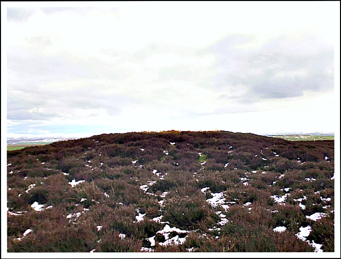
Bleara Lowe burial mound near Earby, Lancashire.
OS grid reference: SD 9258 4543. On the bleak and windswept Bleara Moor, 1 mile east of Earby and above Broom House Farm, Lancashire, stands the prominent little mound known as Bleara Lowe, which is in fact a Bronze Age burial mound (tumulus). It is usually covered in thick heather and not easy to spot at first sight. And 200 metres to the west there is a second burial mound which is next to a wall and some old quarry workings. The site is located along West Road, which runs north from Colne to Carleton-in-Craven, just after Broom House Farm and opposite the entrance to Salt Pye Farm. However, there are “no” designated footpaths going in the direction of the two burial mounds, as they stand on ‘private land’. You can ‘probably’ visit Bleara Lowe by heading east out of Earby and coming up onto the moor from there.
The round-shaped, almost conical mound or bowl barrow is between 4-5 feet high and approximately 20 yards across, according to pastscape. It appears to have an outer bank but the heather makes for difficulty in seeing this. There is a hollow 3m x 1.5m and 0.4m deep in the middle (pastscape), although this is possibly the result of ‘an invalid’ excavation by someone other than archaeologists; no proper excavations have been carried out here and so next-to-nothing is known about its history, other than it is probably of a Bronze-Age date. However, authors John & Philip Dixon ‘Journeys Through Brigantia’, Vol 1, say that: “Upon excavation the mound produced several sherds of Bronze-Age pottery. These can now be seen in the Craven Museum, Skipton.”
Bleara Lowe is aligned with other local burial mounds, cairns and earthworks, and is said to be situated on an ancient trackway linking Boulsworth Hill, where there are similar burial mounds at Ell Clough. And 1½ miles to the north-east, on Elslack Moor, is Pinhaw Beacon at 388 feet.
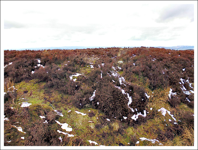
Tumulus above Broom House Farm, Bleara Moor, Lancashire.
Some 230 metres to the west of the Bleara Lowe mound at (OS grid ref: SD 9243 4538) is a second tumulus, burial mound, cairn or bowl barrow. This is situated close to the wall above Broom House Farm and next to what looks like an old quarry-working, now grassed over and partly covered in the dreaded heather. This does, however, have a substantial and well-defined oval-shaped outer bank and a possible inner ditch. It measures roughly 8m x 7m and is 4 feet high. But, once again, no archaeological excavations have been carried out on this second tumulus. It seems to be aligned with Pendle Hill to the west, and is located in a ‘splendid setting’ on the ridge of Bleara Moor, with good panoramic views over to the west and east.
Some 250m to the west of the 2nd tumulus at (OS grid ref: SD 919 457) on the western slopes of Bleara Moor, east of Coolham Lane, there is a cairn-field where there are a number of small burial mounds or round cairns scattered around, but once again, covered by heather. This probable “new discovery” was found by Paul Bennett and is discussed by him on The Northern Antiquarian website (see below).
Sources:
Dixon, John & Philip., Journeys Through Brigantia, Volume One: Walks in Craven, Airedale and Wharfedale, Aussteiger Publications, Barnoldswick, 1990.
http://www.pastscape.org/hob.aspx?hob_id=46285#aR
Copyright © Ray Spencer, The Journal of Antiquities, 2016.
