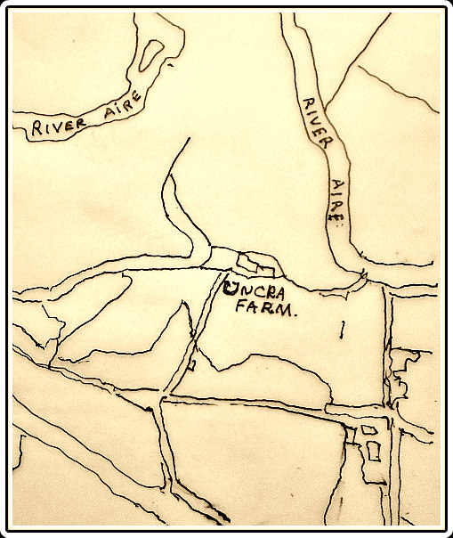
Old Map of Uncra Farm, near Keighley.
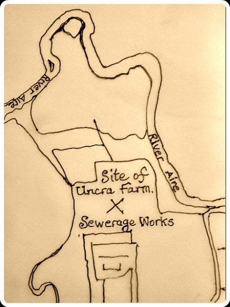
The site of Uncra Farm (today).
NGR:- SE 0858 4142. The lost (forgotten) Roman fort of Uncra was located where the farmstead of that name used to be – close to the bank of the River Aire, and roughly halfway between East Riddlesden Hall and Marley – at the northeastern side of Keighley, West Yorkshire. Uncra farm was said to have been built on the site of the Roman fort or camp. The location of this “lost fort” was in the field at the north side of the present A650, which used to be called Marley Road. However, on the site ‘today’ there is the Marley Sewerage Works, which seems a great shame to me, though the field at the north side might still have slight traces; other than that there are no visible remains. Sadly, it is lost to the Mists of Time. The Roman road from Manchester to Ilkley, or maybe a medieval track, ran through this area and crossed the River Aire by way of a wooden bridge. Fragmentary sections of this, or a later bridge, were excavated in 1929, and a number of Roman coins and, some fragments of a Saxon cross, were found close to East Riddlesden Hall. There is a display of Roman coins in the hall.
Marie Campbell (1999) tells us about this site, saying that: “Long before the River Aire changed its course in about AD 78, a Roman fort is believed to have existed between East Riddlesden and Marley Hall, near Keighley. The road to the fort is thought to have stretched along Hog Holes Lane, Long Lee, cutting along Parkwood Top before its decent to Uncra and Marley. Here it passed over the ford at the River Aire to climb the steep slopes of Morton Banks and beyond. The farmstead of Uncra was supposed to have been erected over the fort’s foundations. From the August pages of the Keighley News 1883 a clue to the site of Uncra Farmstad may be gleaned. Mr F. Morgan, a tenant of Uncra farm, reported smoke rising from a haystack, the property of Mr Wallbank of High Shann Farm. The haystack was in a field by the River Aire, close to his farmstead and bordered by Keighley Corporation tip and local gasworks.”
Campbell goes on to say: “A severe drought in the 1850s at Uncra near Marley revealed an ancient oak and sycamore bridge, 120cms wide and 18 metres across. It rested ‘upon uprights fixed into three blocks of masonry with large-headed nails and wood pegs’. During the 1920s antiquarians digging at the site recovered a large block of stone with a hole in the centre. Masonry dispersed on the water’s edge was thought to be ‘the central pier, the river having changed its course since the bridge was erected’. Horsfall Turner in his History of Ancient Bingley said of Marloe/Marley Bridge. ‘”I have no memo-randum to show this bridge was destroyed”‘. The Sessions Rolls of 1650 to 1700 reveal that, ‘the ford through the water where carts and carriages with wyne and oil and iron pass from the city of York to the market town of Keighley is worn with pitts so as to be very dangerous to passengers’. In January 1687 the wooden bridge was restored at a cost of £230. In 1929 Mr C. Bailey of East Riddlesden Hall granted permission to dig part of the Aire and its banks in this location during a drought. A number of faced stones were found in the mud, about 60cms higher than the course of the river running between Marley and Riddlesden Hall. This was close by the present course of the river near How Beck. Excavations on the North bank uncovered the sycamore central trestle sighted by antiquarians way back in the 1850s. The trestle was removed from the site and presented to Keighley Museum by its finders. It was transferred to Cliffe Castle but has since disappeared, perhaps disintegrating after being dredged from the riverbed. With only obscure references to the existence of the ancient cart ways and bridge to Uncra, had it not been for two very dry spells all may have lain hidden forever from sight.”
Marie Campbell (1999) adds that: “The dreaded Ninth Roman Legion, a body of 5000 men, was stationed somewhere near Uncra in AD117 according to two local amateur archaeologists in the 1980s. They said they believed the whole legion to have been massacred within a two-mile radius of Crossflatts. Two coffers, one containing gold and the other bronze coins, are supposed to have been hurriedly secreted near the banks of the River Aire by Roman paymasters. The Yorkshire Archaeological Society is sceptical about this theory although the archeologists have found, with the aid of a metal detector, several fragments of metal which had once been part of a spear, a metal skirt tailpiece and a medallion. They were dug from the ground close to Druid’s Altar, a plateau high above Uncra and Marley.
“In the summer of 1917, a Mr Bennet discovered a small bronze eagle in almost perfect condition in a newly ploughed field to the north of Parkwood Top Farm, Keighley. The area is identified on the 1919 OS map as enclosure 528. This spot is only a mile or so distant from where the old Roman road from Manchester to Ilkley once ran. Bennet handed the Bronze figure over to Keighley Museum. Expert Alex Curle from the Museum of Antiquities had no doubts as to its Roman authenticity. He thought it might have been a finial for a staff. Again at Parkwood, a hoard of Roman coins was found by a man named Robert Lister in Edwardian times.”
Sources / References & Related Websites:
Campbell, Marie, Curious Tales of Old West Yorkshire, Sigma Leisure, Wilmslow, Cheshire, 1999.
Ordnance Survey, Historical map and guide — Roman Britain, South Sheet, Fifth Edition, Scale: 1:625 000, Ordnance Survey, Southampton, United Kingdom, 2001.
http://roadsofromanbritain.org/gazetteer/yorkshire/rr720a.html
https://www.nationaltrust.org.uk/east-riddlesden-hall
https://en.wikipedia.org/wiki/East_Riddlesden_Hall
Click to access L9970_CompleteRep.pdf
© Ray Spencer, The Journal of Antiquities, 2019.
