The Journal Of Antiquities

Ancient Sites In Great Britain & Southern Ireland


3 Comments

Din Lligwy Ancient Settlement, Near Moelfre, Anglesey, Wales

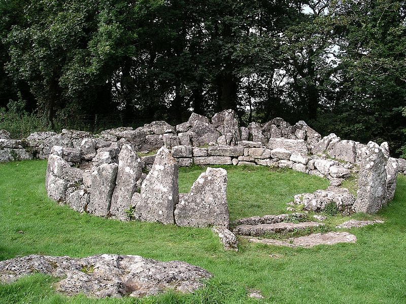
House foundations at   Din Lligwy by Velela (Wikimedia Commons).

   OS Grid Reference: SH 49717 86134. At the eastern edge of Coed cae’r-gaer woods near Rhos Lligwy, Anglesey, stands the well-preserved ancient settlement of Din Lligwy, dating for the most part from the 3rd and 4th centuries AD when it was occupied by a Romano-British tribe, though the first settlers here were people from the late Iron Age period. Set within a walled enclosure there are a couple of hut circles, rectangular structures, and a gatehouse-type building at the entrance. The site is located to the east of the A5025 road about 1 mile west of Moelfre, and not far from the east coast of Anglesey. A little to the northeast of Din Lligwy is Hen Capel Lligwy, a ruined medieval chapel while just over to the east stands the Lligwy Neolithic burial chamber. There is a car-parking area and information boards on the lane over to the east of the site, and a footpath run to the west for 300m, passing close to the ruined chapel, and then to Din Lligwy ancient settlement which nestles in a woodland clearing.

Plan of Din Lligwy Ancient Settlement, Anglesey.

   The ancient settlement or village of Din Lligwy covers about ½ an acre and measures roughly 56m x 53m and is pentagonal-shaped (with five-sides). It sits upon a limestone plateau at the edge of a low hill. Although its limestone walls were built for a partly defensive (fortified) purpose at the time, its more likely they were simply built to ‘enclose’ the buildings, but they obviously followed the standard pattern of earlier Iron Age construction. Inside the enclosure walls are two well-preserved hut circles, or round-houses, built from large limestone slabs around the sides, and also four rectangular-shaped buildings, one of which was perhaps the chieftain’s house, while beside the original entrance (NE side) another building that was probably a gate-house; the entrance (SW side) is later as is the little exterior building. The enclosure walls are a staggering 4-5 feet thick.

    Jacquetta Hawkes in her work ‘A Guide To The Prehistoric And Roman Monuments In England And Wales’, says of this site that: “Within a stout enclosure wall, there is a group of houses, two of them circular, but the rest rectangular in plan and all spacious, splendidly built and almost intact. Nearly all the walls show a massive construction with an inner and outer facing of large slabs and a packing of smaller stones. Din Lligwy shows signs of having buildings of more than one period, but it is known to have been inhabited during the Roman occupation down to the fourth century A.D.; it must surely have been the stronghold of some chieftain of unusual standing—one would like to think that the lord himself lived in the larger round house, a place quite worthy to rank as a Celtic palace.”

   The author Christopher Houlder writing in 1978 says of Din Lligwy: “The two round huts used as living quarters are likely to have been part of an open settlement of early Roman date, included in the strong pentagonal enclosure in the late IV century A.D. Six hearths in two of the rectangular buildings show that they were used for iron workshops, but one was a gatehouse.”

   We don’t know much about the people who lived at Din Lligwy apart from they were Romano-British, but they were probably subservient to the Romans and almost certainly supplied the army with iron weapons and tools made in their own smelting workshops. In this case, then, they were very useful to the Romans and so were more or less left in peace. To the people of Din Lligwy though this situation ‘served as a means to an end’. Then at some point between 385-400 AD they abandoned their settlement/homestead. The Roman army withdrew back to Gaul at about the same time. “There is no evidence that this outstanding site was lived in after about AD 400”, according to Harold Priestley (1976). The site was excavated between 1905-7 when “finds here have included Roman pottery and coins which may be an indication that the occupants were on friendly terms with the Romans”, says Chris Barber (1987).

   Hen Capel Lligwy (Old Lligwy Chapel) over to the northeast is a ruined 12th century chapel with some interesting Norman features. On the opposite side of the lane to the east (at OS grid ref: SH 50135 86039) is the Lligwy Neolithic burial chamber or cromlech. This has a huge capstone that is said to be 18 feet in length, and weighing 28 tons, according to Janet & Colin Bord (1994). “When excavated, the remains of 30 persons were discovered together with animal bones and pottery”, says Harold Priestley (1976).

Sources of information and related websites:-

Barber, Chris, More Mysterious Wales, Paladin, London, 1987.

Bord, Janet & Colin, Ancient Mysteries of Britain, Diamond Books, 1994.

Hawkes, Jacquetta,  A Guide To The Prehistoric And Roman Monuments In England And Wales, Cardinal (Sphere Books Ltd., London, 1975.

Houlder, Christopher, Wales: An Archaeological Guide, Faber & Faber, London, 1978. 

Priestley, Harold, The Observer’s Book of Ancient & Roman Britain, Warne & Co Ltd., London, 1976.

https://en.wikipedia.org/wiki/Din_Lligwy

http://www.megalithic.co.uk/article.php?sid=1494

http://www.anglesey-hidden-gem.com/din-lligwy.html

http://cadw.gov.wales/daysout/dinlligwyhutgroup/?lang=en

http://www.coflein.gov.uk/en/site/95541/details/din-lligwy-settlement-moelfre

                                                                                         © Ray Spencer, The Journal Of Antiquities, 2017.


1 Comment

The Craw Stane, Rhynie, Aberdeenshire, Scotland

The Craw Stane at Rhynie, Aberdeenshire.

   OS Grid Reference: NJ 49718 26343. In a field just to the south of the village of Rhynie, Aber-deenshire, beside the earthworks of the ancient settlement overlooking the Water of Bogie, stands The Craw Stane or Crow Stone, a granite slab with Pictish symbols that are thought to have been carved in the 5th century AD. Several more Pictish stones have been found in this area including one called ‘Rhynie Man’, which now stands in the Council HQ in Aberdeen. The Craw Stane stands at the south-side of what is probably a prehistoric mound or cairn.  It can be reached along Manse Road, south out of Rhynie for ¼ of a mile. After St Luag’s church and cemetery follow the footpath heading to the southwest; the stone can be seen in front of you. Or it can be viewed from the side of the road by going south for 100m out of the village on the A97 (Main Street) and from nearly opposite the entrance to Mains of Rhynie.

   The Craw Stane or Crow Stone (also called Rhynie No 1) stands on the south-facing slope of the hill above the Bogie Valley and at the E side of the ancient earthworks of a Settlement and Enclosure (where there have been a number of archaeological finds) – at the W and SW sides of which are a couple of burial mounds from a much earlier date – the southwestern mound is quite large and could be a long cairn; at the southern edge of this the stone is to be found. It is a granite slab measuring 5 feet 7 inches high by 3 feet wide and stands on a stone base. This Class I symbol stone has two quite distinct symbols: a fish and a beast. The fish is probably a salmon while beneath that the beast might be any large animal, but the suggestion is that it is an elephant, but it is more likely to be a mythical creature. These carvings were probably done in the 5th or early 6th century AD, long before the Picts were Christianized.

   Several more Pictish stones can be found in and around the village of Rhynie. One known as Rhynie Man or Rhynie No 7 has a carving of an ogre with a big nose, sharp teeth, and a rather fragile axe; this now stands in the Regional Council HQ at Aber-deen. Another, The Barflat Stone or Rhynie Barflat No 8, is another Class I symbol stone that was ploughed up at Barflat farm in 1978 and had a beast, curvilinear symbol and comb, but is now also at Regional Council HQ, says Elizabeth Sutherland. Two stones that are damaged can be found at the entrance to the graveyard of Rhynie Old Church which is dedicated to St Luag (OS grid ref: NJ 4994 2650). Both were removed from the foundations of the original church when it was demolished in 1878, so says Elizabeth Sutherland. No 5 has a beast’s head, double disc and Z rod beside a mirror and single-edged comb, while No 6 has part of a double-disc and Z rod above a crescent and V-rod with a mirror below. Two more stones Nos 2 & 3 stand on Rhynie village green (OS grid ref: NJ 4980 2715) but are damaged. No 2 has carvings of a double-disc and V-rod, now invisible, while No 3 shows a man’s back, spear and disc, again according to Elizabeth Sutherland in her excellent work “The Pictish Guide’. There is also further information in ‘The Pictish Trail’ by Anthony Jackson.

Sources of Information and related websites:-

Jackson, Anthony, The Pictish Trail, The Orkney Press Ltd., St Ola, Kirkwall, Orkney, 1989.  

Sutherland, Elizabeth, The Pictish Guide, Birlinn Limited, Edinburgh, 1997.

The AA, Illustrated Road Book Of Scotland, The Automobile Association, London, 1963.

https://en.wikipedia.org/wiki/Rhynie,_Aberdeenshire

http://www.megalithic.co.uk/article.php?sid=12063

https://canmore.org.uk/site/17199/rhynie-craw-stane

http://portal.historicenvironment.scot/designation/SM69

                                                                                    © Ray Spencer, The Journal Of Antiquities, 2017.


Torphichen Sanctuary Stone, West Lothian, Scotland

Torphichen Sanctuary Stone

   OS Grid Reference: NS 96842 72506. An ancient standing stone known as the ‘Torphichen Sanctuary Stone’ is to be found at the west-side of the kirkyard and preceptory of Torphichen parish church, 2¼ miles to the north of Bathgate in west Lothian, Scotland. The stone has five small prehistoric cup-marks, but also a Celtic-style carving from the Dark Ages when St Ninian lived here, while on the top of the stone there is a medieval incised cross and a small hollow.  It is the central-most stone of three – the other two being within a 1 mile radius of the preceptory. The thinking is that the santuary stone came from the ancient site of Cairnpapple Hill, about 1½ miles to the east. Torphichen’s medieval church and preceptory are located at the east-side of the village on The Bowyett, which runs off from the B792 road. You will find the little standing stone set amongst the gravestones at the west-side of the grassy kirkyard.

   The little standing stone was set up here in the 12th century by the Knights Hospitallers (Knights of St John) to mark out a place of sanctuary or refuge for local people and pilgrims from further afield who wished to seek ‘a place of safety here’, or more likely the stone was already here when the Knights founded their preceptory/hospital and church in 1168; an incised cross was carved on the top of the stone and the little hollow carved to either hold a cross or maybe holy water? But the stone was used at an earlier date by St Ninian, who had settled here in the 4th century and, in the 7th century St Fechin, an Irish monk and missionary from the monastery of Fore, County Westmeath, apparently also made use of this standing stone – the Celtic-style carving on the stone would date from this time. The five small cup-marks on the side of the stone date from the early Bronze Age when it stood on Cairnpapple Hill where there is a Neolithic henge monument and Bronze Age cairn. The pre-ceptory which was the Knight’s Hospitallers Scottish base, is now in ruins although the central tower, west tower-arch and transepts remain; the nave was rebuilt in the 17th century and now forms part of the present parish church. Some of the domestic buildings and parts of the hospital also still stand.

   There are two other associated sanctuary (refuge) stones (West and East) both of which stand about 1 mile distant from the central stone here in the Torphichen kirkyard. The W stone, which had a Maltese cross carved upon it, is located at Westfield farm (OS grid ref: NS 9437 7211) while the E stone is at Easter Gormyre farm near the hamlet of Gormyre (OS grid ref: 9806 7311), according to the Canmore website entries.

Sources of information and related websites:-

Ancient Monuments — Scotland, Volume VI, H. M. Stationery Office, Edinburgh, 1959.

Bottomley, Frank, The Abbey Explorer’s Guide, Kaye & Ward, London, 1981.

The AA, The Illustrated Road Book Of Scotland, The Automobile Association, London, 1963.

http://www.megalithic.co.uk/article.php?sid=30653

https://en.wikipedia.org/wiki/Torphichen_Preceptory

http://www.armadale.org.uk/torphichen.htm

https://canmore.org.uk/site/47929/torphichen-churchyard-refuge-stone

https://canmore.org.uk/site/48010/westfield-farm-refuge-stone

https://canmore.org.uk/site/47915/gormyre-refuge-stone

                                                                                     © Ray Spencer, The Journal Of Antiquities, 2017. 


1 Comment

The Blowing Stone, Kingstone Lisle, Berkshire (Oxfordshire)

Blowing Stone at Kingstone Lisle, Berks.

   OS Grid Reference: SU 32408 87078. A strange and curious stone standing inside a fenced-off area next to a row of quaint cottages on Blowingstone Hill, at Kingstone Lisle, formerly in Berkshire, now Oxfordshire, is the so-called ‘Blowing Stone’, a squat-shaped lump of ancient rock with deep holes in it that is ‘said’ to have originated on White Horse Hill nearby, when it was a perforated sarsen stone. It has a number of myths and legends attributed to it from the time that it was known as the King Stone; the village taking its name from this. The stone also figures in a well-known book that was read by many-a school-boy. This apparent ‘curiosity of geology’ is located just to the south of the village itself and the B4507 road, between the towns of Swinden and Wantage. Kingstone Lisle Park is over the road on the opposite side of the lane from where the stone is now a resident ancient monument, though it used to stand in the garden of the cottage close by, which used to be the village inn!

   The Blowing Stone, also known as King Stone, is in fact a sarsen stone that was originally to be found upon White Horse Hill, 3 miles to the southwest, but was moved to its present location in the mid-18th century. It is curious lump of stone with many geologically-formed perforations, maybe the result of fossilized plants or ancient tree branches falling out of the stone leaving holes; some quite large holes or perforations that go all the way through from one side to the other. But it is not a particularly large stone being just 3 feet in height and about the same in width.

   The stone featured in the famous novel of 1857, ‘Tom Brown’s School Days’ by Thomas Hughes (1822-1896) – when it was referred to as the ‘Blawing Stwun’. Local legend has it that by sounding a note through the largest hole, or by blowing and bellowing through the holes, the sound made by doing this is audible as an echo up to 3 miles away – and that King Alfred the Great summoned his Saxon army into battle against the Danes at nearby Ashdown by doing just that, in the form of a trumpet call! It is also claimed that anyone sounding a high-pitched note through the Blowing Stone (that can be heard on White Horse Hill to the southwest), will be, or would be, a future king of England, or so The Legend tells us. Something similar, perhaps, to the legend of King Arthur, although he supposedly pulled a sword out of a rock. 

Sources of information and related websites:-

Reader’s Digest, Folklore Myths and Legends of Britain, Second Edition, The Reader’s Digest Association Limited, 1977.

The AA, The Illustrated Road Book Of England & Wales, The Automobile Association, London, 1961.

https://en.wikipedia.org/wiki/Blowing_Stone

http://www.berkshirehistory.com/archaeology/blowing_stone.html

http://www.kingstonlisle.net/the-blowing-stone/

http://www.megalithic.co.uk/article.php?sid=6963

                                                                                   © Ray Spencer, The Journal Of Antiquities, 2017.


Robin Hood’s Well, Helmshore, Lancashire

Robin Hood’s Well near Helmshore, Lancashire.

   OS Grid Reference: SD 77860 19544. At the north-eastern edge of Holcombe Moor and beside Moor Road, locally called Stake Lane, 1 mile south of Helmshore, Lancashire, is Robin Hood’s Well/Spring. The well is located at the side of the old pilgrim’s route that led to Whalley Abbey and which passes close to the medieval Pilgrim’s Cross, that is now nothing more than a stone-base on the moor. There are no records to say that Robin Hood’s Well ever had healing powers, or to it being a sacred spring, but it must have had some holiness attributed to it by the monks and pilgrims who visited it and drank of its waters back in the mists of time. And there is nothing that says Robin Hood the outlaw of Sherwood Forest ever visited the well, though there is a Robin Hood’s Inn down in Helmshore village. It may originally have been called Pilgrim’s Well.  To reach it walk south along Moor Lane for 1 mile from the village of Helmshore, or go up the footpath from the B6214 (Helmshore Road) near Pleasant View Farm. Follow the path across the farm track and up over the fields over the wall stiles to the rough track (Stake Lane) at the top. Go through the wooden gate on the right and the well is below the wall in front of you.

Robin Hood’s Well.

Close-up of the pool below the spring.

   The author John Crawshaw writing in Source – The Holy Wells Journal, gives us a fair bit of interesting information with regard to the well. He says that: “Situated near Helmshore, on the edge of the ancient  Forest of Rossendale in Lancashire is Robin Hood’s Well. This well is near an ancient pilgrim’s route which passes by the Pilgrim’s Cross (which was in existence in A.D. 1176), on Holcombe Moor, and goes through the town of Haslingdon on its way to Whalley. In Anglo Saxon times Whalley church was an important minster and the mother church of an enormous parish. Later, in the medieval period, several chapels-of-ease were attached to Whalley church for the “ease” of the scattered population providing access to the Mass and the sacraments

   “After the move made by the Cistercian monks of Stanlow to Whalley at the end of the thirteenth century, traffic would have increased along this route. About one mile to the north of Pilgrim’s Cross, near this pilgrimage route is Robin Hood’s Well.

Pyramid-shaped stone above the well/spring.

   “The spring issues  out from beneath a large, worn stone capping: shaped rather like a flattened pyramid with a blunt apex. This is set against a drystone wall by the side of Stake Lane. The water falls from the well-head into a small pool and the whole arrangement of stones has the appearance of great age. The flattened pyramid-shaped piece of sandstone covering the well has several worn, carved indentations upon it, one of which, near the left-hand side at the front, is a wide groove. It is possible that this was made by the wearing down of the stone by a chain securing a drinking cup at its end. However, no trace of any chain or cup can now be discerned.”

   Mr Crawshaw goes on to say that: “Though it is reasonable to assume that this well was used by pilgrims on their way to Whalley church and later, the great Cistercian abbey there. I have not been able to discover any recorded references to its original dedication: nor does there seem to be any written record reciting any healing properties attributed to the water. It is possible of course that any such references are lost or were never recorded, or perhaps the well’s reputation  in the middle-ages was merely that of a providential source of drinking water on a pilgrim’s route, where prayers were said in gratitude for the slaking of the pilgrim’s thirst.

   “I have a theory that in fact the name of the well may have been brought into use following the 16th century religious reformation. I understand the term , “the play of  Robin Hood” was used by the 16th century Lancastrian religious reformers as a derogatory nick-name to describe the rituals and ceremonies of the old English Catholic Church. These reformers had no use for pilgrimages to holy sites such as the ancient parish churches, the shrines of saints or holy wells; indeed they denounced them as being of no spiritual value.

   “One of the most famous Lancastrian reformers, John Bradford, in his Christmas sermon delivered in Manchester in 1552, threatened the people that, if the town did not “readily embrace the Word of God, the Mass would be said again in that church, and the play of Robin Hood acted there”, ¹ which did indeed come to pass during the reign of Queen Mary. I believe that this ancient spring derives its name from this time, when the practice of visiting such wells was being denounced as “superstitious”.

   “The Elizabethan “settlement of religion”, having swept away the piety and traditional Catholic practices of the old Ecclesia Anglicana, had no use for pilgrimages which, in theory at least, it had outlawed. So, following the dissolution of Whalley Abbey and the official prohibition of the old Faith, this spring on an ancient pilgrim’s route appears to have fallen into being regarded merely as a source of water by the side of a little-used moorland lane.” 

Sources of information and related websites:-

Crawshaw, John, (Robin Hood’s Well), Source—The Holy Wells Journal,  New Series No 6—Summer 1998, Pen-y-Bont, Bont Newydd, Cefn, St Asaph, Clwyd, 1998.

¹ Haigh, Christopher, Reformation and Resistance in Tudor Lancashire, 1975, Cambridge University Press, Ch.11, 168.

http://www.pastscape.org.uk/hob.aspx?hob_id=44289

https://en.wikipedia.org/wiki/Helmshore

https://haslingdens.blogspot.co.uk/2016/01/historic-water-troughs-and-spring-fed.html

                                                                                  © Ray Spencer, The Journal Of Antiquities, 2017.