The Journal Of Antiquities

Ancient Sites In Great Britain & Southern Ireland


St Patrick’s Chapel And Rock Graves, Heysham, Lancashire


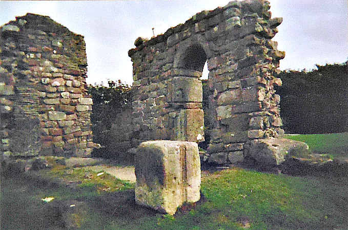
St Patrick’s Chapel on Chapel Hill, Heysham.

   OS Grid Reference: SD 40980 61628. On the headland above St Peter’s parish church at Heysham, in Lancashire, stand the ancient ruins of St Patrick’s Chapel, a Saxon building dating from either the 8th or 10th century AD. Also upon Chapel Hill, overlooking Heysham Sands, and just opposite the ruined chapel there are two sets of rock-hewn graves that are said to date from the 11th century AD. It is thought to be very unlikely that Ireland’s patron saint ever set foot on Heysham Head, as much as that makes for a very good story, although beneath the ruined chapel’s stonework there are the foundations of an earlier Celtic-style chapel – maybe dating back to the 6th century AD. To reach St Patrick’s Chapel: from Main Street take the rough track that heads west past St Peter’s churchyard entrance, and then slightly up hill for a while, then take the footpath that veers off the rough track for a few metres up to Chapel Hill and the ruined chapel with the curious rock-cut graves close by.

St Patrick’s Chapel, Heysham, from a different angle.

   The chapel measures 27 feet by 6 feet and is built from large, rough-hewn lumps of sandstone, with thinner rubble coursework sections between and at the top, but the curved Saxon doorway is by far the best part of the structure. According to Richard Peace (1997) the sandstone blocks that make up the chapel are: “fused together by molten shells.” However, a large part of the chapel has now gone through robbery of the stonework, or it has been used elsewhere in the vicinity, or maybe just lost to time. But beneath the ruin there are the foundations of an earlier Celtic-style chapel of the 5th or 6th century AD. It had been thought that the little building dated back to c750 AD, but in reality it probably dates from the 10th century AD, which would make it “contemporary with the earliest part of St Peter’s Church”, according to Eileen J. Dent (2003).

   The original Celtic chapel beneath the present ruin was most likely “due to the efforts of monks from Ireland, acting as missionaries to St Patrick”, says Eileen J. Dent. It’s almost certain that St Patrick of Ireland never set foot in Heysham, although traditionally he was shipwrecked off the Lancashire coast in the 5th century AD. More likely his followers came here. There are, however, a few holy wells named for him in the area. Nikolaus Pevsner (1979) says of the chapel that it is: “A plain rectangle, 27½ by 9 ft. The S doorway has an arch made of one with concentric grooves. Dating varies between the c8 and c9.”                                                                                              

   Author Eileen J. Dent says that: “In 1977-8 archaeologists found decorated plaster among the foundations of the earlier building. From discoveries, it would seem that the chapel was used only for worship and burial, and never used as a place of habitation. For example it could not have been a hermitage. There is no registration of the chapel as a chantry.

   “The chapel and the ground to the south were used as burial places. Some skeletons were found within the chapel and many more in the ground outside. The soil level is very shallow, and although the skeletons were in layers, none was buried deep.

   “G. Grainger, in an as yet unpublished paper [1977-8], says that the skeletons were generally in a poor condition, but there was probably a total of between 78 and 84 individuals, of various ages, and of both sexes. His tests showed that about one fifth of the population died before the age of 10 and that none survived beyond the age of about 45. After examination the bones were re-interred in the present churchyard.”

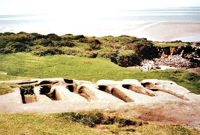
Rock-cut graves at Heysham, Lancashire

   Opposite St Patrick’s Chapel are six rock-hewn graves that are carved out of a large flat sandstone rock. Two of these are straight-sided and four body-shaped, each having a hole at the top, which might have been for a wooden cross. Close by there are another set of two graves but these look to be of a later, Medieval date, maybe from the 13th century? The set of six graves are thought to date from the 9th-11th centuries AD, but more likely to be of the latter century, which would make them Viking in origin. The question must be then, were the priests that served St Patrick’s chapel buried in these graves? That we don’t know but I would think they probably were. Today the rock graves are often filled with rainwater. The graves are Grade II listed and a Scheduled Ancient Monument.

   Author Eileen J. Dent says that: “The stone-cut graves were also examined in the 1977-8 dig. These are not unique. There are other rock-cut graves in the Isle of Man, and similar ones in Spain (Aragon). Archaeologists say that ‘a primary date is likely’, that is, contemporary with the first occupation of the site, but little is known about them, except that they were more likely to be reliquaries than containers for whole bodies.”

Illustration of the Hog-back tombstone in St Peter’s, Heysham.

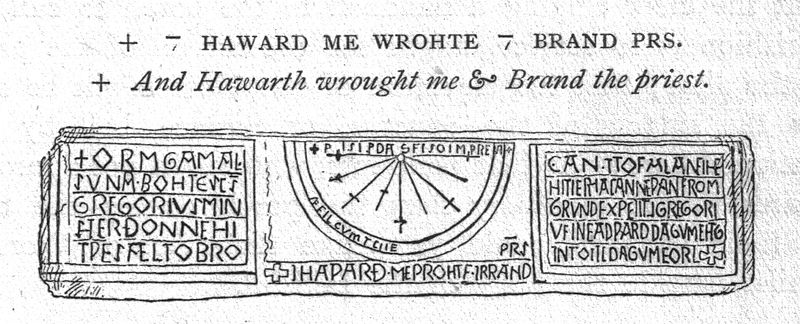
   Below Chapel Hill stands the ancient parish church of St Peter parts of which date back to the Saxon period. Beside the pathway to the church there is the stump of an Anglo Saxon cross-shaft, which might be of the 9th century AD. It stands at just over 2½ feet high and is in the form of a house with windows and a door carved onto it – with faces and figures looking out. There is perhaps an association here with the visit of the three Marys to the sepulcher, or the raising of Lazarus, according to Nigel & Mary Kerr (1982). The upper three windows have faces looking out and a shrouded figure in the doorway below. There is also a round-headed panel (west face) with a saint holding a book, and below that and on the sides are foliage scrolls, say Nigel & Mary Kerr. Housed within the church (south aisle) is a hog-back tombstone of the 10th or 11th century AD. This used to stand out in the graveyard but was brought into the church (1961). It is richly decorated with scenes of stag-hunting from the Norse Legend of Sigurd. There is also zigzag carving, and at either end strange creatures cling to the stone, but whether they are hogs or bears is open to question. Almost certainly it was the gravestone of a wealthy Viking warrior.

Sources and related websites:-

Dent, Eileen, J., Heysham – a History, The Rector & Parochial Church Council of St Peter’s Church, Heysham, & Heysham Heritage Association, 2003.

Fields, Ken, The Mysterious North, Countryside Publications, 1987. 

Kerr, Nigel & Mary, A Guide To Anglo Saxon Sites, Paladin (Granada Publishing Limited), St Albans, Herts, 1982.

Peace, Richard, Lancashire Curiosities, The Dovecote Press Ltd., Stanbridge, Wimborne, Dorset, 1997.

Pevsner, Nikolaus, The Buildings of England – North Lancashire, Penguin Books Ltd., Harmondsworth, Middlesex, 1979. 

https://en.wikipedia.org/wiki/St_Patrick%27s_Chapel,_Heysham

https://historicengland.org.uk/listing/the-list/list-entry/1020535

http://www.sandhak.co.uk/html/history_of_heysham.html

https://en.wikipedia.org/wiki/St_Peter%27s_Church,_Heysham

                                                                                © Ray Spencer, The Journal Of Antiquities, 2017. 


Brownshill Dolmen, County Carlow, Southern Ireland

Brownshill Dolmen in Co Carlow, Southern Ireland

   Irish Grid Reference: S 75440 76846. In a field a little to the east of the village of Browneshill in County Carlow, Southern Ireland, is the Neolithic monument known as ‘Brownshill Dolmen’ or ‘Brownshill Portal Tomb’ and sometimes as Browne’s Hill Dolmen. But it also goes under the name of Kernanstown Cromlech. The monument has a huge capstone weighing over 100 tonnes, But sadly, however, it has lost its covering mound of earth and a few of its upright supports have collapsed under the enormous weight of the top-stone, although three uprights at the front are still supporting it – two of which form the portal (entrance) to the tomb. The dolmen is located almost 2 miles east of Carlow town near the R726 road. It is best reached to the east of Browneshill village: from the R726 (Hacketstown road) at Ballinakillbeg take the footpath for 550m that heads south from the road, then heads west for quite a distance, and then north to the ancient monument – which stands in the corner of the field.

Brownshill Dolmen. Photo by Sarah777 (Creative Commons).

   The Brownshill Dolmen is really much like a ‘stone table’ or ‘tombstone on legs’ resting horizontally (vertically) on up-right stones’; but it is also called a cromlech and portal tomb (a tomb with an entrance). In the Nicholson ‘Guide To Ireland’, we are told that the: “Browne’s Hill Dolmen……with largest capstone in Ireland, if not Europe, 5 feet thick, 20 feet square and weighing over 100 ton. Two up-right portal stones (orthostats) support the huge granite capstone at the front, while the third supporting stone is a ‘gate-stone’ or ‘blocking stone’; these three entrance stones are between 5-6 feet high. There is a fourth stone at the front which may have been part of the forecourt, although this points at an angle away from the tomb. At the back of the monument two recumbent stones support the capstone near ground-level, but whether these two stones collapsed under the weight or were originally placed like this, is not known. I would think they were placed as such. Originally the tomb was covered by a mound of earth. The megalithic monument is said to be almost 4,000 years old and was the burial place of a Stone Age chieftain, according to Reader’s Digest ‘Illustrated Guide To Ireland’.

Sources of Information and related websites:-

Nicholson, Guide To Ireland, Robert Nicholson Publications Limited, London, 1983.

Reader’s Digest, Illustrated Guide To Ireland, The Reader’s Digest Association Limited, London, 1992. 

https://en.wikipedia.org/wiki/Brownshill_Dolmen                                                                                                                         https://en.wikipedia.org/wiki/Brownshill_Dolmen#/media/File:IMG_BrownshillDolmen.jpg

https://irisharchaeology.ie/2016/04/brownshill-portal-tomb-co-carlow/

http://www.megalithic.co.uk/article.php?sid=6333452

                                                                                       © Ray Spencer, The Journal Of Antiquities, 2017.


1 Comment

Saxon Sundial at St Gregory’s Minster, Kirkdale, North Yorkshire

Anglo-Saxon Sundial at St Gregory’s Church, Kirkdale, north Yorks.

   OS Grid Reference: SE 67688 85776. Above the inner south door of the the ancient minster-church at Kirkdale near Kirkbymoorside, north Yorkshire, there is an Anglo-Saxon sundial of unique standing that is most beautifully carved and inscribed. It was reputedly carved in 1060 AD, just before the Norman Conquest of Britain. Also in the church which is dedicated to St Gregory are two carved Saxon grave-slabs and a number of fragments of Anglo Saxon cross-heads, and other antiquities most of which probably date from the late medieval period. The church of St Gregory is built on the site of an Anglo-Saxon church and monastery that was perhaps founded by St Cedd, or St Aiden, sometime after 650 AD. Though St Cedd was thought to have founded Lastingham church (659). This secluded church is 1½ miles to the west of Kirbymoorside village and just north of the A170 Helmsley to Kirkdale road. It can be reached on narrow country lanes – one of which is called Back Lane – the church being located at the northern end of ‘this’ country lane and in the opposite field above. 

   The church guide book compiled by Mr Arthur Penn in 1970 is very helpful here. It says  that: “The dial seems to be in its original position, and consists of a stone slab, seven feet long, divided into three portions. The centre one is the dial, while the outer ones contain an inscription recording the rebuilding of the church, and giving a fairly exact date.

   “The dial itself is divided into eight, which accords with the octaval system of time division, common among the Angles. The double cross on the first line denotes ‘daegmael’ or ‘day-time,’ and may be the time of the first service. The inscription above reads:- ‘This is day’s sun marker at every time.’

Kirkdale Sundial by:- Charles J. Wall (1912). Wikipedia.

   “The outer panels are curious in that the lettering on the first is even and well-spaced, while that on the third is compressed and yet it still was not able to hold the whole inscription, which was continued at the foot of the second panel. Clearly the work was never planned out. The inscription in modern language reads:- Orm Gamal’s son bought S. Gregory’s Minster when it was all broken down and fallen and he let it be made anew from the ground to Christ and to S. Gregory in the days of Edward the King and of Tosti the Earl. And Haward me wrought and Brand Priests. 

   “The inscription also tells us that  the work was carried out in the days of King Edward (the Confessor) and of Earl Tosti. Tosti or Tostig, who became  Earl of Northumberland in 1055, was banished for a variety of crimes, including the murder of Orm’s father, Gamal, in 1065, but returned with Harold Hardrada, King of Norway, in the following year. The Norwegian army fought against Tostig’s brother, Harold  Godwinson, King of England, at Stamford Bridge, and there both Tostig and his Norwegian ally were killed. After the battle Harold Godwinson carried out his forced march to Hastings, where he was killed in battle by the Norman army of William the Conqueror. The sundial thus dates the building between 1055 and 1065. Its inscription in Northumbrian English has traces of runic characters, but is not difficult to decipher.”

Kirkdale Saxon Sundial (a close-up of the dial).

   Nigel & Mary Kerr (1982) tell us more about the hours of the day shown on the sundial. They say that: “The lines with cross bars correspond with 6 a.m., noon , 3 pm., and 6 p.m., the uncrossed lines divide each tide into one-and-a-half-hour periods. The line with a cross on it on the left-hand side of the dial  denotes 7.30 a.m., which marked the beginning of ‘day time'”. They also say with regard to the panels at either side of the dial: “that Orm rebuilt the church in the reign of Edward the Confessor, and the central inscription reads, in translation: ‘This is the day’s sun-marking at every hour. And Hawaro made me, and Brand, priest [?].'” 

   St Gregory’s minster-church houses a number of antiquities from the Anglo Saxon period. There are two sculptured coffin lids in the north aisle one of which is called ‘The Ethelwald Stone’ which dates from the 10th century and recalls Aethelwald, King of Deira, while another called ‘The Cedd Stone’ has interlacing and is thought to date from the 10th century. This also has carvings on its side including V-shaped tassels with little ball-ends. This may be a representation of a pall, which was a cloth draped over a coffin. If it was, then the work was doubtless very fine, providing another outlet for the needleworking skills of Anglo-Saxon ladies, say Nigel & Mary Kerr (1982). In the north aisle there are a number of fragments of cross-heads from the 11th century  – one of which has been fashioned from pock-marks rather than the usual design of one continuous line. Also in the north aisle is ‘The Archer’s Stone’, while at the eastern end of the aisle a 14th century fragment with the Virgin and Child carved upon it. The octagonal font is Transitional and 13th century in date.

   Ella Pontefract, writing in 1937, says of the minster that:- “Kirkdale is a satisfying church in a most beautiful situation, and it should not be missed.” Malcolm Boyes & Hazel Chester (1996) also reflect on the beauty of the place and its location in the peaceful valley beside Hodge Beck.

 Sources of information and related websites:-

Boyes, Malcolm & Chester, Hazel, Discovering The North York Moors, Smith Settle Ltd., Otley, West Yorkshire, 1996.

Jones, Lawrence E. & Tricker, Roy, County Guide To English Churches, Countryside Books, Newbury, Berkshire, 1992.

Kerr, Nigel & Mary,  A Guide to Anglo Saxon Sites, Paladin (Granada Publishing Limited), London, 1982.

Penn, Arthur (Compiler), St Gregory’s Minster Kirkdale, Parochial Church Council, 1970.

Pontefract, Ella, The Charm of Yorkshire Churches, The Yorkshire Weekly Post, Leeds, 1936-7.

https://en.wikipedia.org/wiki/Kirkdale_sundial

https://en.wikipedia.org/wiki/St_Gregory%27s_Minster,_Kirkdale

http://greatenglishchurches.co.uk/html/kirkdale.html

http://www.ling.upenn.edu/~kroch/scand/kirkdale.html

http://www.megalithic.co.uk/article.php?sid=13357

                                                                                       © Ray Spencer, The Journal Of Antiquities, 2017.