The Journal Of Antiquities

Ancient Sites In Great Britain & Southern Ireland


Coldrum Stones (Long Barrow), Near Trottiscliffe, Kent

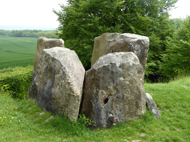
Coldrum Long Barrow, Kent. Photo: pam fray (Creative Commons).

NGR:-TQ 65438 60726. About a ¼ of a mile to the east of St Peter’s & St Paul’s Church, Trottis-cliffe, Kent, stands the megalithic monument known as ‘Coldrum Stones’ or ‘Coldrum Long Barrow’, which dates from the late Neolithic. In the ownership of the National Trust this ancient burial chamber lies at the side of a field, ½ a mile to the south of The Pilgrim’s Way, and over-looking the Medway Gap. The little village of Trottiscliffe which one must go through is known ‘very fondly’ to local people as “Trosley”. The four very large and impressive stones are all that remains of the burial chamber, which would have had a mound over it. In 1910 the structure was excavated and more than 20 individuals were found along with the bones of many animals from around 2,000 BC. At the east side of Trottiscliffe village: drive or walk along Church Lane for ¼ of a mile past the church, then soon turn north on narrow lane to the carpark. Or from the church continue east along Coldrum Lane, then north to the monument. From carpark take footpath east, then south, for a short while to reach Coldrum Stones Ancient Monument, which lies in front of you – more or less.

Christopher John Wright (1981) tells in great detail about: “The Coldrum Stones, or more properly the Coldrum Long Barrow, are the remains of a Neolithic burial chamber. They are today the property of the National Trust, given in 1926 as a memo-rial to the Kentish archaeologist and antiquary Benjamin Harrison (1837-1921), and a bronze plaque mounted on one of the stones near the path records this presentation.

“Once the circle with the dolmen stood complete upon its raised knoll overlooking the Medway Gap—a circle of towering columns 160ft/80m in circumference. Now the eastern half of the knoll is gone, probably when chalk was being excavated or cut away when the road, now no more than a bridlepath, was made. Half the circle has fallen down as a result, but four massive sarsens about 12ft x 10ft/3.6m x 3m stand poised on the brink. The remainder of the circle lie prone in a more or less regular arrangement on top of the knoll—fallen giants of almost equal size strewn across the slope. Even now in its ruined state the monument is impressive and its site, facing the wide river valley, striking.”

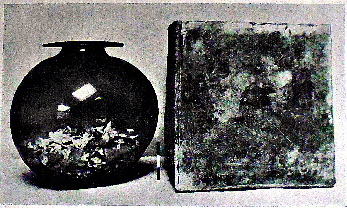
Wright goes on to say that: “The remains of 22 Neolithic people, together with some bones of the ox, deer, rabbit, and fox ascribed to the period about 2000 BC were discovered here in 1910, and they were displayed in Trottiscliffe church.

“The Coldrum Stones is a complex megalithic tomb and one of a remarkable group of dolmens found in this part of the Medway valley, between Wrotham and Boxley, described as the ‘Kentish Stonehenge’. These structures were all of Neolithic origin and were, without exception, burial places. The great stones are all sarsens, and are comprised of sand hardened into masses by silica infiltration, the presence of iron often resulting in a yellow-brown staining. The stones are not of any composition quarried locally, and it is possible that they were strewn about during the ice age and collected together to be erected for this purpose.” 

Timothy Darvill (1988) says of the site, that: “Starting west of the River Medway the first site to see is the Coldrum Long Barrow……, probably the best preserved of all the Medway sites. It sits on a low ridge in the shadow of the North Downs and faces east towards the Medway. The mound is slightly wedge shaped, about 20m long, and edged with a ring of rounded sarsen boulders known as peristalith. The chamber at the east end, partly restored, survives as four upright stones forming three sides of a simple box-like structure. Excavations revealed that at least 20 individuals had been buried in it. As visible today, however, the east end of the site has been truncated; originally the ground would have sloped away from the tomb more gently than it does now.”

Darvill (1988) tells of some more nearby megaliths, saying that: “Just over a mile south of Coldrum are a pair of long barrows at Addington. The larger of the two, the Addington Long Barrow [NGR: TQ 654592], lies west of the village and is crossed by the minor road leading to Wrotham Heath. The mound is 60.3m long by 14m wide. Traces of a peristalith and the re-mains of a collapsed chamber at the eastern end can still be seen. About 100m north-west of the Addington Long Barrow is the Chestnuts Long Barrow [NGR: TQ 652592], accessible by asking permission at the house in whose grounds it stands.”

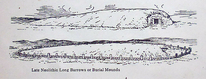
Two examples of Neolithic Long Barrows.

Jacquetta Hawkes (1973) says of the site: “This is a good monument to visit first, for it at once makes clear the general character of all the rest. Coldrum plainly consists of a closed burial-chamber towards the eastern end of a rectangular setting of stones which once enclosed a long mound, now much reduced in size. Unfortunately the huge capstone which should roof the chamber has been lost—but at Kit’s Coty we shall be able to see another example still in position. This chamber was re-excavated in 1910, and the bones found in it were for a time almost the only surviving relics from any of these Kentish graves; in 1940 the museum of the Royal College of Surgeons in which most of them lay was completely destroyed by a bomb. The remains of many individuals, including babies, were identified; one skull, belonging either to the most important or the most recently buried corpse, was found resting on a stone shelf supported by two blocks of ironstone. The skeletons were recognized as belonging to a small, long-haired people of the kind which in the past it was permissible to call Mediterranean. Nowadays one has to be more cautious.”   

Janet & Colin Bord (1994) say: “A ley 4½ miles length was surveyed in Kent by Paul Devereux, editor of The Ley Hunter magazine, and he found that there was a legend of a tunnel connecting Coldrum barrow with Trottiscliffe church, following the line of the ley. The legend also said that there was hidden treasure in the tunnel, a feature also found in other similar tales, which could refer to the power or energy flowing along the ley.”

Sources / References & Related Websites:-

Airne, C. W, M.A. (Cantab.), The Story Of Prehistoric & Roman Britain — Told In Pictures, Sankey, Hudson & Co. Ltd., Manchester,

Bord, Janet & Colin, Ancient Mysteries of Britain, Diamond Books, Birkenhead, 1994.

Darvill, Timothy, GloveBox Guide — Ancient Britain, The Automobile Association (Publishing Division), Basingstoke, Hampshire, 1988.

Hawkes, Jacquetta, A Guide To The Prehistoric And Roman Monuments In England And Wales, Cardinal (Sphere Books Ltd.,) London, 1975. 

Wright, Christopher John, A guide to The Pilgrims’ Way and North Downs Way, Constable & Company Ltd., London, 1981.

Photo (top) by pam fray:   https://www.geograph.org.uk/photo/4956966

https://en.wikipedia.org/wiki/Coldrum_Long_Barrow

https://thejournalofantiquities.com/2012/09/13/kits-coty-walderslade-kent/

https://www.nationaltrust.org.uk/coldrum-long-barrow

https://www.megalithic.co.uk/article.php?sid=359

https://www.atlasobscura.com/places/coldrum-long-barrow

https://www.cantab.net/users/michael.behrend/repubs/j_geomancy/v1n3/pages/bullion_kent.html

© Ray Spencer, The Journal of Antiquities, 2019.


2 Comments

Uncra Roman Fort, near Keighley, West Yorkshire

Old Map of Uncra Farm, near Keighley.

The site of Uncra Farm (today).

NGR:- SE 0858 4142. The lost (forgotten) Roman fort of Uncra was located where the farmstead of that name used to be – close to the bank of the River Aire, and roughly halfway between East Riddlesden Hall and Marley – at the northeastern side of Keighley, West Yorkshire. Uncra farm was said to have been built on the site of the Roman fort or camp. The location of this “lost fort” was in the field at the north side of the present A650, which used to be called Marley Road. However, on the site ‘today’ there is the Marley Sewerage Works, which seems a great shame to me, though the field at the north side might still have slight traces; other than that there are no visible remains. Sadly, it is lost to the Mists of Time. The Roman road from Manchester to Ilkley, or maybe a medieval track, ran through this area and crossed the River Aire by way of a wooden bridge. Fragmentary sections of this, or a later bridge, were excavated in 1929, and a number of Roman coins and, some fragments of a Saxon cross, were found close to East Riddlesden Hall. There is a display of Roman coins in the hall.

Marie Campbell (1999) tells us about this site, saying that: “Long before the River Aire changed its course in about AD 78, a Roman fort is believed to have existed between East Riddlesden and Marley Hall, near Keighley. The road to the fort is thought to have stretched along Hog Holes Lane, Long Lee, cutting along Parkwood Top before its decent to Uncra and Marley. Here it passed over the ford at the River Aire to climb the steep slopes of Morton Banks and beyond. The farmstead of Uncra was supposed to have been erected over the fort’s foundations. From the August pages of the Keighley News 1883 a clue to the site of Uncra Farmstad may be gleaned. Mr F. Morgan, a tenant of Uncra farm, reported smoke rising from a haystack, the property of Mr Wallbank of High Shann Farm. The haystack was in a field by the River Aire, close to his farmstead and bordered by Keighley Corporation tip and local gasworks.”

Campbell goes on to say: “A severe drought in the 1850s at Uncra near Marley revealed an ancient oak and sycamore bridge, 120cms wide and 18 metres across. It rested ‘upon uprights fixed into three blocks of masonry with large-headed nails and wood pegs’. During the 1920s antiquarians digging at the site recovered a large block of stone with a hole in the centre. Masonry dispersed on the water’s edge was thought to be ‘the central pier, the river having changed its course since the bridge was erected’. Horsfall Turner in his History of Ancient Bingley said of Marloe/Marley Bridge. ‘”I have no memo-randum to show this bridge was destroyed”‘. The Sessions Rolls of 1650 to 1700 reveal that, ‘the ford through the water where carts and carriages with wyne and oil and iron pass from the city of York to the market town of Keighley is worn with pitts so as to be very dangerous to passengers’. In January 1687 the wooden bridge was restored at a cost of £230. In 1929 Mr C. Bailey of East Riddlesden Hall granted permission to dig part of the Aire and its banks in this location during a drought. A number of faced stones were found in the mud, about 60cms higher than the course of the river running between Marley and Riddlesden Hall. This was close by the present course of the river near How Beck. Excavations on the North bank uncovered the sycamore central trestle sighted by antiquarians way back in the 1850s. The trestle was removed from the site and presented to Keighley Museum by its finders. It was transferred to Cliffe Castle but has since disappeared, perhaps disintegrating after being dredged from the riverbed. With only obscure references to the existence of the ancient cart ways and bridge to Uncra, had it not been for two very dry spells all may have lain hidden forever from sight.”     

Marie Campbell (1999) adds that: “The dreaded Ninth Roman Legion, a body of 5000 men, was stationed somewhere near Uncra in AD117 according to two local amateur archaeologists in the 1980s. They said they believed the whole legion to have been massacred within a two-mile radius of Crossflatts. Two coffers, one containing gold and the other bronze coins, are supposed to have been hurriedly secreted near the banks of the River Aire by Roman paymasters. The Yorkshire Archaeological Society is sceptical about this theory although the archeologists have found, with the aid of a metal detector, several fragments of metal which had once been part of a spear, a metal skirt tailpiece and a medallion. They were dug from the ground close to Druid’s Altar, a plateau high above Uncra and Marley.

“In the summer of 1917, a Mr Bennet discovered a small bronze eagle in almost perfect condition in a newly ploughed field to the north of Parkwood Top Farm, Keighley. The area is identified on the 1919 OS map as enclosure 528. This spot is only a mile or so distant from where the old Roman road from Manchester to Ilkley once ran. Bennet handed the Bronze figure over to Keighley Museum. Expert Alex Curle from the Museum of Antiquities had no doubts as to its Roman authenticity. He thought it might have been a finial for a staff. Again at Parkwood, a hoard of Roman coins was found by a man named Robert Lister in Edwardian times.”

Sources / References & Related Websites:

Campbell, Marie, Curious Tales of Old West Yorkshire, Sigma Leisure, Wilmslow, Cheshire, 1999.

Ordnance Survey, Historical map and guide — Roman Britain, South Sheet, Fifth Edition, Scale: 1:625 000, Ordnance Survey, Southampton, United Kingdom, 2001. 

http://roadsofromanbritain.org/gazetteer/yorkshire/rr720a.html

https://www.nationaltrust.org.uk/east-riddlesden-hall

https://en.wikipedia.org/wiki/East_Riddlesden_Hall

Click to access L9970_CompleteRep.pdf

© Ray Spencer, The Journal of Antiquities, 2019.


Southfield Lane Cup-And-Ring Stone, Near Nelson, Lancashire

Southfield Lane Walling Cup-And-Ring Carving.

OS Grid Reference: SD 8847 3798. This is a “new” and “unrecorded carving”. The carving is to be found in the walling beside Southfield Lane above Marsden Park golf-course and the town of Nelson, in Lancashire. It is 1½ miles northeast of the town centre. The little carving is very faint, in particular the ring is very worn, and looks as if it might be unfinished, and so it is very easily missed, but it is a nice cup-and-ring carving and, a very unexpected and rare find for this area. But where did this stone come from? Did it perhaps originate on the moorland above Thursden Valley, or Boulsworth Hill (where there are tumuli) and, was it perhaps hewn from a larger block of stone? And about ¾ of a mile further south on Southfield Lane we have the hamlet of Catlow and some, now, destroyed Bronze-Age burial sites, and also the site of a former stone circle at Ring Stones Hill, near Crawshaw Lane.  

Southfield Lane carving, near Nelson, (close-up)

Southfield Lane carving (very close-up and b/w).

The walling running along the side of Southfield Lane where our single carving is could be a hundred years old or so, but there does not appear to be any other similar carvings hereabouts. However, there is a “possible” cup-marked stone (which forms the wall stile) beside Southfield Lane to the north of Castercliff Hillfort (NGR SD 88673880) in the direction of Colne. These cup-and-ring carvings called petroglyphs are usually, but not always, ascribed to the late Neolithic and early Bronze-Age periods of pre-history. But we don’t know why these circular depresssions and concentric rings were carved, and neither do we know, as yet, what they are meant to signify; though they obviously meant something quite personal to those Bronze-Age stone carvers. Archaeologists nowadays refer to these ancient carvings as ‘Rock Art’.

Related web pages:-

https://thejournalofantiquities.com/2016/03/02/castercliff-hillfort-colne-and-nelson-lancashire/

https://thejournalofantiquities.com/2018/06/14/the-pre-history-of-catlow-near-nelson-lancashire/

https://thejournalofantiquities.com/2014/03/12/ring-stones-hill-catlow-nelson-lancashire/

© Ray Spencer, The Journal of Antiquities, 2019.


Barrow Hill Tumulus (West Mersea), Mersea Island, Essex

Glass Burial Urn

Roman Glass Funery Urn & Lead Cist from West Mersea Burial Mound (tumulus).

OS Grid Reference: TM 02257 14341. At the southeastern side of Barrow Hill at West Mersea on Mersea Island, overlooking Pyfleet Channel, in Essex, there is a large tree-covered mound which is a round barrow (tumulus). In this burial mound a Romano-British king was probably buried   at the end of the 1st Century AD, or in the early 2nd Century, so the story goes. However, there seems ‘now’ to be some uncertainty about the age of the monument. When the barrow was ex-cavated in 1912 a glass cinery urn was found in a lead container. This contained a child’s remains. Locally the barrow is called ‘The Mount’. The burial mound is 1½ miles north-east of St Peter & St Paul’s Church, West Mersea, and 9 miles south of Colchester. The island, which is 5 miles long, is reached by a causeway (southeast of Peldon) called ‘The Strood’ which crosses over the creek; then follow the East Mersea road for a ¼ of a mile, keeping to the left, until you reach Barrow Hill. The tumulus is to be found beneath the tall trees close by Barrow Hill farm.

The Historic England website says that: “The monument includes the known extent and buried remains of a Roman barrow situated on relatively high ground at the north-west edge of the central plateau of Mersea Island overlooking the Pyfleet Channel. The flat-topped conical mound mound is some 35m in diameter and 7m high. The top has a diameter of some 5m. There is no enclosing ditch. Excavations carried out by the Morant Club in 1912 found that the mound contained a burial dating from the late first to early second century AD. The burial chamber, sited slightly off-center, was dug into the original ground surface so that its floor was some 38cm beneath this level. The chamber measured some 45cm wide by 54cm high. A foundation of boulders and broken tile supported a floor of two roof tiles; seven courses of flanged roofing tiles formed the walls, with the two upper courses slightly corbelled to support the roof, which was made of a single tile some 54cm square. Within the burial chamber, the cremated remains of a child were found in a glass flask placed within a small lead casket with a wooden lid. The structure of the mound comprised a consolidated central core of impure quartz sand, above which was mixed gravel and sand. Following the 1912 excavations, a passage was constructed through the excavation trench to the burial chamber; this is extant and facilitates viewing of the inner chamber. All modern fence lines, railings, walls, made-up surfaces and the wooden Wendy house are excluded from the scheduling, although the ground beneath these features is included,” according to Historic England. See their website, below.

Benham’s (1946) says of the West Mersea Sepulchral Deposit, that: “A glass urn (containing bones) and the cist in which it was discovered. Exhumed from a large tumulus at Mersea, the deposit is supposed to have been in honour of a British chieftain (1st Century).” These antiquities were to be found in Colchester Castle Museum, but they are now in the Mersea Museum. Benham’s then adds, saying: “Roman Glass: Included in this collection is the magnificent glass urn, containing burnt human bones, found in a large barrow or tumulus at West Mersea.”   

Richmond (1963) tells of: “……….Another very large tomb was the circular mausoleum at West Mersea (Essex), a stone-revetted structure with earth fill, sixty-five feet in diameter, braced by radiating walls and marginal buttresses.”

Benham’s (1946) tells of other Roman remains on Mersea Island, saying that: “When some alterations were being made in West Mersea Hall, which stands near the church, about the year 1730, a fine Roman tessellated pavement was discovered. In the chancel of the church was found a pavement of red tesserae an inch-and-a-half square, forming rays of stars. From the diversity and continuity of these tesserae, extending nearly 100 feet from east to west, by about fifty from north to south, it has been conjectured that this grand mosaic pavement was not merely the groundwork of a general’s tent, but rather that the whole belonged to the villa of some Roman officer, who might have been invited by the delightfulness of the situation to make this his summer abode. In 1920 a Roman pavement was found in fixing a telegraph pole forty feet south of Yew Tree House, and a further portion of the same pavement was uncovered in 1931 in the garden of the house.

“West Mersea Church (St. Peter and St. Paul)…….The stone upon which the church font (which has a 13th century bowl) rests has been supposed to be the cupola of a Roman column. In December, 1896, not far from the church, the foundations of a circular building were unearthed. The ground plan of this building was that of a 65-ft. diameter wheel, with six spokes, and a central hexagon “axis” five feet across. The structure is Roman and is obviously the base of a large tomb, though it has been thought by some to have been a Roman lighthouse.”

The Historic England List Entry No. is 1019019.

Sources / References and related websites:-

Benham’s, Colchester — a history and guide, Benham And Company Limited, Colchester, 1946. 

Richmond, I. A., The Pelican History Of England — 1 Roman Britain, Penguin Books Ltd., Harmondsworth, Middlesex, 1963.

https://historicengland.org.uk/listing/the-list/list-entry/1019019

https://www.merseamuseum.org.uk/mmbarrow.php

https://www.eadt.co.uk/news/mersea-mystery-of-the-island-bones-is-finally-solved-1-2246793

https://colchesterheritage.co.uk/monument/mcc6928

https://en.wikipedia.org/wiki/West_Mersea

© Ray Spencer, The Journal of Antiquities, 2019.