The Journal Of Antiquities

Ancient Sites In Great Britain & Southern Ireland


Arthur’s Stone, Dorstone, Herefordshire

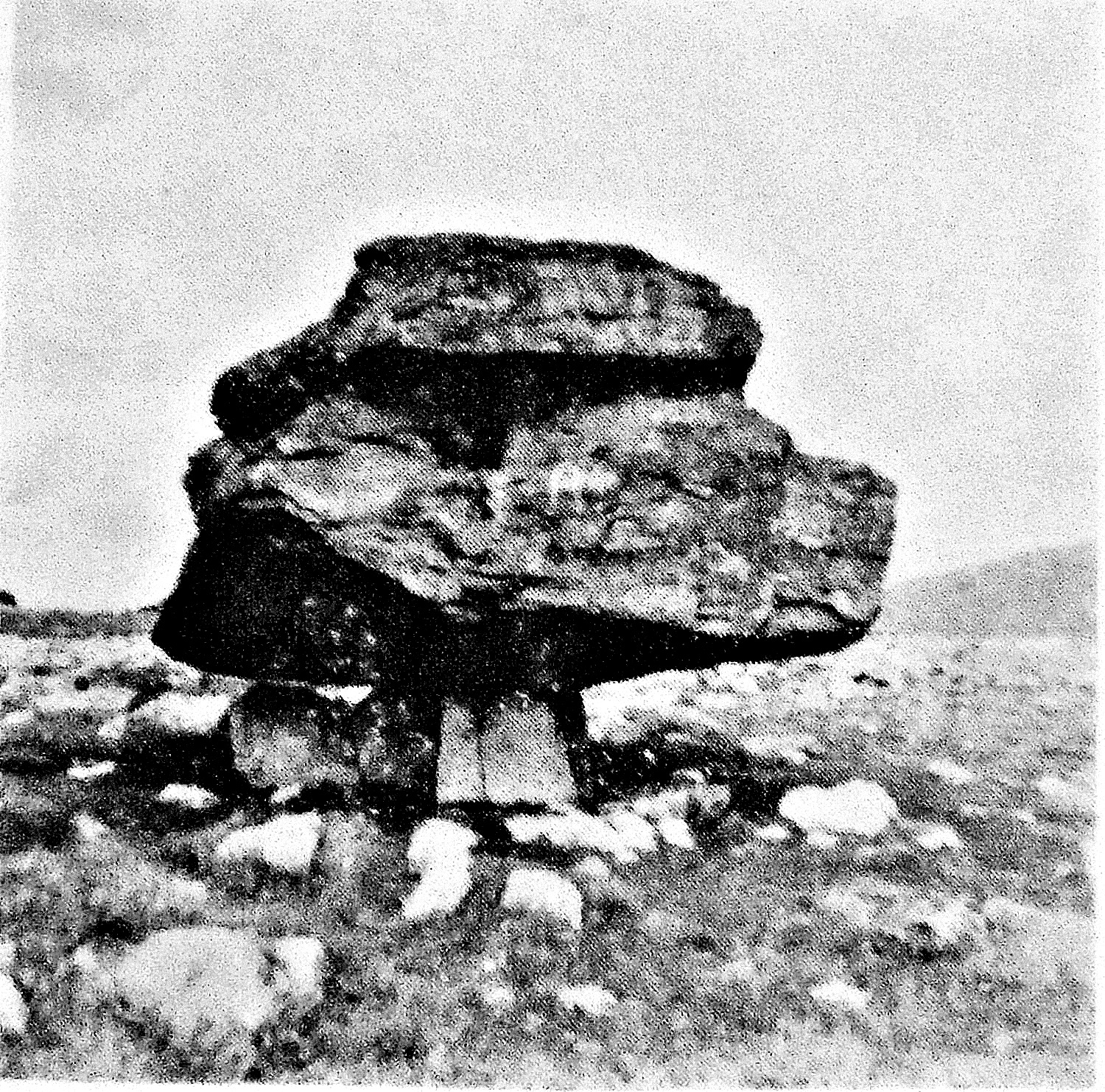
Arthur’s Stone in Herefordshire.

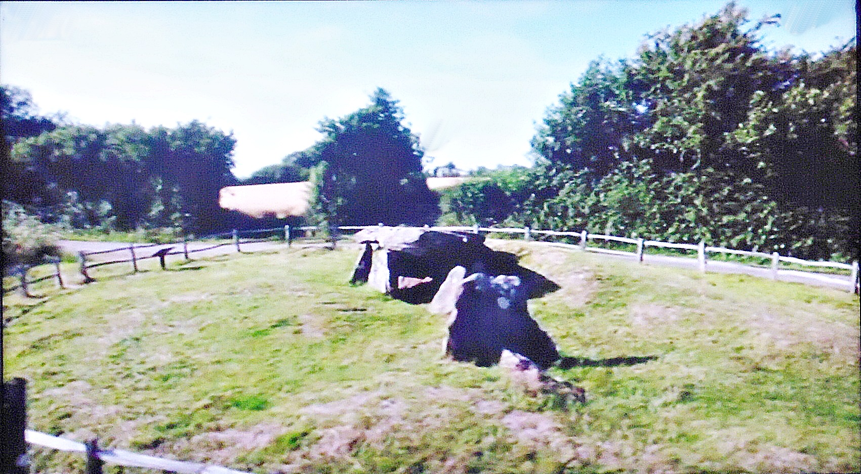
NGR: SO 3188 4313. On Arthur’s Stone Lane, near the B4348 road and about 1 mile north of Dorstone, overlooking the Golden Valley, Herefordshire, stands the prehistoric monument known as Arthur’s Stone, a multi-chambered Neolithic burial tomb dating from 3,700-2,700 BC. The chamber stands upon a nearly circular low mound or bank 26 metres long orientated north to south, that is cut off by the country lane at the eastern side. The large capstone, now broken in two, is supported by nine upright stones or orthostats; the capstone itself is thought to weigh 25 tonnes.

The entrance passageway at the north-west side is 4.6 metres long and inside there is the usual forecourt which consists of a series of stone slabs at intervals and an ante-chamber. There is a false entrance stone at the front side nearest the lane. Originally a mound of earth 3 metres high would have covered the whole chamber but this has eroded away over time.

Arthur's Stone, Herefordshire

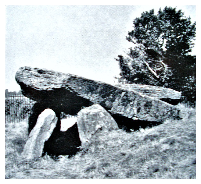
Arthur’s Stone, Herefordshire

To the south of the chamber there is the Quoit Stone, complete with cup marks and another stone, perhaps a peristalith – the cup marks on the quoit stone were made, according to local legend, by King Arthur’s elbows. Other legends tell of Arthur killing a giant here or the famous king himself being buried in the chamber, and even Arthur fighting in a battle close by. Otherwise, King Arthur has no real associations with the monument because it pre-dates him by many thousands of years. But almost certainly Arthur, if he did exist, would have seen the burial chamber and recognised its purpose – a burial tomb that was built for a person of greatness and reverence in more ancient times.

Copyright © Ray Spencer, The Journal of Antiquities, 2012.


St Trinian’s Chapel, Marown, Isle of Man

NGR: SC 3177 8023. The roofless medieval chapel of St Trinian stands in a field at the foot of Greeba Hill, just to the north of the A1 Douglas to Peel road, about three-quarters of a mile west of Crosby in the parish of Marown. Originally dedicated to the 4th century Scottish saint, Ninian, but later the name changed to Trinian. The 14th century chapel stands on the site of a Keeill – an ancient Manx name for chapel – indeed, the site is also called Keeill Brisht – meaning “broken church”.

It seems that an ancient burial ground and a chapel stood here from the 6th-10th century, but then sometime between 1200-1230 a medieval chapel was established on the raised circular site as a dependancy of the priory of St Ninian at Wigtown, Galloway, Scotland, but that building fell down so another chapel had to be constructed. However, according to local legend, a buggane (evil giant or goblin of Manx folklore) kept blowing the roof off, and so eventually the chapel was left alone without any roof, just as it is today.

The roofless chapel measures 73 feet by 19 feet with the gable (bell tower) some 21 feet in height; the walls are 2-3 feet thick. The nave and chancel survive as does the gable-ended bell tower and a rather broken altar. Some of the capitals show ugly carved human heads. Inside the ruin there are a number of incised stone slabs from the 10th-11th century. One has a thin cross within a circle, perhaps a grave-slab, another has a rather worn cross on it, while a third stone has what is probably a runic inscription on its face.

St Trinian’s or St Ninian’s Chapel, Isle of Man

Copyright © Ray Spencer, The Journal of Antiquities, 2012.


Mount Cross, Near Cornholme, West Yorkshire

Mount Cross, West Yorkshire

Mount Cross, West Yorkshire

NGR SD 9146 2782. Mount Cross, also known as ‘Idol Cross’ and ‘Stiperden Cross’, stands at the southern edge of Stansfield Moor, 2 miles north of Cornholme close to the Long Causeway, Todmorden. The ancient cross is located near Kebs Road to the east of Lower Mount Farm. It is a 5-foot-high free-standing cross although some stones are wedged in at the base to stop it from falling over – the wheel head measures 65cm by 38cm in diameter. Although the carvings on the cross are quite worn there are traces of roll-moulding, vine scrolls and also what may be an incised calvary cross.

The cross, now a registered ancient monument, is thought by some historians to date back to the 7th century AD when it was used as a preaching cross by St Paulinus; the general consensus is that it dates from the 10th or 11th century. It was discovered buried beneath The Great Bridestones to the south-east – a place that was associated with pre-Christian pagan practices; this is perhaps why Mount Cross has also been connected with the same sort of goings on and why it has often been called a “Rude Stone” although in Christian times a “Rood Cross”. The monument lies on an old causeway that links both Yorkshire and Lancashire, so it would have also made a good marker stone or guidepost for travellers crossing the moors. Mount Cross is said to be the oldest religious monument in the Todmorden area.

Copyright © Ray Spencer, The Journal of Antiquities, 2012 (updated 2024).


Norber Erratics, Austwick, North Yorkshire.

National Grid Reference: SD 7659 7003. High upon the moors a few miles to the north of Austwick and the A65 Ingleton road, North Yorkshire, are several large Silurian sandstone and slate boulders that were brought here at the last Ice Age between 12,000-15,000 years ago by glacial movement. These odd-shaped boulders (erratics) stand upon little limestone pedestals or stilts, some of which are up to 60 cm high.

Norber erratic boulder.

When the glaciers moved (retreated) south from the Lake District they picked up large stones and boulders on the floor of Crummackdale further to the north of Norber and, after the ice melted away these erratics were deposited or shifted upwards – usually up to the higher ground to the west of the Pennines. These large glacial boulders are said to be from the Ordovician geological period some 400 million years ago, while the white limestone beneath them is obviously much younger – only 100 million years ago. Over many thousands of years the boulders have protected the little pedestal formations beneath them from the weather, whereas the other surrounding limestone has been worn away, and that is why the boulders have been left looking like they are today – up in the air! The name erratic means “scattered about”.

Copyright © Ray Spencer, The Journal of Antiquities, 2012 (updated 2024).


St Andrew’s Church, Kildwick, West Yorkshire

Cross fragments in St Andrew's Church, Kildwick.

Cross fragments in St Andrew’s, Kildwick.

OS grid reference: SE 0109 4586. Inside the church of St Andrew on Skipton road at Kildwick (Childeuic), near Keighley, west Yorkshire, are several lumps of stone that have Anglian/Viking decoration. They are most probably cross-shaft fragments that date from the mid-10th century AD and are carved with scrollwork designs, interlacing and cable-moulding etc. One of the lumps of stone shows Christ holding an L-shaped object, perhaps representing the Resurrec-tion. Another shows a man with arm upheld, and a beast on each side, possibly representing Christ as the Good Shepherd. These pieces of cross-shaft may have once formed part of the Saxon churchyard cross that was erected in 950 AD when the first church was built.

Cross fragment with figure of Christ.

Cross fragment with figure of Christ.

    These fragments of ancient crosses are at the south side of the church near the Choir Vestry. They were discovered built into the interior wall above the chancel arches (south side) in 1901 – during restoration work, and had been used as masonry when the church was lengthened in the 15th century. Also found in 1901 were some pieces of a stone coffin lid that was covered with herring-bone patterns – again probably dating from the late Saxon period, while a stone in a recess near the top of the doorway has a Maltese cross and a St Andrew’s cross carved onto it. The Octagonal font is of the 15th century and has a shield on each side with monograms or emblems. Close by there is an oak chest with three locks. The lid has a slot for “Peter’s Pence” money given as contributions for the support of the Pope in the Middle Ages.

Sources and related websites:-

Wood, Alec, History and Description of the Parish Church of St Andrew Kildwick-in-Craven, 1996.

Copyright © Ray Spencer, The Journal of Antiquities, 2012 (updated 2023).


St Tecla’s Chapel, Beachley, Gloucestershire

OS Grid Reference: ST5484 9002. On a tiny island in the Severn estuary about half a mile south-west of Beachley, near the Severn bridge, stands an ancient ruined chapel that was originally dedicated to St Tecla (Treacla) and, later to St Triog, Rioc or Twrog. The island called Chapel Rock is frequently cut off by the dangerous tidal waters of the estuary and access can only be had when the tide has gone out. The ruined chapel, now only a few walls and an archway, dates from the 13th century, although there was an older chapel on this site back in the so-called ‘Dark Ages’. Inside the ruins there is a holy well that was once well-known for its healing properties. In the 1540s the chapel was abandoned and left to crumble away, the people were now fed up of having to wade across the estuary and sometimes even having to stay on the island for many hours when they were caught out by the fast, incoming tides.

St. Tecla’s Island in the Severn Estuary.

Little is known about St Tecla who was, according to legend, a 4th-5th century princess from Gwynedd, north Wales, and daughter of an unidentified Romano-British king or chieftain called Requli or Reguli. St Tecla became an anchoress on the island after abandoning her father’s court in order to seek a religious life, but she was later murdered in her cell by sea pirates. She is probably the same saint who has a couple of churches dedicated to her in mid and north Wales (Llandegley), but her name has often been confused with a 1st century female saint called Thecla, who was a follower of St Paul the Apostle. In the 6th-7th century her cell was used by another Welsh saint called Triog or Rioch, and it was he who kept a beacon burning on the island to warn sea vessels of the dangerous rocks (known locally as Chapel Rocks). Today a more modern solar-powered lighthouse stands on the island.

But, there was a 6th century St Tecla or Tecychius, who was a disciple of St Tatheus (Athan), according to author Bryan Walters, in his work ‘The Archaeology And History Of Ancient Dean And The Wye Valley’. So could the tiny island chapel and its holy well be dedicated to this saint?

Sources:

Barber, Chris., Mysterious Wales, Paladin, London, 1987.

Barber, Chris., More Mysterious Wales, Paladin, London, 1987.

Walters, Bryan., The Archaeology And History Of Ancient Dean And The Wye Valley, Thornhill Press, Cheltenham, Gloucestershire, 1992.

Copyright © Ray Spencer, The Journal of Antiquities, 2012 (updated 2022).


Bardsey Island, Gwynedd, North Wales

NGR: SH 1209 2236. Bardsey Island (Ynys Enlli) or ‘the island of the currants’ lies 2 miles off the southern tip of the Lleyn Peninsula across Bardsey Sound, locally called ‘The Race of Bardsey’. Since the early 6th century AD the island has been a “Cradle of Celtic Christianity”. It apparently takes its name from Bardda, a Welsh prince, but in 516 St Cadfan came here from Brittany at the invitation of Einion, King of Lleyn, to establish a Celtic (clas) monastic college. Since that time the place has been called the holy island of Bardsey and, when 20,000

Bardsey Island Taken from Braich y Pwll - at t...

Bardsey Island Taken from Braich y Pwll – at the end of the Lleyn Peninsula (Photo credit: Martin Connolly).

saints were “supposedly” buried there, its place on the list of holy, sacred sites had been sealed and the island became a place of pilgrimage. Since medieval times three pilgrimages to Bardsey Island were equal to one pilgrimage to Rome, and many still visit the holy island even today. St Cadfan died and was buried on the island in 540 AD as were St Cybi and St Dubricius. Legend says that Merlin the Magician lies sleeping in an unidentified cave on Bardsey Island.

Unfortunately, there is no trace of the Celtic monastery, the scant ruins there now are, in fact, those of the Augustinian abbey of St Mary that was founded in 1240 and, the main part of that still surviving is a ruined tower (abbots lodging) and some foundations of the abbey church. The abbey did not survive the dissolution of the monasteries in 1537. In the ancient cemetery there are two modern Celtic crosses; the taller cross stands in memory of the third Baron Newborough and the other for the 20,000 saints who lie in unmarked graves on the island – 900 of these were monks who fled from the monastery of Bangor-is-Coed near Wrexham when it was besieged and burnt to the ground by King Ethelfrid of Northumbria in 607 AD.

To the east of St Mary’s Abbey at Ty Capel is the holy well. This now supplies the island with its drinking water. Just east of Plas Bach is the hermit’s cave and near here stands the famous 1,000-year-old ‘Afal Enlli’ the Bardsey apple tree. At the northern side of the island at Penryn Gogar there are traces of round hut dwellings that belong to the Neolithic age some 5,000 years ago. At Ty Newydd farm some graves from the 10th-11th century were discovered during an archaeological excavation in 1995 along with some skeletons, one of which had a silver coin in its mouth.

Photo (above) is of Bardsey Island taken from Braich-y-Pwll – at the end of the Lleyn Peninsula, by Martin Connolly (Geograph/Creative Commons).

Copyright © Ray Spencer, The Journal of Antiquities, 2012 (updated 2023).


Walton Spire, Nelson, Lancashire

Walton Spire, Lancashire

Walton Spire, Lancashire

NGR: SD 8941 3732. Standing on a flat plateau of land overlooking the valley between Colne and Nelson where flows Pendle Water and the Calder, 2 miles north-east of Nelson, is the 27-foot-high monument called ‘Walton Spire’, also known as Walton’s Monument and The Nelson Cross. In 1830 an ornate stone spire with a four-armed cross that has inscriptions carved onto it was placed upon a ‘Dark Age’ stone menhir (marker stone) or pillar with a 7-foot circumference by Mr R.T.Wroe Walton of nearby Marsden Hall, Nelson, now called Marsden Park.

The inscription on the arms of the spire recalls: REG: CIRINDICA. AD 1835 STR: FEC: R.T. WROE WALTON HA COL AG: SHELL which may be translated as ‘ R.T. Wroe Walton had this monument made in the year of Our Lord 1835 and erected at Shelfield’.

According to legend, the ancient menhir was set up to commemorate the ‘battle of Brunanburh’ which was fought close by in 937 AD. The battle was between King Athelstan of England and a ragtag army of Northumbrians, Scots, Vikings and Welshmen led by Anlaf the chieftain, from the north-east. Sadly, Mr Wroe Walton damaged the menhir by having it carved flat with eight sides and then shaped so that his decorative spire would fit nicely on top of the ancient marker stone (this would not be allowed to happen today!).

The plateau where the spire stands is called Shelfield Hill and is thought by some historians to date back to prehistoric times, perhaps the Iron Age, but in the 10th century AD the site was chosen so that Saxon warriors could look down upon the valleys at either side and keep a watch for any would-be invaders approaching the area. 200 yards to the northwest stands a curious stone shaped like an anvil. Indeed the stone is locally called ‘The Anvil Stone’, Thor’s Stone or The Druids Altar. Walton Spire stands on an alignment with the Broadfield earthworks, the Anvil Stone and Castercliffe Iron-Age fort and other ancient sites in the Burnley area.

Copyright © Ray Spencer, The Journal of Antiquities, 2012 (updated 2024).